Gray skies, humidity return after Houston’s spectacular weekend

After a stunning weekend, Houston will see varied conditions as fronts move back and forth across the area this week. By and large, temperatures will be warmer than the last several days, but not overly so. We’ll also see a reasonable number of rain chances, although we’re not expecting anything at all threatening.

Monday

The story today will be winds starting to blow more forcefully from the south, with gusts up to 20 mph, and this onshore flow will yield more clouds and humidity. Highs will reach the mid-70s. Some very light, scattered rain showers will be possible later today and tonight in response to rising moisture levels. Monday night’s lows will only drop into the mid-60s.
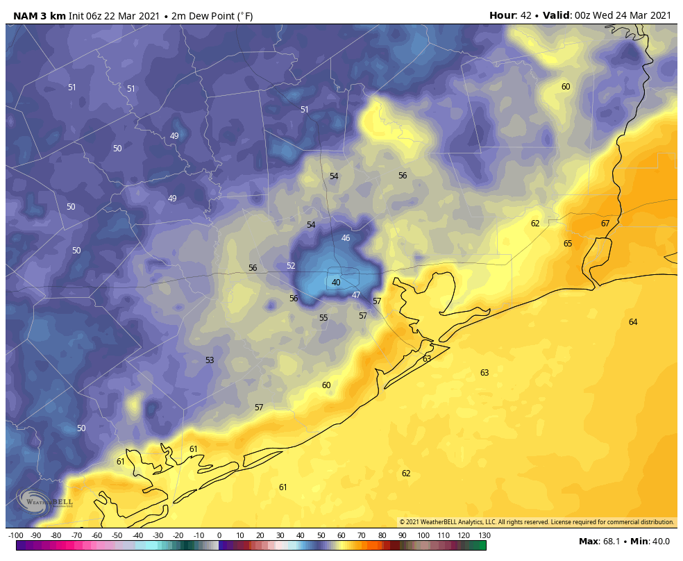
NAM model dewpoint forecast shows the extent of Tuesday’s front push into Houston. (Weather Bell)

Tuesday

This warmer weather will continue Tuesday as a weak front approaches the region. The front may spark a bit more organized showers, with some thunderstorms possible as the front nears Interstate 69, and as it moves toward the coast. Rain chances should end around noon, with sunny skies moving in behind. Highs will get into the upper 70s to 80 degrees. Right now it looks like the front will stall near the coast, with lows dropping to around 60 degrees on Tuesday night.

Wednesday and Thursday

These will be a pair of warm and humid days, with highs around 80 degrees. Skies will be mostly cloudy and each day will have at least a slight chance of scattered, light showers. At some point on Thursday—shortly after noon, during the evening hours?—a stronger cold front will push through Houston and move offshore. This, again, may generate some slightly more organized showers and thunderstorms, but skies should clear up in its wake with overnight lows dropping into the 50s.
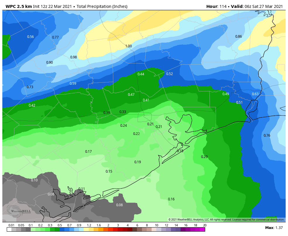
NOAA rain accumulation forecast for now through Friday. (Weather Bell)

Friday, Saturday, and Sunday

Friday and Saturday should be nice, springtime days, with highs of around 80 degrees, and lows around 60. Skies should be mostly sunny. We have more questions about Sunday, as another front is likely to move through Houston at that time and may produce some scattered showers. For now, however, I’d guess the front’s passage will be a dry one, but we’ll have to get back to you on that one.

We’ve had several questions about weather for Easter Sunday, and I’d love to be able to offer you some kind of helpful forecast. But for now it’s simply too early to say much of anything. The most likely forecast is highs in the 70s, but really it could be anything at this point.
Spring break week for many to close out with more nice weather

Good morning! We are in store for a delightful weekend of weather here in Houston, so I want to touch on a couple items before we get into the forecast details: Hurricane season & drought.

Changes coming to the 2021 hurricane season

The World Meteorological Organization (WMO) met this week, as they do each year to discuss hurricane names that should be retired, among other items. If you have not yet heard, some newsworthy items came out of that meeting.

First off, several storm names were retired. Since they didn’t meet due to the pandemic last year, both 2019 and 2020 were addressed this year. For 2019, the only retiree was Hurricane Dorian, which devastated the Bahamas in particular. Tropical Storm Imelda, which killed 6 and caused roughly $5 billion in damage as a storm many across Southeast Texas won’t soon forget was not retired. Imelda will appear again in 2025. For 2020, Hurricane Laura was retired. Hurricanes Eta and Iota, which both devastated Nicaragua were also retired. For those curious, Dexter will replace Dorian in 2025 and Leah will replace Laura in 2026.

In addition, the Greek alphabet was retired. No, really. The WMO agreed that if a season’s name list was exhausted, shifting to a list of Greek letters was too confusing. So they now have what amounts to an auxiliary list of storm names that will be utilized in the event we use all the names on the primary list for that season.

I believe that if one of those names is retired, it will just disappear and be replaced like any other season. Previously, they could not retire Greek letters.

Thoughts: Matt’s opinion here, but I’m not entirely surprised Imelda was not retired. That doesn’t necessarily make it right, as I feel Imelda coming sort of on the heels of Harvey makes it a special case for a highly populated, if small-ish area of impact. Claudette in 1979, which flooded Alvin terribly was never retired either. So there is certainly precedent, but again, if it were Matt’s decision, retiring Imelda would kind of be like having Harold Baines in the Baseball Hall of Fame. There’s a case one could make there, even if it is very, very borderline. As far as the Greek letters being canned? I like it a lot. I think this is absolutely the right decision, and it will create much less confusion and distraction, should we get there again.

Drought worsening

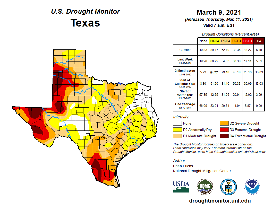
The Drought Monitor was updated yesterday, and although Wednesday’s rain is not included in this calculation, drought did worsen across both Texas as a whole and locally in the Houston area.

Move the slider left or right to see a comparison of Drought Monitor maps for Texas from last week and this week. Drought continues to encroach on the Houston area from all sides. (US Drought Monitor)

The only part of Texas not really seeing drought get worse is the El Paso area and far west, as drought is already pretty bad there. The Greater Houston area went from about 35 percent of the region in drought last week to almost 60 percent this week. NOAA’s outlook for the next few months suggests drought will maintain or worsen across Texas.

As we’ve noted, this is a story we will continue to follow.

Today & weekend

We will close out the week on a cool but sunny note. There are some high clouds that could drop in from the north today, but short of that, expect sunshine and 60s this afternoon with a bit less wind than yesterday. Saturday should be similar with mainly sunshine but at least some chance of high clouds at times. We’ll start in the 40s in most places tomorrow, warming into the 60s, with areas south and west of Houston pushing back near 70 degrees.

Our winds will shift onshore on Sunday, with warmer, more humid air beginning to gradually filter in off the Gulf. Look for morning lows in the 40s and low-50s and highs in the upper-60s to low-70s and a good bit of sunshine once again.

Next week

A pair of upper level systems will move into the region, with the first arriving later Monday and Tuesday and another later in the week. These will each help drive a cold front into the Houston area, along with a chance of showers and storms. As is often the case this time of year, there are questions as to how far offshore the fronts will get or if they (particularly the first one) will fall apart over us. Either way, look for a somewhat unsettled week next week with a couple days of rain chances and generally warm temperatures. We should see a final front push well off to our east and somewhat cooler weather arrive by later in the week or next weekend. We will have finer details for you on Monday.

Houston to enjoy another absolutely splendid spring weekend

Temperatures this morning, dropping below 50 degrees for many inland areas, are the coldest they’ve been in 10 days after much drier and cooler air blew in over night. The region will now see four or five days of splendid spring-like weather before rain chances begin to creep up next Monday or Tuesday.

Thursday

After northerly winds near the coast gusted up to about 40 mph on Thursday night, they’ve died down a bit this morning. However we’ll have to wait until this afternoon or even the evening to see gusts drop below 20 mph. Conditions otherwise will be sunny today, with highs in the upper 60s. Overnight lows will drop into the upper 40s for everywhere but coastal areas. This should be the coldest night of the week.

Low temperature forecast for Friday morning. (Weather Bell)

Friday

Conditions may remain a bit breezy on Friday, as our northerly flow continues. Temperatures will be about the same as Thursday, with highs in the upper 60s under sunny skies. Overnight lows will probably be a degree or two warmer than Thursday night for most locations.

Saturday

This is about as nice a day as you could draw up for March in Houston. We’ll again see sunny skies, and highs should reach about 70 degrees with ample dry air. Winds will be very light, if not calm. Make your outdoor plans now!

Sunday

We may start to see a touch of humidity by Sunday, but conditions should still be very pleasant, with highs in the low 70s, and partly to mostly sunny skies. Overnight temperatures will be warmer, with some areas possibly not falling below 60 degrees on Monday morning.

Houston will see solid sunshine until Sunday, at least. (Weather Bell)

Next week

Clouds will increase by Monday, and rain chances will likely be on the way up by Tuesday as the atmosphere becomes a little bit more perturbed. Thus we may see highs around 80 degrees and decent storm chances from Tuesday through about Thursday, after which time the next front may push into Houston. The details of all this remain hazy, however.

Storms possible today as a front moves into Houston, with much more severe weather well to our east

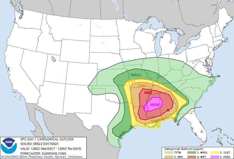
Good morning. Today will see a line of thunderstorms move through the Houston area between 7 am and Noon, to be followed by an influx of drier air across the region. This storm system will find more favorable conditions east of Houston, and there is a large area of the southern United States where severe storms—including tornadoes and hail—could form later today. NOAA hasn’t issued a “high” risk warning for severe storms, which is the magenta-colored area centered over Mississippi in the map below, since 2019. This is a serious situation, and any travel east of the greater Houston area today should be carefully considered.

NOAA severe weather outlook for Wednesday and Wednesday night.

Wednesday

As of around sunrise, a fairly organized line of storms is moving through the College Station area, and this will continue to advance toward Houston this morning. However, due to a capping inversion, we expect the intensity of these storms to weaken as they move into the city. They should exit to the east by around Noon or 1pm. Rainfall accumulation for most will be around 0.25 inch, which is unfortunate because many areas could use a little more than this. We cannot rule out an isolated strong thunderstorm, so take care when out and about this morning in Houston.

Glorious spring time weather eventually awaits us behind the front, and we should see clearing skies this afternoon as drier air moves into the area. Lows tonight will drop down to around 50 degrees, and winds may gust as high as 30mph out of the north.

Higher resolution view of NOAA storm outlook for Wednesday and Wednesday night. (NOAA)

Thursday and Friday

Thursday will start out gusty as well, but winds should die down some during the afternoon and evening hours. We’ll see sunny skies throughout the end of the work week, with highs in the upper 60s to 70 degrees, and lows in the upper 40s for the most part. It looks like Friday night will be the coldest night of the week.

Saturday and Sunday

Saturday will see full sunshine and highs of around 70 degrees, but as winds take on a more southerly flavor we may see a few clouds start to pop up by Sunday, when highs may climb into the low- to mid-70s. Rain chances remain near zero throughout the weekend.

Forecast low temperature for Friday morning. (Weather Bell)

Next week

We’ll see a continued warming trend into the early part of next week, as highs get into the upper 70s perhaps, with slightly better rain chances and more clouds. It looks like some kind of front will work its way through on Tuesday or Wednesday, but I don’t have any confidence in the details.

So for now, enjoy our amazing spring-like weather in the days ahead, and check on friends and family members in the southeast after the storms there later today and tonight.