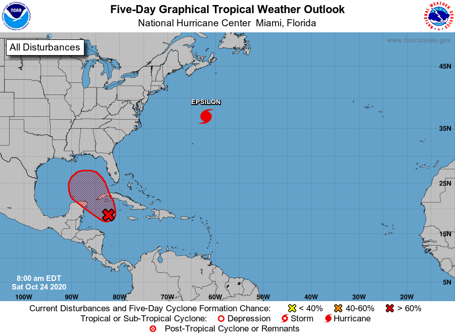
Good morning. We are interrupting what is going to be a gorgeous Saturday in Houston with a brief tropical update due to popular demand. Several of you—dozens, even—have written to ask about the low pressure system expected to enter the Gulf of Mexico over the next couple of days. The National Hurricane Center gives this system a 90 percent chance of becoming a tropical depression or storm, so we’re probably looking at Tropical Storm Zeta within a day or two.
Five-day tropical outlook from the National Hurricane Center.
This system, dubbed Invest 95L for now, is likely to meander around the northwestern Caribbean Sea for a day or two before moving west-northwest into the Gulf of Mexico. By early next week the system is going to be moving almost directly toward Texas, which may seem fairly ominous.
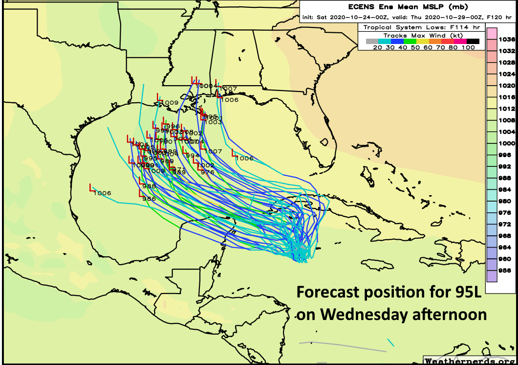
Forecast position, per European model ensemble, for Invest 95L next Wednesday. (Weathernerds.org)
However, after this time a couple of things are expected to happen. One, a cold front is going to be moving down across Texas, and this stronger push should reach the Upper Texas coast by around late Wednesday or early Thursday. This will ultimately steer the storm north, and then northeast. Additionally, wind shear is forecast to increase over the northern Gulf of Mexico next week, which should weaken whatever develops.
In any case, it seems possible that a tropical storm could come ashore along the central or southeastern Louisiana coast, or further east, sometime next Wednesday or Thursday. It’s difficult to say too much more, too precisely, given that 95L remains fairly broad in appearance and lacks a distinct center. However, we can be confident this is not something Texas should lose much sleep over.
Over the next week or so, southeast Texas is going to be visited or perhaps taunted by several cold fronts. We still have questions regarding the exact timing of most of them, but we can continue to point to some windows of when they’re most likely. Our first one arrives later today. Let’s break it down.
Today
Our first cold front is still off to the north, steadily heading this way. That won’t arrive until later, and ahead of it, look for a few showers or perhaps a thunderstorm through the day. Many places will probably stay dry, but in general, the odds of storms may increase a bit late this afternoon. More of the same temperature-wise, with 80s and fairly uncomfortable humidity.
The front should arrive in the northwest suburbs late this afternoon and in the immediate Houston area after 4-5 PM or so. Behind the front we’ll see temperatures drop off 5 or 10 degrees, and you’ll notice a fairly brisk breeze out of the north.
Weekend
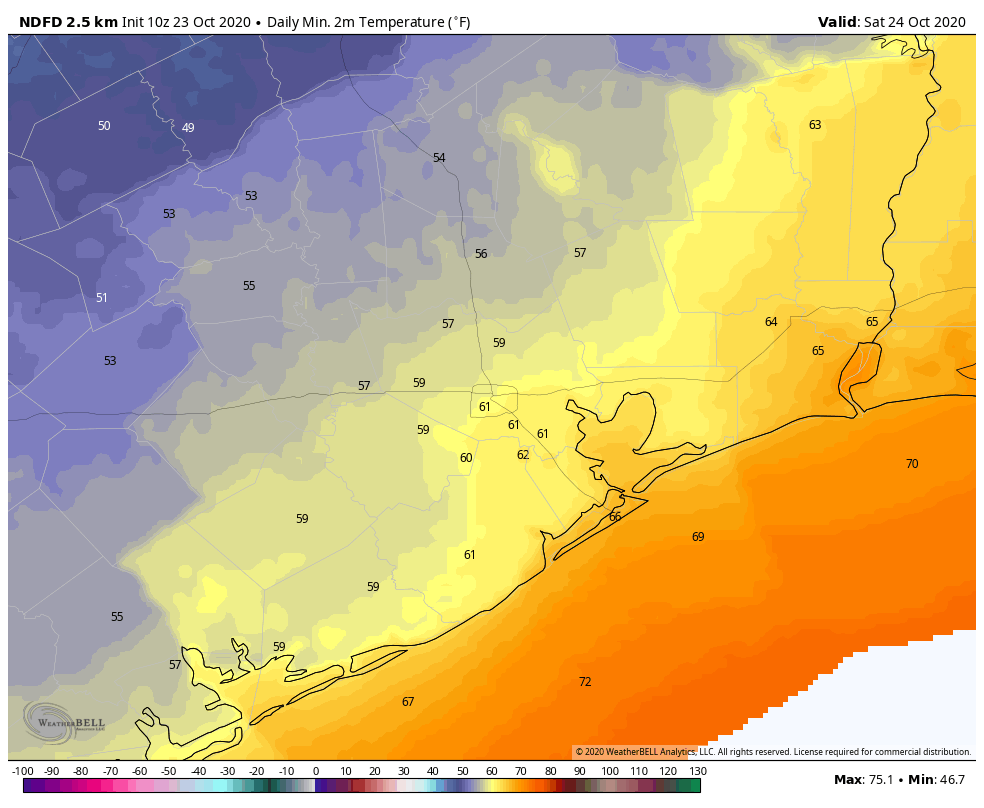
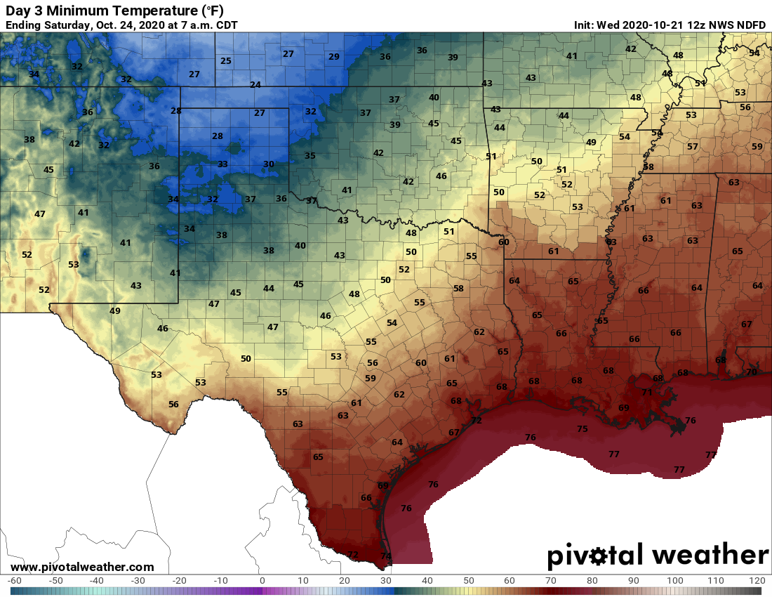
Saturday morning will start off much cooler than we’ve had in recent days. Many places will start in the 50s, with 60s south and east of Houston.
For those looking for a more autumn feel, Saturday morning will provide low temperatures that fit the script a bit better. (NOAA forecast via Weather Bell)
Expect a good deal of cloud cover tomorrow morning. We should see increasing sunshine in the afternoon. High temperatures will top off in the mid-70s in most places. If clouds are a bit more stubborn, we may not get out of the upper-60s, however.
Onshore flow resumes later Saturday, and the humidity will slowly inch back up into Sunday. Morning lows on Sunday will be in the 60s in most places. With a mix of clouds and sun, we’ll probably make it to 80 degrees or a couple degrees warmer on Sunday afternoon. We’ll mention that a passing shower cannot be entirely ruled out Sunday, though it’s likely to be dry in most places.
Next week
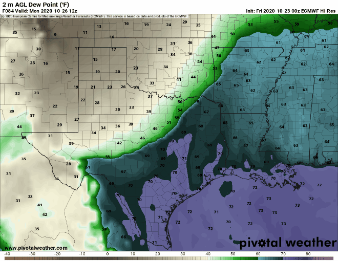
Things turn very, very messy from a confidence in details perspective on Monday and Tuesday. Another cold front pushes into the Houston area, but it appears that this one is going to stall out right over the city, almost perfectly over US-59/I-69. This means clouds, perhaps some sun, and at least a chance of showers and storms. Temperatures later Monday and Tuesday may be rather variable across the area with the east side perhaps 10 to 15 degrees warmer than the west side of the region with high humidity south and east and lower humidity north and west. This can be seen when you look at forecast dewpoints from the European model.
Forecast dewpoints from the European model show the front, the boundary between more humid and less humid air straddling the Houston area from late Monday into early Wednesday. (Pivotal Weather)
Notice how the boundary between the more humid air (in purple and dark turquoise) and less humid air (in green) basically straddles Houston for most of Tuesday before shifting back west (meaning everyone warms up a bit) on Wednesday. Basically, this is a front that taunts us mostly.
After it pushes back west on Wednesday, look for a warm day. The front should finally get a shove through the entire area by Thursday or Friday. I don’t want to commit to a day just yet because modeling has handled fronts in the days 5 to 8 range quite poorly this autumn. But we still believe we’ll get a clean cold front passage late next week, hopefully setting up a nice daylight saving time weekend. More on that Monday!
In case you missed it, today is our fifth anniversary at Space City Weather! It’s a privilege to be part of this, and thanks to Eric for keeping me around these last five years. We have some fun things planned down the line, and as always we’ll be here when you need us.
It is difficult for me to believe, but Space City Weather turns five years old tomorrow. (Here’s our first post). I remember it well. I left the Houston Chronicle’s downtown office that afternoon, a Friday, after a nice send-off from my colleagues following 17 wonderful years at the newspaper. I had intended to at least take the weekend off before starting a weather website, as a hobby. But with impending storms and heavy rain that weekend, my wife and I put off a celebratory dinner on Friday night while I created Space City Weather and dove headlong into the effort. Matt joined from the outset and Reliant soon came on as a sponsor. Then, Hurricane Harvey hit two years later, and the rest is history.
Looking ahead, we’re going to continue to make site improvements. Most notably, many readers have asked for an app. Frankly, making a free, quality app is a really big ask for such a small site like ours, but we are planning to make this happen in the coming months, and will have more to say soon. We also are planning other small improvements, but the site is going to remain true to the core mission that I outlined in that first post five years ago—”informative, hype-free forecasting.” Thank you to everyone who was there at the beginning, or found us along the way.
Thursday
Temperatures are generally in the low 70s across the Houston area this morning, with dewpoints to match, making for fairly humid conditions. This has also led to some fog in the area that has reduced visibility. After the fog dissipates we can expect a partly sunny day, with highs in the mid 80s, along with light southeast winds. We can’t rule out a few isolated showers, but they should be fleeting. Lows tonight will be similarly warm.
Friday
This day will start out a lot like Thursday, but will change as a front pushes into the area. The front should arrive in northwest areas, such as Brenham, around sunset, push through the city during the evening or overnight hours, and reach the coast around midnight or a few hours later. Some models are now suggesting the front may have a little more oomph than we first anticipated, allowing for low temperatures to possibly drop into the 50s on Saturday morning. Emphasis on possibly.
Saturday
In the wake of this front, conditions will be pretty nice on Saturday, with partly to mostly sunny skies and highs likely only reaching the upper 70s. However, the front is going to wash out pretty quickly, so with onshore winds returning we can expect a warmer night, likely in the upper 60s for most.
Temperatures in Houston should be 10 to 15 degrees cooler on Saturday morning than Friday morning. (Weather Bell)
Sunday and Monday
We should be back to fairly humid, warm weather on Sunday and Monday, with highs somewhere in the 80s and plenty of sunshine.
Next week
When it comes to next week’s forecast we’re still in something a of a throwing darts at a dart board mode. Some models want to bring a strong front into Houston late on Monday or Tuesday, with a reinforcing front later in the week, making for much cooler fall weather all week. Others bring a front close to Houston on Tuesday, before it stalls, and awaiting a reinforcing front later in the week to push all the way off the coast. So while we’re pretty confident significantly cooler weather is on the way, I’m not sure whether that happens on Tuesday or Thursday. The good news is that whenever a front does push all the way through, it should also bring some rain with it. Again, details on how much, etc., remain very much up in the air. Literally!
Good morning. If you’re out and about near Galveston Bay this morning, please take a few extra minutes due to fog. Skies will clear out later this morning with mostly clear conditions, and we expect sunny weather through the weekend.
Wednesday
Houston remains caught between high pressure over the eastern United States, and low pressure to our southwest. This creates a fairly stagnant pattern, with our surface conditions dictated by an onshore flow. As a result, high temperatures today will again push up into the mid- to upper-80s. Winds will be light, out of the east and southeast. And low temperatures again tonight will only drop into the low 70s for most of the area. Rain chances are about 10 percent, or less.
The current pattern favors easterly and southeasterly winds for the upper Texas coast. (Weather Bell)
Thursday and Friday
More of the same, to be honest, until Friday night. A front will approach the region on Friday afternoon or evening, and it should reach the I-69 corridor by around midnight, and the coast by or before sunrise on Saturday morning. This is a weak front, so don’t expect fireworks. I expect its passage will be dry in terms of rainfall, and should only moderate dewpoints and temperatures a few degrees—it’s impact will be more significantly felt well inland, in places such as College Station.
Saturday and Sunday
Highs on Saturday may dip into the low- to mid-80s due to the front, but should rebound back into the upper-80s on Sunday.
This should be about the extent of the cool front’s cooling on Saturday morning. (Pivotal Weather)
Next week
So what’s the progress on a stronger front early next week? We’re still in what I’d call watch-and-see mode, but I’m penciling in its passage for some time on Tuesday. This has the potential to be a pretty strong front, but there’s still a lot of fuzz in the models and the signal is not overwhelming. I think that when the front finally makes it we will see a pretty decent shot of rainfall, and since the region has been rather dry we’ll take what we can get. Hopefully we can have this part of the forecast nailed down better by tomorrow morning.