We’re excited to announce the second winner of a complete AC system from Reliant! As you may recall, for the second year in a row, our sponsor has given away two AC systems to Houston area residents to help them beat the heat—and there has been plenty of heat to beat this year.
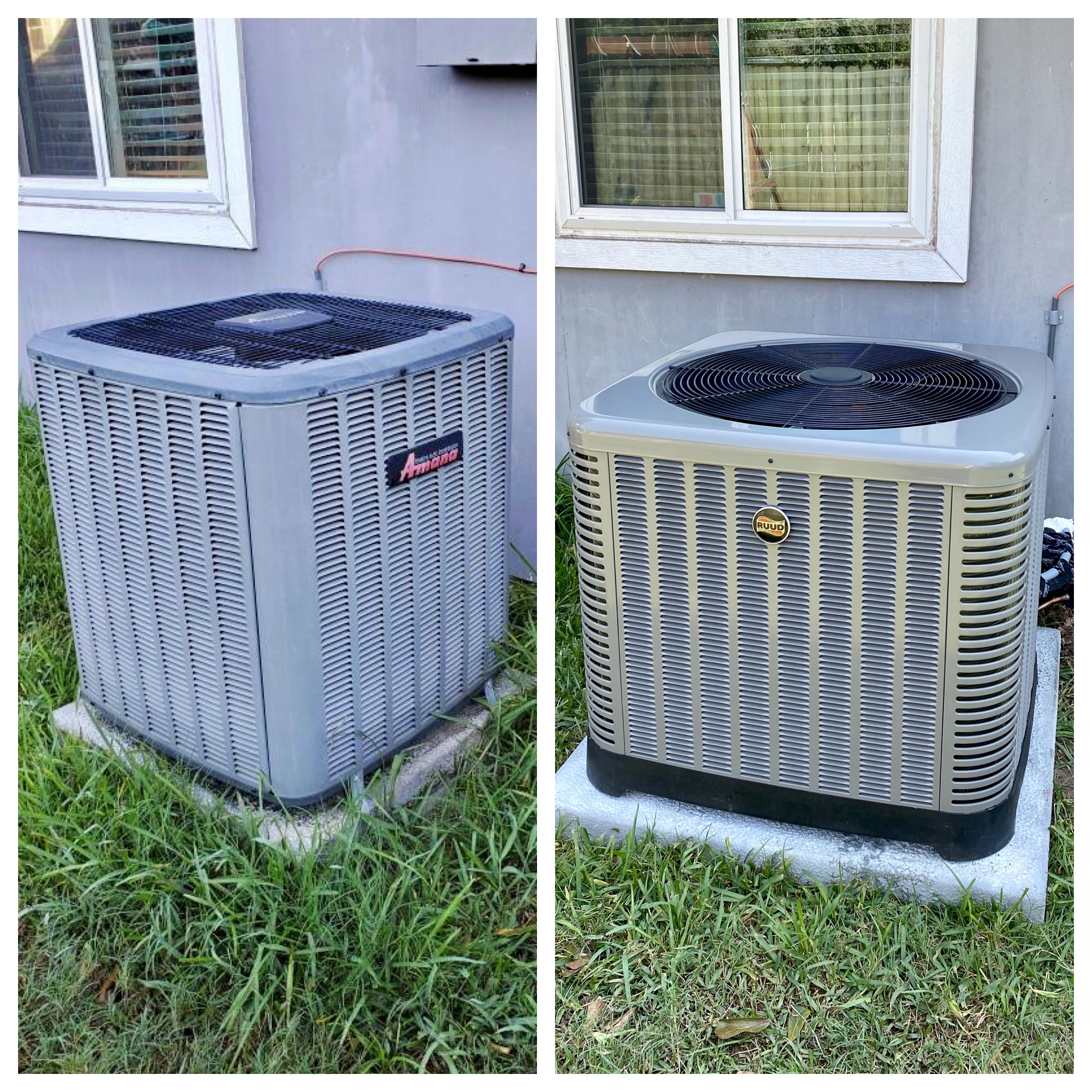
The winner of Phase II of Reliant’s AC Giveaway, Cassie and her family. (Photo courtesy of Reliant)
The winner of this year’s second AC System is Cassie, who lives in Friendswood. She has four children, some of whom are participating in virtual learning this fall due to COVID-19. She found out about the contest through our site’s Facebook page and decided to enter to keep her family comfortable while working and schooling from home safely. The family’s previous AC unit was in decent condition, but leaked water, wasn’t placed to code, and didn’t cool the house efficiently. So the installation of the new unit will make a world of difference for Cassie and her family. After learning that she had won the contest, here’s what Cassie had to say:
We are so grateful for Eric Berger and his weather team. They are our number one source of information! Winning this sweepstakes is such a bright spot after a truly very difficult summer. Thank you, thank you to Space City Weather and Reliant!
Likewise, we are thankful for our readers, as well as Reliant, who has been a great, long-time sponsor of our site. They keep the lights on for us, figuratively and literally.
In addition to providing electricity, Reliant alos offers AC and heating services, generators, indoor air quality checks, and thermostats through their home services division, plus special offers for Reliant customers. Check out this link for more information.
Before, and after. (Reliant)
This will wrap up the AC giveaways for 2020, but we’ve got some big things planned for Space City Weather and Reliant in the coming year, so be on the lookout for announcements soon. Thanks to everyone who participated!
Given the weather events of the last couple of days—a hurricane making landfall in Louisiana, high temperatures in the low- to mid-90s across Houston—you’d be forgiven if you thought the calendar read mid-August, rather than mid-October. However a pair of fronts this week will remind us that we’re heading deeper into fall.
Monday
It is rather warm and muggy this morning, with lows only on the mid-70s across the region, and sweaty dewpoints to match. With the exception of areas far to our northwest, such as College Station, a cold front will not arrive in time to modify our high temperatures today, which should reach around 90 degrees.
However, the arrival of this weak front later today in Houston should bring drier air into the region overnight, allowing for lows to generally drop into the upper 60s. There will be a slight chance of rain showers with the frontal passage later this afternoon or evening along the coast. Although the front will be most noticeable west of Interstate 45, it is now expected to make it all the way off the coast.
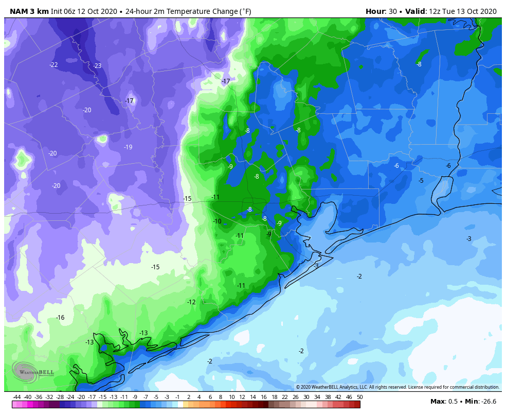
Change in temperatures for Tuesday morning, compared to Monday morning. (Weather Bell)
Tuesday
This should be a pleasant day, with dry air, highs in the mid-80s. Winds will be light, out of the north or northeast. Lows Tuesday night should drop into the low- to mid-60s. Skies will be clear.
Wednesday and Thursday
These will be a pair of slightly warmer, and more humid days while we await this week’s second front—due to arrive later on Thursday. Highs likely will be in the mid- to upper-80s, and there’s perhaps a 30 percent chance of rain on Thursday afternoon or evening as the front blows through. This will be a stronger front that will bring noticeably cooler weather for the weekend.
Friday
We expect to see mostly sunny skies, with highs perhaps only in the low 70s. Lows Friday night should be the coolest of the week, with temperatures possibly dropping into the 40s for areas well inland, and the 50s for most of Houston.
An early look at Saturday morning’s low temperatures. (Pivotal Weather)
Saturday and Sunday
We’re expecting a sunny weekend, with highs in the mid-70s to 80 degrees. The onshore flow may return by Sunday, or we may get yet another front—as of yet there is not great agreement on that in the global models.
2 pm CT Friday Update: Hurricane Delta is now moving north-northeast toward Louisiana, and will make landfall later this afternoon or early evening, likely around sunset. Delta has weakened slightly, to 110 mph, but because it has grown into a large storm it will push a powerful storm surge into Vermillion Bay and nearby areas. Its winds will batter areas already devastated by Hurricane Laura just six weeks ago.
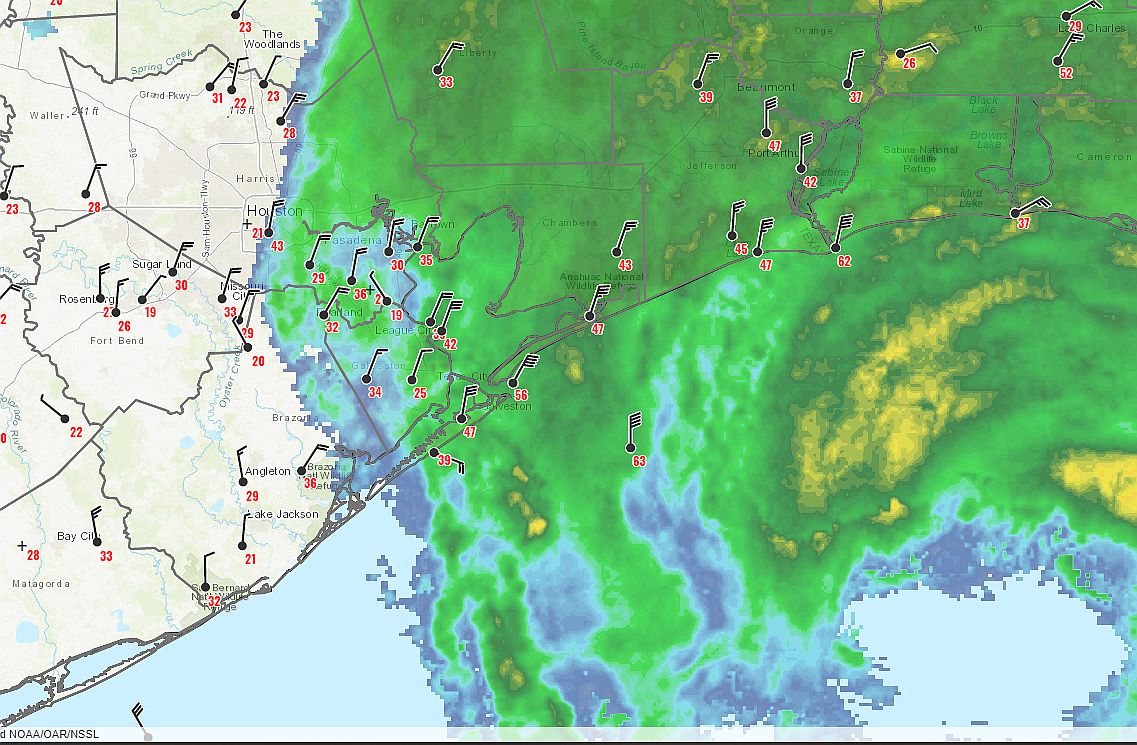
The winds we’re feeling in Houston today are due to that expanding wind field. Galveston Island recently recorded a gust of 58 mph, to go along with sustained winds of 45 mph—above Tropical Storm levels. Further inland, many locations in Houston have recorded gusts of 30 mph or above today. These winds are probably about at their maximum levels, and will begin to wind down later this afternoon or early evening as Delta moves further to the northeast.
Map of wind gusts and radar at 1:30 pm CT Friday. (National Weather Service)
As expected, rains have been falling primarily over the eastern half of the metro area, with as much as 1 inch near Galveston Bay, while no rain has come down over West Houston. Expect rain chances to ebb later this afternoon and evening as well.
It’s a similar story with tides and waves along the coast, but the storm’s approach at low tide (this afternoon) is helping to mitigate some of the surge we’re seeing along the upper Texas coast. We still expect to see a fair amount of beach erosion.
Delta will move quickly away tonight. The bottom line is that beginning tomorrow, summer returns to Houston, with sunny skies and, by Sunday, highs in the 90s. With fair weather over head, we should probably be thinking about what we can do to help our hard-hit neighbors to the east in Louisiana. They have endured a terrible one-two punch from the tropics this year.
6:20 am CT Friday: Hurricane Delta has completed its north turn and is now steaming toward the Louisiana coast. Delta is a large storm in size, and as a result, we are seeing some rain here in the Houston area, especially on the east side. But Delta will exit quickly tonight, setting the stage for a sunny weekend but also the return of heat.
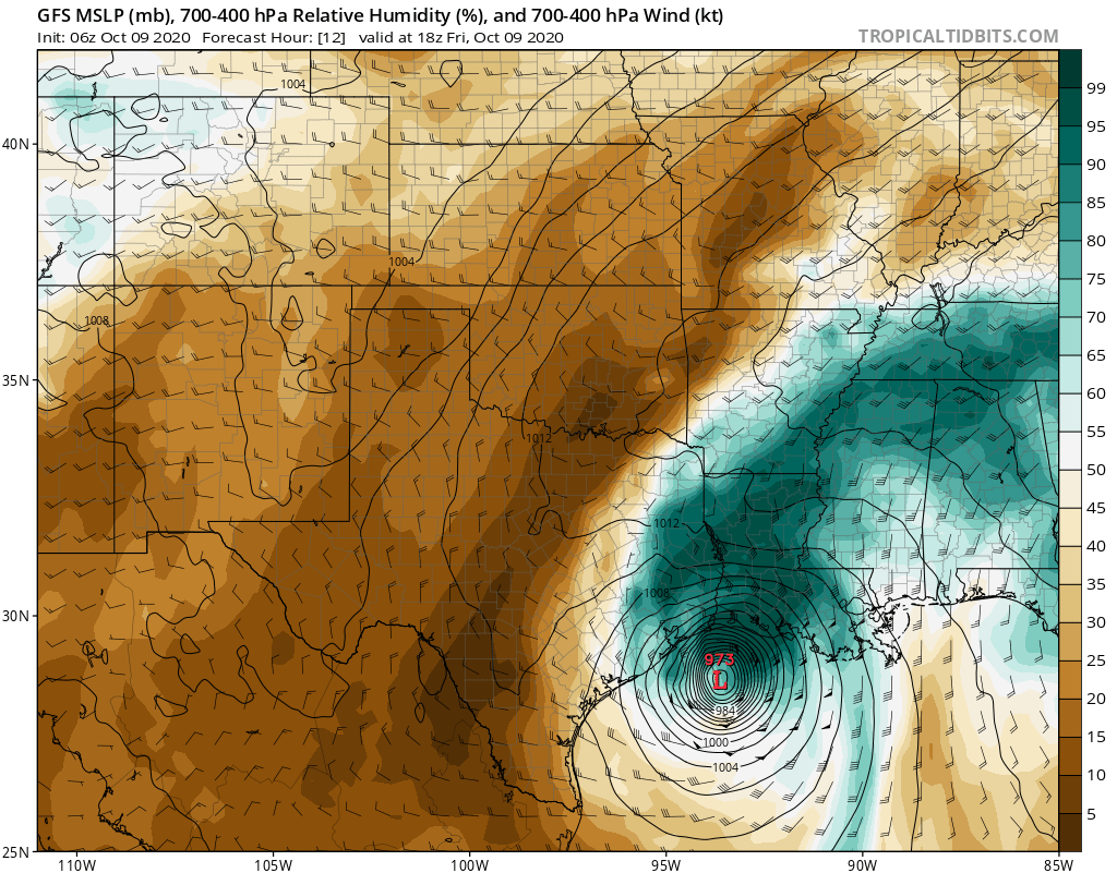
Hurricane Delta Update
As of the 4 am CT advisory, Hurricane Delta still had 120 mph maximum sustained winds, supported by observations from aircraft investigating the storm. Since that advisory, little has changed for the most part, but Delta is now moving into an area of high shear and cooler water temperatures.
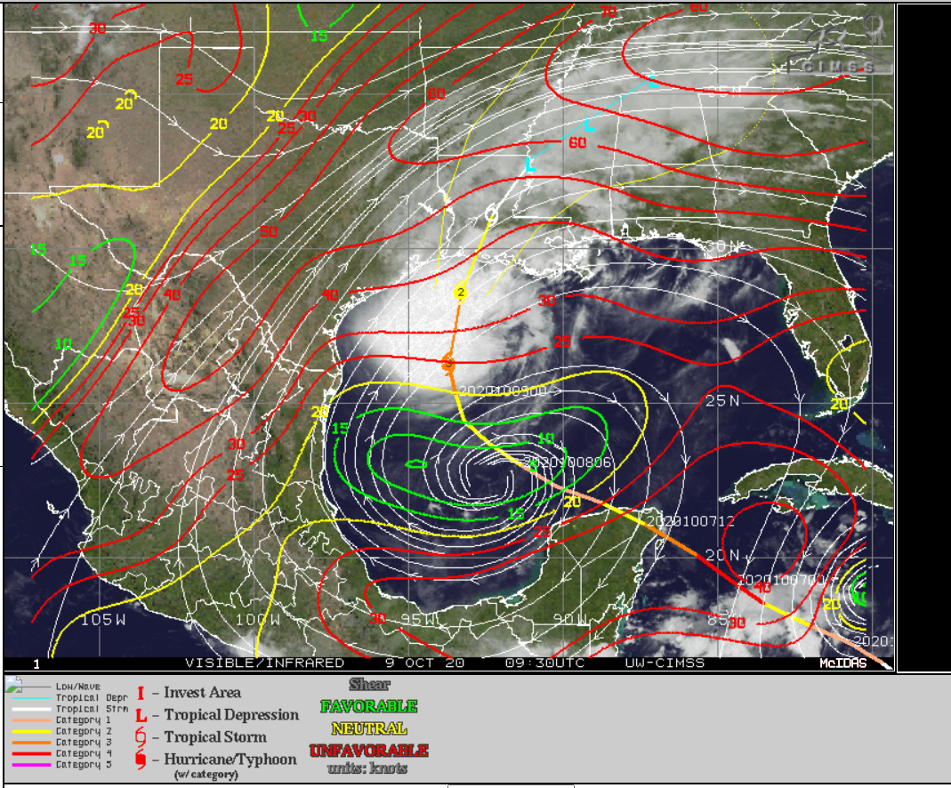
Hurricane Delta is moving into a much more hostile environment for a hurricane, with substantial wind shear (indicated by the red contours on this map), cooler water temperatures, and likely some dry air as well. (University of Wisconsin CIMSS/SSEC)
In addition, the southern side of the storm is beginning to feel the effects of drier air being swept off Texas and Mexico in the wake of its passage. The GFS model image below is valid for Noon today and shows drier air (brown) getting dragged into the southern half of the storm. Delta is likely to come ashore fairly lopsided, with a potent northern half and a much more frazzled and weaker southern half.
Dry air will also help to begin to weaken Delta as it wraps into the southern half of the storm through the day today. (Tropical Tidbits)
So this storm has likely peaked in intensity over the Gulf and will slowly weaken up to landfall. That said, it remains a dangerous storm, as the large size of it will allow for a storm surge in Louisiana that is more significant than the storm’s landfall intensity will probably suggest. In addition, the expansive tropical storm force wind field (which now has a radius of 160 miles north and east of the center) will allow for damaging winds in weakened, vulnerable parts of Louisiana. So for southwest Louisiana, this remains a serious storm.
Local impacts from Delta
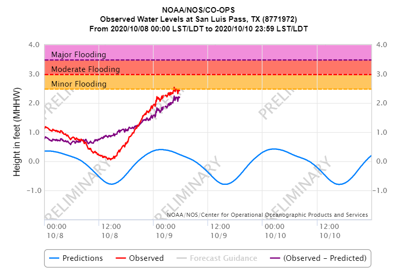
We have already begun to see tides increase on the Upper Texas coast. San Luis Pass is just on the cusp of minor flooding this morning.
San Luis Pass is just on the edge of minor flooding as of this morning’s high tide. (NOAA)
We are now past high tide, so this will likely level off now or perhaps rise just a little more. A similar story is playing out in Galveston. Tidal levels on our slice of the Texas coast will probably be similar to what we saw with Hanna and Laura and lower than what was experienced with Beta. Watch for the risk of some minor flooding from the Galveston Bay side in Bolivar and Galveston itself later today with winds shifting behind Delta.
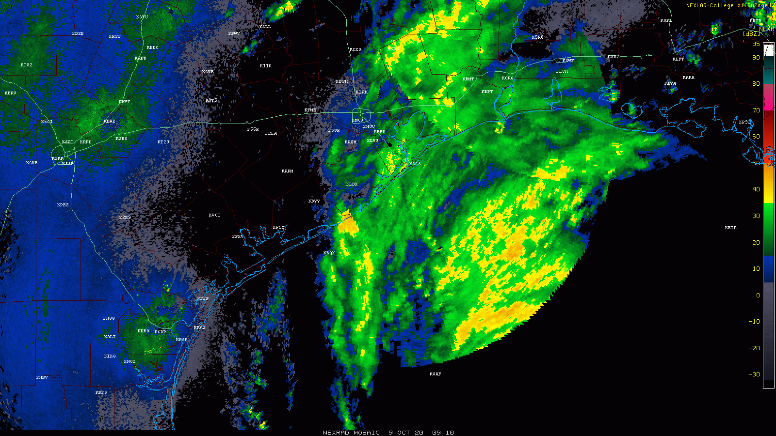
Rain continues to circulate in from the east, and most of the eastern half of the Houston metro has seen about a quarter-inch so far.
Rain will continue to pivot through the area during the course of the day. No flooding is expected in the Houston area. (College of DuPage)
Total rainfall in the Houston area should be under an inch for most folks, and no flooding is expected in our area. Look for upwards of 2 to 4 inches in the Golden Triangle, with minimal flooding issues expected and 6 to 8 inches in Lake Charles, where street flooding could be a bit more serious of a problem.
Winds at Galveston are gusting just a bit under tropical storm force this morning (35 mph as of 6 AM). We could see sustained winds or gusts to tropical storm force (45 mph or so) along the immediate Gulf coast. In Houston, wind gusts will be unlikely to get much past 25 or 30 mph, and no serious issues are expected due to wind for the vast majority of the region. Winds in the Beaumont area could gust to 40 to 50 mph, with slightly higher winds closer to the coast. In Lake Charles, winds could gust as high as 50 to 70 mph for a time later today, with hurricane conditions on the immediate coast of southwest Louisiana, in addition to a significant storm surge on the immediate Gulf coast there.
Eric and I continue to send our thoughts and best wishes to our neighbors in the east. Even a best case scenario outcome with Delta is still a pretty bad day for southwest Louisiana, and they will continue to need our help in recovery.
After Delta: Weekend
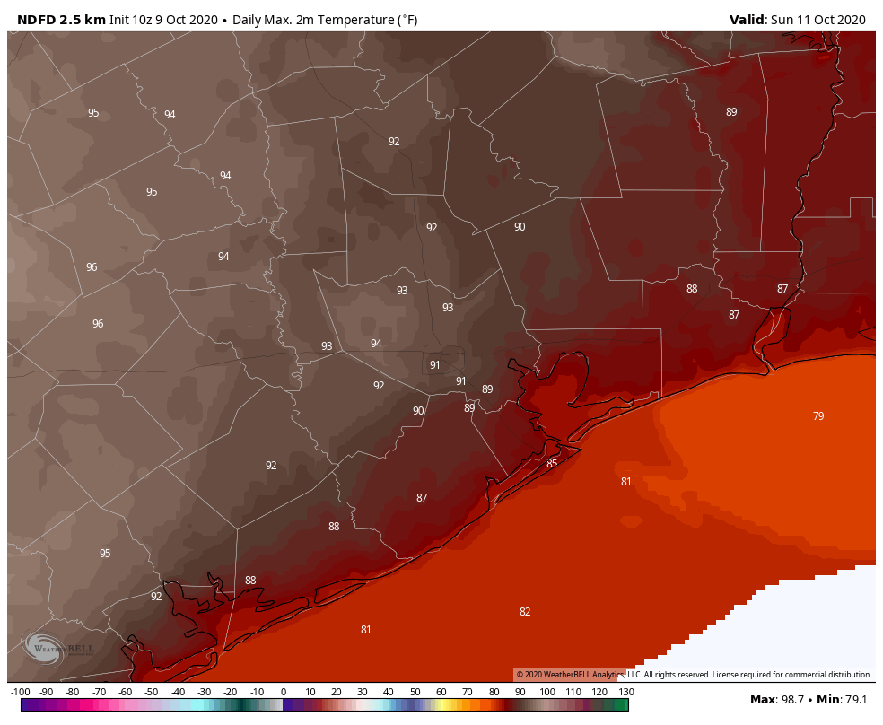
With Delta moving off to the north tonight and tomorrow, the Houston area is going to clear out quickly in its wake. Saturday should be a lovely day, albeit a bit warm. Expect sunshine with highs in the upper-80s. Humidity should be tolerable. More sunshine will follow Sunday, but temperatures are going to crank up and so will the humidity. Sunday is going to feel like a summer day, with highs in the low to mid-90s.
Sunday will feel like early September, with highs in the low to mid-90s and fairly uncomfortable humidity. (NWS forecast via Weather Bell)
For the holiday on Monday, expect more of the same, with at least low-90s and sunshine.
Tuesday & beyond
A cold front is likely to press into the area later on Monday, but how far south it gets is an open question. While a few showers will be possible, we expect this wash out over us, which should lead to a slight cooldown in temperatures and slightly lower humidity. By the end of the week, we may see a more robust cold front enter the picture, driving in more pleasant weather for next weekend, but even that is not a guarantee at this point. More on this for you on Monday.
Our next update on Delta will be posted by 2:30 pm CT today.