Good morning. The ongoing weather forecast remains more or less the same, with hot, but not too hot weather, and the potential for isolated to scattered rain showers most days. This is basically what August is like when there is no dominant ridge of high pressure overhead, or a low pressure system moving in from the Gulf of Mexico.
Thursday
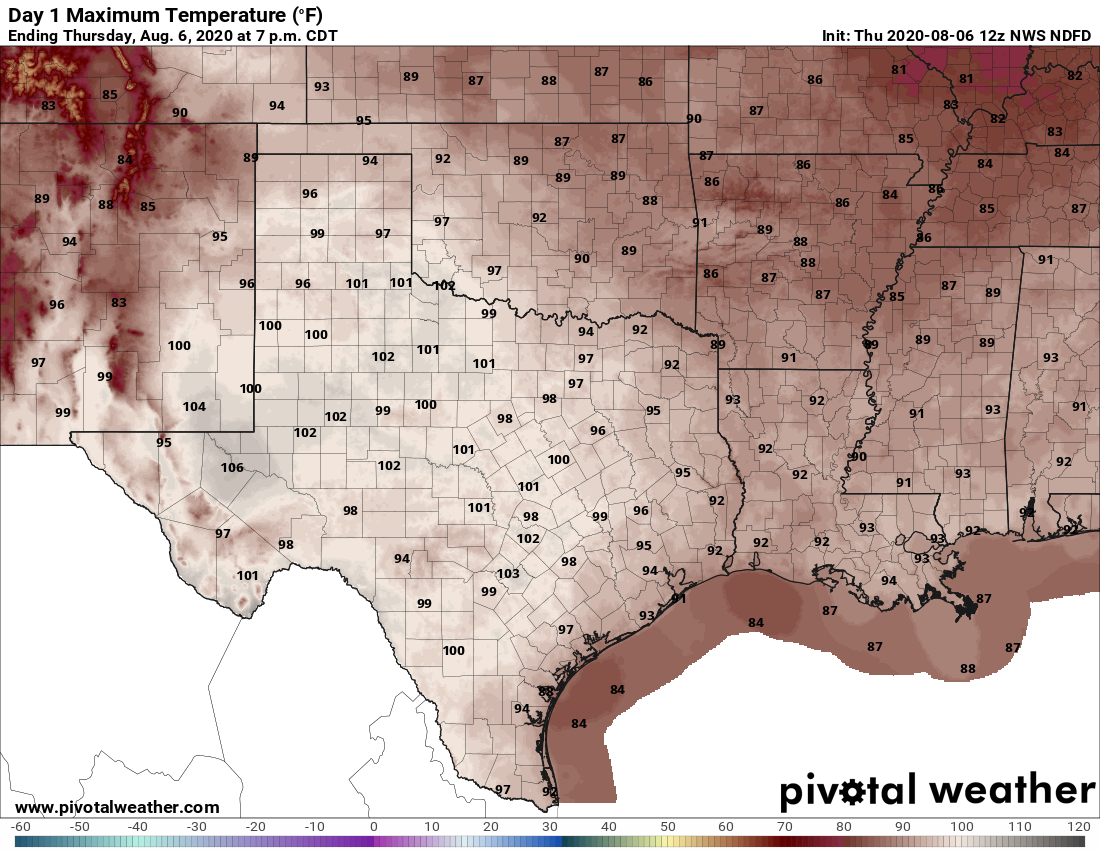
Skies today will be mostly sunny, allowing highs to rise into the mid-90s. As high pressure strengthens in the region we don’t anticipate much in the way of rainfall, although it is possible a few stray showers may develop east of the city. Winds will be light, out of the southeast at 5 or 10 mph later today. Low temperatures will fall into the mid-70s for inland areas tonight, while remaining near 80 degrees along the coast.
It will be August-hot for most of Texas on Thursday. (Pivotal Weather)
Friday
With the ridge firmly in control, we anticipate this being a hot and sunny day with highs in the mid-90s and almost no chance of rain.
Saturday and Sunday
The forecast for the weekend again calls for partly to mostly sunny skies, with highs in the mid-90s. However, slightly better rain chances enter the forecast due to a slight atmospheric disturbance that may push across the region. For most this probably won’t have too much effect, but it will nudge rain chances each day up to about 30 percent. They are most likely to develop during the afternoon hours.
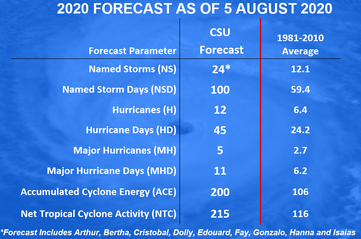
On Wednesday, the longest-running seasonal forecast program, based at Colorado State University, issued an updated outlook for the remainder of the 2020 Atlantic hurricane season. In a word, it’s going to be active. The forecasters are predicting a remarkable 15 more named storms this year, along with 10 additional hurricanes. This is very busy.
The Atlantic hurricane season officially runs through November 30, but for Texas’ purposes the chances of a hurricane strike fall dramatically after September. So realistically, we’ve got about eight weeks in front of us that we’re really going to have to stay on top of the tropics in the greater Houston area.
Updated forecast from the Colorado State University for 2020 Atlantic season.
One of the biggest issues complicating this year’s hurricane season is that, in addition to the overall tropical activity, it will occur against the backdrop of the COVID-19 pandemic. The virus remains quite active in the greater Houston area, as well as statewide. So with this post Matt and I wanted to provide some basic information about preparing for hurricanes in such an environment. We reached out to both city and county officials for up-to-date information.
Probably the most important thing about preparing for this season is taking the time now to think about how the pandemic will change your plans with regard to your family, any pets, any loved ones in harms way, and more. With hurricanes we sometimes have days and days of warnings, and sometimes we have 48 hours or less with a late-developing storm, or one making a quick turn. Preparing a disaster kit (see checklist), having a plan to protect key records, knowing your home’s vulnerability to storm surge flooding (see map), and under what circumstances you should evacuate are all things that can be done well in advance of a storm.
“It’s vital that everyone in our community take time and effort to prepare, regardless of the circumstances of the time or what the predictions are,” Harris County Judge Lina Hidalgo told Space City Weather. “As we’re all seeing, hurricane season doesn’t give us the courtesy of taking a year off just because we’re coping with a pandemic. Now, more than ever, we implore everyone to develop a plan, to put together an emergency kit, and to build a kit. As you prepare for this hurricane season, take some time to look over your family’s emergency plan and see how COVID-19 may affect it.”
Preparing to evacuate
In recognition of this hurricane season as an abnormal one during a pandemic, the U.S. Centers for Disease Control and Prevention has published a guide on COVID-19 and hurricanes. Here are some of the highlights from this information:
If you may need to evacuate, prepare a “go kit” with personal items you cannot do without during an emergency. Include items that can help protect you and others from COVID-19, such as hand sanitizer with at least 60% alcohol, bar or liquid soap, disinfectant wipes (if available) and two masks for each person.
Determine now where you will evacuate to. How will you get there? This detailed map of evacuation routes (it’s a big file) will help you plan now.
If you are staying with friends and family, talk now about how you would best protect yourselves from COVID-19. If you plan on staying in a hotel, check now to see if they’re open, and can accommodate your needs.
Pay attention to local guidance about updated plans for evacuations and shelters, including shelters for your pets.
Houston will see fairly typical August weather for the next week, which is not entirely bad news. This is the time of year when temperatures can soar into the triple digits—but the absence of a strong high pressure system will keep our highs a little bit more moderate. We also, at least at this time, see no evidence of really heavy, organized rainfall. In short, we’ll take it.
Wednesday
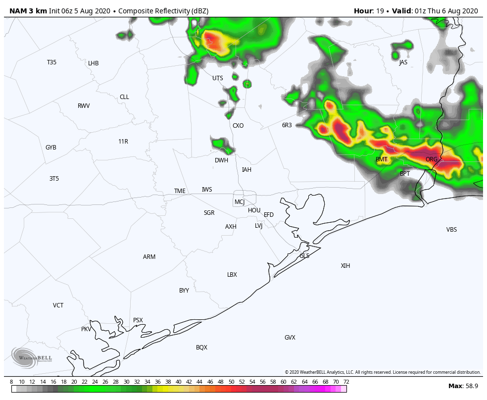
Of the remaining days in this work week, Wednesday may be the most active due to the passing of a disturbance in the upper atmosphere. Skies should be mostly sunny today, with highs rising into the upper 90s and calm winds. But by this afternoon daytime heating will combine with the disturbance to at least produce some scattered showers and thunderstorms. Most of the modeling shows this development to the east of Interstate 45, and some have the activity closer to Beaumont than Houston. Regardless, know it’s possible for thunderstorms to spin up this afternoon and evening before dying down with the loss of daytime heating.
NAM model forecast for radar reflectivity at 8pm CT Wednesday. (Weather Bell)
Thursday and Friday
As high pressure builds over Houston we can probably expect a pair of mostly sunny days, with highs in the mid-90s. Rain chances should be quite low, probably 10 percent or less.
Saturday and Sunday
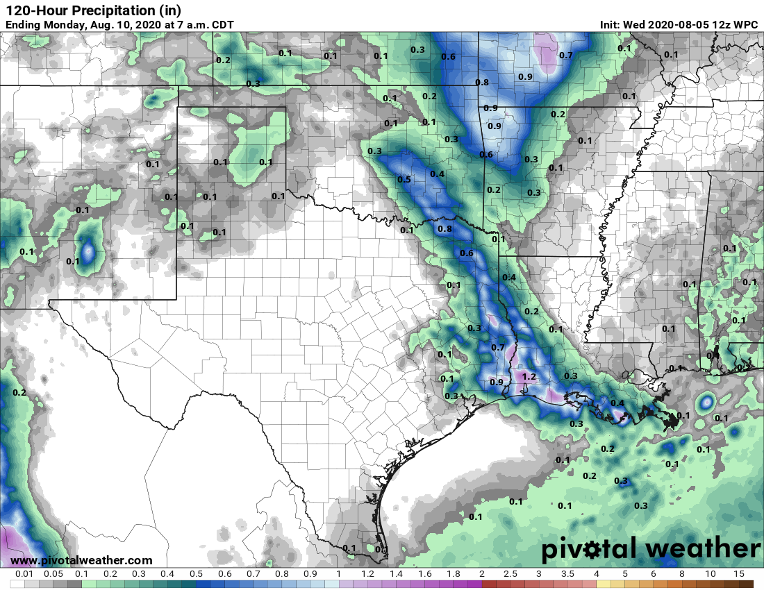
The high’s influence should diminish over the weekend, returning Houston to a pattern of partly to mostly sunny days, with highs in the low- to mid-90s. We’ll again see the possibility of afternoon showers and thunderstorms, but most likely they’ll be scattered.
NOAA rain accumulation forecast for now through Sunday. (Pivotal Weather)
Next week
Honestly, there’s not much to say about the extended pattern. We expect similar conditions to more or less prevail for awhile—not too hot, not too wet. As we’ve said, this is probably about as good as we can expect for August.
Tropical Storm Isaias is bearing down on the Mid-Atlantic and Northeast today, and as that storm exits, we actually look to settle down into a period of calm for a bit in the tropics. All good things must come to an end however, and as we go into the back half of August, we will begin to refocus our attention on the entirety of the Atlantic basin. For now, let’s enjoy the respite.
Tropical outlook in a sentence
No meaningful tropical activity is expected over the next week, although conditions will likely begin to get more active by August 15th or so.
Isaias
Isaias experienced a bit of a renaissance last night, ramping up to a moderately strong category 1 hurricane as it made landfall near Ocean Isle Beach, NC.
Since last evening, Isaias has raced northward and been downgraded to a tropical storm. The center is over the Mid-Atlantic this morning, heading toward Upstate New York or western New England by evening. Along its path will be flooding rains, strong winds, and some tornadoes still to come for places including Philadelphia and New York City.
Behind Isaias
In the Atlantic, we actually have no real disturbances of note behind Isaias. Yes, there is the disturbance dubbed Invest 94L, which is a few hundred miles southwest of Bermuda this morning. That one is unlikely to do much and is certainly not a threat to the U.S. There may be a tropical wave that emerges in the Bay of Campeche this weekend, but that is not expected to develop at this time as it likely moves into Mexico.
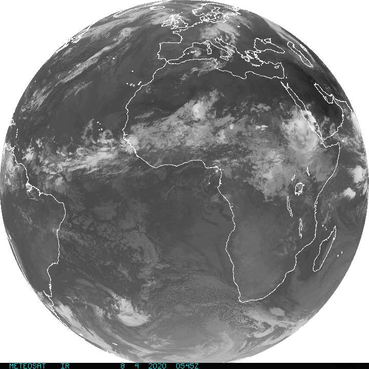
Meanwhile, off Africa, we are seeing some waves push across the continent and off the coast that look pretty robust.
The wave train will continue to send waves east to west across Africa and into the Atlantic over the next week or so, though none is considered especially likely to develop. (NOAA)
None of these are expected to develop, but it’s not entirely out of the question that something could develop. Either way, anything emerging off Africa today would be at least 10 to 14 days away from us here, so we couldn’t tell you anything with any specificity anyway. That said, at least for the next week or so, none of these waves appears to be a serious candidate for any kind of meaningful development.