Good morning. After several wetter days for the region, rain chances will slacken some to end the work week before returning again Friday night. As we head into August this weekend, high temperatures will likely remain mostly in the low 90s, which is fairly “pleasant” for what is typically the hottest time of the year in Houston.
Thursday
Some drier air is mixing into the atmosphere this morning, and this should help to limit shower and thunderstorm activity later today across the region. Rain chances are likely around 20 percent for most locations. Skies should become partly to mostly sunny this afternoon, and this will allow highs to warm into the low or mid-90s for the region. Winds, generally, will be light, coming from the south. Skies should turn partly to mostly cloudy tonight, leading to warm and humid conditions, with lows struggling to fall below 80 degrees for much of the region.
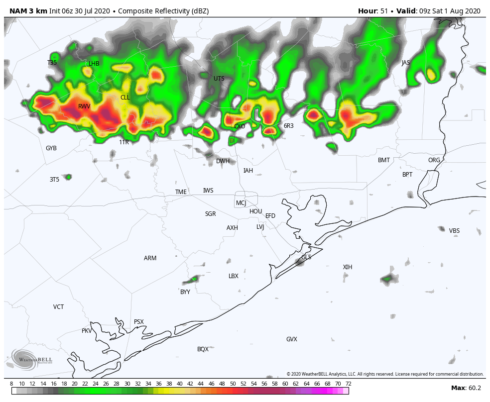
NAM model forecast shows potential of storms developing early Saturday morning. (Weather Bell)
Friday
Conditions will be similar on Friday, with partly to mostly sunny skies leading to another warm day with highs in the low- to mid-90s. Later in the day a dying cool front will approach the region from the northwest. This may ultimately bring some drier air into the northern half of the metro area, but initially it may lead to some storms over areas north of Interstate 10—particularly Austin, Waller, Washington, Grimes, and Montgomery counties. Some models indicate a line of storms moving into these areas between midnight Friday and Saturday morning. We’ll continue to track this to see if it’s likely to come to fruition.
Although they were somewhat scattered, storms that developed Tuesday across the metro area were briefly quite intense. Cells over areas such as the Energy Corridor west of Houston, Clear Lake, and near Sienna Plantation briefly recorded rainfall rates of 4 inches per hour, quickly backing up streets. We should see a similar pattern today, with the potential for some scattered, strong storms before a few drier days.
Wednesday
Although they should number fewer than on Tuesday, showers and thunderstorms will likely develop near the coast this morning and then gradually spread inland. Probably about 30 or 40 percent of the area will see anything between a few sprinkles and briefly heavy rainfall. Between any showers, skies will be partly sunny, and this should help high temperatures warm into the low- or possibly even mid-90s for areas that see mostly sunshine. Winds will be out of the south at 5 to 10 mph. Rain chances will (mostly) die back during the evening and overnight hours.
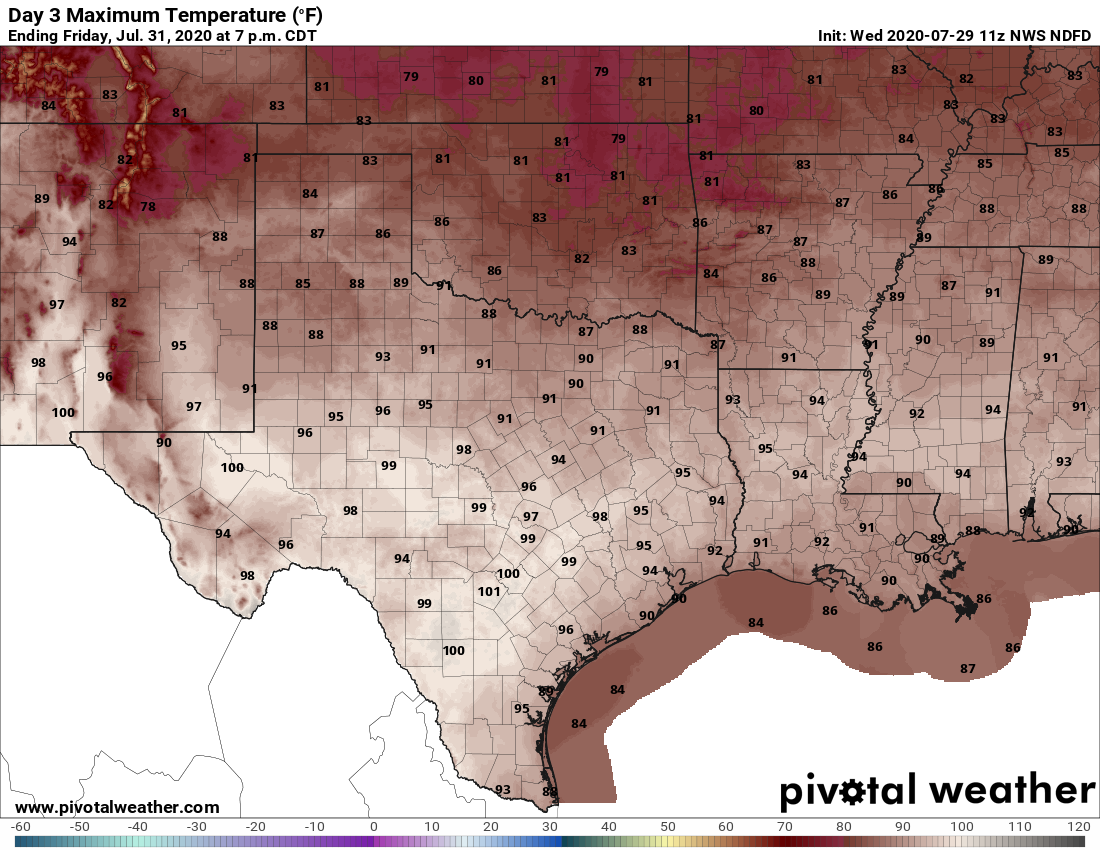
High temperatures by Friday will rise into the mid-90s for most. (Pivotal Weather)
Thursday and Friday
Houston will lie on the periphery of high pressure and this will help to bring rain chances down to the 10 to 20 percent chance level. As a result this should be a pair of mostly sunny, hot days with highs likely reaching into the mid-90s, and possibly upper-90s for inland areas. Winds will be light, out of the south or southwest, so don’t expect too much relief from these typical days for the end of July.
With Hurricane Hanna behind us, the obvious question is, “What’s next?” We have one system at present to watch, and then the situation gets a little trickier to figure out.
Tropical outlook in a sentence
The disturbance just dubbed “Potential Tropical Cyclone 9” by the National Hurricane Center is the one we are watching for development this week. Although we do not expect an especially strong system, it is still far too early in the game to dismiss any scenario or track.
PTC #9
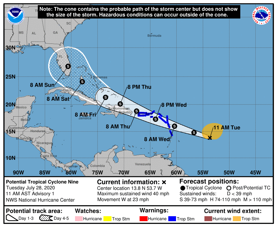
The road forward on where Potential Tropical Cyclone 9 goes and what it does is a long one, and we are still at the beginning. Possibilities range from no impact at all on the United States to an impact on the Gulf, US East Coast, or something in between. Basically, everything. That’s a less than helpful forecast, but it’s the only realistic one that can be offered right now. The National Hurricane Center’s designation of this disturbance as a “potential tropical cyclone” means it has confidence a depression or storm will develop and impact land soon. They will initiate advisories on this system this morning, which will allow for watches and warnings to be issued for Caribbean islands. Their first forecast is below.
The National Hurricane Center’s opening forecast for Potential Tropical Cyclone 9. There is *very* high uncertainty on details later in the forecast. (NOAA)
From their technical discussion, it’s worth noting that there is a very high degree of uncertainty. As they note:
It cannot be stressed enough that since the system is still in the formative stage, greater than average uncertainty exists regarding both the short-term and longer-term track and intensity forecasts.
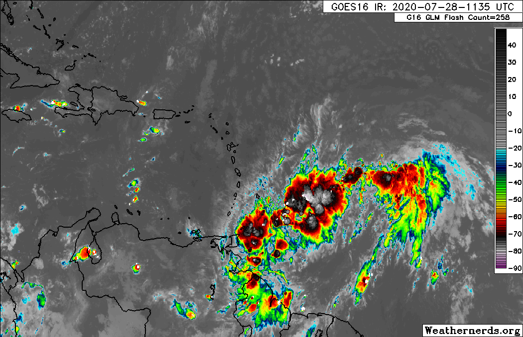
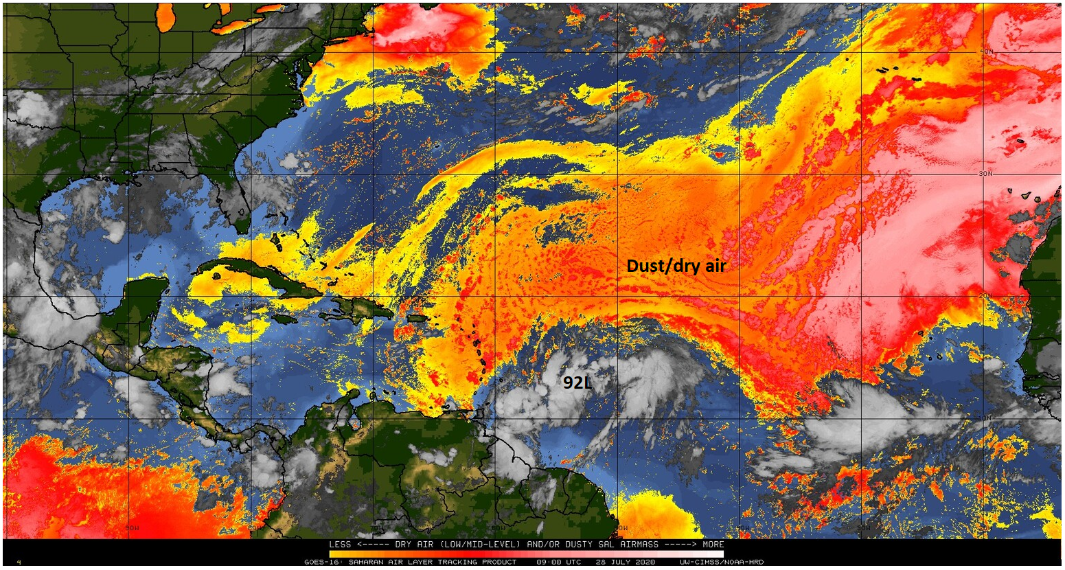
PTC 9 has some hurdles ahead. A look at the satellite image from this morning shows a lot of “stuff,” but not a lot of healthy organization right now.
Potential Tropical Cyclone 9 has a lot of thunderstorms associated with it as of this morning, but it remains mostly disorganized. (Weathernerds.org)
That shouldn’t minimize it as something to watch, but given how things have gone in recent years, it’s nice to see a disturbance struggling to organize. One of PTC 9’s problems is that it has a large size. It’s a lot easier to spin up a smaller system that grows, but this one covers a large chunk of real estate already, so to get it started requires some effort. The other problem is that there are multiple clusters of thunderstorms within the broader circulation, any of which could become dominant. That obviously has implications on the long-term track.
The disturbance is also surrounded by a lot of dust and dry air.
PTC 9 has dust or dry air to content with on its west, north, and east flanks. (University of Wisconsin CIMSS)
The problem here from a forecast standpoint is that since we don’t know where in this broad circulation the thunderstorms will consolidate to help develop a defined tropical depression or storm. we cannot quite give you a definitive starting point. Without a solid starting point, forecast accuracy 3, 5, or 7 days from now will obviously suffer.
What we can tell you is that PTC 9 has hurdles in front of it. Between the dry air, a likely encounter with a weak trough in the Bahamas Friday, and another, stronger trough over the Southern U.S. next week, as well as any land interaction on its way west, it will need to overcome some challenges and insulate itself from these threats or else it will struggle to develop.
That said, anything from where the system consolidates to how strong these troughs and other features actually are (compared to what they’re currently forecast to be) could impact where PTC 9 goes and how strong it is. For now, the best advice with this system is to not worry about it (we’re certainly not), but check back in on it every day or two to see what has changed.
And for those of you wondering, if we do get a storm out of this one, it will be named Isaias, and pronounced:
Things get complicated beyond PTC 9/Isaias. Intriguingly, there are no other systems showing up on the models with any frequency or confidence right now. This is implying that we may enter a quiet stretch for a time again. There’s some background support for this as a feature that typically helps suppress storm development should move through the Atlantic Basin this week. On the flip side, the 2020 M.O. has been for random stuff to flare up seemingly out of nowhere. So in that sense, it’s tough to argue a quiet period.
Whatever the case, I do think we will have a slightly quieter stretch post-Isaias, with the risk of a more significant ramp up in activity by the middle or late portion of August.
Good morning. We’re entering a summertime pattern where showers will be possible on most days, but rainfall by no means a certainty. For late July and August, our weather during the coming week will actually run on something of an even keel, with temperatures neither too hot or cold for this time of year, and neither a blistering drought nor flooding rainfall. We’ll take it.
Tuesday
Today will probably bring the best chance of widespread rain and heavy showers as an upper-level low pressure system passes slowly overhead toward the southwest. This should initiate showers during the late morning hours into the late afternoon or early evening. Areal coverage will probably be about 50 percent. As we saw on Monday, some of these storms should be pretty efficient lightning generators. Highs may rise into the low 90s this afternoon with partly sunny skies, and winds will be light out of the south. Overnight lows Tuesday night will be similar to those for the rest of the week—upper 70s for inland areas and lower 80s for the coast.
Map of lightning strikes on Monday and Monday night. (Lightningmaps.org)
Wednesday
Wednesday will again bring a healthy chance of showers. However, with the upper-level low moving away we should see less organization in any storms that form, and probably fewer thunderstorms. Otherwise, skies will be partly sunny and highs in the low 90s.