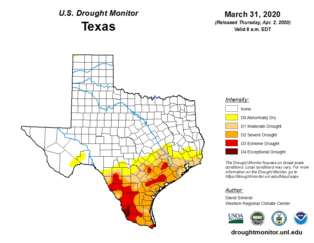
Good morning. All in all, it ended up being a pretty darn nice weekend in Houston. On Friday and Saturday, much of the region got 1 to 2 inches of rainfall. We haven’t talked about it too much here, but the rainfall was really needed with much of the region under a moderate-to-severe drought (see below), and more warm weather on the way. Then, Sunday, was a pleasant spring-like day with a cool start and more sunshine that we originally expected. So, all-in-all, a good couple of days.
Drought conditions in Texas. (U.S. Drought Monitor)
Monday
The weak front that pushed into Houston this weekend is pulling back to the north, and this will help introduce a slight chance of showers into the forecast today. But mostly, skies will simply be cloudy, with rising humidity levels, and temperatures near 80 degrees. Winds will turn from the north to southeast throughout the day, remaining fairly light. Don’t expect much of a cool down Monday night, as insulating clouds and the warmer flow will keep lows at about 70 degrees.
Tuesday
This day will be a lot like Monday, albeit a few degrees warmer, with highs edging into the mid-80s. Again, we’ll see the possibility for some scattered showers and thunderstorms in the absence of high pressure. Expect another warmer night.
Rainfall has been a challenge at times since late 2019 across the area. We are finally beginning to transition into true spring here, and April showers will bring most of us a decent helping of rain over the next few days.
I’m going to do this post a little different than we usually do today, partly to make it easier to explain what we’re watching and when.
Quick synopsis
Today: Showers and thunderstorms develop north and west of Houston. Severe weather is possible west of our area, with lower chances as you get closer to the Houston Metro.
Tonight: Showers and storms drop south and east into the Houston area this evening. Some storms could be strong to severe, especially west of Katy or Cypress. Heavy rain is possible, mainly early.
Saturday: Showers and thunderstorms possible at any time through the day, possibly most concentrated near sunrise and again in late afternoon. Heavy rain possible, especially south of Houston. Severe weather is not likely. Cooler.
Saturday night: Showers and thunderstorms possible, mainly in the evening hours, diminishing overnight.
Sunday: Showers possible, but likely a much calmer day.
Severe weather
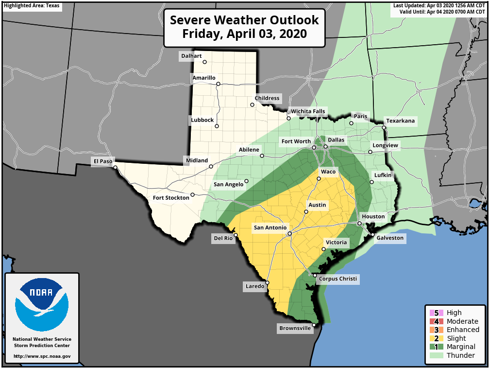
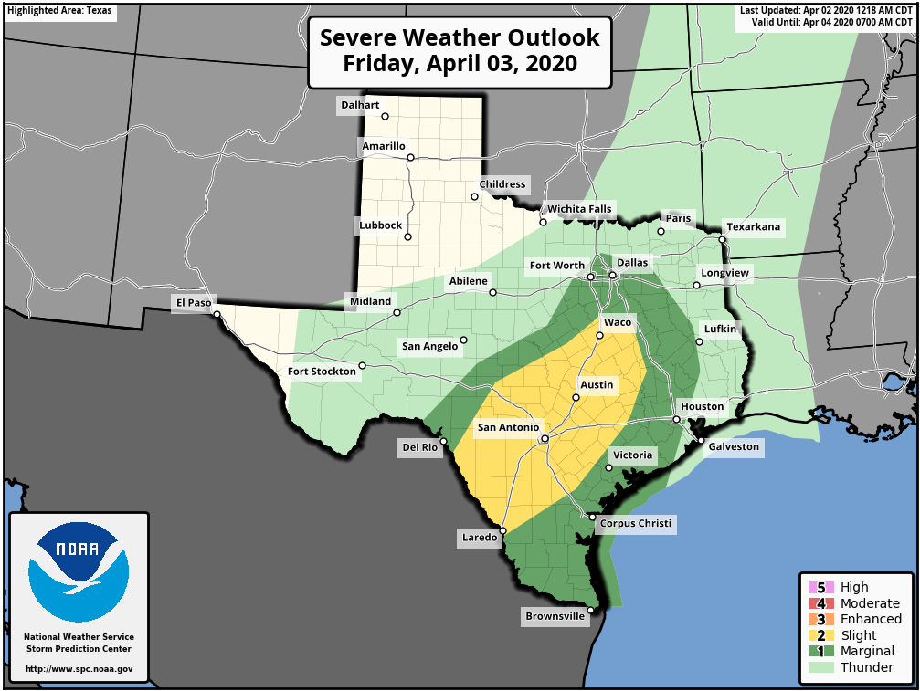
Now, we’ll walk you through the various concerns of this event. Let’s start with the severe weather aspect, because that seems to be what we get the most questions about. The Storm Prediction Center has highlighted areas mainly northwest of Houston today for the risk of severe storms.
Severe weather, especially large hail or strong wind gusts will be most likely toward Austin or San Antonio today. Some of those storms could get into western parts of the Houston area by evening. (NOAA)
The highest risks today will likely be 1.) hail and 2.) wind. Storms will be capable of some big hail, especially as you go west of Houston and closer to San Antonio and south of there toward Laredo. Strong wind gusts will be possible if the storms can organize more into “lines” at some point, and I expect that would be the primary thing to watch for the west side of Houston. We could see a line of storms approach by evening, which would be capable of those strong winds. As severe weather events in Houston go, this one doesn’t look especially serious, but as always, it’s something we will monitor.
Heavy rainfall/flash flooding
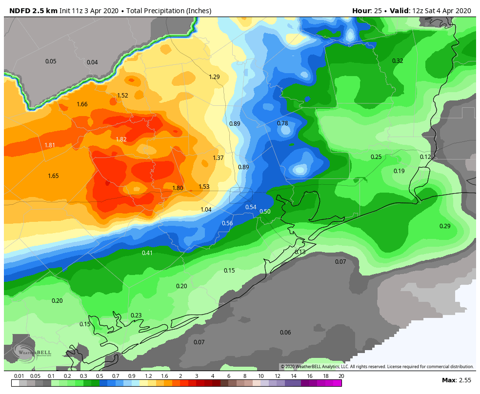
It is no secret that it has been dry in parts of our area in recent months. This is especially true as you go south and west of Houston. While Houston has seen roughly 50 to 75 percent of normal rainfall in 2020, places like Victoria and Corpus Christi have seen even less, more like 25 to 50 percent of normal. Thankfully, that provides us a little padding to absorb some of the initial heavy rains from this event. In general, heavy rainfall is likely in spots this evening, especially north of I-10 and west of I-45 initially. That could transition a bit south and east of there as the evening goes on, but storms would likely begin to weaken and rainfall rates should slow a bit. We should be able to handle today and tonight’s first wave with nothing worse than some minor street flooding or ponding on roadways.
Total rainfall by 7 AM Saturday should be heaviest off to the north and west of Houston, with some places south and east seeing little to no rain by this point. (Weather Bell)
Overall, rains should slow overnight and possibly fizzle out as they get closer to the coast.
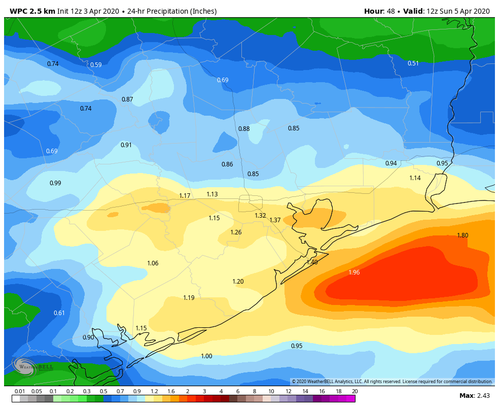
Saturday’s rain will focus farther south than what we see today. The front will likely be through Houston (more on that below), which means showery weather should dominate much of the day. Closer to the front and coast, we should see thunderstorms try to develop, and that’s where heavier rain would be most likely late Saturday afternoon and evening.
Additional rainfall forecast between 7 AM Saturday and 7 AM Sunday will focus south and east of Houston. (Weather Bell)
Total rainfall when all is said and done Sunday morning should be on the order of 0.5 to 1.5 inches on average, with higher amounts, closer to 2 or 3 inches in spots, especially north and west of Houston or closer to Galveston and Matagorda. A quick note on Galveston: With elevated tides expected this weekend, you might notice slower drainage than usual. Most folks will be staying at home anyway, but if you do have to venture out late tomorrow, just keep that in mind.
Well Houston, you were promised two days of beautiful, spring-like weather. Now that you’ve had them we’re heading back to a more moist, warm period through this weekend and most of next week. Let’s put it this way—we’re unlikely to see the 50s in Houston again until at least the weekend of April 11th. The bigger news, for now, is the likelihood of a wet weekend.
Thursday
Temperatures are starting out in the 60s this morning, and should warm into the mid- to upper-70s. Highs will depend in part on cloud cover, and if you see a few slivers of sunshine this afternoon it will make things a little bit warmer. Scattered light to moderate rain showers will be possible this afternoon and evening, especially north of Interstate 10, but we don’t expect anything too impactful. Winds will be mostly light, out of the southeast at 10 mph or less. Low temperatures tonight will probably fall down only to around 70 for most.
Severe weather outlook for Friday. (NOAA)
Friday
This will be another day like Thursday, albeit with a little bit better rain chances, and temperatures perhaps rising a little closer to 80 degrees during the day time. Friday night will be warm again, with a modest chance of thunderstorms, again with the best chances north and west of downtown Houston. The strongest thunderstorms should remain to the west of Harris County, near a slow-moving cold front as shown in NOAA’s severe weather outlook above.
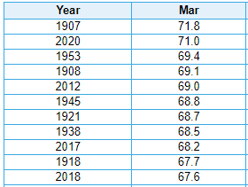
As Eric noted on Monday, March was a remarkable month this year for how warm it was in Houston. But it was not quite like March 1907, which will remain atop the leaderboard for warmest March in Houston’s recorded history.
Three of Houston’s top 10 warmest Marches have occurred in the last four years. None could beat March of 1907. (NOAA)
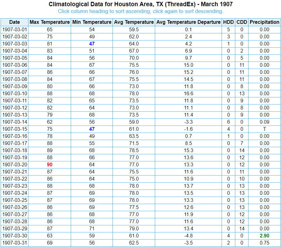
Cast your mind back more than a century ago. In 1907 Houston was but a town, with roughly 60,000 residents. Whereas today Houston is the fourth largest city in the United States, it was nowhere near the top 10 rankings of most populated cities of that era.
March 1907’s daily weather. The month started pretty warm and just kept going from there. (NOAA)
There was little about March 1907 that was cool in Houston. More than half of the month (16 days) saw low temperatures of 65° or warmer, a record for any March. Over the last 10 years, in a warm climate, in a much more robustly developed Houston, we have only averaged 6 to 7 mornings that warm in March. This year’s March is the closest to rival that since 1955, matching that year’s 14 days of not dropping below 65 degrees.
Houston only had one 90 degree day in March 1907, but the city recorded 15 days above 85 degrees that year, which is far and away the record for any March. The next closest are 1908 and 2017 when we accomplished that feat a mere 8 times. This year’s March only saw 5 days above 85 degrees.