Quick note: If you were woken up by or heard/felt an explosion this morning, you were one of many. There was indeed an explosion northwest of Houston near the intersection of Gessner and Clay Road. This is just south of 290 and east of the Beltway. As is often the case in situations like this, weather radar picked up the actual explosion or fire.
Explosion in NW Houston…radar picked up a return near the location at the same time #houwx #hounews pic.twitter.com/Sk8kqztPbo
— Jeff Lindner (@JeffLindner1) January 24, 2020
I’ve seen people as far away as Clear Lake hearing the explosion. We send our best to readers in that part of the area that may be cleaning up this morning. An unfortunate morning northwest of Houston.
On to weather, we are back into a really nice pattern today, but we do have a couple minor issues to discuss for the weekend.
Today
Friday should be a beautiful day with sun, light winds, and highs reaching into about the mid 60s.
Saturday
While I believe we will start out with sunshine, high clouds should begin moving into the region in the morning. The day will get progressively cloudier from there. Clouds thicken up in the afternoon, and at least a slight chance of light rain or some showers will begin by late afternoon. The best chance for seeing some of that rain during the daytime hours will be south of Houston, particularly from Freeport south through Matagorda Bay. Most areas north of Houston will likely remain dry during the daytime Saturday. Temperatures will warm from the mid or upper 40s in the morning to the mid 60s or so in the afternoon.
Saturday night & Sunday
From Saturday evening through Sunday morning, it will be fairly dreary across the region. Look for periods of mostly light rain and showers. A brief period of heavier rain cannot be entirely ruled out, especially along the coast. So if you placed an “X” over downtown Houston, areas to the south and east of there have the chance to see some higher rain totals. Inland from Houston, the odds drop off for seeing anything heavy.
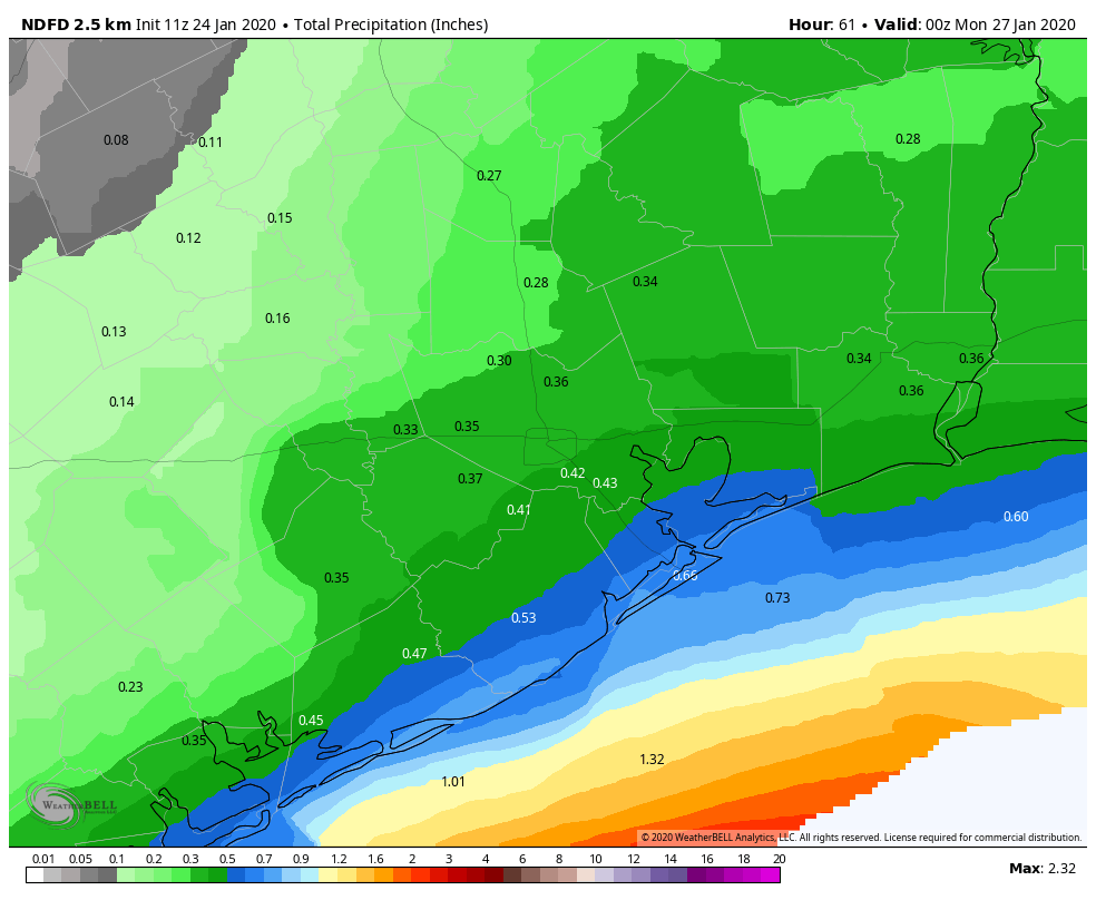
Regardless, no serious flooding is expected, and rainfall totals should be manageable across the vast majority of the region. It will just be a fairly dreary Saturday night and Sunday.