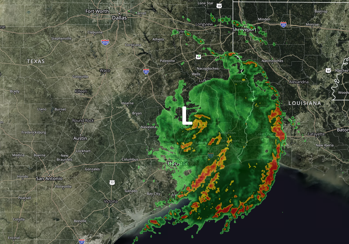
As of midday Wednesday, we’re starting to feel pretty good about the chance of Houston avoiding significant flooding from the remnants of Tropical Storm Imelda. We’re not entirely in the clear, to be sure, but the threat is shifting east away from the metro area. First of all, let’s take a big picture look at the radar at Noon.
Radar image at noon CT. (kktv.com/Space City Weather)
As you can see, Imelda’s remains are producing a very broad circulation, with several distinct banding features from along the Texas coast to well into Louisiana and northeast Texas. Houston residents will also take note that these strongest bands are generally moving away from the metro area.
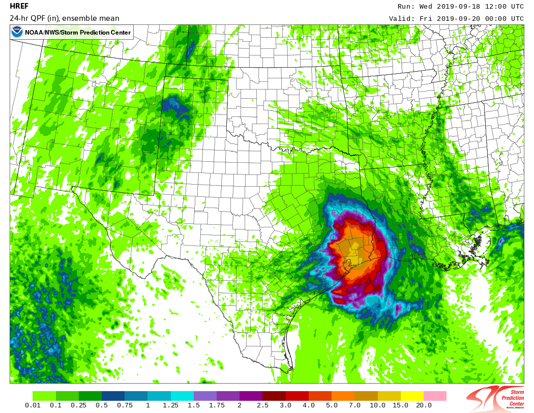
Based upon the latest modeling trends, we expect this trend to continue today. While the Houston metro area may see an additional 1 to 4 inches of rainfall over the rest of Wednesday and through Thursday (especially to the east of Interstate 45), the threat of sustained, heavy, and flooding rainfall is diminishing. We can see this based upon the HREF model output, which is an ensemble of several models that attempt to predict smaller-scale convection during rainfall events. Of all the models we’ve looked at so far during this event, the HREF has arguably done the best. Here is its output for now through Thursday.
HREF ensemble forecast for rain accumulation from midday Wednesday through Thursday evening. (NOAA)
The bottom line is that right now we expect the Houston region, including hard hit areas in Brazoria and Galveston counties, to generally see improving conditions from here on forward. Intermittent storms may well pop up, but right now, we anticipate that most areas can safely return to business-as-usual activities. For areas east of Houston through Beaumont, however, we definitely have concerns about ongoing heavy rainfall, and will continue to monitor that situation.
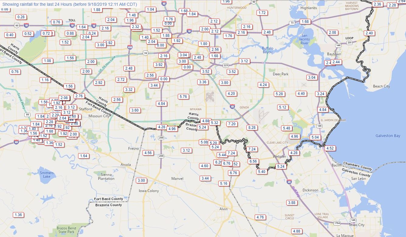
Let’s begin this morning’s post with a quick look at 24-hour rain totals for the broader southeast Texas region. Imelda moved inland near Freeport on Tuesday, meandered up toward Sugar Land, and is now near, or just west of The Woodlands. Since that time the storm has brought a devastating amount of rainfall to coastal Brazoria County (nearly 20 inches in some locations), and upwards of 8 inches or more for places to the right of the storm’s track near Alvin, Friendswood, Pearland, and Clear Lake.
24-hour rain totals from Tuesday morning through Wednesday morning. (TexMesoNet)
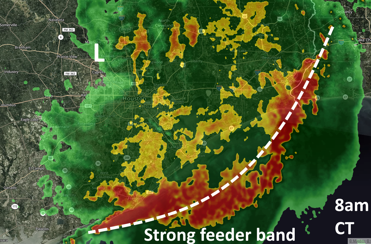
So what comes next? Imelda’s heaviest rains are continuing well to the south and east of the storm’s center, with much of the most intense rainfall just offshore. (This is good, because an area near Sargent recorded a 5-inch hourly rainfall rate last night).
This intense coastal band is, at present, capturing the deeper flow of Gulf moisture before it can move inland. Long story short, the band highlighted in the radar map below is effectively a shield this morning preventing heavy rainfall over the central Houston area.
Houston radar at 8am CT Wednesday. (kktv.com/Space City Weather)
Beyond this morning, however, we’re kind of flying blind as to where storms will redevelop later this afternoon and evening. Sometime later today the feeder band shown above should have broken down, and along with some daytime heating we can probably expect storms to re-form over inland areas. But whether that’s over Clear Lake, downtown Houston, or points east is pretty hard to determine. Our short-range modeling does a pretty poor job during these kinds of situations. If you want my best guess—and this really is a guess—we’ll see some kind of mass of storms form over the central Houston area this afternoon or early evening, and then push into Liberty County later tonight. These could be relatively moderate storms, or quite intense.
For now, at least, Imelda looks to be manageable for all of the region except for the immediate coast, as well as flooding along Clear Creek to the southeast of Houston. More later.
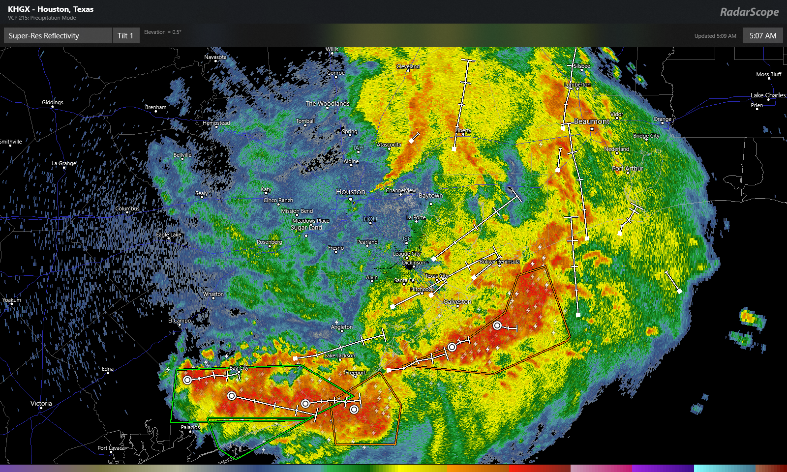
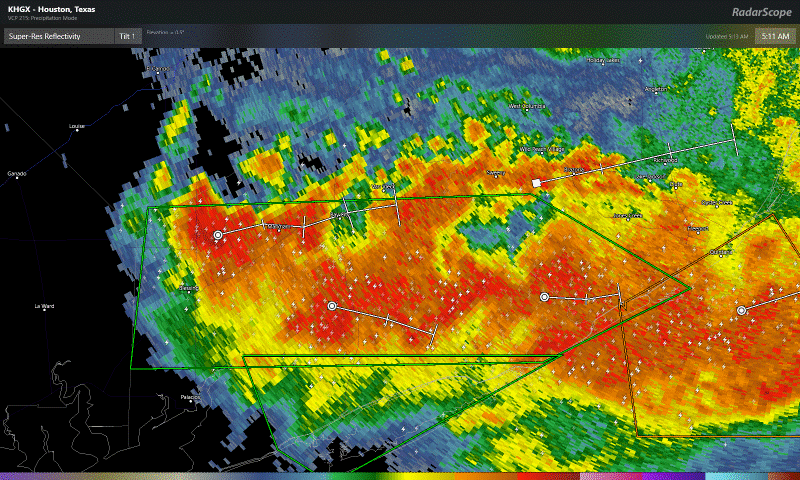
Good morning. For most of the city of Houston and points north and west, overnight rainfall caused few problems and has really only served to saturate soils a bit. Imelda’s dissipation has allowed for one main band to focus this morning well to our south into Matagorda County, which then arcs offshore back inland east of Galveston and Bolivar, aimed primarily at the Beaumont area.
Radar this morning shows extremely heavy rain well south of Houston and east of Houston, along with a smaller band northeast of downtown Houston. (RadarScope)
The radar snapshot above from just after 5 AM shows limited heavy rain around Houston, with one narrow band extending from northeast of downtown into Liberty County.
Focusing a little closer on Matagorda County for a moment: This band means business.
Rainfall rates of 3″ to 5″ in an hour were being observed in parts of Matagorda County this morning. Flash flooding is likely there. (RadarScope)
Rainfall in the hour prior to my writing this post was over 5 inches (!) in parts of the county. A gauge near Sargent has received over 18 inches of rain in the last 24 hours. Those are extreme rainfall rates that will quickly cause flash flooding in that area. Travel across much of Matagorda County is not advised this morning, and it will likely get a bit worse before it gets better. These beefier rainfall rates will likely push into southern Brazoria County as well, so folks from Lake Jackson and Freeport through Surfside will probably want to use caution this morning as well.
Rest of today
So the million dollar question is: Where is this going? Saving the meteorology lesson for another day, we often see blow ups like this in tropical systems late at night and in the morning. Over the next few hours, this will probably yield areas of heavy rainfall across Matagorda, Brazoria, and Galveston Counties. Given that many of these locations have seen 4 to 9 inches since yesterday, it won’t take much for flash flooding to begin if rainfall rates are intense enough. Rainfall may begin to taper off this afternoon or shift more to the east toward Beaumont or Port Arthur. We do expect some new showers and thunderstorms to develop in and around Houston by later this afternoon. More on that in a moment.
Bottom line: What should you do today? Be cautious, but most of us can go about most of our day as usual (unless you’re down in southern Brazoria and Matagorda Counties as noted above). If you live southeast of Houston, be extra vigilant in case rain rates escalate a bit this morning. Eric will update you on the progress of that a bit later. In Houston and points north and west, I think most daily activities will be fine through 3 to 4 PM, though it will be raining at times. After 3 to 4 PM, things could begin to go downhill a bit. Given all this, if you work daytime shifts and can work your way home a little earlier than usual today, that would not be the worst thing in the world.
Tonight
All along, it appeared tonight would be the “main event” so to speak for the Houston area. Look for storms to begin to show up around 3 to 4 PM or so in and around Houston. Some of the storms will be heavy with impressive rainfall rates. As we work through the evening, I think the general trend will allow for those storms to slowly lift north and east, while becoming more numerous. For Houston, the hope is that the storms will lift out quickly enough to limit significant problems. We would then see the heaviest rain tonight up into Liberty County or point northeast from there. There is still a good deal of uncertainty regarding tonight’s forecast, so be sure to check back with us later today for an update when we should hopefully know more. It could get a bit rough this evening, but we’re hoping for the best possible outcome right now.
We still see rain becoming more scattered tomorrow and Friday, with a mostly dry weekend expected. Eric has you covered a little later this morning.
For much of the Houston area, the first day of widespread rainfall from the tropical storm formerly known as Imelda has been mostly a non-issue. Large swaths of the metro area north of Interstate 10 have received less than one-half an inch of rainfall. Count yourselves lucky. Parts of southern Brazoria County, as well as the Alvin, Clear Lake, Pearland, and Friendswood areas have received 6 to 8 inches of rainfall over the last 24 hours. Soils south of Houston are sodden, and some stretches of Clear Creek are nearing their bankfulls.
24-hour rainfall totals for Tuesday. (HCOEM)
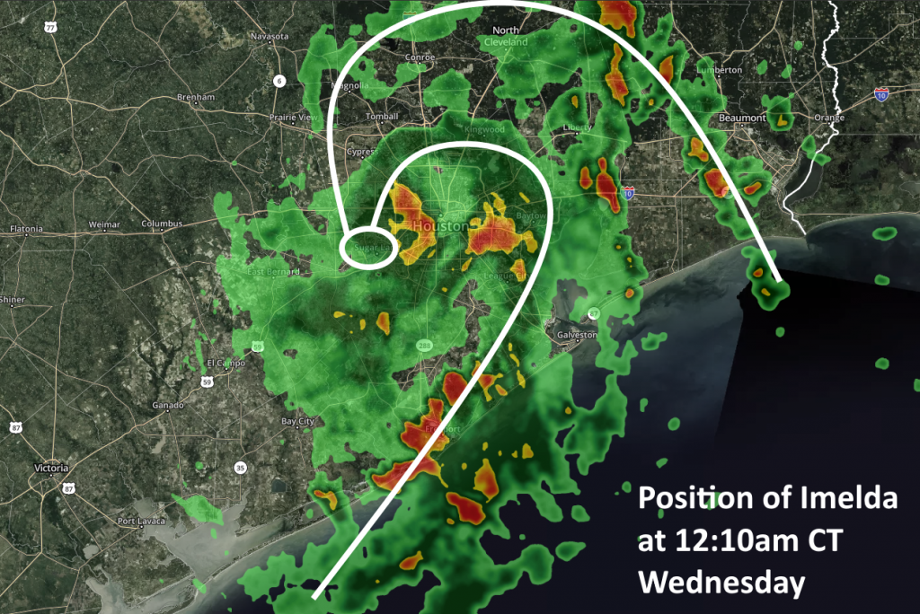
As of shortly after midnight, Imelda’s “center” appears to have moved almost directly over Sugar Land as it slowly wobbles northward across the Houston metro area. This “drunken sailor” motion will probably continue for the next day or so as the system slowly lifts northward. Looking at the radar at this time, there are several clusters of fairly heavy showers and thunderstorms, particularly right along the coast, moving from Brazoria County toward Galveston County.
Imelda’s position as of 12:10am CT Wednesday. (kktv.com/Space City Weather)
But fortunately we have yet to see the really intense rainfall rates of 2.5 to 5 inches per hour that can quickly back up bayous, roads, and flood yards. For the rest of the night, some of the high resolution models are continuing to show rain showers really blowing up between midnight and mid-morning Wednesday, but so far we’re not seeing that really verify on radar. However, the scencario remains plausible given the highly efficient moisture transfer by Imelda from the Gulf inland, along with plenty of atmospheric instability. The biggest area for concern is probably south and east of Interstate 69 for the rest of the night.
As for Wednesday and Thursday, both days will have the potential for heavy rainfall. Hard to say which has the higher potential, but for now I’d probably go with Wednesday as the system should really begin to pull away from Houston on Thursday.