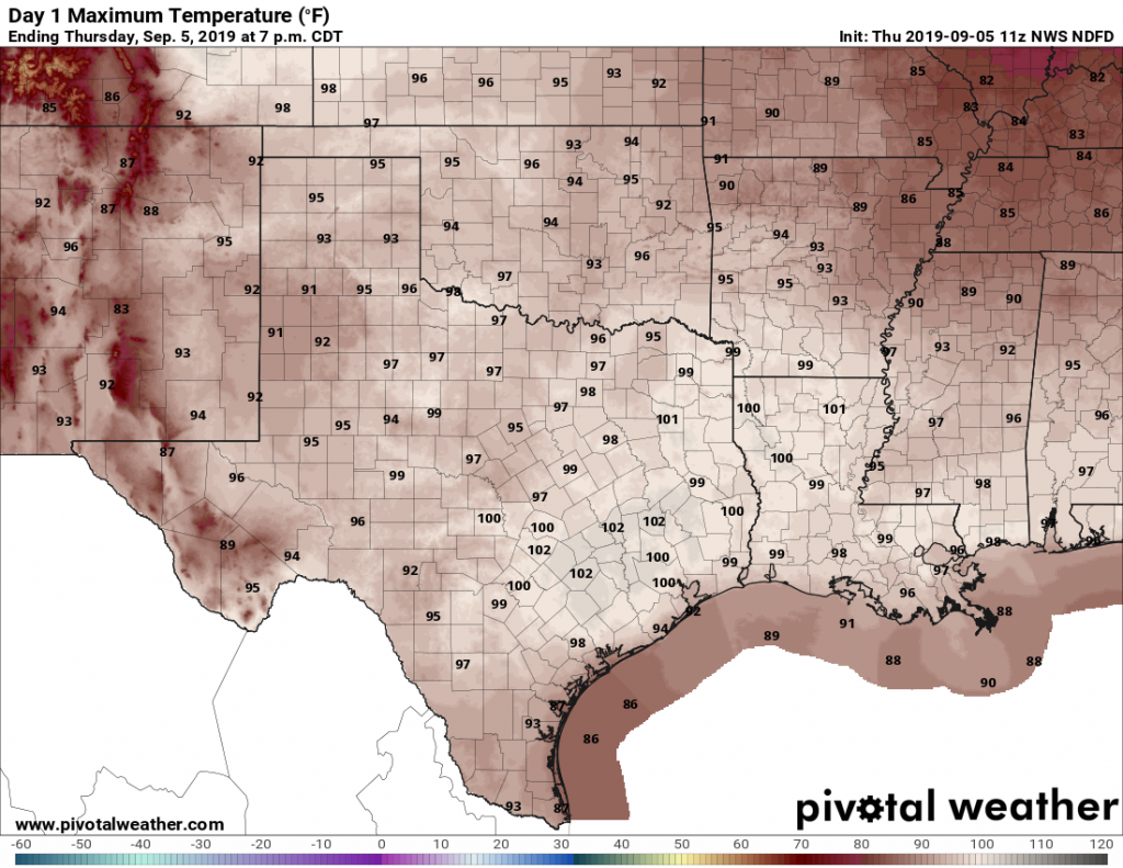
Houston’s torrid late-summer weather will unfortunately continue, as expected, for the rest of the week. On Wednesday, the high temperature reached 99 degrees, and that’s pretty much the floor for what we can expect from maximum temperatures the rest of this week. By Friday, we’re likely to break a 110-year-old high temperature record.
Thursday
We will not touch the record high for Houston today, which is 108 degrees. If you lived in Houston, in 2000, you may remember the extraordinary heat wave of early September that year—this was the tail end of that period. Rather, Houston’s highs will “only” get up to around 100 degrees on Thursday as high pressure dominates the region. Rain chances are non-existent. Humidity will be a smidge below typical summer levels, which is about the only good thing that can be said about this heat.
The heat is on, y’all. (Pivotal Weather)
Friday
The high record for Friday is 99 degrees, set way back in 1909. We are very, very likely to beat that as Friday’s highs should get into the low 100s for most of the city. You’ll note new banners from Reliant on today’s post—it’s because the late summer heat is putting a strain on the state’s electricity grid. Please conserve energy if possible during the hottest part of the day.
As the tropics heat up all around Texas—with Tropical Storm Fernand moving into Mexico and Hurricane Dorian threatening the southeastern United States—the big local concern is actually an emerging drought. With extremely hot and sunny weather forecast for awhile in Houston, a moderate drought could return to the region for the first time in nearly three years. We’re going to discuss that at the end of today’s post.
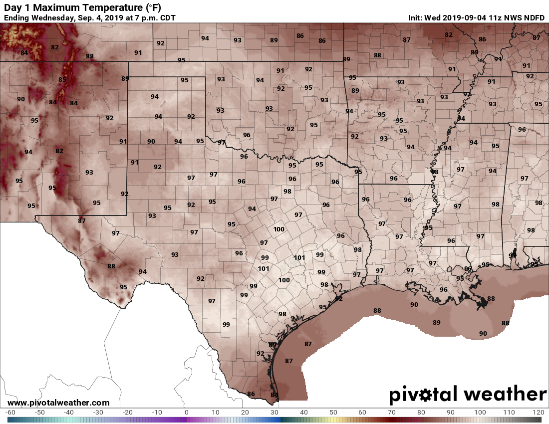
The heat will be on for Wednesday. (Pivotal Weather)
Wednesday through Friday
The forecast is more or less the same for the rest of the work week, with building high pressure over the state of Texas. We are going to see high temperatures near or at 100 degrees, lows around 80 degrees, and rain chances of effectively zero percent. The air mass will be a little drier than normal for “summer,” so the heat index won’t be quite as high as it was in August, but it’s still going to be really, really hot. We probably will set some daily high temperature records this week.
Saturday and Sunday
At this point, the weekend should bring more of the same. Make your beach or other outdoor plans with confidence.
Next week
High pressure should finally back off early next week, allowing for more moisture to work its way inland from the Gulf of Mexico. This should lead to the development of more clouds, along with some decent rain chances. But don’t expect too much. The global model ensembles, on average, forecast about one-half inch of rain for all of next week. Temperatures should drop back into the low- or mid-90s. Alas, there remains nary a whiff of a cold front in the models, sorry.
August may be over, but the heat will remain for Houston as a late-summer ridge of high pressure settles in over the region. There are no cold fronts in sight, alas. Meanwhile, the Atlantic season’s fifth tropical storm is forming in the southern Gulf of Mexico (it is no threat to Houston) and Hurricane Dorian has absolutely ravaged the northern Bahamas. We’ve got a lot to get to today.
Monday
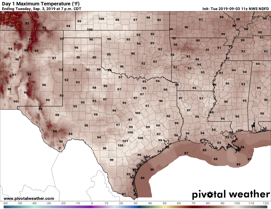
There are no bones about it, today and the rest of the week will be hot beneath a ridge of high pressure. Coastal counties, such as Galveston and Brazoria, may see some showers today from the very outer bands of the tropical system deep in the Southern Gulf of Mexico, but most of the region will be hot and sunny, with highs near 100 degrees. Lows tonight will be near 80.
A hot day Monday in Texas. (Pivotal Weather)
Tuesday through the weekend
To be honest, the weather is not going to change a whole lot for Houston this week. We’re going to remain in this high-pressure driven hot-and-sunny pattern, with highs near or at 100 degrees for the remainder of this week, and likely through the weekend. Rain chances will be near zero, as we start to have some drought concerns.
Heat, how long?
The heat wave may finally break early next week, as highs fall back to more normal temperatures in the low- to mid-90s. However, the chances of a cold front during the first half of September appear to be quite remote.
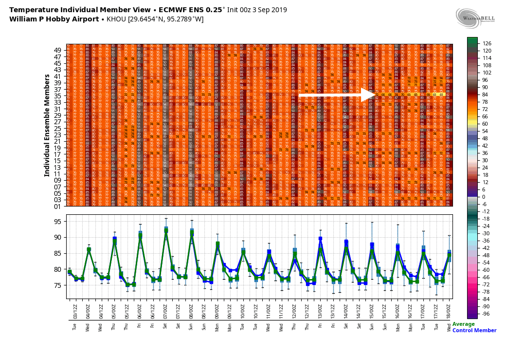
Here’s the one European ensemble member that predicts a cold front. (Weather Bell)
Here’s the latest ensemble output from the European model for low temperatures through September 17. Just one member out of 50 (!) brings a notable front into Houston during that time. These are not, uhhh, good odds.
Note: This post will cover Hurricane Dorian, which presents no threat to Texas, but which we are covering due to general public interest. For Houston, there are no tropical threats for the foreseeable future. It just looks very hot with diminishing rain chances over the coming days. Our normal posts will resume tomorrow.
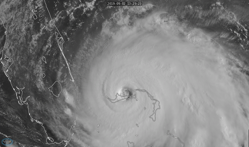
Hurricane Dorian has unleashed utter fury on the northern Bahamas over the last 24 hours. Great Abaco and Marsh Harbour took a direct hit yesterday while Dorian was at its peak intensity. Grand Bahama Island was hit directly overnight, and the storm’s forward motion has slowed to approximately 1 mph with the center about 30 miles northeast of Freeport.
Dorian is expected to gradually weaken a bit through the day today, though it will remain an exceptionally dangerous storm, likely of at least category 4 intensity. We are seeing signs of a possible eyewall replacement cycle underway though, which should allow the storm’s maximum winds to weaken, while the size of the wind field expands a bit. Dorian will fluctuate in intensity over the next day or two before beginning a more steady weakening trend as it lifts north later in the week.
Where is Dorian going?
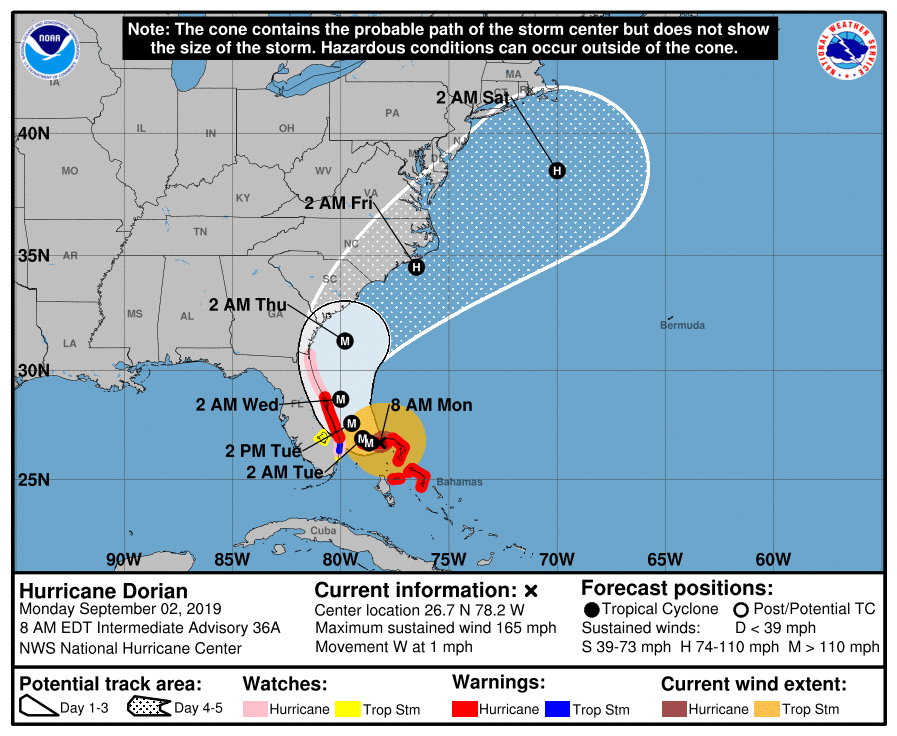
Dorian’s official track forecast keeps some portion of the Florida coast in the cone, but the storm is still expected to track just offshore. (National Hurricane Center)
That remains a tricky question, but the good news if you live in Florida is that everything is basically happening the way it was expected to happen in terms of track as of this morning. Anytime a storm slows to 1 mph, there is some inherent uncertainty in the details of a track forecast. But weather modeling is almost entirely on board with a track very similar to Hurricane Matthew in 2016, as it moves up the coast just offshore of Florida, Georgia, and the Carolinas.
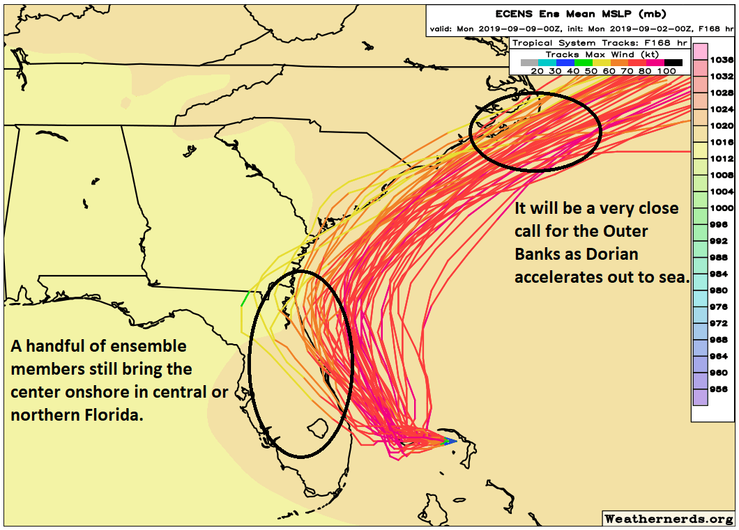
Dorian will be a close call in Florida and up the coast, but the vast majority of data keeps the center just offshore. (Weathernerds.org)
The latest European ensemble forecast from overnight is shown above. Again, this is just the European model run 51 different times with some tweaks in initial conditions to give a better idea of goalposts in the forecast. A few things to note. First, of the 51 ensemble members, there are still around 8 to 10 that bring the center onshore near Cape Canaveral or just south of there. While the odds aren’t high, they aren’t zero, so folks in Florida still need to be prepared. Even assuming the track stays 25 to 50 miles offshore as expected, that will still be close enough to deliver strong winds, surge, and plentiful beach erosion to the entire coast. Remember, Matthew took a similar track, and although no two storms are alike, it underscores that severe impacts can still occur without a landfall. The Florida coast will need to hunker down tomorrow through Wednesday.
As Dorian treks northward, finding its way between the high pressure over Texas and the one in the Atlantic, it will begin to accelerate. Again, this will be close to the coasts of Georgia and South Carolina, though probably still offshore. As it passes North Carolina, there will be some chance of a landfall near Cape Fear or Cape Hatteras as the storm passes. Folks in the Carolinas and Georgia should prepare for significant coastal impacts, as well as heavy rain. Again, as we saw during Matthew in these areas, significant impacts can still occur far from the actual center.
Dorian should finally exit at the end of this week, and hopefully we see no more threats to land masses for a bit.