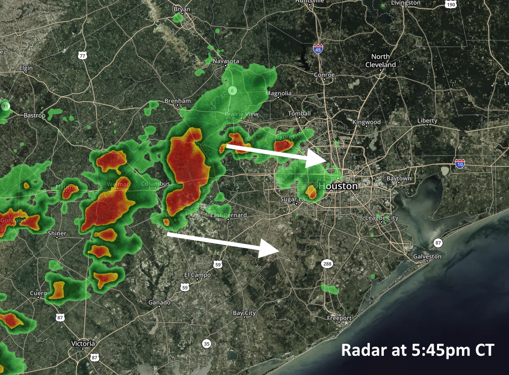
A few warm, wet days, then an extended period of cooler weather

Good morning. We’ve kicked off our annual fundraiser for the year, and it will last for the next three weeks. We don’t want anyone to feel pressured to contribute anything, but readers often ask how they can help the site.

Main t-shirt design for 2018.

So once a year we sell t-shirts (as well as sweatshirts and umbrellas this year) and accept donations via Custom Ink. The money goes to support our operating expenses—zero server problems in 2018, yay!—and support the considerable time that Matt and I spend at this. Now, onto the forecast.

Tuesday

Fog has developed over the region, especially western Houston, but it should lift by around 9 or 10am this morning. After this we should see partly sunny skies and another fairly warm day for early November, with highs in the low- to mid-80s. Humidity will be abundant as well. Rain, for the most, part, should hold off but we may see a few scattered showers across the area. Expect a steamy November night, with most of the city not falling below 70 degrees.

Wednesday

Another warm day, with highs in the mid-80s, but as moisture levels pile up we’ll see better rain chances across the area. For the most part, this should be light to moderate rain, but we can’t rule out a few thunderstorms. I expect accumulations, at most, in the tenths of an inch. Nighttime temperatures will be slightly cooler, but still in the 60s inland, and low 70s along the coast.

See full post

A gray and warmer week before a clear and cool weekend

After a pretty nice weekend—Sunday morning’s showers aside—our weather will turn warmer and more humid this week before a strong front arrives before next weekend. We’re not looking at anything too extreme, but we can definitely anticipate some showers and thunderstorms on Thursday and Friday.

Monday

The weak cold front that pushed into the offshore waters on Sunday is moving back onshore today, and we’ll feel that later this afternoon in the form of stronger southerly winds and rising humidity. Expect highs in the low 80s, with mostly cloudy skies. A word of warning if you’re traveling up into east Texas or Arkansas today, as that area faces the potential for some severe weather due to a separate frontal system. Rain chances should be near zero in the Houston metro area itself.

Severe storm outlook for Monday and Monday night. (NOAA)

Tuesday

Another warm day, with high temperatures in the low to mid-80s, depending upon the extent of afternoon sunshine in your area. Highs will probably be 8 to 10 degrees warmer than normal for this time of year, but the heat won’t last too long. Rain chances will be in the 10 to 20 percent range.

See full post

A 50/50 weekend ahead, questions next week

Just to tie a bow around Wednesday night’s cold front and severe weather: An EF-1 tornado was confirmed in Chambers County.

There was also a tornado in Colorado County near the Wharton County line. Texas City and Garden Oaks had straight line wind damage confirmed. The NWS was unable to confirm damage around Sealy, Katy, or Sugar Land, so they do not believe a tornado occurred in those locations at least as of Friday morning. More storm reports can be found here.

Today & Saturday

Today is our first morning officially in the 40s since April 16 of this year. We’ve hit at least 49° at Bush Airport as of 5:30 AM. We’re setup for a beautiful start to the weekend. Look for plenty of sunshine today and a little less wind than we saw on Thursday. High temperatures will rebound from our cool start into the upper-60s or low-70s.

Saturday begins our transition out of this autumn weather. Look for mainly sunny conditions again, but onshore flow will gradually develop through the day. We will start on a cool note with some scattered 40s well outside of Houston, but mainly low-to mid-50s for most. We’ll warm several degrees over Friday during the afternoon, with highs topping off generally in the mid-70s.

See full post

Houston trades storms for splendid fall weather—for a few days

Well, that’s all over. We survived Wednesday afternoon’s storms, the rains ended long enough for most people to do some trick-or-treating, and then a strong front blew through Wednesday night. The squall line of storms produced wind gusts of up to 50mph along the coast. Rain totals over the last 24 hours were impressive, too, ranging from about 1.5 to 4.5 inches, enough to cause some street flooding, but those concerns are ending now with drier air moving into the area, behind the front. Some splendid weather lies ahead.

Thursday

It’s chilly outside this morning, so don’t forget to bring a light jacket. Temperatures are generally hovering around 60 degrees in the city, with a brisk northerly wind at around 15 mph. Highs won’t rise too much, probably into the upper 60s, even as skies clear later today. All of this colder, drier air moving into the region should bring Houston its coldest night of the season on Thursday night, with inland areas likely seeing low temperatures in the 40s.

Houston should see its coldest temperatures of the season on Friday morning. (Weather Bell)

Friday

This should be an amazing day, with a cool start, sunny skies, and high temperatures of around 70 degrees for the most part. We’ll see another chilly night on Friday into Saturday morning, but overnight temperatures will be a few degrees warmer across the area.

See full post