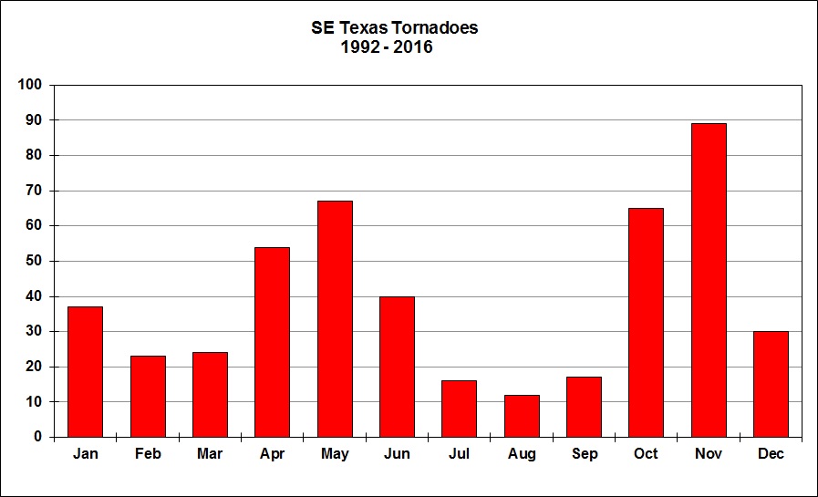
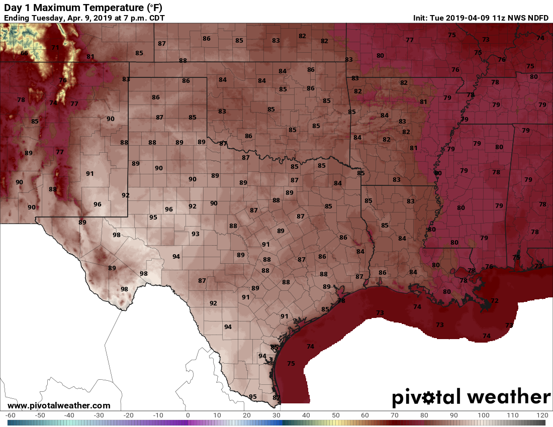
Get ready for Houston’s coldest weather since February

It’s a bit warmer this morning, with lows only falling into the lower 60s for most of Houston. But the air is also pleasantly dry, with relative humidity levels around 50 to 60 percent across most of the area when, during more muggy times, they would be closer to 100 percent. A reinforcing cool front will keep things on the dry side for Houston.

Tuesday

A cool front will move through the region today, increasing wind speeds this afternoon into the teens, with gusts up to around 20 mph. With the air so dry, there is virtually no chance of rain. Highs should reach the low- to mid-70s under mostly sunny skies.

The image of cloud top heights shows a low pressure system over the Midwest pushing a front through Texas this morning. (NOAA)

With the front’s arrival and influx of drier air, temperatures will fall pretty quickly after sunset, and inland areas should see lows in the 40s, while central and southern parts of the metro area are around 50 degrees or a bit warmer. While Los Angeles swelters under the heat of the Astros bats (and 100 degree temperatures this evening), Houston will be enjoying fine, fine weather.

Wednesday

A splendid day. Highs in the mid-70s. Sunny. Low winds. Another cool night.

See full post

Houston to experience amazing fall weather for awhile

Two of my very favorite words in Houston weather are “reinforcing front.” Often, during fall, we will see a cold front move into the region, push into the Gulf of Mexico, and then return onshore a couple of days later as a warm front. But when additional shots of cooler and drier air reinforce the initial front, we can get a run of cool, mostly dry weather for a week or longer. And that’s just what we have ahead of us now.

Monday

It’s a chilly morning up north, with lows in the mid-40s for inland areas near Conroe and The Woodlands, and about 10 degrees warmer in the city of Houston and closer to the coast. With dry air and sunny skies, highs today should warm to about 80 degrees. But wait, there’s more! A reinforcing shot of cooler, drier air should move into Houston tonight.

GFS model 10-day forecast for Houston’s Hobby Airport. (Weather Bell)

Tuesday and Wednesday

With the additional, cooler air we should see some splendid fall weather both days, with highs probably around 70 degrees, give or take, beneath sunny skies. Overnight lows will range from the 40s inland to upper 50s closer to the coast. If you’ve been waiting for truly fall like weather, it has arrived.

See full post

Front moves through Sunday morning, with rains then winds

Good Sunday morning. As of 7:15am CT a cold front is moving through the northern parts of the Houston metro area, and should push through the city by 9am and off the coast by noon.

Residents can expect some rain showers and a few strong thunderstorms with the front’s passage, but the main line is storms is moving fairly rapidly to the south-southeast, so the strongest storms won’t last too long. Light rain is possible for an hour or two after the front’s passage later this morning before we dry out this afternoon.

High resolution modeling indicates storms should be moving away from Houston by noon Sunday. (Weather Bell)

After the storms move through northerly winds will persist through the afternoon hours as skies clear out. We can expect gusts in the 20s through the early evening hours as high temperatures perhaps hang around the upper 70s. Temperatures will cool fairly quickly this evening.

Most of the rest of the week looks clear, cool, and spectacular. We’ll have our full forecast on Monday morning.

There is more autumn to come, Houston

Good morning. Thanks to Eric for covering me the last few Fridays as I took some time to step away from weather forecasts and explore Utah, which is an absolutely incredible place. And there was snow, for real! Anyway, it’s good to be back in Houston, and it would be better if the Astros were to win tonight. Let’s do some weather, as it is an active, changeable period the next several days.

Today

An area of heavy rainfall formed overnight southeast of Houston dumping nearly 7″ of rain (including 4.5″ in an hour) near Friendswood along Clear Creek.

Localized but extremely heavy rainfall has occurred this morning southeast of Houston. (Harris County Flood Control)

The heaviest rain has shifted north, but Clear Creek may still rise a bit close to bankfull in spots but not out of banks. Street flooding is likely to continue a bit longer this morning in this area.

Radar as of 6:20 AM shows the rain weakening a bit and lifting further north. (GRLevel3)


So what does the rest of today bring? We’ll probably see continued periods of rain and thunderstorms east of Houston south to near Galveston. Rain will come in spurts, but it could be heavy at times. I think the heaviest will be east of where the serious rain was earlier this morning, and the rain should be intermittent enough in places like Friendswood, Dickinson, and League City to not cause any further serious problems. That said, there may be some pockets of street flooding issues in parts of Chambers or Liberty Counties today, but they’ll probably be isolated.  Elsewhere, keep an umbrella at the ready. Expect isolated to scattered showers and storms in the area, especially through early afternoon.

Temperatures will be held back a bit with clouds, but since we’re starting much warmer than yesterday, we should crack the lower 80s this afternoon (a few places west of the city may do middle 80s). We may see a few showers around this evening or overnight, but far less coverage and intensity than this morning. Most of us will stay dry tonight.

See full post