Memorial Day weekend has come and gone, Houston’s basketball season has unfortunately ended, and the first named storm has already graced the tropics—I guess we must acknowledge that summer has really and truly come to Houston. This means two things for the upper Texas coast: high pressure, and when there’s not high pressure it means the region is open to tropical moisture. To that end, with the onset of hurricane season, we’ll have some additional content this week. Later today, in fact, I’ll answer some commonly asked questions about Houston and hurricanes. Later this week Matt will talk about how Hurricane Harvey changed the way local meteorologists were challenged and changed by the storm.
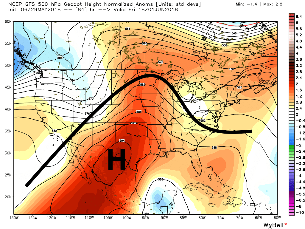
Texas is going to sit under a big, fat ridge of high pressure this week. (Weather Bell)
Tuesday
For now, high pressure ridging will remain dominant. There really is not a whole lot to say as we settle into a familiar pattern of warm, sunny days, with high temperatures in the low- to mid-90s, and warm nights in the mid- to upper-70s.
Yesterday’s thunderstorm activity probably came as a bit of a surprise to many of us, not so much because they happened but because of how potent they were. We saw a few reports of hail and wind damage around the region. And some incredible sky pictures.
Our Friday forecast suggested the most activity would be east of US-59 on Saturday, and it was, but I’d be lying if I told you I was expecting the potency that it came with. So why did it happen?
A confluence of factors led to a busy Saturday evening. Storms early in the day in western Louisiana and eastern Texas likely produced some boundaries in the atmosphere, and with winds directing weather in the less common northeast to southwest direction, they ended up moving our way. We probably saw cold air aloft, necessary to help regenerate storms as they moved across southeast Texas. We had sea breeze interaction with some of those boundaries also. There was decent jet stream and upper level support in the northeast flow that helped add extra support. Then, it also hit 94° at IAH, so you had plenty of instability. All these factors came together just right, and we ended up exceeding most people’s expectations, including my own.
So that begs the question: Will we do it again today?
Not long after our morning update on Friday, the National Hurricane went full steam ahead and declared the disturbance near the Yucatan Peninsula to be (Sub)tropical Storm Alberto (more on that in a moment). For us in Houston, this is of *no* concern. We remain with a hot and mostly dry forecast. But if you have friends and family east of here or know folks visiting there for the holiday weekend, we wanted to provide a quick update.
Now
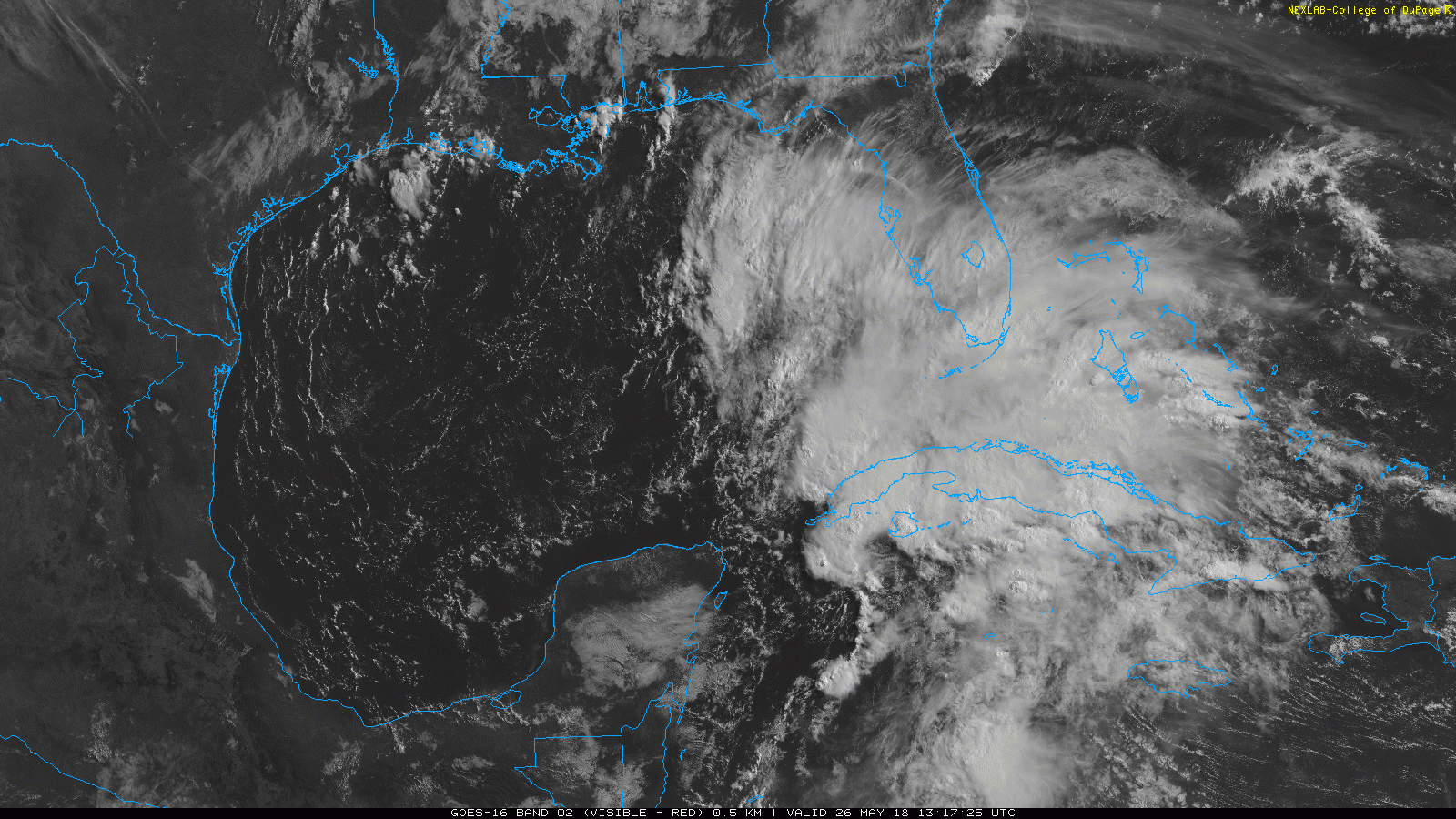
Alberto has maximum sustained winds of 40 mph, making it a lower-end tropical storm. Looking at a satellite loop, you can see Alberto is far from the most aesthetically pleasing tropical system we’ve ever seen.
Subtropical Storm Alberto late Saturday morning has a center in there somewhere, well displaced from the majority of the thunderstorm activity. (College of DuPage)
The center of Alberto is sort of broad in nature and located just off the western tip of Cuba. It may hopscotch its way along over the next 12-24 hours, reforming at times in different places in the southeast Gulf.
Forecast track & intensity
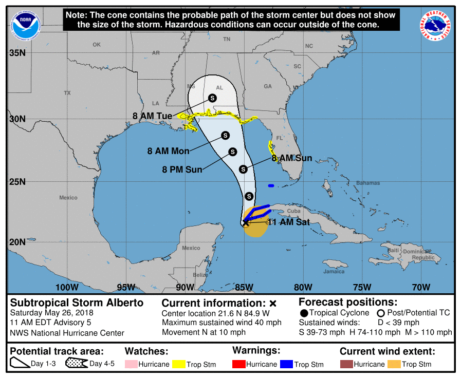
Over the next 24-36 hours, the environment over Alberto is expected to become more hospitable for a tropical storm. Thus, Alberto should strengthen a bit on its trek north. The current forecast from the National Hurricane Center takes Alberto north to between about Gulfport, MS and Panama City Beach, FL, with a possible landfall by Monday night or early Tuesday.
The National Hurricane Center forecast has Alberto approaching the central or eastern Gulf Coast by Monday night as a moderate to strong tropical storm. (NOAA/NHC)
While the NHC track is fine, some forecast modeling shows Alberto taking a more erratic path as it approaches the eastern Gulf, possibly shifting a couple hundred miles east or west. Thus, tropical storm watches cover a pretty broad chunk of the coast, between far eastern Louisiana and the New Orleans area to just south of Tallahassee on the Florida Panhandle. The Tampa area is also under a watch. Tropical storm watches mean tropical storm conditions are possible within the next 48 hours.
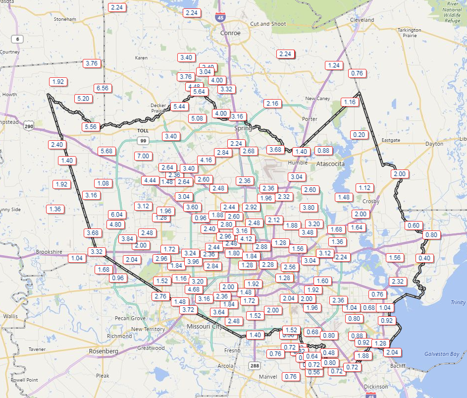
If the weather forecast going into next week holds, we may look back on this week as being one of the more important weeks of summer, because we needed some rain and most of us have received some.
Rain totals over the last 7 days as reported by various Harris County Flood Control gauges. (Harris County Flood Control)
Yes, some areas have been mostly avoided, which is unfortunate, but regionally, at least we were able to ease the potential descent into drought. We have a very repetitive forecast over the next week or so.
Today & Saturday
Both days will carry at least a chance of showers. Radar has a couple offshore showers this morning, but nothing too significant. I expect we’ll see showers kick up later this morning (after 9-10 AM) near the coast, then spread inland this afternoon. Coverage will be similar to a little less than what we saw yesterday. Some of you may pick up a quick quarter to half inch of rain with thunder. Others will again listen longingly to distant rumbles of thunder.
Saturday should see slightly less coverage of storms, especially west of US-59. The better chances for showers tomorrow will be east of US-59, especially as you get closer to Beaumont/Port Arthur and Lake Charles.
Temperatures today and tomorrow will top off around 90 or in the lower 90s. And they may also be the coolest days of the next 7-10.