In brief: A tropical disturbance has developed in the southern Gulf, and it is expected to move into Mexico early next week. Houston can expect to see elevated rain chances on Sunday due to moisture from this system.
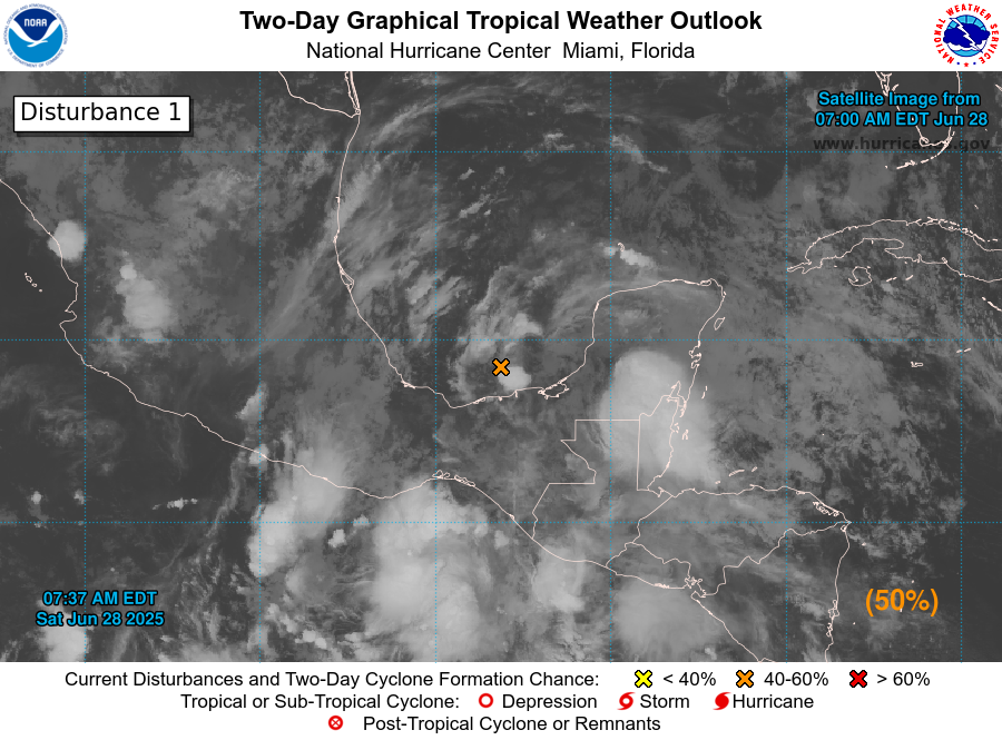
I hope everyone is having a great start to the weekend. It is sunny for most of us, and should remain so for much of today as high temperatures climb to around 90 degrees. For late June, this is mild weather. However, if we look a little bit further afield this morning we can see an area of low pressure in the Bay of Campeche, in the southern end of the Gulf.
The system should slowly move to the west, toward the coast of Mexico, and push inland by Monday. There is a healthy chance (50 percent, says the National Hurricane Center) that this could become a tropical depression or storm during the next 48 hours, before moving inland. The waters there are plenty warm to support development.
The National Hurricane Center gives this disturbance a 50 percent chance of developing.
We are interrupting your Saturday to emphasize that this system is of no threat to Houston in terms of high seas or winds. That goes pretty much for the entire state of Texas. However, moisture associated with the tropical low pressure system should help to increase rain chances on Sunday, and possibly into Monday.
This, as well, is not of too much concern. Overall I would expect accumulations for areas south of I-10 to average 0.5 inch or less on Sunday, with lower totals further inland. However, at this time of year, especially with tropical rainfall, we can see rain totals pile up quickly. So it would not surprise me to see a few isolated areas pick up a couple of inches of rain on Sunday, which would briefly cause some ponding on streets and in parking lots. Again, for the vast majority of the region these should just be your garden variety showers and thunderstorms.
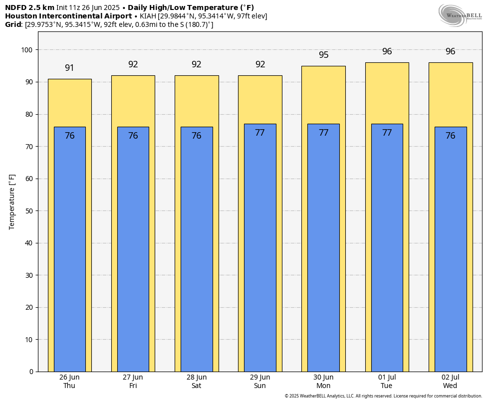
Lesser rain chances linger into Monday, and then most of next week looks hotter, with highs likely reaching at least the mid-90s.
In brief: Another round of localized heavy rain, street flooding, and lightning will be possible this afternoon somewhere near or just northwest of Highway 59/I-69 in Houston. Slightly less coverage for Saturday, then more numerous showers and storms come at us Sunday and Monday before we dry out and heat up.
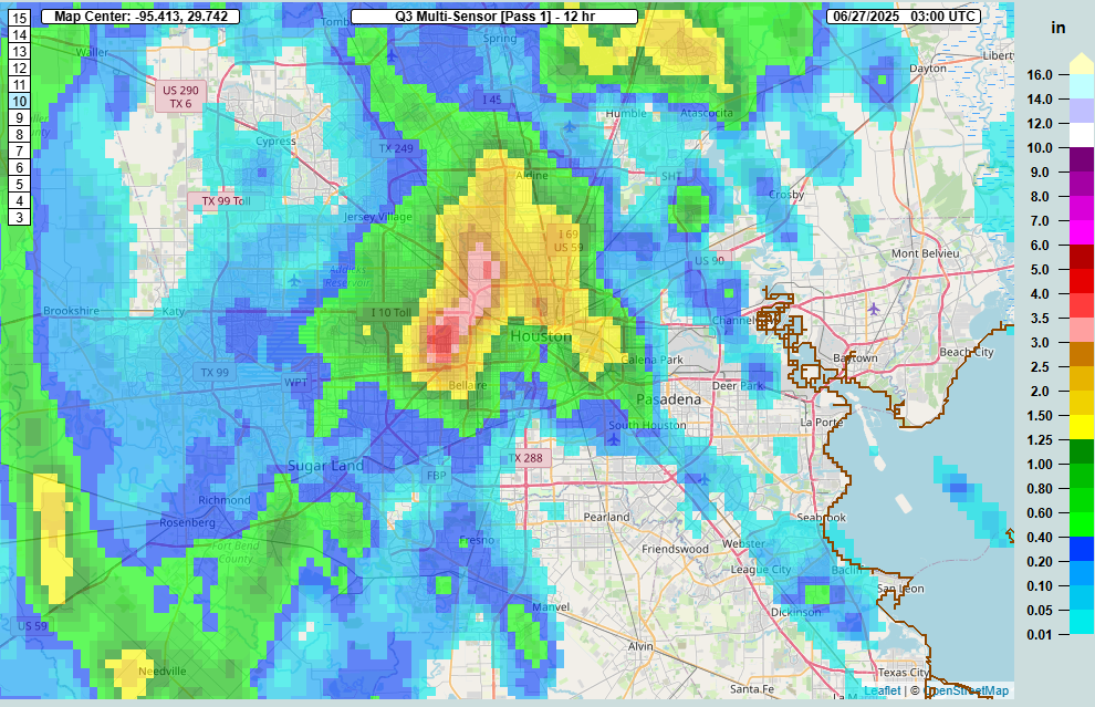
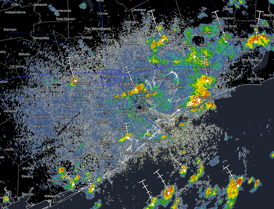
If you live inside the Beltway on the north and west side of Houston, you probably got walloped yesterday. Over 4 inches of rain was recorded at Ella and White Oak Bayou.
Rainfall estimates yesterday afternoon ranged from near or over 4 inches just west of the Galleria through Garden Oaks. (NOAA MRMS)
Rain totals north of 3 inches fell in a pretty broad area between The Villages and Garden Oaks. Many other locations saw 1 to 3 inches of rain. Outside the Beltway, it went quiet until you got up to about Kingwood (always, Kingwood) and down into Fort Bend County. Yesterday was just one of those days where boundary collisions ruled the day. A few storms popped up, steering winds were weak, and basically atmospheric bumper cars ensued until we exhausted the instability in the area.
Today
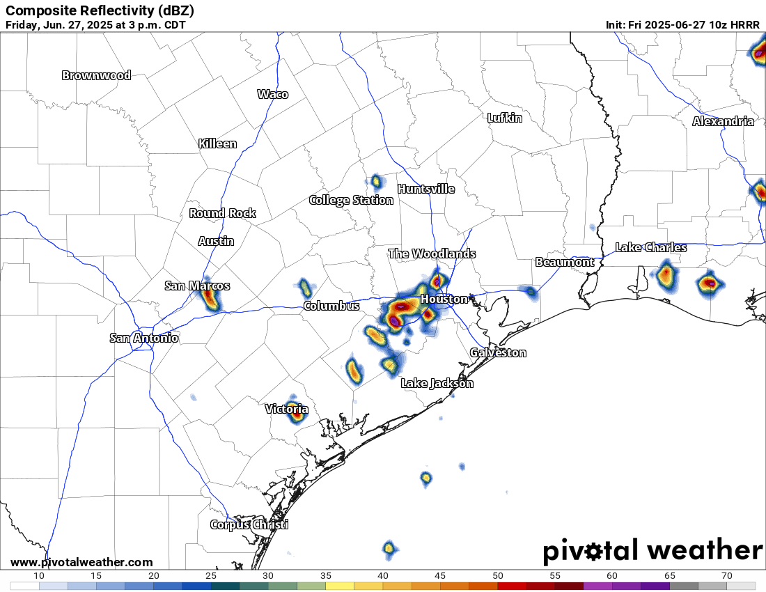
We don’t expect a carbon copy today, however I would not be shocked to see a generally similar setup play out across the area. We’re already seeing some downpours in Liberty and Chambers Counties this morning. As the morning goes on and the sea breeze starts entering the mix, migrating inland with peak instability, we’ll likely see storms fire up near Highway 59/I-69.
Forecast radar from HRRR model for 3PM today showing isolated heavy downpours. Don’t focus on the specific location but rather the generalized picture. (Pivotal Weather)
A few places could again see multi-inch per hour rain rates that could cause street flooding. We’re holding off on a Stage 1 flood alert today, but I will admit it’s a close call. Just use caution in any storms today, as you should in summer.
Weekend
I think things will ease up a bit on Saturday. There will be showers and isolated thunderstorms around. There may be locally heavy downpours for a short time in any given spot. But overall the intensity and coverage of storms may be lower tomorrow than it has been to close the week out.
Unfortunately, the same does not hold true for Sunday, which should see more numerous, if not widespread showers and thunderstorms across the region. Storms could begin firing up as early as mid-morning and continue through the day, migrating generally north and west as the day progresses. Have an umbrella handy both days, but have a good indoor backup plan available on Sunday.
Temperatures should top out in the lower to mid-90s on Saturday and low-90s or even upper-80s on Sunday.
Monday
Monday looks like another active day with showers and storms popping with daytime heating. Look for low-90s and scattered PM storms.
Rest of next week
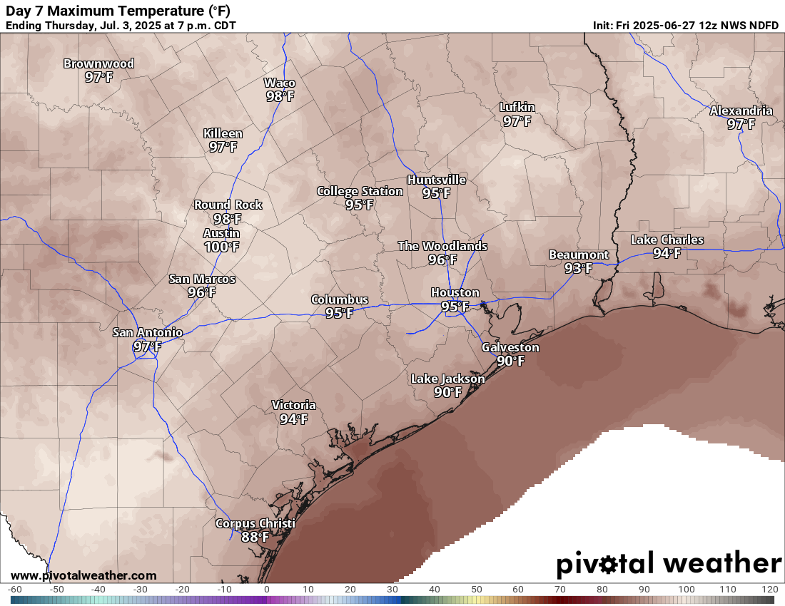
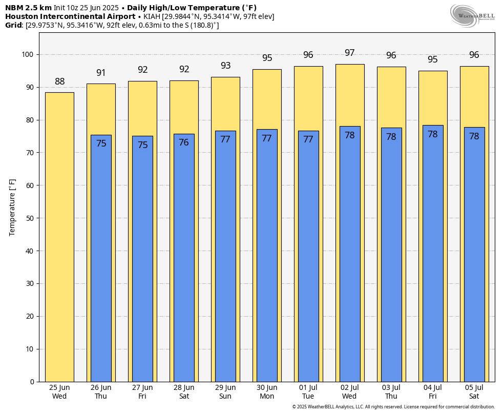
Tuesday begins a trend of diminishing rain chances. Expect more of isolated coverage of storms on Tuesday, a handful on Wednesday, and perhaps none at all by the end of the week. In response, temperatures are going to begin to pick up. We’ll have mid-90s Tuesday and Wednesday, followed by a chance at upper-90s to close the week.
By next Thursday, some areas do have a chance at upper 90s. (Pivotal Weather)
Recent rains and saturated soils may act to keep daytime highs from getting much past 97 or 98 degrees or so officially, but there may be a few parts of the area that threaten upper 90s to near 100 by next weekend. Stay tuned.
Tropics
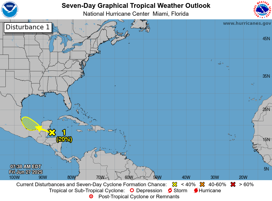
A discerning eye will notice a new tropical area to watch on the National Hurricane Center site down in the Bay of Campeche. This has a very, very slight opportunity to develop over the next couple days.
A possible disturbance in the Bay of Campeche will not be of concern for Texas. (NOAA NHC)
The good news is that it will almost certainly scoot right into Mexico by Monday. This limits any significant development risk, and this is not a concern for the Texas coast. The next tropical area of interest may be something in the northeastern Gulf or off the Florida coast by next weekend. That too is expected to stay away from Texas and is mainly worth watching for Florida or the Southeast coast.
In brief: In today’s post we discuss the ongoing rain chances for today and through the weekend, as well as the arrival of a new round of Saharan dust. We also are happy to share the news that we think we have finally tackled the notification issue on the Apple version of our app.
Yes, we think app notifications are finally fixed
As many users of our Space City Weather app installed on Apple devices know all too well, notifications on that platform have been broken. After installing, they’ll work for a couple of weeks and then stop. This has been annoying for you and a giant pain in the butt for us. We tried several things to fix it, only to have the problem return.
Now, we think—all fingers and toes crossed!—that we have solved it. Hussain Abbasi, our developer, initially wrote the app in a Microsoft coding tool that lost support this year. Meanwhile, Apple changed the way app notifications are handled, but Microsoft didn’t update its older tool to account for that. Once Hussain realized this, he began the painful process of recreating the app in the new version of Microsoft’s coding tool that does use Apple’s latest notification system. What at first appeared to be a minor bug fix turned out to be, as they say, a heavy lift.
Fixed, finally. (Space City Weather app)
We released the app a few weeks ago, quietly, to see if it indeed fixed the problem. And it appears to have done that. There are still a few bugs in the new version, which is to be expected since it’s essentially a rewrite of the app. We hope to have some bug-fix updates coming in the next few days and weeks. In the interim, you may notice that weather data loads a little slowly at first. And some iPhone and Mac users are reporting the app crashes upon launch, but that appears to be rare and the cause has been identified.
If you have updates set to auto-install on your device, you already have the new version. If you haven’t updated and want notifications back, feel free to download it. (it might help to uninstall the old version before installing the new one.)
Note that this only applies to users of Apple devices. The Android version is, for now, unchanged, but our upcoming releases will address some issues there, too, including the occasional crash on, weirdly, Pixel 9 phones only. Go figure.
Thanks for using our app! We’re working to make it better for you.
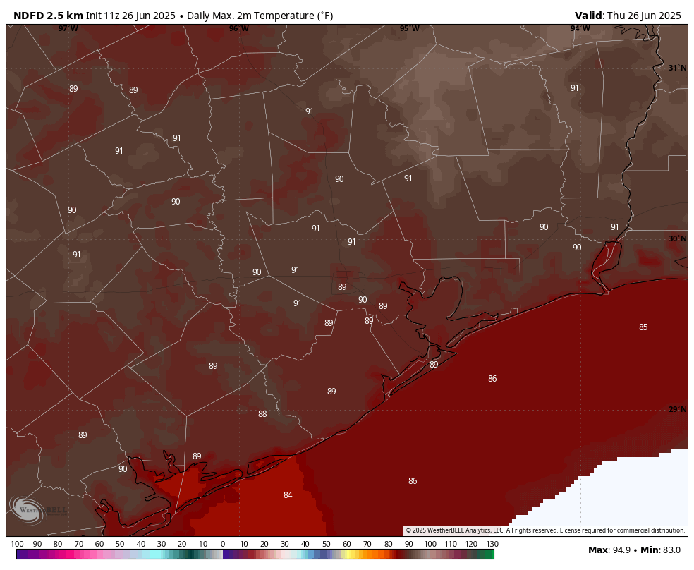
High temperature forecast for Thursday. This is pretty nice for late June. (Weather Bell)
Thursday
The atmospheric setup supports another day of variable shower activity today, with some areas likely to pick up 1 inch of rainfall and other locations seeing only dark clouds and distant lightning. Overall rain chances are about 50 percent, with the most likely time for showers from late this morning through the early evening hours. The proximity of rain will help keep high temperatures in the vicinity of 90 degrees for most locations. And yes, while this is fairly warm, I’d remind you that it is but a taste of what is coming in terms of summer time heat for Houston. (i.e. see the forecast for next week). Rain chances will slacken for the overnight hours, with low temperatures falling into the mid- to upper-70s.
Friday and Saturday
These days will be similar, with partly to mostly sunny skies and high temperatures of around 90 degrees, or just above. They will also be subject to hit-or-miss showers, but I expect coverage to be less, perhaps 30 percent daily. Winds will generally be light, from the south, at 5 to 10 mph. Beginning Saturday or Saturday night we might being to see some hazy skies due to an increase in Saharan dust.
Sunday and Monday
Sunday, and possibly Monday, will bring another shot of decent rain, perhaps 50 percent daily. Accumulations don’t look overly impressive, but some locations may quickly pick up half an inch of rain. Highs on Sunday may top out around 90 degrees, but we should climb into the lower 90s by Monday.
More serious heat is coming later next week. (Weather Bell)
Next week
As high pressure builds nearby we are going to see mostly sunny weather. Temperatures will start out in the mid 90s (coastal areas will be a bit cooler) with highs likely approaching the upper 90s toward the end of next week. Skies will be mostly sunny, but the lingering presence of Saharan dust should help moderate dewpoints slightly. So very hot, and quite humid—but not sizzling humid maybe. We’ll still have a daily chance of shower activity along the sea breeze, primarily during the afternoon hours, but these chances are likely on the order of 20 percent. Basically, it’s going to feel very summer-like out there.
In brief: We continue to be in an environment where showers and thunderstorms are possible, and may be numerous during the daytime. This pattern will hold through today and possibly Thursday before slightly drier weather. Later, some time next week, temperatures appear likely to soar into the mid- or upper-90s.
Wednesday
Showers and thunderstorms on Tuesday were definitely hit or miss: Some areas near Tomball and Sugar Land received in excess of 1 inch, while most of the rest of the region picked up significantly less. Then, last night, more than 1 inch fell in locations near League City. This pattern is likely to continue today, with hit or miss showers and thunderstorms across the region. Storms should be more common near the coast this morning before spreading inland later today.
As of shortly before 7 am showers are beginning to develop over coastal areas. (RadarScope)
Overall rain chances are probably on the order of 60 percent with everything from gully washers to light rain to simply ominous skies in your neighborhood. Flooding shouldn’t be too much of an issue, but we cannot rule out some ponding on streets. Highs today will reach the upper 80s for most locations, but areas far inland will see a little more sunshine, and may push into the lower 90s. Winds will generally be light. Lows tonight will drop into the 70s, with decreasing rain chances.
Thursday
Expect a similar day to Wednesday, albeit with perhaps slightly less coverage of showers and thunderstorms. Nevertheless the potential for moderate to strong, if briefly lived, storms will be there. Temperatures and humidity will be similar to Wednesday.
Friday and Saturday
A slightly drier air mass should drop rain chances back to around one-in-three for each of these days, with decreasing intensity. As a result skies should be partly to mostly sunny, with highs in the lower 90s. For the most part, I think outdoor activities will be fine.
Sunday and Monday
These days should bring slightly better rain chances, perhaps 30 to 50 percent, but overall accumulations look modest. Expect highs in the lower 90s.
Downright hot weather is likely for much of next week. (Weather Bell)
The rest of next week
A modest ridge of high pressure may build over much of Texas later next week, and by Wednesday or so we should be solidly into the mid-90s, and possibly hotter toward the end of next week. So expect July to feel very July like. Whether this ridge sticks around or breaks down to allow some rain chances to return, well, we’ll just have to see. It’s not August—yet.