Some severe thunderstorms rumbled through Houston during the overnight hours, bringing some scattered reports of hail and damaging winds (a private airplane hangar was damaged at Hobby Airport). While the light show was impressive, rain totals were modest, with most of the region getting 0.25 to 1.0 inch of rainfall. In the wake of Tuesday night’s front we’re left with gusty winds, reaching the low 30mph in some locations this morning.
Wednesday
Skies today will be clearing out, leaving us with lots of sunshine later today. Temperatures will hold steady at about 70 degrees, however, and winds will remain brisk out of the north. Skies tonight will be mostly clear, with temperatures generally in the 50s—cooler to the north of the city and warmer to the south.
Thursday
A nice day, with partly to mostly sunny skies, and highs in the 70s. As winds shift around to come out of the southeast, moisture levels will rise some, and we can’t entirely rule out of a few brief, scattered showers later in the day. For the most part, however, this should be a pretty nice day.

Friday and Saturday
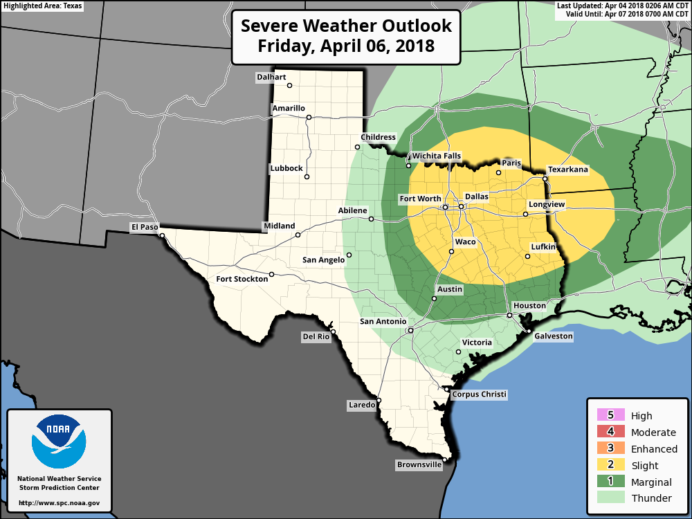
Friday will start out mostly cloudy, and I expect high temperatures to rise to about 80 degrees. Later Friday another cold front will approach the area from the north, and this could lead to some scattered afternoon showers. Rain chances will tick up during the overnight hours, but at this point the most favorable dynamics for any severe weather appear to be north of the metro area, including places such as Lufkin and Dallas. Even so, I’d expect perhaps a few tenths of an inch of rain from Friday night through early Saturday morning across much of the Houston area.
The front itself now appears likely to move offshore, which will make for better weather conditions in the city this weekend. Most forecast models now indicate that rain chances should fall off by mid-morning Saturday, if not before, with hopefully some partially clearing skies later in the day. Highs will probably be around 70 degrees, with a cool night in the 50s.
Sunday
The second half of the weekend should be great, with mostly sunny skies and highs in the mid-70s.
Early next week
Another moderate cool front should arrive sometime on Monday, but this time there probably won’t be much moisture, so rainfall isn’t much of a concern. This front should provide enough of a push of dry air to keep conditions pleasant—with highs in the upper 70s to 80 degrees, and pleasantly cool nights.
I guess this is our last spell of nice weather until October, so enjoy it!
3/4″ of rain at my house, slept through everything.
Eric, a side question, we are relatively new transplants to Houston from north east. I am not used to seeing these heavy thunderstorms. Do we need to secure our homes from Lightning bolts? Last night was pretty overwhelming.
Hey Rich. This is pretty normal Houston spring weather.
Actually, you need to put your home on pontoons for the annual 100-year flood.
We had 1.25″ of rain here in Lakemont, just south of Westpark Tollway at S. Mason Rd. Most of the lightning appeared to be to our north. Thanks for the updates and reasonably accurate predictions. I find them an intelligent addition to my other sources of weather information.