My family and I were driving through Houston on Tuesday evening, after a long day in the car returning from a family reunion, when the heavens opened up. I certainly did not expect to hit that kind of storm, with winds in excess of 40 mph at some locations, and relatively brief heavy rainfall. But it goes to show you what summertime Houston can do in absence of dominant high pressure and with a sea breeze during the afternoon and evening hours. Today could see similar activity, although I don’t think it will be as widespread.
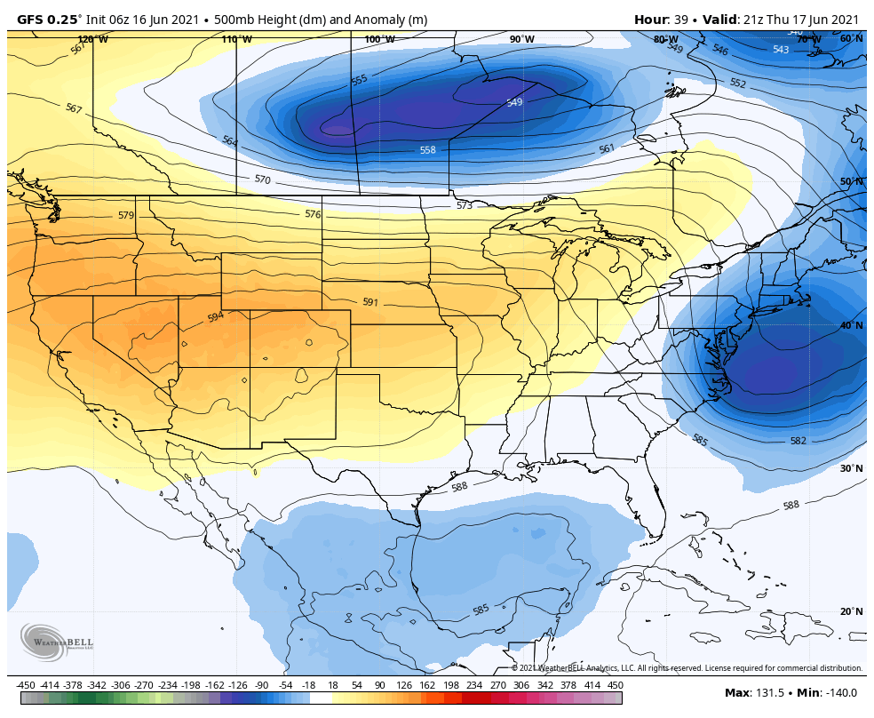
The other two big stories are the heat and the potential for a tropical depression in the Gulf of Mexico. I’ll discuss the latter below. But in regard to the heat, Matt shared this sobering statistic with me. Before the storms fired up on Tuesday, Bush Intercontinental Airport hit 98 degrees for the fourth straight day. Since 1888 that has happened only three other times this early in summer: in 1902, 1998, and 2011. All three of those years ended up in the top-15 warmest summers, and 2011 was the warmest summer on record.
Wednesday
Houston remains on the periphery of an intense ridge of high pressure situated over the Western United States. Effectively, this means that we’ll see hot weather, as well as a chance of showers and thunderstorms this afternoon and evening driven by the sea breeze. Coverage should be less than on Tuesday afternoon. Otherwise, look for highs again in the upper 90s, with sunny skies. Lows tonight will remain around 80 degrees, or just below.
Thursday
Another day like Wednesday, albeit with temperatures perhaps a degree or two cooler, and rain chances a little bit lower as well. For most of us, this will simply be a hot and sunny day.
Friday, Saturday, and Sunday
Beginning Friday our weather will be largely dependent on the development of the tropical system in the southern Gulf of Mexico, and its eventual track northward. I’ll discuss the system in the section below, but for now our forecast—which is very much subject to change—is as follows.
Friday will likely see mostly sunny conditions, with highs in the mid-90s, and increasing rain chances along the coast. These showers may spread inland overnight. However, as Matt has discussed, this likely will be a lopsided tropical system, likely with the vast majority of its effects on its eastern side. So if the “center” makes landfall even slightly east of Houston, we’ll fall on the dry side of the storm. I think this will happen. So while there is definitely a chance of heavy rainfall in the Houston region on Saturday, it now seems more probable that we’ll see little to no precipitation.
Regardless of what happens on Saturday, by Sunday the system should be moving away from the region, leaving us with mostly sunny skies, a lingering chance of showers and thunderstorms, and highs in the mid-90s.
Gulf of Mexico disturbance
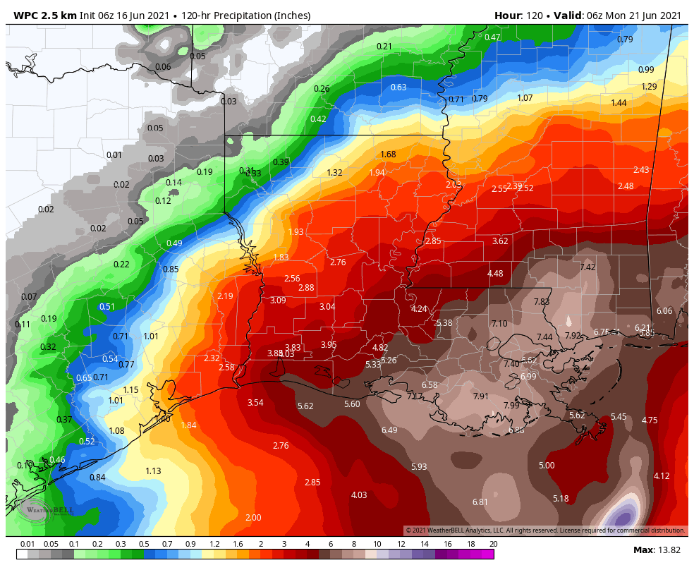
The disorganized system of showers and thunderstorms is still expected to coalesce into a tropical depression or storm this week, and the National Hurricane Center gives it 90 percent chance of doing so. As this system presently lacks a center, there is the usual uncertainty in track and intensity forecasts. With that said, the overall pattern now favors a more northward track, and this likely would bring the low pressure system toward southern Louisiana, rather than Texas. This is why I’m leaning against heavy rainfall in Houston this weekend, but not ready to make a definitive call. I definitely have more concerns about Louisiana, however, especially the New Orleans area which may see 10 to 15 inches of rainfall.
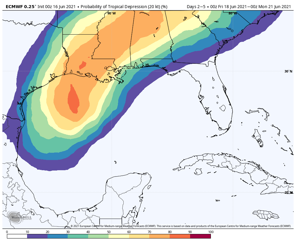
In terms of intensity, the combination of wind shear and ingestion of dry air will likely limit this system’s potential to that of a low-end tropical storm. But again, it’s difficult to say anything definitive at this time.
Eric, if you had to guess (and I AM asking you to, pretty please) when would the storm start dumping on the Louisiana coast?
Yes please I would like to know as well! We will be in NOLA from Friday evening until Sunday 🥲.
2″ here last night – the bulk of it in about 40 minutes.
2″ here last night, the bulk of it in 40 minutes.
Certainly 2011 was as hot as 2021 has been, but by this time in 2011 we were already deep in what would turn out to be a catastrophic drought–which makes all the rain we’ve gotten this year a real relief when making comparisons.
Space City Team – love the posts as always. Any tide predictions for the gulf coast? Galveston, Surfside, Bolivar etc? Will we see any swell or surge?
The outbreak of thunderstorms yesterday was actually a happy surprise, starting with the darkening skies. Any reduction in sunshine means less heat.
I’d love for this moisture blob to move 50 miles to the projected west to keep us covered with more cloud cover.
With all of this heat, why couldn’t this be transferred to last February during the freeze? Or, take some of the February cold and dump it here today? Wishful thinking, I know.
Of course this is conceptually possible. It is called geothermal heating and AC.
Even solar with batteries works. It is very cool in my house right now and since 2AM I am drawing nothing from the grid at all, just running off batteries then solar. At around 4 the batteries kick in and run the house until ten. Between 10 and 2 AM will draw a tiny amount of power from the grid
We had hailstones the size of nickels in n. heights yesterday bouncing all over amidst the crazy monsonic rain.
Yes, please update us on Louisiana. I’ll be in Lake Charles for a business trip this weekend. Not looking forward to the weather.
Great reporting as always. Approximately 3 inches fell in the area north of Bay Area Blvd and South of El Dorado between I-45 and Hey 3 yesterday per my rain gauge located in Pipers Meadow subdivision between 7 pm And 8 pm. (Time is approximate) made for some scary driving.
Barely any rain in First Colony, but man, some excellent thunder backdrop for 2.5 hours. Great during Astros game. But not so great for traumatized dog
Bill — Try “thunderburgers” next time. Whenever there’s thunder, the doggie gets a little treat of whatever he or she likes. That should turn fear into anticipation in just a little while. It usually works, anyway…
Eric, you mentioned the storm in the southern Gulf and “it’s eventual track northward.” Why northward? Why not westward, eastward, or to the south? I don’t understand the drivers here, but it seems to me that storms in this area nearly always track northward, although I think I remember a few that have moved westward into Mexico.
Eric, you mentioned that 2011 was our hottest summer. One difference that I can recall is that in 2011 we had been warned since like around January 2011 that we were going to have a horrible drought in the south – one of the worse ever – and WE DID. This spring and early summer so far has been pretty wet, do you think that could have any bearing on possibly 2021 NOT being so hot even though these last few days have been bad? Any thoughts?
We are making the trek to 30A on Saturday.
Will I-10 be a big issue with flooding, wind?
Should we leave Friday to avoid LA and try to make it in to another state?
You have merged dry facts sets of technical writing with interesting and entertaining feature writing, creative writing, informative writing and journalism and made it my most interesting read of the day. I hope your Hs and Uni writing teachers know bec they will be quite proud !
Thank you for bringing us such concise reports! It’s great to be able to read the weather rather than try to make sense of the weather on the local news! I have been a fan of spacecityweather since 2017. I have also referred many people to the website!