Why are thunderstorms so common during spring months?

As most Southerners know, the arrival of spring also means the arrival of severe weather season. On Wednesday morning, many Houstonians heard the first rumblings of serious thunder for 2018, and if history tells us anything, this is just the beginning of a potential spring full of thunderstorms, flooding, lightning and tornadoes. What is it about the springtime that initiates this activity?

Hot, Hot Heat

Thunderstorm formation depends on atmospheric stability. We’ll forego talk about lapse rates and latent heat for now, and describe stability in simple terms. During the wintertime, our atmosphere is generally very stable. This means that conditions in the air prohibit any vertical motion. For thunderstorms to develop, they need warm air to rise from the surface, then to cool and condense into a tall, vertical column of clouds. In a stable atmosphere, this is nearly impossible.

As winter turns to spring, two things occur that make the atmosphere much more unstable. First, the air around us, especially if that air comes in from the Gulf, becomes much warmer and much more humid. Yesterday, February 20th, Bush Intercontinental Airport recorded a high of 80°F, with relative humidity values staying above 70%. This warm, moist air mass created a perfect environment of instability around us.

This diagram shows how air, heated at the surface, rises in the atmosphere until it condenses into a cloud. (Ahrens)

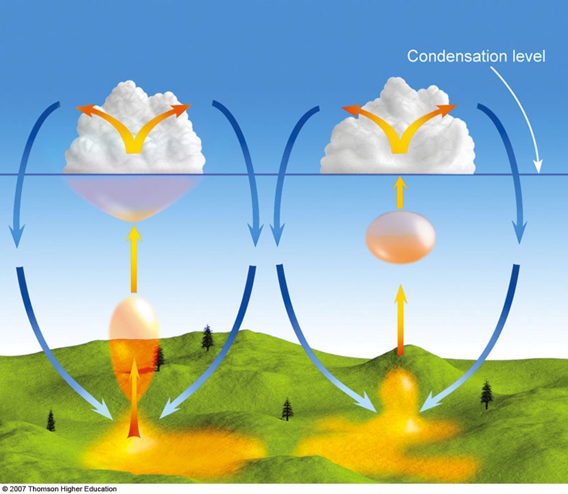
Second, as days become longer and the sun rises higher in the sky, the sun heats the ground, which, in turn, heats the air directly above the ground. This warm air will eventually rise in an unstable atmosphere, pushing cold air out of the way, as the diagram above shows. As it goes up, the air begins to cool, and as it cools, the water vapor in the air will condense–into clouds! If the atmosphere remains unstable, and these pockets of warm, condensing air rise rapidly, we have the recipe for a thunderstorm.

See full post

La Niña and Houston’s Winter Weather Outlook

Now that “Fall Day” has ushered in autumn, and we hopefully won’t see 90 degrees again until 2018, the time has come to look ahead to winter. Specifically, we want to look at the impact a potential La Niña could have on Texas. The Climate Prediction Center recently issued a La Niña watch, giving the Northern Hemisphere a 55 to 65 percent chance of experiencing cooler than average waters in the eastern Pacific Ocean. Let’s take a step back however, and discuss what La Niña is, and how it could influence our weather in the coming months.

La Niña (and El Niño)

El Niño and La Niña are the warming and cooling phases of water in the eastern Pacific Ocean, off the coast of equatorial South America. El Niño occurs when the water is warmer than usual, La Niña when the water is cooler than usual. The changes aren’t radical—just 0.5-4°C either way. However, that type of change, over such a wide swath of ocean, has a massive impact on the global climate. It’s a classic example of the butterfly effect. A seemingly small change in another part of the world results in big impacts everywhere else.

As of the last update, surface ocean temperatures off the coast of Peru are between 0.5°C and 3°C below normal. The longer this pattern persists, the more likely La Niña will impact the globe.

Sea surface temperature anomalies for October 2017 (Climate Prediction Center)

See full post

When the rains stop, here are some first steps to take for your property

Tuesday, 8:30am CT—Understandably, it is hard to think about what must be done after a natural disaster. We know the stress of the moment is nearly too much to bear—especially for those of you who are dealing with immediate flooding issues. Water in your home. A flooded business. A lost vehicle. All of our thoughts and prayers are with you.

We are not experts in disaster recovery, we’re just forecasters. But we can provide some basic information about what to do when the rains are finally over, and we all will have to face the reality of damaged or lost property. While it may be difficult to fathom a return to normalcy right now, we hope this information may prove useful in the coming days.

Home flooding

Though flood waters may begin receding from your neighborhood, do not go back into your home until authorities say it is safe (i.e. despite the temptation, do not drive around barriers). This may not happen until Thursday or Friday, as Harvey finally leaves the area. Roadways can appear safe, but flood waters could erode the ground from under the asphalt, creating sinkholes. Wait until roads are free of water and safe to drive before attempting to return. Avoid standing water as well—water could be electrically charged from power lines, or hide dangerous wildlife (think alligators, snakes, or floating beds of fire ants).

A raft of fire ants in Pearland, Texas. (Brant Kelly/Flickr)

Once you get into your home, the first thing you should do is turn off the electricity at the main breaker, even if power is out in your community. Turn off the gas valves that feed into each individual appliance (stove, water heater, etc.). Then, carefully check your home to make sure there is no structural damage. Flood waters can put tremendous strain on the structure of a home. Take plenty of pictures of anything that is damaged, and contact your insurer immediately. As you begin any cleanup efforts, keep receipts. It may take insurance adjusters days or even weeks to assess your damage, so keep meticulous records. Finally, remember that flood insurance is a separate policy from homeowner’s insurance.

See full post

When inland flooding comes, rainfall rate is the key

By now, we’ve all been inundated (pardon the pun) with model graphics such as the one Eric shared earlier this morning:

Rain accumulation forecast for now through Friday morning, Sept. 1. (NOAA)

As he mentioned, it is indeed a realistic portrayal of the rain our area could get over the next week. Twenty-plus inches of precipitation in such a short period of time is daunting, especially when you consider Houston averages around 50 inches a year.

We’ve had a number of questions about how the area’s bayous will manage the rain. Surely, they could handle four inches day, for five days, right? Unfortunately, for tropical systems like Hurricane Harvey, it isn’t the amount of rainfall that becomes a problem, as much as the rainfall rate. What is rainfall rate, and how will it and other factors influence how bad our flooding will be this week?

What is rainfall rate?

Rainfall rate describes how much rain falls over a period of time, and is measured in inches of rain per hour. A rainfall rate of 0.5″ per hour is considered heavy, while anything above 2.0″ per hour is intense. For context, Harris County experienced a maximum rate of 4.7″ per hour during the 2016 Tax Day Floods in a few isolated locations. It’s the difference between your sink faucet dripping for a week (a low rate), and your faucet breaking off for a half hour (a high rate). The same amount of water may come out of your pipes, but one will flood your kitchen much faster than the other.

Ditches and storm drains in Houston and Harris County can generally handle a rate of 1″ to 2″ per hour, for a few hours. Anything higher than that, over a longer period of time, leads to excessive runoff that can flood roads and fill the bayous faster than they can handle it.

See full post