Flashback Friday: Back to the 80s

On Thursday, we maxed out at 78° officially at Bush Airport and 80° at Hobby. If you thought yesterday was warm, wait until today.

TODAY

I’m not sure what the split is going to be on today’s weather, but I imagine about 50% of you will love it and 50% of you will loathe it. It’s going to feel like more like early to mid-fall than almost winter: High humidity and very warm temperatures. We should be able to officially slide past 80° this afternoon for the first time since November 16th. Hey, at least we aren’t Laredo, which should test 90° this afternoon! Aside from warmth, it will be dry with a mix of clouds and sun.
See full post

We’ll endure near-record heat and storms before a cold front Sunday

It’s another foggy morning and a dense fog advisory is in effect until 9 a.m.

TODAY-FRIDAY

Goodbye winter, hello early fall. Houston will see two days of near record heat with highs around 80 degrees, with sultry lows in the upper 60s. These overnight temperatures are nearly 25 degrees warmer than normal for mid-December. Skies will be partly to mostly sunny.

SATURDAY

Saturday will start out warm and muggy, with humidities near 100 percent. Heaven help you if you’re running a half marathon that morning because it’s going to be absolutely miserable for long-distance runs.

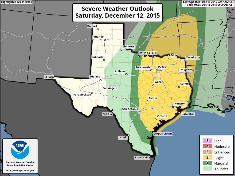
Rain chances will be relatively low during the day, but increase a bit during the afternoon before spiking after sunset as a storm system approaches and clashes with the Gulf of Mexico moisture. The entire region is under a “slight” chance of severe weather, according to NOAA’s Storm Prediction Center, with damaging winds the primary threat.

NOAA's Storm Prediction Center outlook for Saturday and Saturday night.
NOAA’s Storm Prediction Center outlook for Saturday and Saturday night.

See full post

Very warm through Friday, storms possible on Saturday, and then cooler

Houston remains under a dense fog advisory until 9 a.m. this morning.

TODAY-FRIDAY

The region will continue to see a warming trend, with highs in the mid-70s today, and possibly record high temperatures around 80 degrees on Thursday and Friday. Lows will climb from the upper 50s Thursday morning to nearly 70 degrees by Saturday morning. Skies will be mostly Sunny.

Mele Kalikimaka, everyone.

SATURDAY

Moisture that has piled up during the previous three days will rise upward due to an advancing front. This will bring about a decent chance of rain during the day, and an even better chance on Saturday evening and during the overnight hours. Due to the unstable nature of the atmosphere some severe thunderstorms will be possible, with possibly even some isolated tornadoes. Check the forecast before heading out to any evening or nighttime plans.

In terms of accumulations, I still think 1 to 2 inches is a good bet for rainfall.

See full post

Warming up for a soggy Saturday, then hopefully drier on Sunday

It’s another chilly morning across Houston, with temperatures in the 40s across the metro area, but we’re going to transition out of the cool pattern we’ve been in for the rest of the week.

TODAY-FRIDAY

We’re going to see gradually warming conditions over the rest of the work week, and we’ll also start to see some clouds. Please do not be alarmed by white, fluffy, cuddly looking things in the sky. Those are clumps of moisture that have condensed. They are not harmful.

High temperatures will rise from the low 70s today to the upper 70s by Friday, and low temperatures will increase from the 40s today, to the 50s on Wednesday and Thursday morning, and into the lower 60s by Friday and upper 60s by Saturday morning. As temperatures rise, humidity levels will too.

Because we’re so dry rain chances will remain very low.

See full post