Storms possible late today northwest of Houston

Good morning. Storms are possible later today, but our best guess is that they’ll probably skirt the metro Houston area and remain to the northwest. Thanksgiving looks quite pleasant in the wake of a moderate front.

Today

It’s generally in the mid-60s across the Houston area today, quite warm for late November. Along with warmer mornings, we’re going to see some other key differences today in weather that augur the potential for storms later. Winds will pick up out of the south later by this afternoon, possibly gusting up to about 20mph. We’ll also see more cloud cover later today, an indication of rising moisture levels.

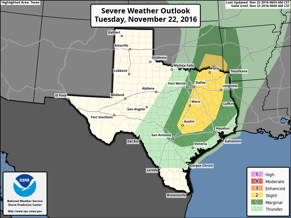
Meanwhile a strong disturbance over the southwestern United States will move east, toward Texas today. For our northwestern region, including the College Station area, the combination of daytime heating and the disturbance will create conditions favorable for some severe weather this afternoon through about midnight, or shortly before. There may be enough rotation to produce some isolated tornadoes and hail, but the primary threat is probably severe thunderstorms. (Fortunately daytime temperatures only in the mid-70s may limit some of the severity of storms). Here’s where NOAA’s Storm Prediction Center says the biggest threat will come later today:

(NOAA)
Severe weather outlook for Tuesday. (NOAA)

See full post

Space City Rewind: November 1992 Tornado Outbreak

Today, we’re launching a new series: The Space City Rewind. In this series, relying on various resources and historic weather data, we’re going to discuss historic weather events that have occurred in the greater Houston area. Although there are many fine books and articles in print, there’s limited, definitive information online about Houston’s turbulent weather history. We aim to publish informative, detailed, and insightful pieces on such events. With many new readers and residents in the Houston area, it’s helpful to understand our history and the range of severe weather that can affect those living on the upper Texas coast. We’ll talk about the meteorology, impacts, and share some interesting stories and photos.

We begin with the November 21, 1992 Southeast Texas tornado outbreak.

See full post

Storms possible this week before a mild Thanksgiving in Houston

Lows across Houston this morning range from around 40 degrees well north of Houston to the lower 50s along the coast. This morning caps an absolutely fantastic fall weekend for the region after the season’s first real norther. We’ll now warm up a bit for the week of Thanksgiving and have to watch for the possibility of some storms.

Today

Winds are calm at the surface this morning, but we’ve already started to see the return of an onshore flow from the Gulf of Mexico. This will lead to a mostly sunny, and warmer day with highs in the mid-70s across the area. It will feel a bit more humid, too. And lows tonight will only fall into upper 50s for inland areas, and mid-60s closer to the coast.

Tuesday

As moisture levels rise across the region, an upper-level system will approach the area from the west, and eventually bring a cold front through. However before that happens we’re likely to see a mostly cloudy day on Tuesday, with highs in the upper 70s. During the afternoon winds from the southeast could gust up to about 20mph during the afternoon with a pressure differential.

Severe weather outlook for Tuesday. (NOAA)

See full post

Cold front: It’s happening

Quick note: If you missed Eric’s post yesterday, we’re excited to be selling t-shirts so you can rep the site around Houston. We’re also accepting monthly sponsorships for 2017. Thank you to those who have pitched in. We’re so very grateful for your continued support and loyal readership!

On to the forecast.

It’s Cold Front Day! Today is also apparently Mickey Mouse Day. And Push-button Phone Day.  So why not make it Cold Front Day too? Who’s with me? Anyway, I digress. Let’s talk about how this unfolds.

Today & Saturday

Starting this morning, no serious issues in our area, but it is warm. Temperatures are in the mid to upper 60s to near 70 in spots, with mid 70s at the coast! But look north and west. The front is moving through the DFW Metroplex as of 6:30 AM.

Temperatures as of 6:30 AM show the front moving into the DFW Metroplex. (NOAA)

See full post