Hot, quiet weekend ahead, but forecast headaches loom

Hot, hot, hot! Thursday was the hottest day of the year so far in Houston. We hit 95°, which is right about average for our first 95° day of the year. Typically, our first 95° day occurs about June 13th (based on records back to the 1880s). Fun fact: In 1899, we didn’t hit 95° for the first time until August 8th! If only…

Today & Weekend

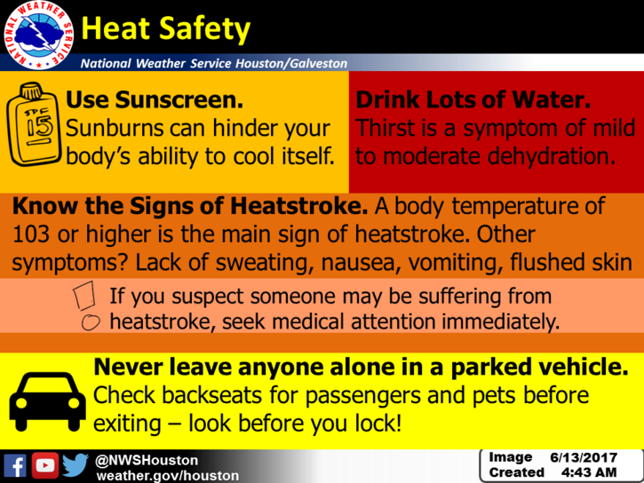
With our first 95° in the books, we’ll try and tack on at least one more this weekend. High pressure should dominate the next two to three days, keeping us mostly dry and hot. I suppose we can’t entirely rule out a stray downpour Friday, Saturday, or Sunday, but for the most part, the only detriment this weekend will be the heat. If you’re outside, make sure you stay hydrated, wear sunscreen and find some shade when possible. It’s very basic, common sense stuff, but it’s always worth a reminder.

NWS forecast highs are once again close to the middle 90s today. (Weather Bell)


All three days should see low to mid-90s for highs. Nighttimes will be sultry, with upper 70s in Houston and about 80 degrees along the Southeast Texas coast. Galveston will offer limited relief at night this weekend.

See full post

Warm ahead for Houston, with an eye toward the tropics

Good morning. Houston has clearly moved into a summer-like pattern of weather, and our weather won’t change much over the next several days. And we probably won’t change too much next week, unless an area of disturbed weather in the tropics migrates to the north. We’ll discuss that possibility below.

Today

There may be a few spotty showers across central and eastern portions of Houston today, but for the most part a building ridge of high pressure should shut rain chances down for the area. Look for mostly sunny skies with high temperatures in the low 90s.

Friday and Saturday

Warm and sunny, with highs in the low- to mid-90s, and overnight lows around 80 degrees.

Sunday through Tuesday

The high pressure that will largely dominate our weather from now through Saturday or so may slip away to the north by Sunday, opening up the possibility of some isolated or scattered showers during the daytime. Temperatures will be warm when it’s not raining, with highs likely rising into the mid-90s. That will be new for us, as the warmest it’s gotten so far this year has been 93 degrees (twice).

See full post

Heat building, rains ending, as summer solstice looms

As the reality of summer settles in for Houston, we can offer you one saving grace—the summer solstice is just six days away. June 20th will be the longest day of the year at 14 hours, 3 minutes. The Sun will be almost directly overhead during the middle of the day, at 84 degrees altitude. After passing the solstice, we’ll at least be able to begin counting down toward fall as days get a little bit shorter beginning next week. It’s a small hope, but the only hope we can offer at this point.

Today

High pressure will begin to build over the area today, but there’s enough moisture to still squeeze out a few showers for Houston, especially over the eastern half of the area. They will be scattered and likely brief. Highs otherwise in the low 90s.

Heat is building over the area. Here are some basic reminders. (National Weather Service)

Thursday through Sunday

June-like weather will prevail as high pressure builds over the region. That is to say, we’ll see high temperatures generally in the low 90s, lows in the upper 70s, with partly to mostly sunny skies and almost nil rain chances. 

See full post

Summer blahs for Houston with muggy nights and mornings

Houston is experiencing a typically steamy morning for this time of year, with lows in the upper 70s across most of the region. If you had forgotten, this is what summer feels like. And if I’m being honest, the lack of any real overnight cooling during summer is my least favorite part of the weather here.

Summer-time lows for Texas on Tuesday morning. (Weather Bell)

Tuesday and Wednesday

Warm, muggy conditions will continue for the region, with highs in the low 90s, and overnight low temperatures in the upper 70s. With decent atmospheric moisture levels, both days will probably see some scattered showers and thunderstorms during the afternoon and evening hours, but these will probably be short-lived.

Thursday through Saturday

As pressures rise, rain chances will go down toward the end of the work week. While I’m not entirely ruling out a chance of showers during the afternoon hours, for the most part these should be sunny, warm days in the low 90s, with warm nights.

See full post