Houston forecast: Mostly quiet, dry weather ahead

Sunday, 7:50am CT— Labor Day weekend rolls on and so does our mostly quiet weather. Given what’s needed for relief and recovery efforts across the region, this about as good a forecast as you could hope for in early September.

Today and Labor Day

Expect similar weather both today and tomorrow to what we’ve been seeing the last couple days. It should be mainly sunny, hot, and humid both days. High temperatures will top off in the lower 90s in much of the area. Morning lows will be in the low-to-mid-70s. We did have one or two very isolated showers around the area yesterday, and I suppose we could do the same today and tomorrow. But for the most part, the odds strongly favor you not seeing rain through Monday. Also, air quality will remain stagnant, so you’ll continue to notice haze in the area.

Tuesday and Wednesday

Gulf moisture begins to increase on Tuesday, ahead of our midweek cold front. As this happens, we should note a few more showers and storms in the area Tuesday afternoon and evening. Again, this won’t be serious stuff, and there’s a better chance that most of you won’t see rain.

Total rainfall through Wednesday morning’s frontal passage should average a quarter of an inch or less. (NWS/Weather Bell)

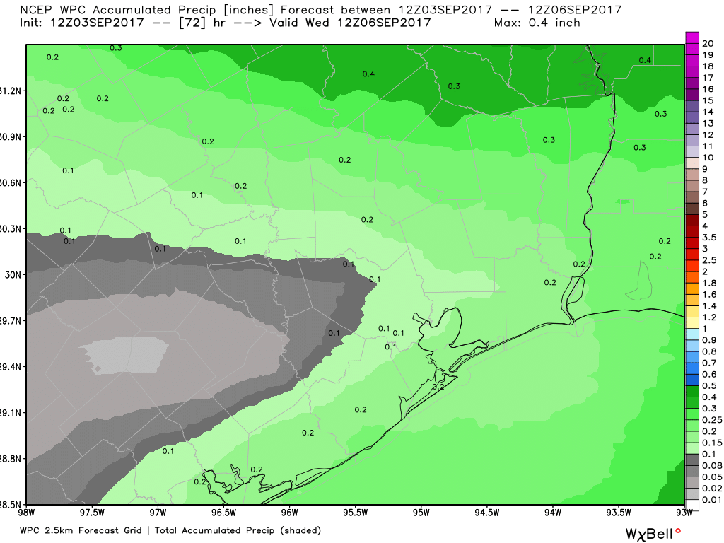
In fact, total rainfall through Wednesday morning should be about a quarter inch or less on average.

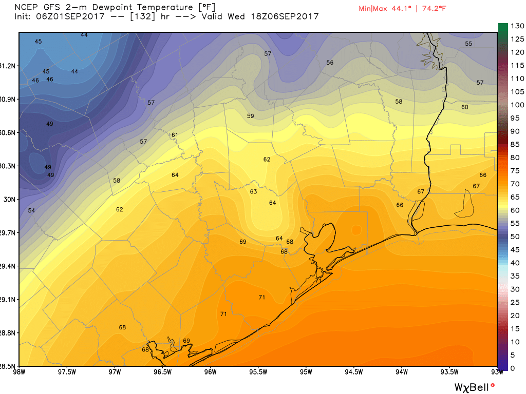
The front passes through the area from north to south Wednesday morning or afternoon, ending the rain threat and dropping dewpoints (humidity) from the 60s and low 70s into the comfortable 50s!

See full post

Houston forecast: Little rain, and a wonderful cold front

Saturday, 8:00am CT—As Houston settles into Labor Day weekend, we offer just a quick forecast for the days ahead. For early September, quite frankly, we’re going to have spectacular weather.

Saturday through Labor Day

Because tropical moisture is now expected to remain well offshore this weekend, we’ve lowered rain chances to near zero—with just a chance of a few scattered, sea breeze showers during the afternoon hours. Otherwise, expect mostly sunny skies with highs around 90 degrees. Normally during Labor Day weekend highs are in the mid-90s with very warm and humid nights.

Tuesday and Wednesday

An approaching cool front may nudge rain chances up a bit, while keeping highs in the upper 80s with some partly cloudy skies. Even if it rains, accumulations should be measured in tenths of an inch, and present no threat.

Low temperature forecast for Thursday morning. (National Weather Service)

Thursday through Sunday

We remain confident in the arrival of a cool front on Wednesday, which should bring wonderfully cool weather to the region for early September. We expect highs in the low- to mid-80s through most of the weekend, and overnight lows in the low 60s for inland areas, and upper 60s near the coast. The drier air will feel heavenly.

Tropics

No concerns for Texas at this time. We are now fairly confident that Hurricane Irma will turn northward before it can move into the Gulf of Mexico later next week. We also have some hope that Irma will turn before reaching Florida or the US East Coast, and thus spare those areas of devastating winds and surge. However, the final track of Irma is far from locked in, so areas from Florida to New York should continue to monitor the powerful storm closely.

Posted at 8:00am CT on Saturday, Sept. 2 by Eric

Mostly great weather in store for Houston

Friday, 7:30am CT—As widespread recovery efforts continue across the Houston area, we expect Mother Nature to aid the region in its recovery over the next several days. Amidst the terrible storm, one thing we failed to notice that fall is right around the corner. Well, it’s basically here!

Friday and Saturday

Nice, mostly sunny days, with highs of around 90 degrees. The chance of rain is near zero, and nighttimes should continue to be pleasantly cool—lower 70s—for this time of year.

Sunday through Tuesday

As some moisture returns into Houston from the Gulf of Mexico, we should see an increase in clouds, from a few scattered clouds on Sunday to partly to mostly cloudy skies on Labor Day. This will bring some decent rain chances to the area, especially on Labor Day and Tuesday. But at this time we remain pretty confident that we’ll be measuring accumulations in tenths of an inch rather an inches themselves. Clouds should keep highs in the upper 80s.

Dewpoint map for next Wednesday, at noon, shows the GFS model forecast for the cold front location as it moves southeast. (Weather Bell)

See full post