If you’re only interested in Houston weather, you can skip this post. We are not going to see much rain over the next 10 days, and temperatures will generally be pleasantly cool for early September. However, we’ve had a lot of requests from readers to continue coverage of Hurricane Irma, due to the significant threat it presents to the United States. (Already, with winds of 185-mph, the storm is the second-strongest in the Atlantic basin on record). So that’s what we will provide here.
Having looked at the forecast model guidance that has come out during the last two hours, the we can have pretty high confidence in the hurricane’s track through about Friday, when it will be in the vicinity of Turks and Caicos (a beautiful area, which I hope survives this storm). After that I want to highlight three possible scenarios, neither of which I have particularly high confidence in as so many unanswered questions remain: When does Irma find the western periphery of the Atlantic high pressure system and turn north? Does it turn northwest, due north, or northeast? And how much does the storm’s center interact with Cuba? All of these questions will have profound effects.
Harvey was an incredibly emotional forecast that challenged many of us in ways we’ve never been challenged before. In writing this personal retrospective I sought a way to process this experience and convey the emotion of the last couple weeks in words. So this is my story, my call to action, my open letter to the city I’ve come to love.
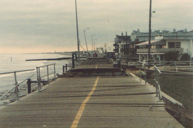
I grew up in New Jersey and became fascinated by weather, most likely at the age of three. The memories are broken up and fuzzy now, but they’re firmly in my mind. In 1985, Hurricane Gloria came barreling up the Eastern Seaboard, forcing my family to evacuate my grandmother from her home in Atlantic City. My dad taped up windows around our house about four miles inland from the shore. I remember going to the coast after dark as the storm pulled away to (perhaps my parents would now admit, unwisely) “assess damage” to the beach. Gloria’s impacts on the Jersey Shore were modest. My grandmother’s house was unscathed, and life got back to normal in short order. Somewhere along the line Gloria ignited a passion for meteorology. It started with a hurricane in New Jersey, and as I sit here 32 years later, I openly wonder if a rain-laden hurricane in Texas is what extinguishes it.
Boardwalk damage in Ocean City, New Jersey from Hurricane Gloria. (Wikipedia)
I’ve dealt with a few stressful forecasts in my career. There have been blizzards when I worked in Upstate New York. Hurricane Irene in 2011 had me considering telling my parents to evacuate the same home we shored up for Gloria. In 2012 came Sandy. I had many friends and family members back in Jersey and New York directly impacted by that storm. The lead-up to that storm was one of the most stressful I’ve dealt with, though now a fading second to Harvey. At the time I worked as a meteorologist for the energy trading arm of Deutsche Bank here in Houston. My boss was on a required two week leave, and the onus fell on me to prepare our New York City office for Sandy’s impacts. I remember conference calls, and giving a worst-case scenario forecast I didn’t really even grasp. Sandy was the storm that, as a passionate weather geek, I drew on a map as a kid that wasn’t ever supposed to happen. It was difficult to see the Jersey Shore, my homeland, so ravaged. But my life had brought me to Houston by then, so there was a buffer there to reduce the storm’s emotional impact. But it remained difficult to watch.
Life had indeed brought me and my wife to Houston. We moved here in 2012 after stops in Jacksonville, Southern California, and Upstate New York. Maybe it’s because I somehow grew up deep in Philadelphia Eagles territory as a Warren Moon and Houston Oilers fan (not kidding here at all, I have the 1990s-era Starter jacket to prove it), but I have always had an affinity for Houston. I had no family here, and the first time I visited was on a job interview in 2008. As a broadcast meteorologist in Upstate New York, I had decided that the route I wanted to steer my career toward involved the energy industry. After discussing it over a long period of time with my wife (then fiancée), we decided that Houston would be our goal. It took a few more years, but we arrived in 2012, a year or so after my wife’s brother moved here. My wife’s parents wouldn’t be far behind. Houston didn’t become a home. It became our home.
A cold front remains on track to reach Houston on Wednesday, arriving a couple of weeks early to the region, and bringing some genuinely fall-like weather to the upper Texas coast. I’ll also discuss Hurricane Irma, because the storm has reached Category 5 status and almost certainly will have some devastating effects in the United States. We remain pretty confident the storm won’t have major effects for Texas, however.
Tuesday
We’ll still be pretty warm today, with highs in the low 90s across Houston, but for early September this is still decent weather. Houston could see some scattered showers later this afternoon, but for the most part we should be rain-free.
Wednesday
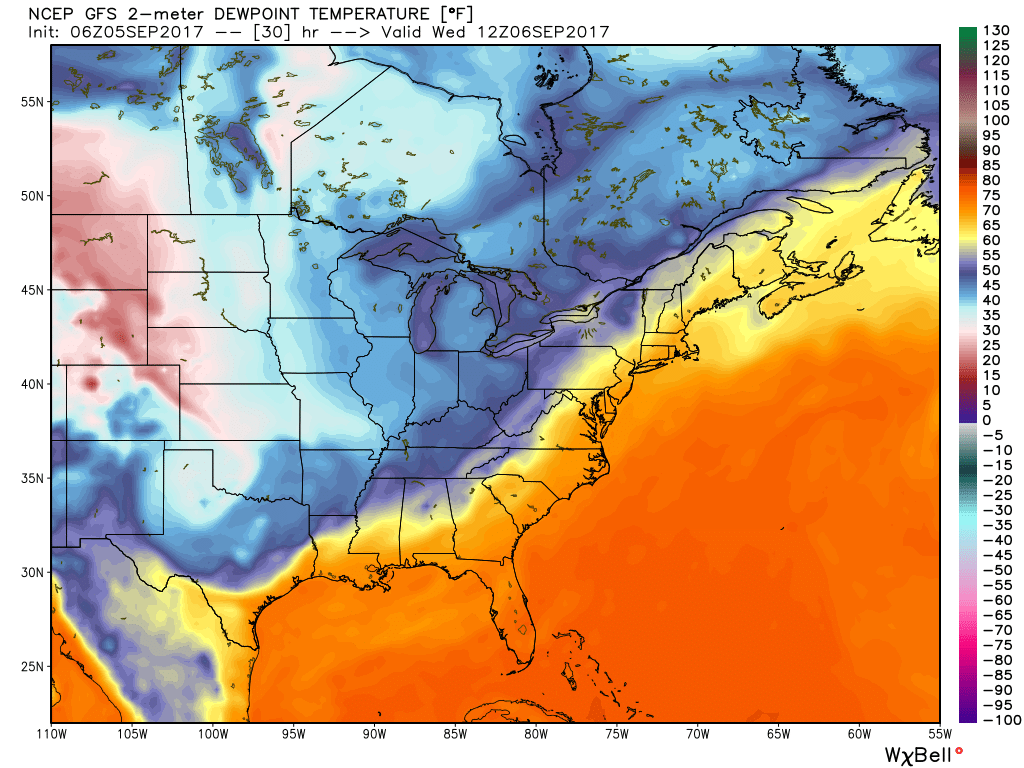
Cold front day! It’s almost like a holiday here in Houston. Moisture levels will increase a bit before the front moves through on Wednesday, most likely during the late morning or early afternoon hours. Some scattered showers are possible with the front—a few isolated areas could see as much as half an inch of rain—but for the most part this should be a breezy passage rather than one with thunder and lightning. Humidity should fall off a cliff after the front moves through, making for a pleasant evening.
Forecast map showing dewpoint temperatures on Wednesday morning. The front is almost to Houston. (Weather Bell)
Thursday through Sunday
We’ll have some great September weather after the front comes through, with highs generally in the mid- to upper-80s, overnight lows in the 60s (perhaps upper 50s for some inland areas and closer to 70 degrees along the coast). The drier air and full sunshine will feel fine.
Good morning. I hope everyone is finding some peace on Labor Day morning. Our short-term forecast remains more or less locked in for the Houston area, with warm-ish days through Wednesday (highs in the low 90s) before a cold front moves through and brings absolutely splendid weather for the second half of this week. We may see some decent rain chances on Tuesday and Wednesday due to the approaching front, but even so most areas probably won’t see more than about a tenth of an inch of rain (if that).
With that said, we’ve had a lot of questions about the tropics—understandably people are still pretty skittish after our brush with Hurricane Harvey. We get that. So here’s a review of what’s out there. Also, I’d like to remind everyone that while the Atlantic hurricane season officially lasts until Nov. 30, for Texas is effectively ends in about three or four weeks. We are almost there, folks.
Hurricane Irma
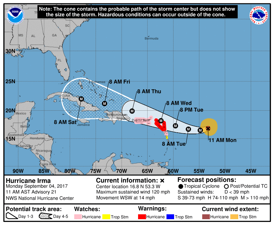
All eyes are on Irma, a major hurricane with sustained winds of 120mph moving toward the Northwestern Caribbean Sea. It should reach the vicinity of Puerto Rico by Wednesday night, and poses a significant threat to the Caribbean Islands. Here’s the latest (10am CT) track forecast from the National Hurricane Center.
Understandably there is a lot of concern about where the system goes in five to seven days, when it begins to approach Florida and the continental United States. There has been a westward movement in the forecast models over the last day or two, leading to some local concerns that the track may continue to shift westward toward a Texas landfall. We continue to remain pretty confident that is not going to happen.
With that said, the storm’s movement after about Thursday is fairly uncertain. Generally, the ensemble members of both the European and GFS models show the storm moving west-northwest just north of Cuba, and making a turn north just before reaching Florida, over Florida, or just after Florida (into the eastern Gulf of Mexico). Irma is expected to make this northern turn after it finds the western edge of a large ridge of high pressure over the Atlantic region, but at nearly a week from now it’s impossible to determine where that will be.