I’m hopeful Houston will have one partly sunny day this week

As brutal as it sounds, Houston may have just one partly sunny day during the next seven days—with the rest of our weather being mostly cloudy. But if that’s got you feeling blue (unlike the sky), just remember that for all of December, the city of Moscow saw only six minutes of sunshine. So as ever, it could be worse.

Tuesday

In a word, gloomy. The day will start chilly, in the low- to mid-40s for most of Houston. With widespread clouds holding on, we should see highs only in the mid-50s on Tuesday, and as moisture levels start to rise later today, we should also see some light to moderate rain showers—but accumulations shouldn’t be an issue. Low temperatures on Tuesday night will basically remain flat from the day’s highs, as warmer air moves into the region.

Wednesday

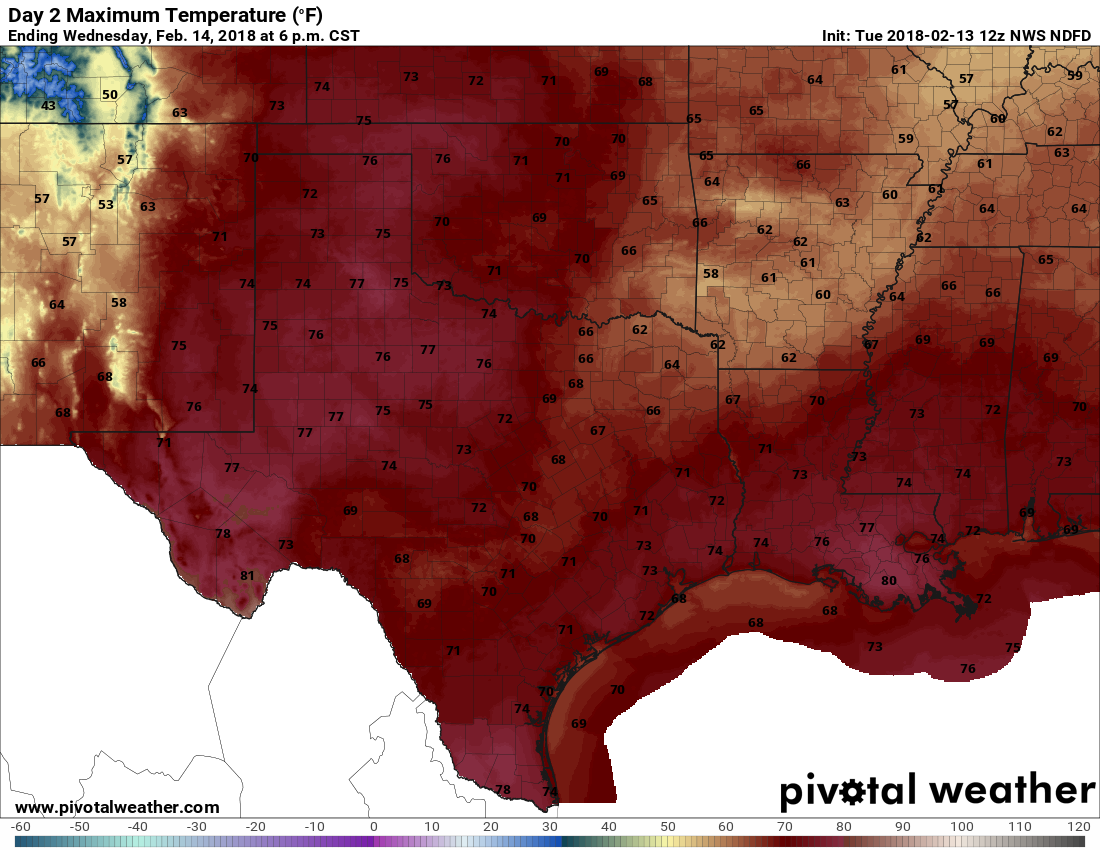
The warmer air will do its work and, despite mostly cloudy skies, we can expect high temperatures to climb into at least the low 70s on Wednesday.

High temperatures will rebound nicely across the region. (Pivotal Weather)

Some slight, scattered rain showers are possible, but by no means certain. Lows Wednesday night should only fall into the mid-60s. If you’re planning some kind of outdoor activity for Valentine’s evening, I think the weather should mostly cooperate.

See full post

The Sun to remain a stranger for most of this week in Houston

It is quite cold this morning across Houston, with lows ranging from the mid-30s across northern portions of the region to around at the coast. The good news is that we’ll see warmer temperatures for the rest of this week—but the bad news is that the Sun is going to remain mostly a stranger to our skies.

It’s a very cold start to Monday in Texas. (Weather Bell)

Monday

A slight northerly wind, in concert with cloudy skies, will keep Houston on the cool side. I expect highs today to remain at about 50 degrees. So, a cold morning, and a cold day. Low temperatures Monday night will probably be about 10 degrees warmer than on Sunday night, however.

Tuesday

A bit warmer than Monday, but cloud cover should again help to keep temperatures bottled up in the 50s. Temperatures may not reflect it, but higher moisture levels will be returning to the area, and we could see some scattered, briefly heavy showers throughout the afternoon and evening hours on Tuesday. For the most part I wouldn’t be concerned with accumulations, as they should only measure at a few tenths of an inch.

Wednesday and Thursday

Some slight rain chances remain, but the bigger story on Wednesday will be the movement of warmer air into the region from the south. Despite clouds on Wednesday, we should see highs in the mid-70s, and these temperatures could reach 80 degrees on Thursday with (hopefully) some partly sunny skies. Nighttime temperatures should only fall into the 60s. By the way, Houston has yet to officially hit 80 degrees in 2018.

See full post

Heavy rain possible on Saturday morning in Houston

Sorry for the late post this morning. I’m still traveling, and Matt had some other business to attend to this morning. We’ll be back to our regular schedule next week. In the meantime, I’m unhappy to report that Houston’s weather still looks fairly lousy.

Friday

As the onshore flow ramps back up today, we can expect to see warmer conditions, with high temperatures near 70 degrees. There’s the possibility of a few scattered showers later this afternoon, but for the better rain chances we’re going to have to wait for tonight and Saturday.

Saturday

Ugh. We’re going to see a spike in atmospheric moisture levels beginning Friday night and into Saturday morning, and in combination with divergence over head (which allows the warm, moist air at the surface to rise), we’re going to see a really healthy chance of rain showers beginning Friday night and through part or most of the day on Saturday.

A surge of moisture (shown here in precipitable water) will move into Texas and Louisiana on Saturday morning. (Pivotal Weather)

Right now the best chance of heavy rain seems likely to come on Saturday morning, when a few areas could see some rainfall rates of 1 to 2 inches per hour during the heaviest storms. This could be enough to cause street flooding, so please take care if you plan to be out and about. Overall, I’d anticipate widespread accumulations of 1 to 3 inches, which higher isolated totals possible. Highs Saturday will be around 70 degrees again. We’ll watch the potential of flooding for you, and update if needed.

See full post

At least some sunshine likely today in Houston

BREAKING: The clouds. Maybe. More on that below. If you’ve noticed that it’s been a lot drearier than normal this month, you have statistics available to back you up.

This image is off of a cool site from Iowa State that has all sorts of climate and weather nuggets.I admittedly cherry picked an hour here, but other hours show some variation on this also. The link should show 3PM, which has had overcast skies reported every day this month so far. It’s been grey and dismal, and as much as I want to tell you we have a nice, lengthy stretch of good weather upcoming, we don’t.

Today & Friday

All that said, clouds have broken up some and we’ll have a half-decent day today. Satellite shows cloud cover mainly in the southeastern half of our area this morning.

Satellite this morning shows southeastern areas are still pretty socked in with clouds. But clearing has moved into northern areas. We will see at least some sun in most spots today. (College of DuPage)

Based on the movement of the clouds, I suspect we’ll actually have more clearing today than I initially expected. We’ll call it partly cloudy to mostly sunny. Expect highs to top off in the upper 50s or so. Clouds will gradually thicken back up tonight and onshore flow will resume, allowing temperatures to not fall as much. We won’t get below the upper 40s this evening and may even rise a degree or two toward morning.

Onshore flow will continue to increase on Friday, pumping back in moisture and solidifying clouds overhead. It looks as though we’ll see showers also increase throughout the day, especially south of I-10. Expect temps to slowly, steadily warm on Friday into the mid-60s.

See full post