A wintry feel to Wednesday

Welcome back to Houston winter. Today will be a rude awakening for anyone who enjoyed our 70s yesterday. Let’s jump in.

Today

First off, the cold front is through the entire area already this morning. Temperatures aren’t going very far today. We’ve sunk into the 40s, and we should stay there for the balance of the day, though we may go from mid-40s this morning to upper-40s this afternoon. Either way, have a coat available today.
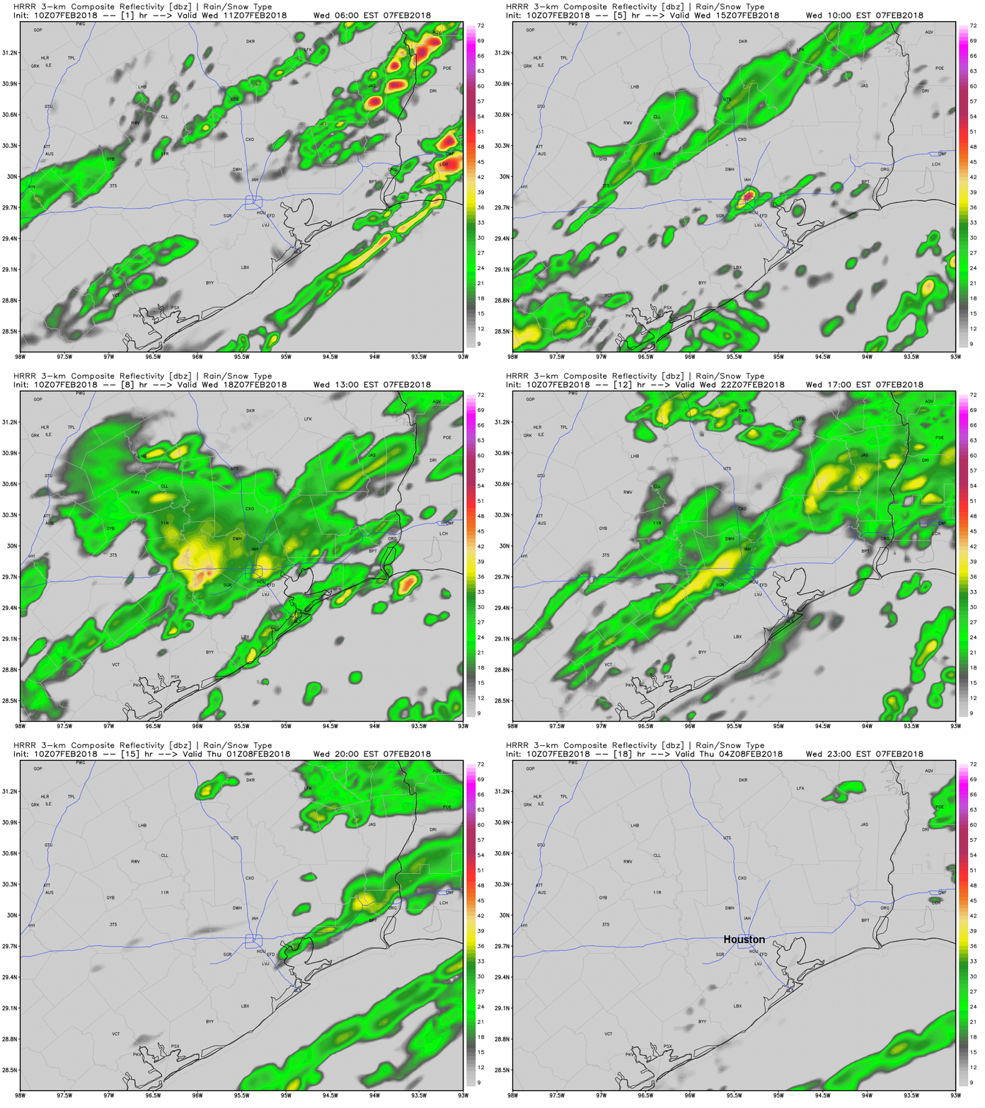
The HRRR model shows scattered showers and a few embedded thunderstorms continuing throughout the day today before gradually winding down after sunset this evening. (Weather Bell)

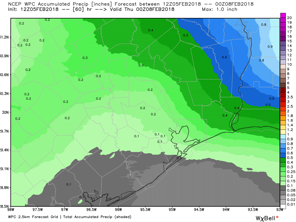
Also, have an umbrella. Rain and and a few thunderstorms will be likely throughout the day. Coverage is sporadic this morning, and that should actually increase as the day goes on. I wouldn’t rule out some small hail in any thunderstorms today with cold temps in place. Rain totals will be variable, with some folks seeing as much as a half inch, while others may only see a tenth of an inch or two. It will also be a bit breezy today.

Tonight & Thursday

Rain should end this evening. Skies may clear out tonight in spots well north. But I think we’ll stay mostly cloudy in Houston. This will help us avoid a light freeze. Folks up near Conroe or Crockett may see temperatures get into the lower 30s, but that won’t happen in Houston. Expect lows in the city to bottom out in the upper 30s to near 40 degrees or so. Just a little wind around tonight will make it a bit colder.

On Thursday, we start the warm up process again, so expect clouds to stay mostly in place, though we hopefully see some sunny breaks. The better chance of sunshine tomorrow may be north of I-10. But overall, the day should be dry and quiet. Temperatures will make a respectable effort to get close to 60 degrees, but likely come up short.

See full post

Houston to get wet this week, and weekend

Good morning, everyone. It will be a fairly quick post this morning, as Matt is traveling, and I’m in Florida for the Falcon Heavy launch, which may liftoff as early as 12:30pm CT today. (If you’re interested check out these photos of me and Elon Musk near the launch pad on Monday).

Tuesday through Wednesday morning

A warm front has essentially stalled along the coast, and this is creating foggy conditions across much of the area, which may linger into the mid-morning hours. “Clearing” skies is a relative term, as skies will remain cloudy throughout the day. As that warm front lifts back north, it will generate some showers and probably some thunderstorms later this afternoon across the area, with the greatest potential for severe weather to the north-northeast of Houston. I expect most areas will see about one-half inch of rain today, give or take, as temperatures top out at about 70 degrees.

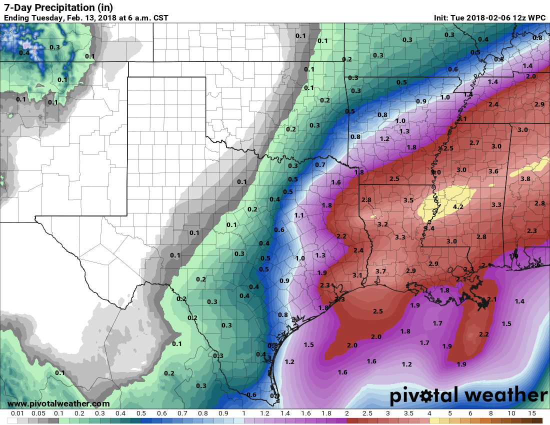
It will be a wet week for southeast Texas, with much of Houston picking up 1-3 inches of rain from now through Monday. (Pivotal Weather)

Wednesday

A cold front will push through the region early on Wednesday, likely moving through the city by or before sunrise. This will not immediately scour the rain chances from Houston, however, and I expect most of the region to pick up another half inch of rain, or so, before the region finally begins to dry out later on Wednesday, or Wednesday night. Temperatures will be quite a bit colder behind the front, so look for readings only in the low 50s on Wednesday after the front moves through.

See full post

Late winter roller coaster ride for Houston

One question I’ve noticed from several folks in recent days has been some variant on “is it safe to tend to the garden yet?”

While we’ll probably avoid any sort of serious cold over the next 7-10 days, the advice I’ve been giving people is to give it at least another week or two. There’s a lot of uncertainty in the weather forecast going into mid and late February, and I’m just not convinced we’re completely out of the woods here in the area. Frosts can cause issues; it doesn’t take 20 degree weather to be problematic. On average, Houston’s last sub-32 degree morning is around February 15th. We’ve done as late as April 10, 1973, and, more recently, as late as March 21, 1996. Yes, it can get cold well into March here. As much as we’d love to say yes, go ahead and get busy, it’s probably prudent to just sit tight a little longer if you can. This winter’s surprised us more than once. We’ll keep you posted.

On to the forecast.

Today through Wednesday

After a mild Sunday, we’ll start the week just a bit cooler behind yesterday’s cold front. Look for upper 50s under clouds or lower 60s with more frequent sunshine today. We’ll have more clouds than sun in general, and a few sprinkles or pockets of drizzle could develop this afternoon, especially south/east of US-59. Onshore flow will continue to ramp up tonight. That should mean more clouds, showers, sprinkles, and also some fog around heading into Tuesday morning.

On Tuesday, we’ll have a warm air mass in place, along with increasing Gulf moisture. This should set the stage for scattered showers and perhaps some thunderstorms across the area. I don’t think everyone will see thunderstorms, but there is a chance for some stronger, hail-producing ones, primarily north of I-10 later Tuesday into Tuesday evening.

Expect temperatures on Tuesday to warm from around 60° in the morning to around 70° later. Tuesday night should see the best chance of storms shift a little further north of our area. A cold front will finally approach the area on Wednesday, cutting northwest to southeast Wednesday morning. We’ll start Wednesday probably in the mid 60s, but by midday or so, temperatures will likely drop back into and through the 50s. Plan to dress for two seasons on Wednesday. With the front, expect another round of showers and a chance of thunderstorms in the morning, and a continued chance of showers or some storms through the afternoon.

Total forecast rainfall over the next couple days shouldn’t be too serious, though a few places will likely see just a little bit more than depicted here. (WPC/Weather Bell)

On average, expect a quarter to half inch of rainfall through Wednesday evening. Some areas may see a little more if showers and storms are persistent. As noted on the map above, some areas south of Houston could even see a bit less.

See full post

Cooler, cloudy, winter-lite type weather today

Today will be one of the Houston days I like to call “Winter-Lite.” It’s definitely chilly by Texas standards, but it’s really not going to be frigid. We’ll have some ups and downs in the days ahead. We’re also watching Texas slip deeper into drought. More on that at the bottom of the post.

Today & Weekend

Our cold front slipped through the area overnight. Rain chances should be minimal to near zero today. Basically, today looks mainly cloudy, breezy, and chilly with temperatures stuck in the lower or middle 50s.

If you have outdoor plans this weekend and can choose Sunday over Saturday, that’s the right play. Tonight will start quiet with just some clouds. The Gulf will see a trough and warm front develop and begin to push back toward us. As it does so, a couple of disturbances several thousand feet up will approach from the west. The combination of these features will likely lead to showers developing overnight.

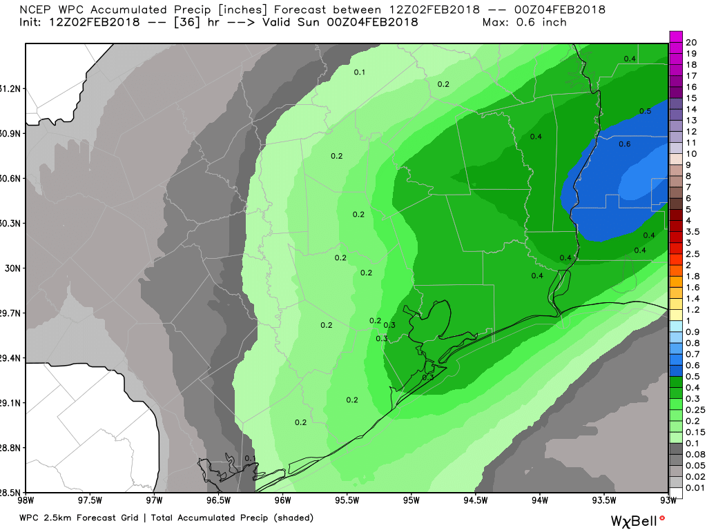
Unfortunately, I think this means Saturday will be damp. Look for showers, periods of rain, or even a thunderstorm to persist through Saturday morning and into the afternoon. How much rain? I’m thinking around a quarter inch in most spots, maybe a little less south and west or more north and east.

Total rainfall through Saturday evening should be around a quarter inch, with higher amounts possible, mainly east of US-59. (WPC/Weather Bell)

Last weekend sort of snuck up on us, and while model guidance has trended slightly rainier this weekend, I don’t think we’ll see nearly as much rain as we did last Saturday. So we’ll call Saturday a damp one, but not as wet as last weekend.

Temperatures should warm through the 50s during the day, perhaps getting into the 60s by later in the afternoon tomorrow. Look for fog (especially at the coast) on Saturday night into Sunday morning. I’m skeptical of rain chances Sunday. Rather, I suspect we’ll see clouds and/or fog in the morning gradually yield to sunshine, with temperatures warming into the 70s. A weak cold front on Sunday will allow temps to drop back into the 50s heading into Monday morning. More fog is possible at the coast Sunday night.

See full post