Willa to make for a wet, but not too wet week in Texas

After a fine (so very fine) Sunday of fall-like weather in Houston, our gray, wet weather returns as early as later today. Part of this is due to moisture from Hurricane Willa in the Pacific Ocean, but as for now we aren’t overly concerned about excessive rains from this system on Tuesday and Wednesday in Houston. Finally, we should clear out for a pretty darn nice fall weekend.

Monday

Clouds will return today, as moisture streams in from the southwest. Some scattered showers are possible today, but better rain chances arrive tonight (around 70 percent for coastal areas, and 50 percent inland) along with low pressure along the coast. Most of the region will probably see less the one-half inch of rain during the overnight hours. Highs Monday will probably remain in the upper 60s.

Tuesday and Wednesday

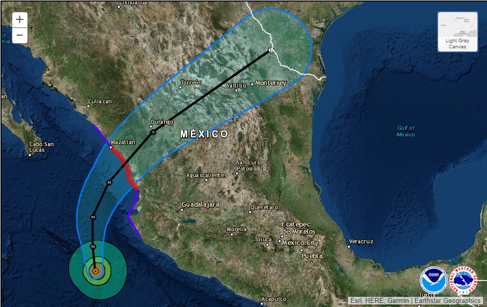
Our mid-week weather will be driven somewhat by Hurricane Willa, which should make landfall on Tuesday along the Western coast of Mexico, north of Puerto Vallarta. This is a powerful hurricane on Monday, with Category 4 winds, but Texas should only see rains and some moderately gusty winds from the storm as it weakens over Mexico and brings moisture into the United States later on Tuesday and Wednesday.

Hurricane Willa should make landfall on Tuesday. and weaken as it moves across Mexico (National Hurricane Center)

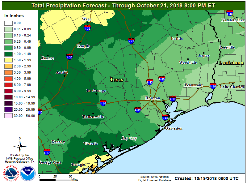
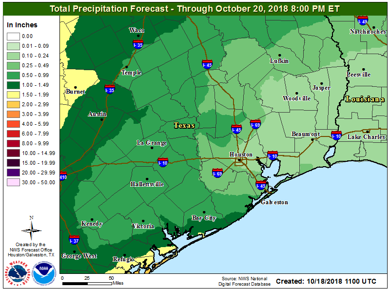
How much moisture? We’ve received several comments from readers about concerns expressed elsewhere about heavy rains in Southeast Texas. Even the most bullish members of the European operational model peak out at about 4 inches of rainfall for Houston, and most of them are in the 1-2 inch range. So that this time we don’t anticipate widespread problems, just fairly grim mid-week weather for Houston. (We have greater concerns about central Texas, where accumulations should be about the same, but where some historic flooding has already occurred this month.)

See full post

Friday night might be soggy in spots

Eric and I just wanted to provide a quick update to you tonight because the forecast has been a little tricky here.

Most of today has gone as expected. But the warm front that was supposed to hang around or south of I-10 into tonight has lifted a bit further north than expected, and is currently approximately straddling US-59. It also hit 80 degrees at both Hobby and Bush (81) today. The air mass over us is plenty conducive for heavier rain at times. That said, radar shows scattered showers and storms west and north of Houston as we told you would be the case this morning.

Scattered showers and storms are rumbling along west of I-45 this evening. (GR Level 3)

Some of this rain is fairly heavy. Thankfully, everything is moving along at a healthy clip so far, so it won’t rain too hard in any one location for too long.

The forecast from this morning deviates a bit from this point into the first part of Saturday. There have been some indications from various weather models this afternoon and evening that some areas around and southwest of Downtown Houston would see repetitive rounds of showers and storms through the night. The latest version of the HRRR model shown below also indicates this to some extent.

The HRRR model from late this afternoon shows some repetitive shots of showers and storms this evening and overnight in the Houston area. (Weather Bell)

Earlier runs of this model were a little more bullish on rain, but nonetheless, you get the idea.

So what does it mean? Neighborhoods primarily south of I-10 and west of I-45 stand the risk of seeing a few rounds of heavy rain and thunderstorms this evening and overnight. Rain amounts could be locally impressive in spots, on the order of 1-3″ (most of us will not see that much rain). If everything moves any slower than we expect right now, 4-5″ of rain could be a possibility in a neighborhood or two.

At this point, Eric and I don’t see serious flooding concerns tonight. Localized street flooding is always a possibility in the Houston area, but we just want you to be aware of a slightly wetter forecast in the region than perhaps was expected. And with folks out and about on a mild Friday night, we want you to know that some area football games could be dealing with some rain or lightning delays. If something changes to make this any more serious over the next few hours, we’ll let you know. But, again, we don’t feel that will be the case.

Cloudtober marches on

After a disappointing end to the Astros season, we could use a little sunshine around here to perk us back up a bit. Unfortunately, there’s not a lot of great news looking ahead. We just offer thoughts on the forecast; we don’t control the weather. But we apologize nonetheless.

Today

Today will be another day of clouds and perhaps a couple sunny breaks in spots if you’re lucky. For those of you that missed warmer temperatures, you’ll be seeing some of those return today too. We crested into the 70s in Houston early yesterday afternoon, and we are already running about 10 degrees warmer than yesterday morning (mid-60s). So we’ll probably push the upper-70s today.

Radar as of 5:30 this morning showed heavy rain in spots from Matagorda Bay south to Corpus Christi Bay. (College of DuPage)

There will be a chance of showers and storms virtually anywhere at anytime, but as radar shows, the heaviest rains are likely to stay south of Houston. The Matagorda Bay region has seen the steadiest rains, but so far most places have only seen a quarter to a half-inch or so. As we go into this afternoon, the focus for the best rain or storm chances may shift to west or north of Houston.

Weekend

Our next cold front is in line to cross through the area later Saturday afternoon or evening. Expect a mild, somewhat muggy Saturday morning, with AM lows in the 70s south and east of Houston and mid-to upper-60s north and west. We’ll probably have scattered showers tonight into Saturday morning across the region. Not everyone will see rain though. As the front approaches during the afternoon, we will have another shot at some showers. I am not too impressed by the dynamics of this cold front as it approaches our area, so I am not terribly worried about any significant weather as it passes by. Rain chances will trend toward zero on Saturday night finally.

Most of the Houston area is expected to see a half-inch or less of rain this weekend. By Sunday evening, some areas toward Central Texas or down around Matagorda Bay may see over an inch of rain. (NWS Houston)

Expect temperatures ahead of the front to peak in the mid-to upper-70s south and east. Areas that see an earlier passage of the front north and west of Houston may not get much past the low-70s.

See full post

Oh Mr. Sun, Mister Golden Sun, please shine down on me

Our wet, but not too wet, and cool, but not too cold pattern will continue for the foreseeable future in the Houston metro area. One thing we can guarantee is that while the Sun does exist, there will be little direct evidence of it over the next week. Clouds, and more clouds, will rule the skies.

Thursday

We’ve seen some light to moderate showers in Montgomery County early this morning, but these should exit the region to the north shortly after sunrise. Scattered showers will be possible today, but accumulations should be slight. High temperatures will be warmer than in recent days, likely around 70 degrees, although any regions that do see short breaks could push into the mid-70s. For the most part, just another gray day.

Friday and Saturday

The story heading into the weekend will be surging moisture levels along the Texas coast, and moving inland. For now, the most likely scenario is that these heavier showers remain well to the south of Houston, most likely in the Corpus Christi area, and staying well to the west of Houston. (The hard hit Austin region, where Lake Travis is nearing record levels, could well see more heavy rain this weekend.)

Rain accumulation forecast for now through Saturday evening. (National Weather Service)

For Houston this means a healthy chance (probably around 50 percent) of showers on Friday and Saturday as this moisture moves inland and meets up with an oncoming cold front. For our city and surrounding areas, accumulations are likely to be measured in a few tenths of an inch, but we can’t rule out some heavier isolated storms.

See full post