Dreary weather continues, but we’re holding out hope for Sunday

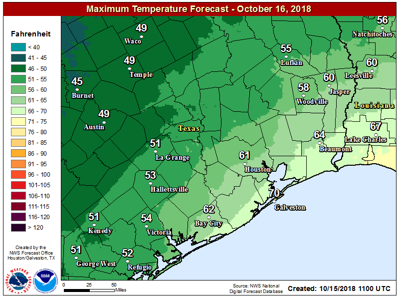
It’s another cool morning across the region, with highs generally ranging from the 50s up north to the lower 60s along the coast. It is hard to believe we reached 91 degrees only on Sunday, but fall truly has come. Some inland parts of the region may not hit 80 degrees for the rest of this month, although after today we’ll see a moderate warming trend for a few days. If you’re tired of the gray weather, Sunday is your best hope.

Wednesday

Today will probably be similar to Tuesday, with mostly to completely cloudy skies, highs only around 60 degrees for northern areas, and mid-60s for the city. For better rain chances, we’ll need to look to areas far north of the city (i.e. north of College Station or Huntsville) and along the coast and offshore. Chances in Houston will probably be in the 20 to 30 percent range, with what does fall coming down mostly as light mist or drizzle. So basically, another gray day.

Thursday and Friday

Mostly cloudy skies continue, under a northeasterly flow. There’s plenty of moisture toward the second half of the week for the atmosphere to work with, so we’ll probably see more widespread light to moderate rain for Thursday and Friday.

High temperatures should get back into the 70s for most of Houston by Thursday. (National Weather Service)

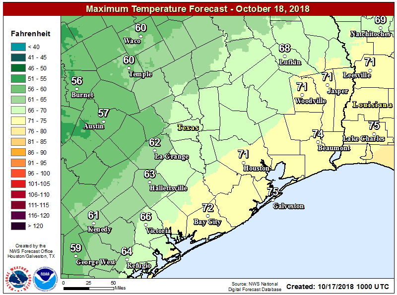
Accumulations, for the most part, should be measured in tenths. Highs should manage to make it into the low 70s, which is still about 10 degrees below normal levels for this time of year.

See full post

Houston gets a taste of Seattle weather for awhile

Temperatures are generally 20 to 25 degrees cooler this morning across the Houston metro area, with lows in the upper 40s for far inland areas near College Station, in the 50s for most of Houston itself, and the lower 60s along the coast.

Temperatures across the Houston area at 6:15am CT Tuesday. (National Weather Service)

After the influx of colder air, what you see with our weather now is basically going to be what you get. We’re probably stuck with mostly to completely cloudy skies for the rest of this week, and we may see some periodic stormy activity like we saw on Monday.

Tuesday

This will be the region’s coldest day in at least six months, with cloudy skies and high temperatures generally in the low 60s for Houston, and 50s for some inland counties well away from the coast. Rain chances will not be too high today, I’d peg them at around 30 percent, with heavier showers likely remaining well to the north of the area, or offshore. All in all, this will be a rather dreary day. (Until the Astros win this evening, of course).

Wednesday and Thursday

Not much changes for the middle part of this week, with a cooler air mass near the surface, and warmer above, allowing for a thick cloud deck and continued moderate rain chances. All told, I’d expect most of the area to pick up about one-half inch—totals will be highly dependent upon very localized storms—of rain over the next three days. High temperatures will warm into the upper 60s and low 70s for the region.

See full post

Houston has had its last 90-degree day of 2018

On Sunday, the high temperature at Bush Intercontinental Airport reached 91 degrees. This came to within one degree of the all-time record for Oct. 14, set in 2015. We can consider this the last hurrah of summer for 2018, as fall will more fully assert control this week, and seems unlikely to relinquish its grip completely in the weeks ahead. I can confidently predict that we will see no more 90-degree temperatures this year given the overall cooler outlook for the next two weeks. (The latest 90-degree day on record in Houston came on Oct. 29, 1991).

Monday

Today, our weather will make a dramatic shift from summer into serious fall-like conditions. By 7am a cold front had already pushed through northern areas such as Huntsville and Conroe, and should move off the coast by around noon today. What will follow can probably be best described as Seattle-like conditions, as temperatures fall from the mid-70s this morning across the region into the 60s this afternoon, and 50s tonight.

This will not be a classic blue-norther front, as the cold air mass is rather shallow, and this will allow plenty of clouds to form a few thousand feet up in the atmosphere, and this essentially means that we’ll have on-and-off rain showers later Monday, Monday night, and Tuesday.

Tuesday

Houston’s last high temperature of 60 degrees, or below, came back on April 8 when a strong cold front hit the region. A portion of the region may not reach 60 on Tuesday, as clouds blanket the region with intermittent rainfall.

Tuesday’s high temperature forecast, ladies and gentlemen. (National Weather Service)

We may see some brief, localized heavy showers but for the most part rain amounts will be completely manageable. Conditions will be dreary out. Fireplaces may be needed inside. Dare I say it will feel almost winter-like out there?

See full post

Warmer this weekend, then a stronger cold front for Houston

Temperatures have fallen nicely this morning, generally into the upper 50s and low 60s for inland areas, and mid- to upper-60s closer to the coast. A pre-sunrise step outside felt entirely refreshing after our five months of summer, and truth be told we have even cooler weather on the way. A front that should reach the metro area is already bringing snow to the Texas Panhandle. It won’t get that cold here, of course.

Friday

I hope you enjoyed Thursday, because we’ve got a similar day on tap for Friday, with splendiferous highs in the low 80s, mostly sunny skies, and relatively low humidity. Alas, dewpoints will be on the rise later today as the onshore flow returns, and we’ll be looking at temperatures about 5 degrees warmer tonight, with a corresponding rise in humidity overnight. Our first taste of fall may have been fleeting this year, but we’ll have more of a feast in a few days.

Friday night’s lows won’t be nearly so cool as Thursday night. (National Weather Service)

Saturday

This should be a reasonably nice day, with high temperatures in the mid-80s and partly sunny skies. Southerly winds will continue, kicking up humidity levels. We can’t rule out some scattered showers later in the day.

See full post