Chilly, gray Friday gives way to a lovely weekend

Let’s start off this morning by taking a look at the satellite imagery over Texas.

Water vapor satellite imagery shows an impressive storm system in the upper atmosphere rolling across East Texas this morning. (College of DuPage)

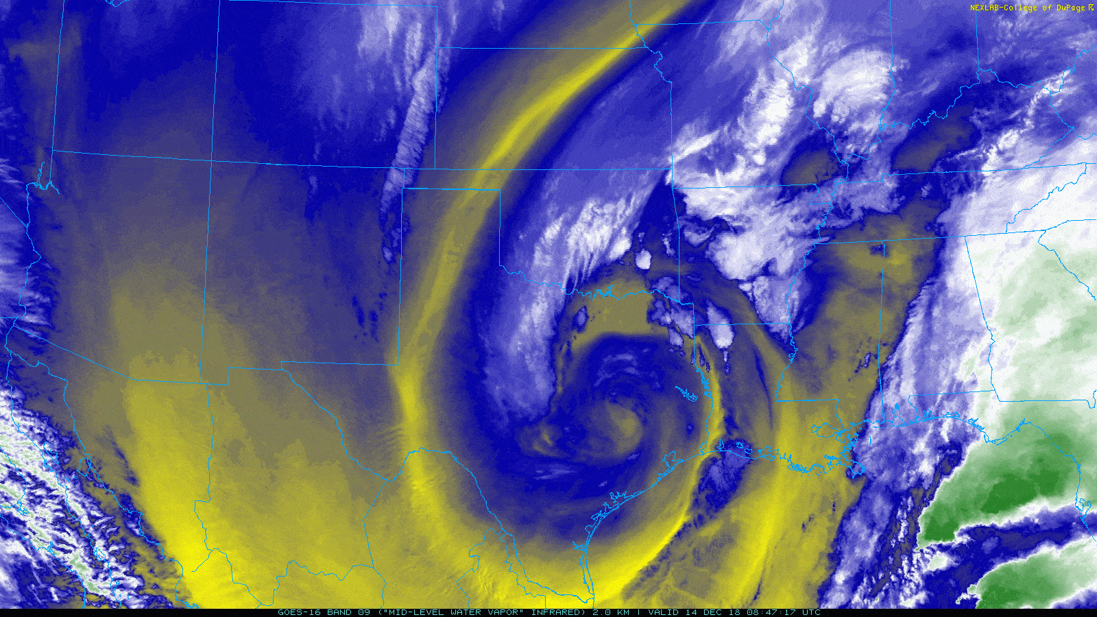
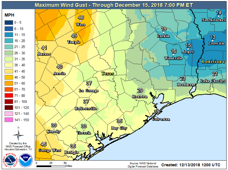
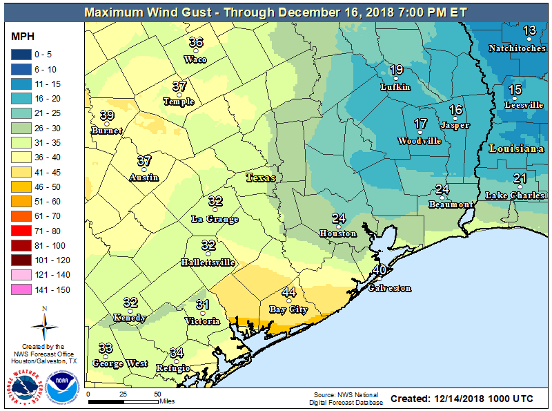
You don’t often see such an interesting picture this far south. What you’re looking at is an upper level low pressure system that is responsible for our winds and some rain showers across the area this morning. Winds have been gusty at times, but for the most part things have been under control. As this upper low shifts to the east, we may see winds pick up again. They almost certainly will in coastal areas.Inland areas will be a bit more fickle.

Wind advisories remain posted for Houston and points south and east today, where maximum wind gusts could approach 35-40 mph. Inland areas probably won’t see winds much worse than have already been experienced. (NWS Houston)

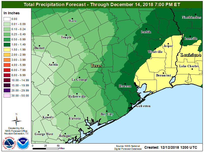
As for rain, we have a few showers up toward Brenham and College Station. The focal point for showers as we shift into the morning and afternoon will be north of I-10 and probably east of I-45. With temperatures in the 40s across most of the area, all precipitation should fall in the form of rain. There could be some wet snowflakes mixed in well off to the north today, out of the Houston area. If there are heavier showers nearby, rain could also mix with ice pellets (sleet). But there would be no accumulation. Showers should diminish toward sunset.

Elsewhere, look for clouds to linger most of today, with gradual clearing holding out until tonight. With the clouds hanging tough, don’t expect a lot of movement in temperatures today. We should manage to get to around 50 degrees this afternoon and that will be all.

Weekend

There will be no weather woes this weekend across Southeast Texas. Look for plenty of sunshine on Saturday after perhaps a few stubborn morning clouds. Temperatures will warm up from the low-40s in the morning to around 60° during the afternoon. Winds will be on the decrease as well, so Saturday is about as perfect a Houston winter day as you could script.

Sunday should be close to equally as nice. Expect mostly sunny skies, though some added high clouds may gradually increase during the afternoon. We’ll be a few degrees warmer on Sunday afternoon. Look for low-to mid-40s in the morning (a handful of spots likely in the upper-30s too), warming up into the mid-60s during the afternoon.

See full post

Breezy front coming, with cooler weather ahead for Houston

As expected, an area of showers moved through the metro area this morning prior to sunrise, dropping 0.5 to 1.5 inch of rain for most of the region. This mass of showers has now pushed east of the area, and as of 6 a.m. the trailing edge was about half way between Houston and Beaumont. A gusty front will follow this afternoon or evening.

Thursday

Some scattered showers will remain possible today until the early afternoon hours, but we’ll see nothing like the organized storms that pushed through earlier this morning. Skies may even become partly sunny this afternoon before westerly winds kick in and a strong front arrives.

This front may produce a very thin line of storms, or a few scattered thunderstorms, as it moves through, but for the most part I think it will probably be dry in terms of rainfall. This westerly flow will push temperatures down this evening, and we can expect a gusty overnight with lows generally in the mid-40s. If you’re heading out this evening, please bring at least a windbreaker.

Maximum wind gusts expected between now and Saturday evening. (National Weather Service)

Friday

This will be a cold, gray, and windy day—with gusts up to about 30mph or perhaps a bit higher along the coast. Highs for most parts of the region will barely reach 50 degrees. Despite mostly cloudy skies Friday night, lows still should drop down to around 40 in most of the city.

See full post

Showers tonight, windy Thursday, stunning this weekend

Conditions are quite a bit warmer across the metro area this morning, with most of the region somewhere in the 50s. Our forecast remains much the same as it’s been—with unsettled weather for a day or so, breezy weather, and then clearing conditions for what should be an excellent December weekend.

Wednesday

Today will be warm-ish for mid-December, with highs in the upper 60s under cloudy skies. Steady, southerly winds will bring the humidity, and also be pushing up moisture levels that will boost rain chances during the overnight hours. Although some light showers are possible Wednesday afternoon and evening, most high-resolution models hold off any stronger storms until later Wednesday night and Thursday morning.

Thursday morning

As an upper-level disturbance moves in from the west, and a cold front barrels down from the northwest, it now appears as though a fairly robust line of showers will move through southeast Texas on Thursday morning, roughly from around 2am through 8am.

Rain accumulations should be greater to the east of Houston. (National Weather Service)

This line of storms doesn’t look too severe—although some thunderstorms are possible—but showers should be heavy enough to drop 1 to 2 inches of rainfall on their way through the area. Fortunately the storms should make fairly steady progress and not linger too long.

See full post

After a frosty morning, and a rainy Thursday, the weekend looks exceptional

Another cold and frosty morning for the region, with a light freeze for areas north of Houston, including Conroe and Huntsville, and mid- to upper-30s in the city itself. We’ll now see a moderate warming trend through Thursday, before another (quite blustery, as it turns out) front pushes into the area. This weekend looks spectacular for December—especially Sunday.

Observed temperatures at 6 a.m. Tuesday. (National Weather Service)

Tuesday

After the chilly start today, we should warm into the lower or even mid-60s under mostly sunny skies. A wind shift to the southeast will aid in the warm-up, and this onshore flow will also keep temperatures tonight a good 10 to 15 degrees warmer than Monday night. Skies turn partly cloudy tonight.

Wednesday

As the onshore flow does its thing, we’ll see a corresponding increase in moisture levels, and our partly cloudy skies will become mostly cloudy. This should limit highs to the upper-60s during the daytime, and we likely won’t see much of a cooldown during the evening hours. Some light showers will be possible later during the afternoon or evening, but probably will hold off until later.

See full post