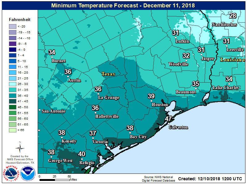
After an oh-so-gray weekend, skies have finally cleared out overnight and this has allowed temperatures to fall to near-freezing north of Houston, into the upper 30s for most of the city, and mid-40s along the coast. With light northwesterly winds out there, it’s quite cold this morning.
Monday
High pressure will dominate our weather today, and although skies will be mostly sunny, temperatures probably won’t rise much out of the mid-50s. Low temperatures on Monday night should be similar to Sunday night, so it will be another one for fireplaces and heaters.
Expect another chilly night on Monday night. (National Weather Service)
Tuesday
This should be another sunny day, and start out a lot like Monday. However, as high pressure moves off, winds will return from the south or southeast later in the day, and this should moderate overnight temperatures. Lows Tuesday night probably will not fall below 50 degrees as the warmer Gulf of Mexico air mass exerts its influence.
Good morning, and I hope we all managed okay overnight. The worst of the rain is long past, though we will still have rain chances for a few more hours this morning. Then, we are just setup for a chilly weekend. Let’s walk through things here.
This morning
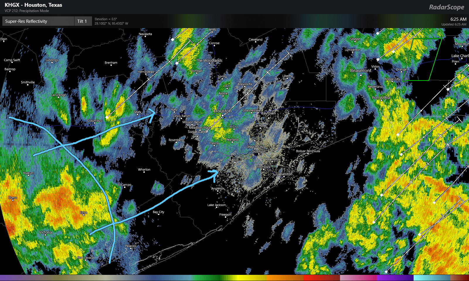
Radar as of 6:20 this morning shows sporadic showers across the region, with heavier rain marching east into Louisiana. We have one additional batch of heavy rain that stretches from near Victoria southwest to Beeville down in South Texas.
Radar as of 6:25 AM showed one final batch of moderate to heavy rain poised to move into the southeastern half of the Houston area this morning. (Radarscope)
This batch of showers will push through the southeast half of the Houston area over the next 2-3 hours. Once that clears, steady rain should end. I can’t rule out lingering light rain or drizzle the rest of today. But the risk for moderate to heavy rain ends with this last batch pushing through.
Travel
As of 6:45 this morning, there were just shy of 20 high water locations on area roadways indicated by Houston TranStar
Houston TranStar maps showed about 20 high water locations, dispersed throughout the area, as indicated by little water droplets on the map here. (Houston TranStar)
The high water locations are pretty evenly dispersed across the region. If you’re out and about early this morning, just keep that in mind and drive carefully. Never go around barricades.
Flooding
Overnight, we saw Keegans Bayou, Halls Bayou, Greens Bayou, Armand Bayou, Little Cypress Creek, and South Mayde Creek come out of their banks. As of 6 AM, several were still out of banks or at bankfull and slowly receding. Cypress Creek, Spring Creek, and Cedar Bayou are all rising but expected to stay within their banks.
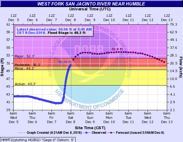
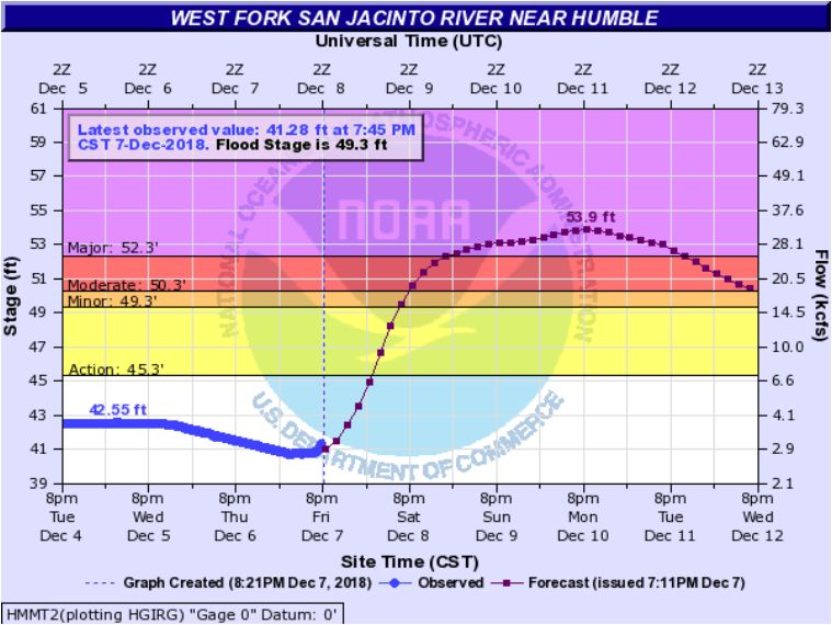
The exception to this will be the West Fork of the San Jacinto River.
The West Fork of the San Jacinto River at Humble is heading into major flood stage and will stay there for a few days. (National Weather Service)
Because of heavy upstream rains and heavy rains in the area, all that runoff is filtering into the San Jacinto River, and it is expected to crest sometime by Monday or Tuesday in major flood stage at Humble. With the forecast of a 53.9 foot crest, major lowland flooding is expected with several subdivisions impacted. You can see the expected impacts at each level on the NWS website for this particular gage. For reference, this particular location crested just shy of 51.7 feet back in March. So this will be a bit higher.
Rain Totals
Houston officially had 4.31″ of rain on Friday, making December 7, 2018 the 5th wettest December day on record in the city, going back to the late 1800s. It was also our wettest single day since August of 2017, which we all know was during Hurricane Harvey.
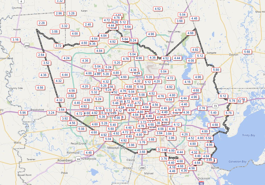
Per the Harris County Flood Control website, most of the Houston area received essentially what was forecast. Most places saw 3-5″ of rain, with a few spots seeing more.
Total rainfall seemed to average around 4-5″ in most of Harris County, with a few spots seeing near or over 6″, and a few others seeing 3-4″ or less. (Harris County Flood Control)
With rain totals like this, it’s never how much falls, it’s how much of it falls quickly that really matters and is always the challenge for us in forecasting. Hopefully we made that clear in the runup to this storm. Fortunately, we’ve now got a few days to dry out, with our next rain chance not in the forecast until at least Wednesday night or Thursday.
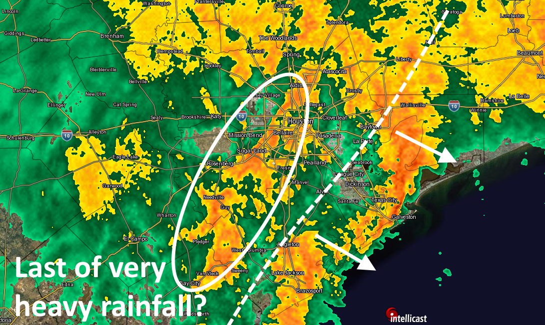
Just a quick midnight update on the state-of-play with Houston’s storms…
A heavy round of showers has now pushed east of the metro region, moving along the coast and toward Beaumont. Behind that, the front (with much lower dewpoints) is pushing into southeast Houston. And behind the front, there’s another area of fairly heavy storms moving east-northeast. We think this is probably the last really burst-y area of storms that will affect Houston tonight. After this, from 2am or 3am onward, we should see some additional light to moderate rainfall, but this too should peter out by around sunrise or shortly thereafter.
Flooding state of play as of midnight Friday. (Intellicast/Space City Weather)
We’re still concerned about the West Fork of the San Jacinto River, which we mentioned earlier, and South Mayde Creek and Langham Creek in Western Harris County are out of their banks and spilling into nearby streets and parks, according to the Harris County Flood Control District. Elsewhere, bayous and creeks are holding.
This is almost over, so hang tight, and lets begin to dry out come sunrise.
Good evening. We’re continuing to monitor conditions across the metro area and rainfall totals remain manageable for most of the region. We have two main concerns: flooding along the West Fork of the San Jacinto River, and the potential for more heavy rainfall later tonight as a main line of at least semi-organized storms moves through. Overall, most of Houston will come through this just fine, we believe.
San Jacinto River
The West Fork of the San Jacinto River, which is downstream of some of the heaviest rainfall today, may potentially go into major flood stage on Saturday or Sunday. According to the Harris County Flood Control District, the following subdivisions may see impacts: Forest Cove, Rivercrest, Northshore, Belleau Woods. Kingwood and Atascocita appear unlikely to be affected at this time.
Potential major flooding along San Jacinto River. (National Weather Service)
Main line of storms
So far today, rainfall amounts for most of the metro area have remained near 2 inches or less (we’ve seen more than this up north, in some parts of Montgomery County and elsewhere). These are quite manageable for area bayous.
As of 8:45pm CT we are seeing storms get organized just west and north of Houston, and from now until about 3am CT we are likely to see the potential for additional heavy rainfall as this mass of storms moves through, from west to east along with the front. Conditions will likely deteriorate for much of Houston over the next hour or two, so now is the time to be wrapping up any activities and getting home.
Most areas may see an additional 1 to 3 inches of rainfall from now through 3am—which should be fine for most bayous—although a few areas may see a bit more than this. After 3am we should see a slackening in rainfall on the west side of the metro area, and then a gradual ending beginning shortly before sunrise from west to east.
Saturday will be gray, and chilly, with highs in the 50s and blustery northerly winds.