Rains so far today have stayed mostly to the north and west of the Houston metro area, as anticipated. As of 2pm CT, just south of Huntsville is the big “winner” with about 4 inches of rain falling so far. Not a whole lot has changed with our forecast, but I did want to call out a few things we’re watching as we get closer to heavier rainfall this evening and during the overnight hours.
Models not showing extreme totals: None of the high-resolution models are really bombing out huge rain totals with this event. So while some forecasts have been calling for up to 10 inches of rainfall during the next 12 to 24 hours. We’re feeling more comfortable with 7 or 8 inches as an upper limit, with most of the area seeing 2 to 5 inches of rainfall.
Heavier rains more likely north: Some of the models suggest the heavier rain totals (5 inches or more) will generally fall north of Harris County, with most of the metro area remaining under that threshold. Other models show the rainfall pretty well dispersed, so we’re not overly confident with this part of the forecast.
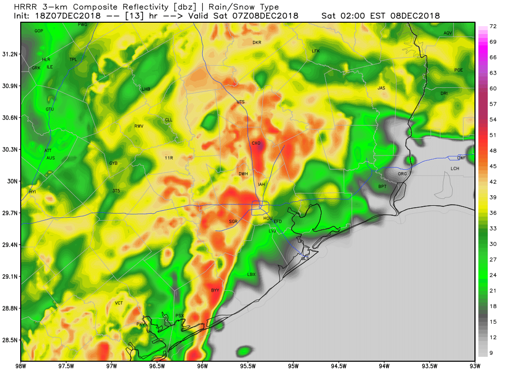
Line of storms timing: The point at which the front (and a line of strong thunderstorms) moves through Houston has moved up somewhat, and now appears likely to sweep through the region, from west to east, between around midnight and 3am. This is the time when you definitely won’t want to be out and about due to the potential for heavy rainfall, flooded streets, and strong thunderstorms.
HRRR model forecast for line of storms as of 1am CT Saturday. (Weather Bell)
Flooding potential: Because some of the heaviest rainfall will occur well inland, we’ll have to watch for potential flooding along the Trinity, San Jacinto, Brazos, Navasota, San Bernard, and Colorado river basins. In terms of bayous, Jeff Lindner of Harris County said he’s most concerned about bayous and creeks across the northern, northwestern, and northeastern parts of the county: Cypress, Willow, Little Cypress, Cedar, West and East Forks of the San Jacinto, South Mayde, Langham, Bear. We think most of these will probably remain within their banks.
Event will end: We are not overly concerned about Friday night’s event, because it’s going to come to a pretty abrupt end by or before sunrise on Saturday. This will be kind of a nasty rain event for December, but if this were July or August, it wouldn’t be considered all that extreme. Our bottom line is that, if you’re overly anxious about this event, it’s probably not going to be as bad as you think.
We’ll be back this evening with an updated forecast.
Good morning. Let’s get right into the forecast here, as a significant winter rainstorm begins to bear down on Southeast Texas.
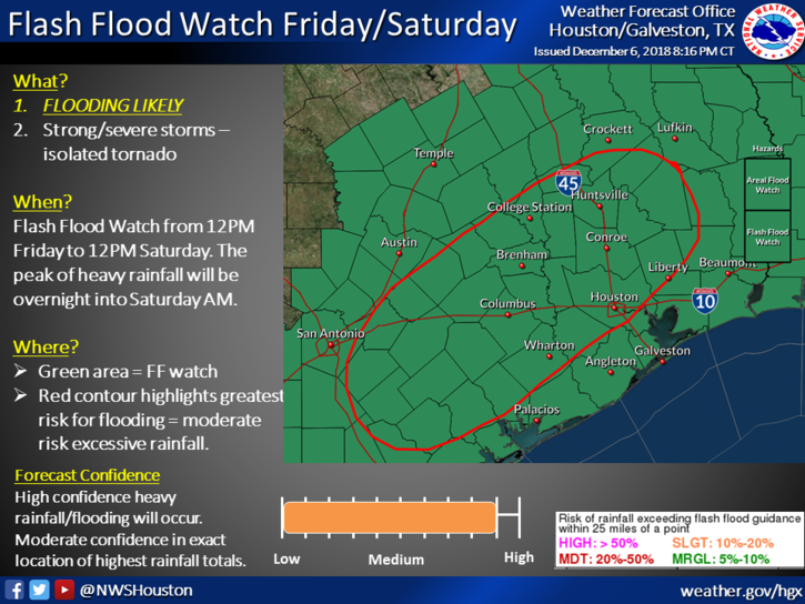
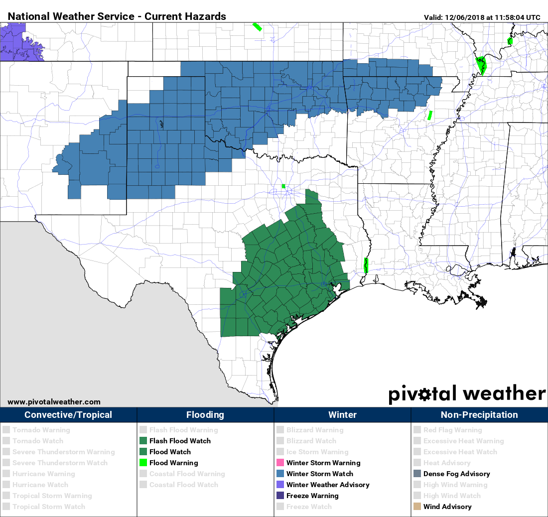
First off, Flash Flood Watches will go into effect for the entire region today and tonight.
The National Weather Service will hoist a Flash Flood Watch across the entire region at Noon today. (NWS Houston)
This means conditions will be favorable for flash flooding, street flooding, and some substantial rises in area creeks, rivers, and bayous. If you’ll be out and about tonight, you will want to have a way to receive updated weather information. Space City Weather will be updated through the night as well, but make sure you have a couple sources of the latest information and a way to see radar.
Also, something that’s occasionally underappreciated: If possible, please make sure your neighborhood storm drains are free of leaves and debris. We are “past peak” fall foliage in Houston now, and many leaves have found their way to storm drains and gutters.
Clearing these areas allows water to drain more effectively and will often mitigate some street flooding issues.
This morning
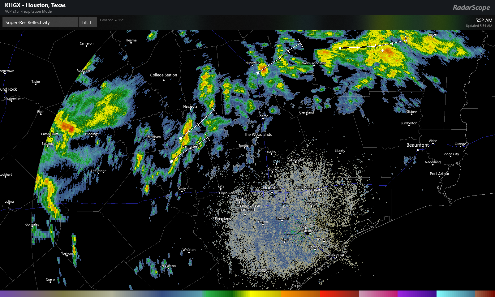
Radar this morning is quiet in Houston, but scattered showers have developed northwest of the city.
Radar as of just before 6 AM Friday shows some isolated to scattered storms and showers northwest of the Houston Metro. This will gradually slump south and east this morning. (RadarScope)
Expect scattered showers and the possibility of some thunder to continue through the morning hours north and west of Houston. This area should advance closer to Houston as well, bringing some rain chance to the city by late morning.
This afternoon
Expect showers and thunderstorms to become more numerous and widespread as we go through the afternoon, especially along and northwest of US-59. We will want to watch this to see if rain can advance farther southeast than expected, as this could push the steadier rains more into the central part of the Houston metro, rather than it being skewed northwest. Regardless, I don’t anticipate that we’re going to see a lot of flooding issues around the region through afternoon. That risk ramps up tonight (read more below).
But still, I would expect that we could see on the order of a half inch to two inches of rain on average during the daytime today from the city of Houston to the north and west, with lesser amounts south and east. However, we will need to watch southern and eastern areas later this afternoon for some isolated potentially strong to severe storms.
This evening
Steady rain could taper to scattered showers in spots, but in general, expect occasional showers, downpours, and thunderstorms through midnight, with the greatest concentration from the city of Houston to the northwest.
The HRRR model radar forecast for 9 PM tonight shows scattered to numerous downpours and thunderstorms across the area, especially along and north/west of US-59. Use caution if out and about tonight. (Weather Bell)
The image above is a forecast radar for 9 PM this evening. You get a sense of the patchy nature of things. Not everyone will be in downpours constantly, but some areas will get hit more often than others. If you get into a lull in the rain, just be advised that the event isn’t over and heavier rain will be incoming overnight from the west.
Overnight
This will be the main event. A strong, slow moving line of thunderstorms will plow across the entire region around or after midnight. This band of storms will be capable of producing 1-3″ of additional rain, or more, in short order as it moves west to east across the area. After today’s rains, grounds will be saturated, and runoff will be quicker than usual. This will be the band of rain most capable of producing widespread street flooding and leading to rises on bayous in the area. The areas most vulnerable to flooding will be those that see the most rain during the day today and in the early evening. Our assumption is that we’ll see this occur along and northwest of US-59. But we will obviously know more this afternoon as this event begins to setup.
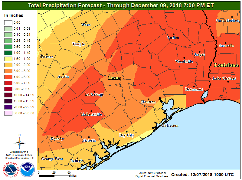
Rain totals of 2-5″ on average are expected across the region between today and tonight. There is a chance areas southeast of Houston will see less rain, and a chance that a few places from Houston north and west could see as much as 5-10″ of rainfall. (NWS Houston)
Once all is said and done, we expect two to five inches of rainfall across the area, with a few locations perhaps seeing as much as five to ten inches of rain. That will not be the case in most of the area, but there will be dollops of some of those bigger ticket totals in parts of the region. As noted, where those occur will determine who exactly is at highest risk of flooding. Obviously, use extreme caution if you’ll be travelling tonight and never drive through flooded roadways, especially at night, when it’s extremely difficult to judge how deep that water is that’s covering the road. Eric will have an update on how things are progressing later today.
The sunny weather we’ve enjoyed this week is now gone, as high pressure has been firmly supplanted by an onshore flow. We’ll see a steady diet of cloud cover through Saturday, with moisture moving onshore that will culminate in the potential for heavy rain on Friday night and Saturday morning. To mark this threat, the National Weather Service has issued a Flash Flood Watch for the region from Friday afternoon through Saturday morning. We discuss this threat below.
Green area denotes extent of National Weather Service Flash Flood Watch for Friday and Saturday. (Pivotal Weather)
Thursday
After a start in the 50s, highs today will climb into the upper 60s under mostly cloudy skies. Southeasterly winds will transport moisture inland throughout the day, and although we can’t rule out a few isolated showers we don’t expect anything significant. Low temperatures Thursday night won’t fall much below the mid-60s for most of the area.
Friday
The upper-level low pressure system will be moving down through Texas, approaching the Houston region from the north-northwest. We expect some light- to moderate rainfall on Friday in the Houston metro area during the daytime, but for the most part, heavier showers should remain west of Harris County until around sunset or so. Highs Friday should climb to near 70 degrees under mostly cloudy skies.
We’re continuing to track the potential for heavy rainfall on Friday, Friday night, and Saturday morning as a strong front moves through the region. Unfortunately, the models remain highly consistent in forecasting a wet night, with the potential for widespread totals of 2 to 5 inches of rainfall, and some bullseyes of up to 6 to 8 inches. The atmosphere won’t be too favorable toward severe weather, so the primary threat is heavy rainfall and the potential for some light to moderate flooding.
As a reminder, if you want the latest updates from this web site you have several options:
You can sign up via e-mail (find the “Subscribe via e-mail” box on the right of the site on the desktop version, at the bottom on mobile)
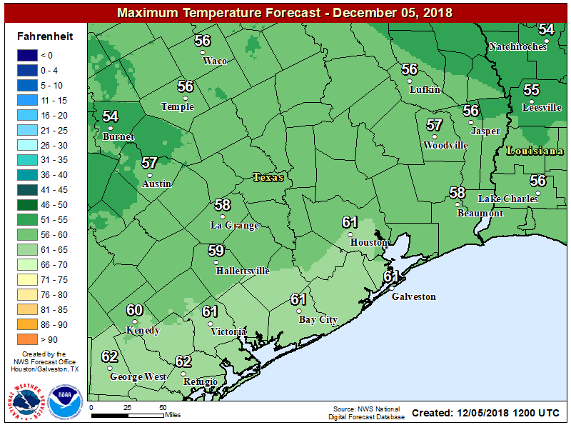
Conditions today will be a lot like those on Tuesday, which is to say a cold start, followed by a sunny warm up into the low 60s. However, a subtle wind shift from the northeast to the east later today will allow for a few clouds to develop later tonight, and should moderate low temperatures to around 50 degrees in Houston—colder up north, a bit warmer along the coast.
High temperatures on Wednesday. (National Weather Service)
Thursday
Winds will shift to come from the southeast on Thursday, and this will represent the return of a moist, onshore flow from the Gulf of Mexico. This will help ramp up moisture levels ahead of the front, but it won’t manifest in rainfall immediately. Instead, Thursday will be a mostly cloudy affair, with highs in the mid- to upper-60s, and those southeasterly winds.