Another day of scattered to widespread storms for Houston

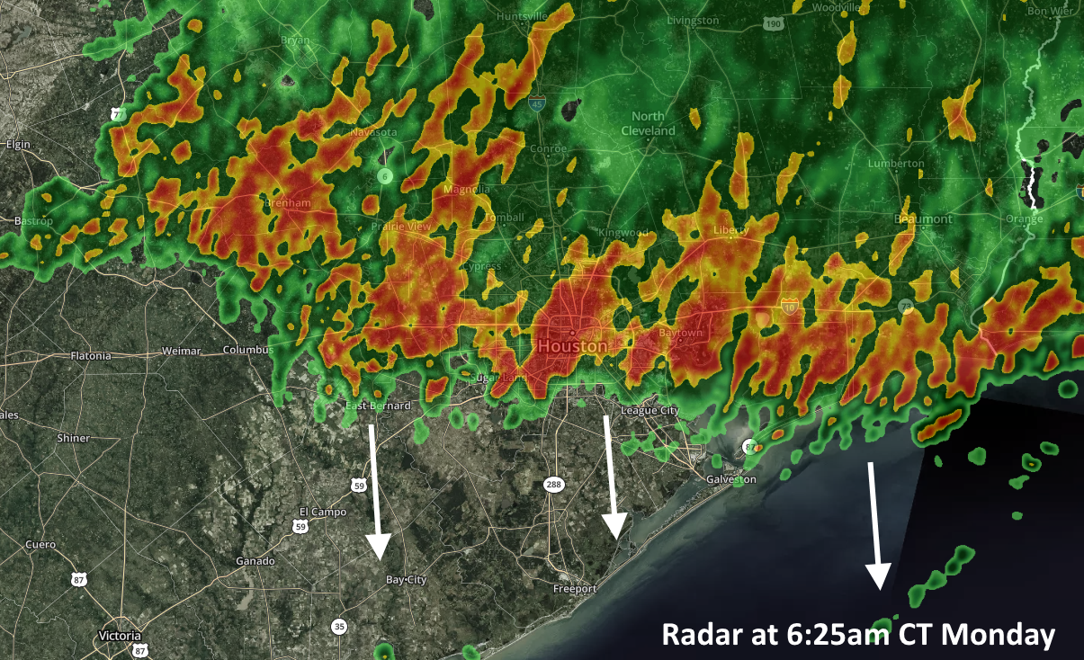
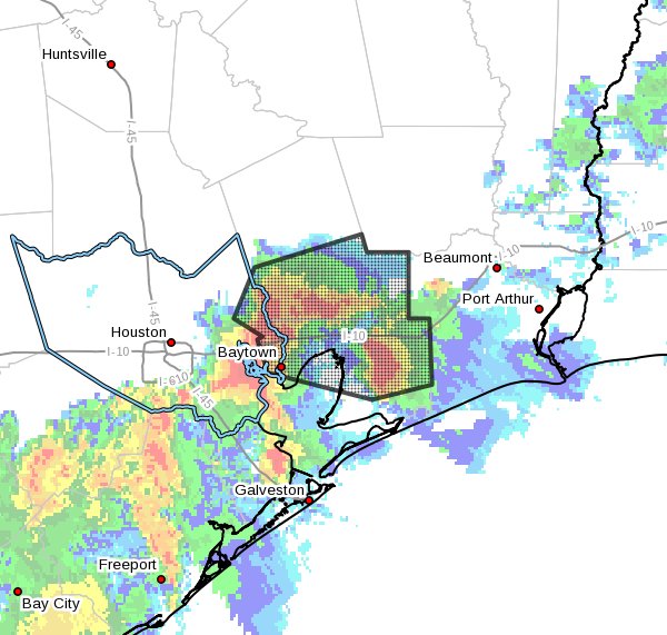
Storms are firing again this morning, primarily to the south and east of Interstate 69, where a few areas have already picked up 1.5 inch of rainfall. We’re going to remain in a pattern where there is the potential for storms through the next 12 to 24 hours before higher pressure returns to the area until the weekend.

An areal flood advisory is in effect for the hashed area through 9:15am. (National Weather Service)

Tuesday

Overall, our atmosphere should remain moist for pretty much all of today, with precipitable water values of 2 inches or greater, meaning it won’t take too much of a spark to generate showers and thunderstorms. This pattern will allow for the development of on-and-off showers, moving generally to the east-northeast. Unfortunately, storm movement will be fairly slow, which will allow for some areas to see totals of 1 to 3 inches, and some street flooding. Although the rain has developed near the coast this morning, various models show the potential for development at most any location later today. Clouds and intermittent showers should help keep highs in the upper 80s for most of the region.

Wednesday

Pressures begin to build, and this should help to limit storm activity. However, with a still-moist atmosphere, I think at least about 30 percent of Houston should see at least some brief showers. Highs will get into the low- to mid-90s, as some sunshine returns.

See full post

Houston storms ending Monday morning, more rain possible Tuesday

A broken line of showers and thunderstorms is pushing through Houston on Monday morning. These storms have been a little more frisky than anticipated north of the city, dropping 1 to 3 inches of rain, but they appear to be weakening as they move through central parts of the metro area toward the coast. These storms should move through Houston by mid-morning and then off the coast by or before noon. The primary threats are wind gusts above 30mph and brief, heavy rainfall. The primary benefit is cooler air thanks to a “cold pool” in the atmosphere that is helping to drive this morning’s storms. Alas, it won’t last.

Houston radar at 6:25am CT. (kktv/com)

Monday

After this area of relatively unstable air moves away from Houston later this morning, rain chances should fall significantly—leaving the region with only isolated, to scattered showers for the rest of the day. Winds will remain blowy, with gusts up to about 20mph. Partly to mostly cloudy skies should help moderate temperatures for the remainder of the day, limiting them to perhaps 90 degrees or even the upper 80s. Low temperatures on Monday night may get into the upper 70s for inland areas, but we won’t see too much cooling.

Tuesday

This has the potential for another wet day, as an upper-level disturbance moves through the atmosphere from west to east. This will provide a healthy chance of showers, probably about 50 percent, later in the day. Forecast models are hinting at the potential for another 1-2 inches of rain from this system for parts of Houston that get hit—and probably little to no rain for those that don’t. This is because storms that develop on Tuesday may be fairly slow moving. Highs will be in the low 90s.

See full post

The longest day of the year in Houston will have summer-like heat to match

Congratulations, Houston. We’ve reached the longest day of the year—14 hours, 3 minutes, and 30 seconds. From this point on, days will very slowly get shorter as the Northern Hemisphere begins to tilt away from the Sun. In six months, our day length will be just 10 hours, 14 minutes, and 3 seconds.

Houston has just 6 hours, 44 minutes of true night at this time of year. (timeanddate.com)

Of course Houston doesn’t reach the peak of summer for another five weeks, with the warmest period typically coming from late July through the first half of August. This is due in large part to weather patterns, and a lag in heating of the Gulf of Mexico, which always modifies our region’s weather when the winds are blowing onshore (cooling us during this time of year, and warming us in the winter). Bottom line? We’ve begun the march toward fall, but it’s still a long, long ways away.

Lots of heat in West Texas on Friday. (Pivotal Weather)

Friday

Speaking of summer, we’ll feel it today, with highs in the mid-90s and high humidity pushing the heat index into “heat advisory” levels out there. With partly sunny skies, please avoid being outdoors during the middle of the day if possible. Temperatures tonight will not cool much, only falling to around 80 degrees.

See full post

Heat advisory in effect due to high humidity, temps in upper 90s

Good morning. Northern parts of the metro area may be clipped by fast-moving thunderstorms this morning—Conroe and areas north—but by far the biggest story of the day will be heat. The National Weather Service has issued a “heat advisory,” indicating that the heat index will reach 106 to 111 degrees. This essentially means that the temperature in the shade, when factoring in humidity, will feel much warmer than the actual temperature in the mid- to upper-90s. If you’re in the sunshine, the effect will be even more pronounced.

Heat advisory for Thursday with “heat index” temperatures. (National Weather Service)

Thursday

Aside from the heat, and partly sunny skies on Thursday, southerly winds may gust up to 20 mph across the area, reflecting higher pressures to the south and lower pressures over the continental United States. These winds are not reflected in the heat advisory temperature above, but may provide some limited cooling despite the high humidity today. All in all, however, it will be a hot summer day in Houston, with highs ranging from the mid- to upper-90s. The other notable factor will be nighttime temperatures that likely don’t fall below 80 degrees on Thursday night or the next few nights.

Friday

This will be another warm and windy day, although highs probably will top out in the lower to mid-90s. Skies will be partly sunny.

See full post