Well, so much for the high pressure that was supposed to tamp down on rain activity Thursday. Despite the influence of a ridge to the west of the region, some pretty strong showers still popped up over Houston, dropping as much as 1.5 inches near the Waller-Harris County line Thursday. I think we’ll be in for a similar pattern this weekend in which perhaps only 30 to 40 percent of the Houston area receives rainfall in any given day, but those areas that do see showers could experience some briefly heavy rainfall. Welcome to the game of rainfall roulette.
Friday
Mostly sunny skies this morning should allow temperatures to push up into the low- or even mid-90s by early this afternoon, and this will be warm enough to help generate some scattered showers and thunderstorms.
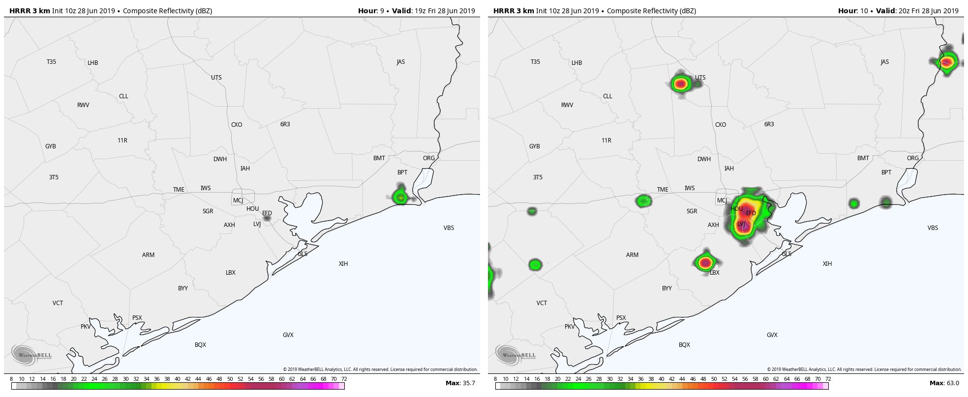
HRRR model radar forecast for 2pm (left) and 3pm (right) show the potential for storms to pop up quickly Friday afternoon. (Weather Bell)
High resolution modeling suggests these storms will initiate around 2pm or 3pm and then wane by or before sunset with the loss of this daytime heating. Rainfall could be briefly heavy under some of these storms, potentially making something of a mess during the evening commute. However, we don’t have any flooding concerns beyond the usual mess on streets. Lows Friday night should fall into the mid-70s.
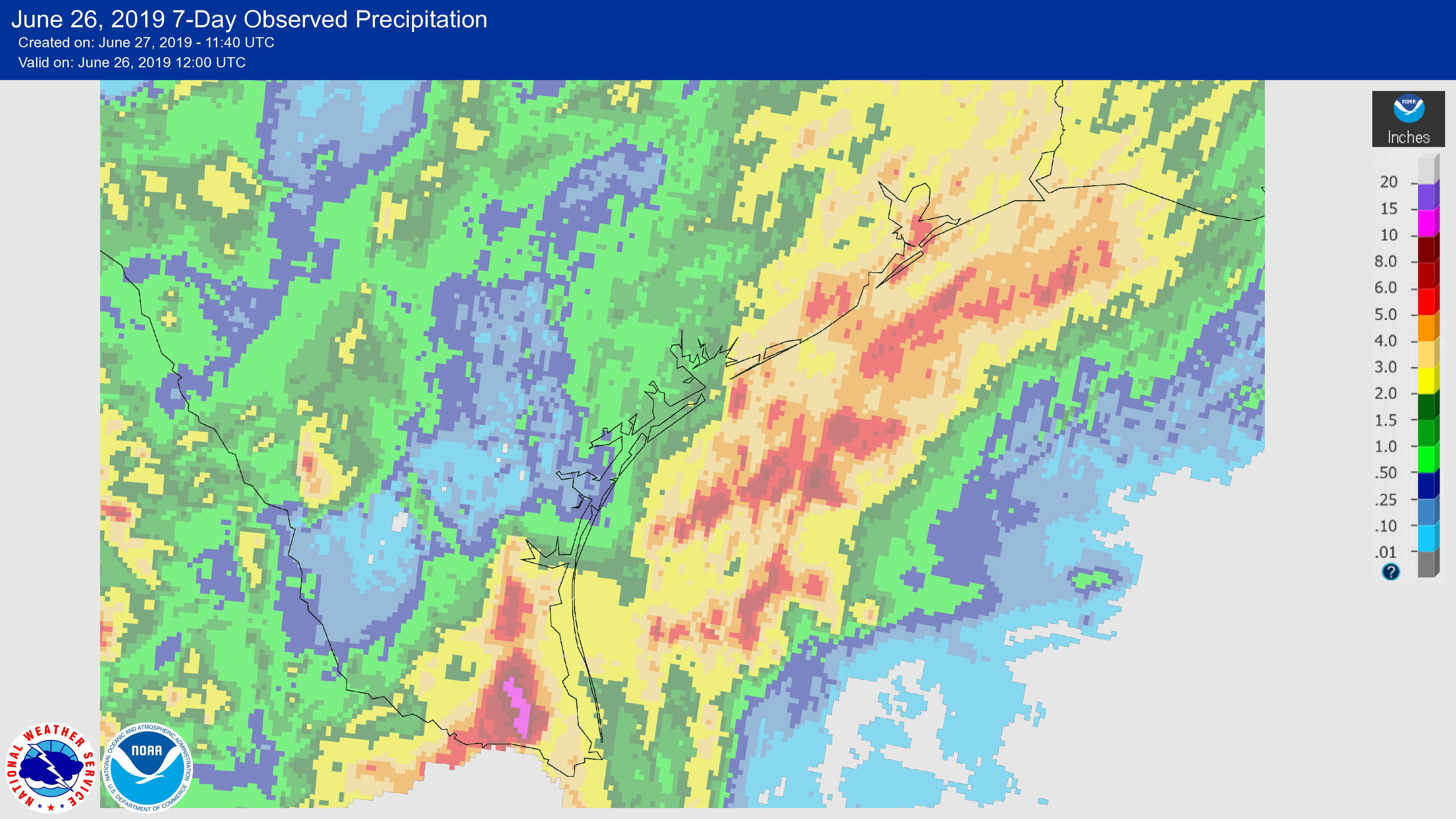
It has been a wet week for much of coastal Texas, with the combination of moist air moving inland, and the absence of high pressure to keep rainfall at bay. The Valley was hit especially hard, with areas near Harlingen and McAllen receiving in excess of 10 inches and experiencing some pretty significant flooding. Closer to home, parts of the coastal Houston region saw 3 to 5 inches of rainfall. We’ll now mostly dry out for a few days before the potential for some heavier rain returns early next week.
Seven-day rainfall totals. (NOAA)
Thursday
Today should see the return of mostly sunny skies to Houston, although we can’t entirely rule out the possibility of a few isolated, pop-up storms. But for the most part, we’re just going to see a warm, June summer day with highs in the low 90s and moderate southerly winds. Overnight temperatures may lower into the mid-70s—if you’re lucky, and live far enough away from the coast.
Friday
This should be a similar day to Thursday, although we’ll probably see rain chances on the order of 10 to 20 percent, again in the form of some pop-up showers. Otherwise, expect mostly sunny skies with highs in the low- to mid-90s.
If you missed it, Eric and I have decided to start doing tropical updates for you every week or two through hurricane season. We had our first one last week, which was rather detailed. This week, we’ll be a little more succinct!
Tropical outlook in a sentence
The Atlantic basin continues to be void of much interesting tropical activity, and it will likely continue that way for the next week to 10 days.
Near-term summary
Dust, dust, dust. And shear. Those two things are characterizing the Atlantic basin today. Dust from the Sahara Desert continues to roar across the Atlantic. This tends to be a fairly common feature in the early parts of hurricane season. We’ve noticed it a lot more in recent years, and I’m not sure if that’s because of some functional change or just because our observational capabilities have gotten so much more sophisticated. Either way, the last few years have seen a lot of Saharan dust in the basin in June and July.
Widespread Saharan dust is spread out across virtually the entire Atlantic basin right now, which should help limit tropical activity for a little while longer. (University of Wisconsin/NOAA)
From the satellite image above, you can see where dust (yellow/orange/red) is located, as well as cloud cover (gray). Virtually the entire Atlantic basin is littered with Saharan dust right now. This includes the Gulf of Mexico. Some of that thicker dust is likely to appear in Houston’s skies in the days ahead.
Why does this matter? Well, Saharan dust is extremely important globally. It’s a major source of nutrients for phytoplankton, and it helps to fertilize the Amazon. It obviously doesn’t come without problems, as the dust can irritate those who have sensitive respiratory systems, allergies, or asthma. It reduces air quality, and we may well see that here in Houston for late this week.
But from a tropical point of view, Saharan dust can help hinder systems from developing. The dust is indicative of dry air in the atmosphere. Obviously, hurricanes need moist air. Think about our weather here in Houston. On days with a “cap” in the atmosphere, there’s a barrier that exists preventing or limiting how high cloud tops can go. That reduces our thunderstorm chances. The Saharan air layer can act as a “cap” as well, preventing storms from billowing up. It doesn’t entirely prevent tropical storms or hurricanes from developing, but it can severely limit how well developed they can become. So curse the dust when it irritates your sinuses, but thank it for helping to keep the early part of tropical season under wraps.
Good morning. The radar is a bit quieter this morning, so before jumping into the forecast I wanted to note a dubious record the city set last weekend. According to World Climate Service on Twitter, Saturday was the most humid day on record at Houston’s Bush airport (which has recorded hourly data since 1969), with an average hourly dewpoint of 79.7 degrees Fahrenheit. The four days from June 20 through June 23, in fact, ranked as four of the top six spots for daily mean dewpoint in Houston. As a reminder, here’s how Matt recently characterized dewpoints, and how they feel:
70s means uncomfortable, or typical summer
60s means humid, but not terrible
50s means mostly comfortable
40s or less means very comfortable or dry
Now, on to the forecast.
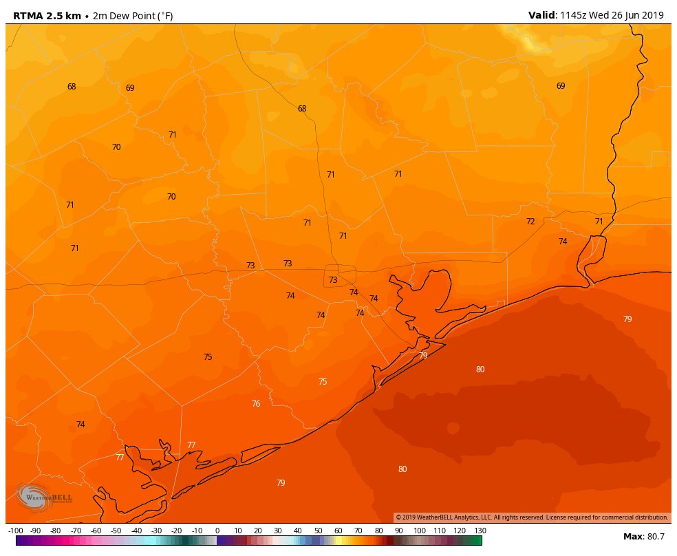
Dewpoint temperatures are more manageable on Wednesday morning. (Weather Bell)
Wednesday
In case you were wondering, dewpoints this morning are generally in the low 70s. We’re going to see another day with scattered, daytime showers across Houston. Accumulations should be less than Tuesday, but we can’t rule out some areas seeing a 1 inch or so of rainfall, with a higher bullseye under the slowest-moving storms. Most of the area will probably see 0.25 inch or less. Highs will get up to around 90 degrees, although local temperatures will depend upon the extent of sunshine your area receives. High pressure should begin to build in this evening, shutting down rain chances area-wide.