Heavy rain is coming to Houston, but the details are messy

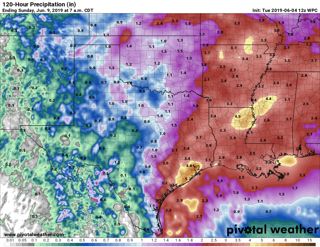
I want to preface this post by saying that this is a low-confidence forecast, overall. What we can say with some confidence is that heavy rains are moving toward Houston, and in some cases already moving inland between Freeport and Galveston. This will set the stage for a wet period in Houston from Tuesday evening through Thursday morning. A flash flood watch is in effect, and we are predicting a Stage 2 flood threat for the area. What we are not so confident about are the details—such as where will the heaviest rainfall occur, and will the big bullseyes of rainfall be 6 inches, 10 inches, or more? Let’s take it day by day.

Radar at 3:20pm CT on Tuesday (kktv.com)

Tuesday evening through Wednesday afternoon

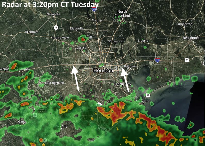
We anticipate that this initial round of showers moving into the coast this evening probably will reach about to Interstate 10 before winding down, probably by or before midnight. After this, models are indicating that a more organized band of storm activity will move into the coast between midnight and sunrise Wednesday. This could occur anywhere between Matagorda Bay and Galveston Island, although at this point I’d probably lean toward the southwest, and Matagorda/Brazoria county area. These storms may very well be efficient rain producers, with rainfall rates of 2-, 3- or more inches per hour, which will quickly back up streets.

See full post

Tropical disturbance may bring heavy rainfall tonight through Thursday

It now appears less likely that a tropical blob in the southern Gulf of Mexico will develop into a tropical depression, but for our purposes that doesn’t really matter—a large amount of moisture is headed up the Texas coast and this will bring heavy rainfall to parts of the area beginning as early as tonight through Thursday morning. High tides of 2 to 3 feet above normal are a secondary concern for coastal areas, but the biggest threat from this system is high hourly rainfall rates.

NOAA total rainfall forecast for now through Saturday. (Pivotal Weather)

As with most tropical events in the region, this one is difficult to forecast. With such a moist atmosphere, there is the potential for a lot of rain, but with this system the heaviest rains could remain offshore. In issuing a flash flood watch for Houston, the National Weather Service is predicting widespread totals of 2 to 4 inches, with isolated areas seeing 6 inches or more (most likely somewhere near Galveston Bay). This seems about right. Due to the potential for high hourly rainfall rates, which can quickly flood streets, we are predicting this will be a Stage 2 flood event on the Space City Weather flood scale for Houston. This essentially means that while we anticipate the potential for significant street flooding—turn around, don’t drown—we do not think there will be much structure flooding.

In terms of timing, there are some regional models that show heavy storms moving into Houston as early as 9 or 10pm tonight, but others delay the heavier rain until after sunrise on Wednesday. Basically, I think the simplest, most accurate forecast is to say the potential for heavy rainfall will begin after sunset on Tuesday night, and last through Thursday morning.

If there’s good news, it’s that the upper-level pattern supports pulling this very moist air mass away from the area on Thursday afternoon or evening, and replacing it with drier air—so this wet pattern is unlikely to linger. We’ll stay on top of this through the entire event.

See full post

Tropical disturbance brings high rain chances to Houston this week

Houston’s hot weather—the region got its first real taste of the mid-90s this weekend—will continue for one more day before moisture begins streaming into the area from the south. From late Tuesday through Thursday, a tropical disturbance moving up the coast will bring a healthy chance of rain to the region. While some heavy rain is likely, we don’t have any major flood concerns at this time. The National Hurricane Center gives the system a 60 percent chance of becoming a tropical depression or storm, and the ceiling on intensity is almost certainly a low-end tropical storm. More on this below.

Tropical disturbance status as of 6:30am Monday. (National Hurricane Center)

Monday

Conditions today will be a lot like Sunday, with partly to mostly sunny skies, and high temperatures in the low to mid-90s. Sunscreen, water, and repeat. Lows Monday night will only fall into the upper-70s.

Tuesday

Skies will turn partly cloudy as moisture begins to move into the area from the south. Rain chances should remain fairly low—20 to 30 percent —for most of the day before the tropical tropical disturbance begins pulling north toward the region. Timing is a bit tricky, but the heavier rain should hold off through the daytime hours on Tuesday. Highs will be around 90 degrees during the daytime.

See full post

Hurricane season begins, and yes, something may develop in the Gulf

June 1 marks the “official” beginning of the Atlantic hurricane season, and although it often begins quietly, we start this season with an eye on the Gulf of Mexico. For a couple of days now, the European model ensembles have been hinting at the formation of a tropical system in the southern Gulf of Mexico, and now this appears more likely. On Saturday morning, the National Hurricane Center raised to 50 percent the possibility of a tropical depression or storm forming there during the next five days.

As of 7am CT on Saturday, the National Hurricane Center forecasts a 50 percent chance of development.

All the usual caveats apply here: It is difficult to have much confidence in the movement of a system that has not yet formed, and it will also be affected by its proximity to the Mexican coast. With that said, generally, we expect this tropical system to move to the west-northwest over the next few days, perhaps toward Tampico (along the country’s east coast on the southern Gulf of Mexico) or Brownsville.

Assessing where this tropical system may go. (Tropical Tidbits/Space City Weather)

What this all means for Texas in general, and Houston in particular, for the coming week is far from certain. We still expect partly to mostly sunny skies through at least Monday, with hot temperatures in the mid-90s. But our weather beyond this, to some extent, will be determined by the movement of this tropical system. The ceiling for this system, in terms of winds, is low, so our primary concern will be the potential for moderate to heavy rainfall.

Eventually, it is going to get pulled north, so we can have some confidence in wet weather for Texas next week, but confidence for where, and how much rain, remains low. I’d say the best chance for heavy rainfall in Houston would come from late Wednesday through Thursday, but there are so many variables we’ll just have to see. For now, we’re not too concerned about the potential for any flooding in the greater Houston area—forced to guess, I’d say 1-3 inches of rain—but obviously we’ll be monitoring this for you.