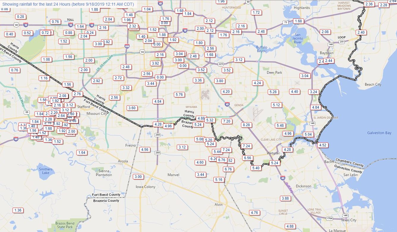
For much of the Houston area, the first day of widespread rainfall from the tropical storm formerly known as Imelda has been mostly a non-issue. Large swaths of the metro area north of Interstate 10 have received less than one-half an inch of rainfall. Count yourselves lucky. Parts of southern Brazoria County, as well as the Alvin, Clear Lake, Pearland, and Friendswood areas have received 6 to 8 inches of rainfall over the last 24 hours. Soils south of Houston are sodden, and some stretches of Clear Creek are nearing their bankfulls.
24-hour rainfall totals for Tuesday. (HCOEM)
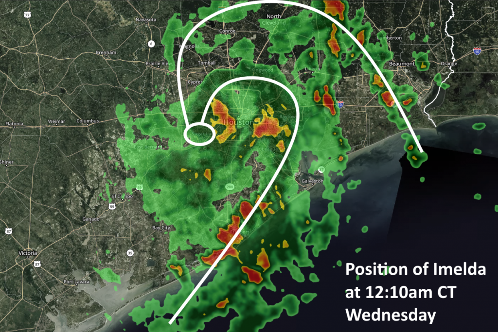
As of shortly after midnight, Imelda’s “center” appears to have moved almost directly over Sugar Land as it slowly wobbles northward across the Houston metro area. This “drunken sailor” motion will probably continue for the next day or so as the system slowly lifts northward. Looking at the radar at this time, there are several clusters of fairly heavy showers and thunderstorms, particularly right along the coast, moving from Brazoria County toward Galveston County.
Imelda’s position as of 12:10am CT Wednesday. (kktv.com/Space City Weather)
But fortunately we have yet to see the really intense rainfall rates of 2.5 to 5 inches per hour that can quickly back up bayous, roads, and flood yards. For the rest of the night, some of the high resolution models are continuing to show rain showers really blowing up between midnight and mid-morning Wednesday, but so far we’re not seeing that really verify on radar. However, the scencario remains plausible given the highly efficient moisture transfer by Imelda from the Gulf inland, along with plenty of atmospheric instability. The biggest area for concern is probably south and east of Interstate 69 for the rest of the night.
As for Wednesday and Thursday, both days will have the potential for heavy rainfall. Hard to say which has the higher potential, but for now I’d probably go with Wednesday as the system should really begin to pull away from Houston on Thursday.
Tropical Storm Imelda has begun its transformation into a significant “blob” of rain over Southeast Texas this evening. Let us walk you through what we are expecting through Wednesday morning.
Now
Imelda is now classified as a tropical depression, and if I’m reading the radar correctly, the center as of 7:45 PM was located just west of Pearland and becoming more diffuse.
Tropical Depression Imelda is spinning away and crawling north this evening across Brazoria County. (RadarScope)
You can see from the radar loop above that Imelda has 2 or 3 areas of main concern, as it relates to rainfall. There is the main “core” of the storm over Brazoria County. This will be the primary rain producer this evening. As the center crawls north, that will come with it. This is what we are concerned about for the bulk of the Houston Metro.
The second area is a feeder band to the east of Baytown. That is aimed at parts of Galveston Island and north toward Chambers and Liberty Counties. That is not expected to move much, and within this region, expect heavy rain and potentially localized flooding overnight.
The third area is a band well to our east, aimed at the Beaumont/Port Arthur area or just west. That will be capable of some heavy rainfall tonight as well. But it may weaken a bit as this band near Baytown takes over.
So a lot happening here.
Overnight
I mentioned above that Imelda’s center is becoming more diffuse. That means that more erratic behavior of the storm track could occur. So expect that heavy rain currently located over Brazoria, Galveston, and southeast Harris Counties to lift north into the bulk of the Houston metro area. At nighttime, tropical systems can sometimes see rains intensify a bit. So I fully expect heavy rain at times in Houston and points south and east. At a minimum we would expect 2 to 5 inches of additional rain in these areas by sunrise on Wednesday. We could see some spots pick up as much as 5 to 8 inches or even more, however, and those would be the areas we’re most concerned with in terms of flooding. Again, that would be most likely from Downtown Houston south and east.
For those north and west of Downtown Houston, we expect periods of rain overnight, locally heavy. While we will monitor those areas for flooding risks, we do not think it is quite as serious as south and east. But given that there is still a degree of uncertainty with this system, the entire region should monitor the progress of the rain, both before bed and when you wake up. Do not assume tomorrow that you’ll be able to get to the airport or to work without issues, so make sure to check in on what has transpired overnight in the morning.
Wednesday daytime
We should see rains continue off and on through the day Wednesday. We could see a bit of a lull in the activity for a time during the afternoon hours before heavy rain sets back up late. Again, we have some uncertainty around exactly how tomorrow will unfold. Eric will have an update later this evening, and I will update you more on Wednesday’s outlook in the morning.
Wednesday evening and beyond
We expect another round of heavy rain tomorrow night, again in multiple areas. We’ll likely see the “core” of the storm reignite tomorrow night with heavy rain gradually lifting north of Houston. We aren’t entirely sure if that will be aligned over the center of the city or more to the east. We also will likely see another significant “feeder” type band east of Houston, though we’re not quite certain where that will be aimed. Check with us tomorrow for the latest on these aspects of the storm. We could see some very heavy rain from this, and with the grounds certainly saturated by then, we would expect a good amount of flooding risks, potentially significant to develop. We continue to expect event totals to be on the order of 5 to 10 inches on average, with isolated smaller areas seeing as much 20 inches or more.
(Space City Weather)
Eric and I will continue with a Stage 3 flooding event expectation for Imelda’s rains tonight, tomorrow, and Thursday. This remains an evolving situation though, and it would be best to check back for the latest several times through the event. Eric will have an update around midnight.
Tropical Storm Imelda formed Tuesday afternoon just before making landfall near Freeport, Texas. The storm will bring some moderate wind gusts into the upper Texas coast over the next day or two, but by far our bigger concern is heavy rainfall and inland flooding as the storm pulls copious moisture inland. To that end, we are escalating our alert to Stage Three on our flood scale. This means we are likely to see significant flash flooding. This post will explain why.
(Space City Weather)
Timing
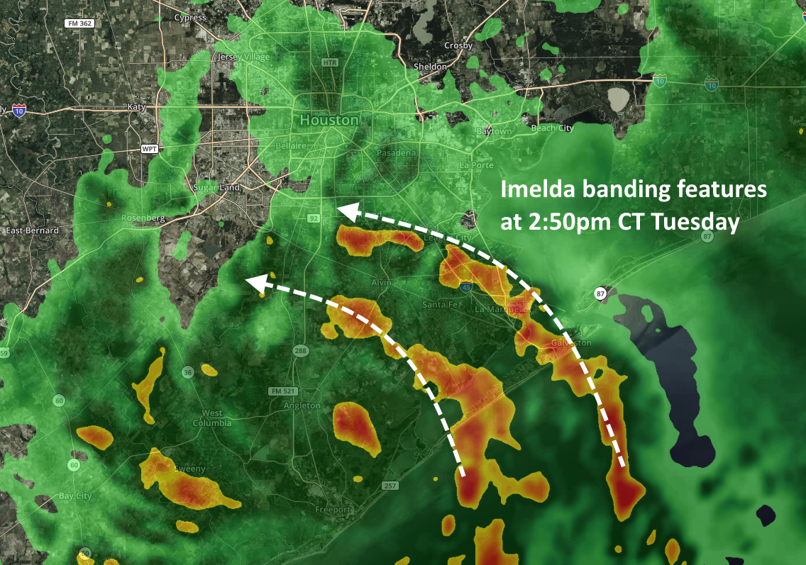
Probably the most notable shift in the modeling guidance has been an acceleration of when we expect heavier rainfall to begin. It now appears likely that heavier rains will move into Houston this evening, with banding features consistent with a tropical storm. We now also have increasing confidence that the worst of this will be over by Thursday afternoon or evening—so Houston appears to be locked into this mess for the next 48 hours or so. (It’s nice to have a fairly clear end point).
Tropical Storm Imelda banding on Tuesday afternoon. (kktv.com)
Tuesday night rains
A good portion of Harris County, and coastal counties, will likely see between 3 and 6 inches of rainfall this evening, during the overnight hours Tuesday, and through Wednesday morning. There may also be a narrower band that sees as much as 12 to 15 inches tonight, although it is not clear whether this will occur along the coast, offshore, or somewhere east of Interstate 45. Where this heavier rainfall occurs we probably will see significant street flooding due to extremely high rainfall rates, and potentially water getting into homes. During any flash flooding please remain in your location and do not venture out.
Wednesday afternoon through Thursday
As Imelda slowly lifts north, we expect the more intense band of rainfall to lift with it. So our biggest concerns for heavy rainfall later on Wednesday and Thursday will probably migrate to the Interstate 10 corridor and further inland. But frankly, we’ll have to reassess this after we get through Tuesday night.
As for overall event totals through Thursday, it seems a fair bet that most of the Houston metro area will pick up 5 to 10 inches of rainfall, with isolated totals of 20 inches or greater. Most likely these higher totals will occur somewhere east of Interstate 45, but whether that’s over Galveston Bay; East Harris County; or Liberty and Montgomery Counties, is difficult to say. More later. Hang in there, y’all.
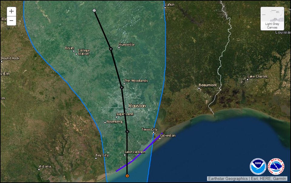
Today, the National Hurricane Center upgraded the low-pressure system in the Gulf of Mexico into a tropical depression. (Update: at 12:45pm CT the National Hurricane Center upgraded the system to Tropical Storm Imelda). As a result of this, a Tropical Storm Warning has been issued for the coast of Texas from Sargent to Port Bolivar. The storm’s forecast track, through Thursday morning, is shown below. The system should run rougly parallel to Interstate 45 once inland.
Official track for the depression from Tuesday at Noon CT through Thursday morning. (NOAA)
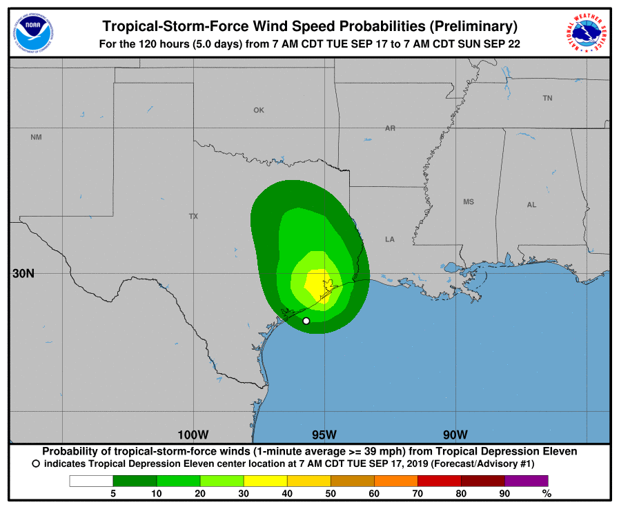
The formation of a depression increases the possibility—slightly—of this system bringing tropical storm-force winds into the Houston metro area later today and on Wednesday. However, the overall probabilities are low:
Probability that a given location will experience tropical storm-force winds. (National Hurricane Center)
By far the greatest threat from this system remains heavy rainfall from now through Thursday. As noted this morning, the depression is bringing an exceptional amount of tropical moisture into the state of Texas. What we don’t know yet is where the heaviest rains will fall on Wednesday and Thursday. We think a few areas—maybe some isolated locations in Galveston or Houston or Beaumont or Lake Charles—could see peak amounts of 15 to 20 inches. But most of our region probably will receive considerably less than that, on the order of 5 to 10 inches, which hopefully will be mostly manageable.
Bottom line, there’s a lot of potential here for heavy rainfall, and we’re going to have to really track this closely as it brings flooding into Southeast Texas on Wednesday and Thursday. We’ll have a comprehensive update around 4pm this afternoon outlining what we know, and what we don’t.