Here’s our new, revised Space City Weather Flood Scale

In the wake of Tropical Storm Imelda, Eric and I wanted to reintroduce the Space City Weather Flood Scale, as well as place that memorable storm in its proper context. We’ll tackle Imelda in a moment, but first just a a few words about the slightly revised flood scale.

(Space City Weather)

When we first introduced the flood scale, we didn’t really go too much depth on the various stages. We now realize that leaving any ambiguity in the interpretation of this was probably a mistake, so the goal here is to explain our scale in more depth and detail so readers have complete clarity on what it is meant to convey.

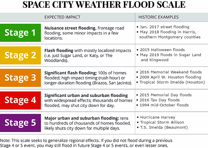
Origin & what it does

In the wake of Hurricane Harvey and all the flooding events in recent years, it occurred to me that we needed a way to put future rain forecasts in context with past events. Eric and I decided on a five-stage, or category scale. The scale is not meant to be perfect for everyone. Nor is it meant to replace forecast advice or direction from the National Weather Service or emergency managers. All it is meant to do is to set a realistic expectation ahead of a rainfall event that we feel could produce newsworthy flooding. We just want to attempt to help people navigate their anxieties regarding flooding that we know are widespread after recent years.

The scale is meant to characterize, in the general grand scheme of things, how the flood will be remembered for in Houston. Yes, your car may flood in a nuisance street flooding event, “only” a stage 1 on our scale. For you, personally, that may be a stage 5 life event. While that would certainly be unfortunate, for the greater Houston area, nuisance street flooding is rather common, and Stage 1 events happen at least a few times per year. What we want to do is make sure people understand that an upcoming rain event is more like that than a Memorial Day 2015 event, a Tax Day 2016 event, or an Imelda, and vice versa.

What it does not do

This scale is not going to tell you if you will experience flooding. Every flood event is unique. Just because you may have received 40 inches over 5 days and not flooded during Harvey, that does not mean you also won’t flood during a storm that only produces 6 inches of rain that falls in a single hour. Flooding in any given rainstorm depends on numerous factors, including quantity of rain, duration, intensity, neighborhood drainage, and conditions in place prior to the rain. Since no two storms are identical, you cannot always rely on past storms to tell you how future ones may impact you in your backyard.

The historic examples are not meant to apply perfectly to any one individual neighborhood. We may classify an event as stage 2 because it caused localized flooding in The Woodlands or Kingwood or Sugar Land. For some folks in those neighborhoods that flooded, that historic example may feel like a stage 3 or 4 event because of the problems it caused you and your neighbors. In other neighborhoods, you may not have noticed a drop of rain. What we want to do is put the event into context in the Greater Houston area. This scale is a perfect example of “your mileage may vary.” We recognize that, but we also know there is no perfect scale. This is the closest thing we could think of to a one-size fits all solution.

The scale is just attempting to characterize the “personality” of the flooding event we expect.

Let’s take you through each stage and discuss what each one means and what the past events did.

See full post

A wet morning front will bring a couple of cooler days to Houston

Good morning. After a hot day Tuesday—high temperatures peaked at 92 degrees—a cool front is pushing through Houston this morning and will be off the coast shortly after sunrise. The front has generally brought 0.25 to 1.0 inch of rain to the area. We’ll see some roller coaster weather through the weekend, with cold then warmer days, before a more prolonged stretch of cooler conditions next week.

Wednesday

Some light rain may linger behind the front’s passage, but for the most part today should simply bring gray skies and at-times gusty northerly winds. High temperatures today will likely stall out in the mid- to upper-70s for most of the area. There’s not an overly amount of cooler air with this front, so overnight lows may drop into the upper 50s for inland areas, but remain in the low 60s near the coast as skies stay cloudy Wednesday night.

Thursday morning’s low temperatures will be quite pleasant. (Pivotal Weather)

Thursday

This should be an awfully nice fall day, with highs generally in the low 70s and partly sunny skies. Low temperatures Thursday night will be similar to Wednesday night, albeit perhaps a degree or two warmer.

Friday

Warmer conditions as the onshore flow resumes, but highs should still be capped in the low 80s, with mostly sunny skies. We can’t rule out the possibility of a few isolated showers.

Saturday

The first half of the weekend looks warm and sunny. Expect highs in the upper 80s with very little chance of rainfall. Saturday and Sunday may be the region’s last, realistic shot at hitting 90 degrees this calendar year.

See full post

Astros/Yankees ALCS forecast about to be thrown a curveball Wednesday

Besides caring about the weather here at Space City Weather, Eric and I also care about the Astros. So with that in mind, we want to update our readers on the weather for games 3, 4, and 5 of the American League Championship Series up in the Bronx. And believe me, weather is going to play a big role in the balance of this series.

Game 3: Today 3:08 PM

This afternoon’s game should go off trouble-free. Expect a good deal of sunshine for the game. First-pitch temperature should be in the mid-60s with light winds.

Game 4: Wednesday 7:08 PM

There has been talk about game 4 for a few days now, and we are here to tell you: We don’t think game 4 will be played on Wednesday.

A look at a loop of the GFS model here shows a coastal storm developing tomorrow evening south of Long Island.


The very latest GFS model shows a potent coastal storm in New England tomorrow that will bring rain to New York City beginning Wednesday afternoon. (Tropical Tidbits)

This one really cranks up in the evening and will deliver heavy rain and strong winds to New Jersey, New York City, and much of New England, possibly ending what has been a pretty decent foliage season in that corner of the country. More importantly, for the Astros and Yankees and their fans, this throws a big wrench into game 4 plans. Rain should begin in New York City around 2 PM or so. Here’s a look at the rainfall expected from the GFS model between 8 PM and 11 PM EDT, within the scheduled window for Game 4.

Forecast rainfall from the GFS model between 8 PM and 11 PM EDT on Wednesday, or during the scheduled time of the Astros game. (Weathernerds,org)

That suggests that there will still be heavy rainfall in the Bronx during the evening hours. Unless something dramatically changes, we think game 4 will be postponed and moved to Thursday. Oh, and in addition to rain, this storm will produce some pretty gusty north winds in NYC, perhaps topping out around 30 to 35 mph on Wednesday evening. So, yuck.

Game 5 (or game 4 makeup): Thursday 7:08 PM

Look for a breezy day in the Big Apple on Thursday. Winds will be diminishing Thursday evening, but we should still see sustained west or northwest winds at 15 mph or so. West winds would be straight out to right-center field, while winds out of the northwest would be from left to right across the outfield, meaning the short porch in right could get some love in this one. But, with that in mind, temperatures will be notably colder Thursday evening. Expect first pitch temperatures around 55 degrees, dropping into the low-50s through the game. The combination of a breeze and cooler temperatures will give this one a decided autumn feel.

Friday

If game 5 gets pushed to Friday, I think the start time would depend on whether the NLCS is still ongoing. Either the matinee slot or the evening slot will feature cool, breezy, dry weather. Winds should be from the northwest around 10 to 15 mph (possibly gustier with a day game). Temperatures would fall from the low-60s to upper-50s in a day game. In the evening, we would see temps drop from the mid- to upper-50s into the lower-50s.

We won’t make any predictions on which team a Wednesday rainout would benefit. But it certainly could alter how the managers approach their strategy this afternoon and in games 4 or 5. We shall see! We hope you find this helpful, and let’s go Astros!

Have no sorrow—hot today, but cool tomorrow

You know the late-summer heat is getting to me when I start to write rhyming headlines. But here’s the deal. It’s going to be pretty hot today, and then fairly warm again this weekend after a brief front. However, after we get through about next Monday, I think we’re pretty much done with any chance of hitting 90 degrees for the rest of 2019.

Tuesday

As noted above, today is going to be quite hot. The western half of the metro area has a strong chance of reaching 90 degrees—it’s all going to depend on how much sunshine can break through the clouds. But certainly it will be sticky today and this evening. The other story for today will be the approach of a cool front tonight, which should drive showers and thunderstorms after sunset Tuesday. It looks as though the best dynamics for any storms and heavier showers should be north of Houston—perhaps northwest of a line from The Woodlands and Brenham. However areas north of Interstate 10 probably have a good chance to pick up 0.25 to 1 inch of rain tonight, whereas areas closer to the coast probably will see a little bit less than this.

Some parts of the Valley could reach 100 degrees on Tuesday. (Weather Bell)

Wednesday

The front itself should push into the metro area after midnight, and off the coast by mid-morning or noon at the latest. Some light showers may linger in the wake of the front, but mostly this should be a cloudy day, with highs in the 70s and a cool northerly breeze. Lows Wednesday night should drop down to around 60 degrees.

Thursday

This should be another cloudy day, albeit with the possibility of some partial clearing during the afternoon. High temperatures will work their way into the mid-70s. Low temperatures on Thursday night should be a few degrees warmer as the cool front washes away.

See full post