When is the best time to have an outdoor wedding in Houston?

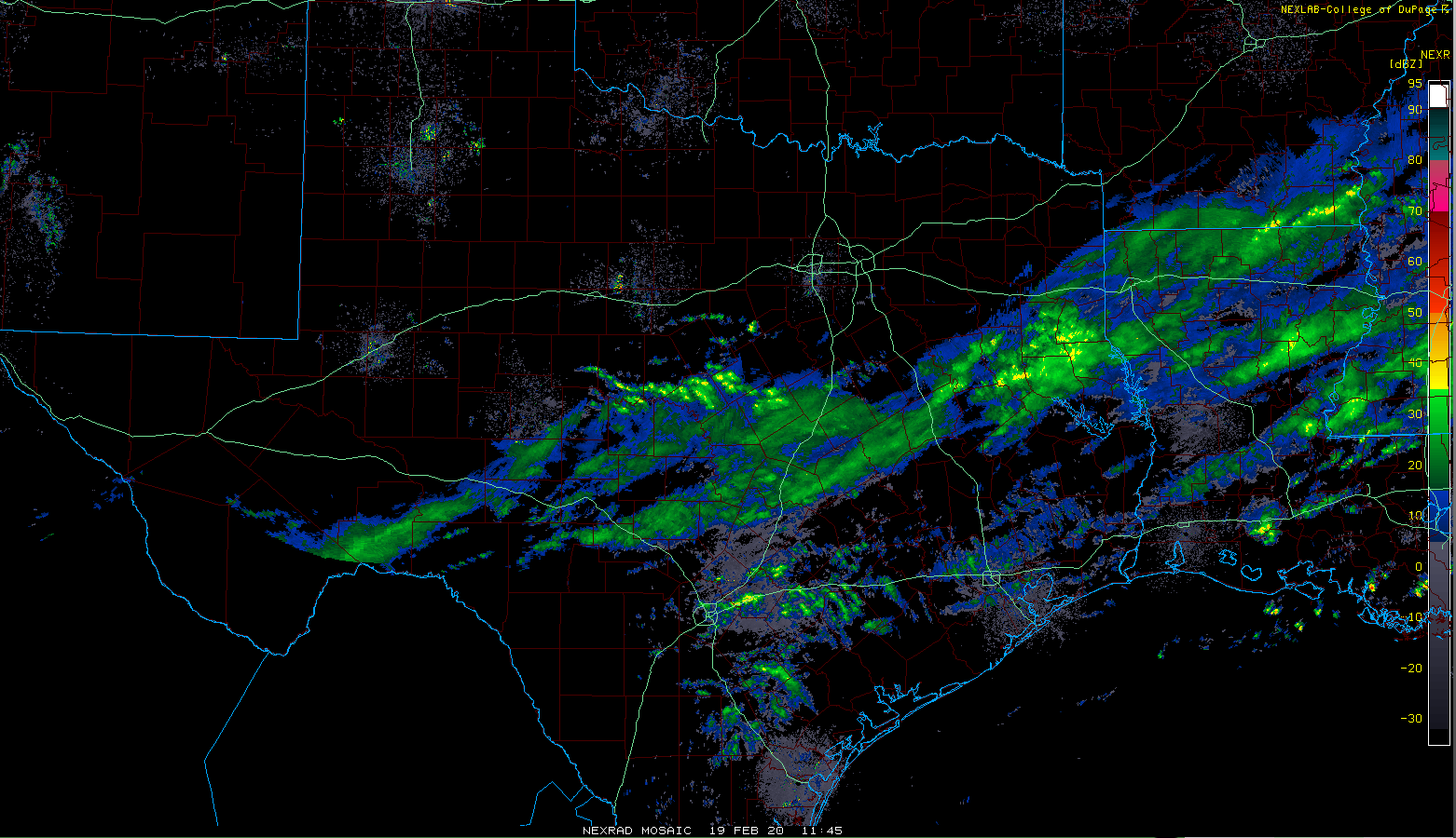
Good morning. A line of showers and thunderstorms is moving through Houston this morning from west to east, and this should be the last rain before an exceptionally sunny week. Seriously, we should see a stretch of at least six sunny and mostly cool days—lovely late winter and early spring weather.

Before jumping too far into the forecast, however, I wanted to answer a question from a reader that I think others might find of interest. Lee Sharp writes to say that he and longtime girlfriend Aida Gonzalez are ready to tie the knot:

“We have this amazing backyard, and really want an outdoor reception. But Houston weather being what it is, and the advance lead times needed for a weeding… So, when is the best time of year for an outdoor event? Not being rained out is first priority, but also not having everyone die of heatstroke is important as well. So what do you think?”

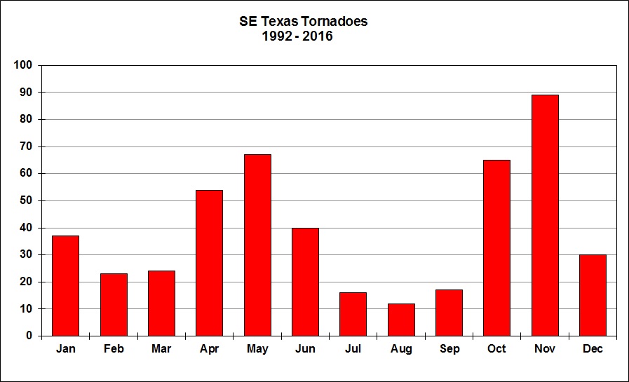
The easy answer is not summer! So we can rule out the period of June through September due to heat and humidity. I’m going to take away December through February too, because while it doesn’t necessarily get all that cold in Houston, it can get quite chilly and blustery during the winter months. This leaves us with March, April, May, and October and November. Of those five months, March (3.20 inches) and April (3.25 inches) have historically the lowest annual rainfall totals—more than one inch below the other contending months. Late March actually has the lowest daily chance of precipitation of any time of year, 21 percent, compared to 40 percent in mid-June. The chance of rain is even lower during the evening hours, falling below 4 percent. Finally, April and May are subject to spring storms, and October and November are subject to stronger storms and tornadoes as well.

All tornadoes, by month, since 1992 for the southeast Texas region. (National Weather Service)

All of this leaves the obvious conclusion that March is the “safest” month to plan an outdoor wedding in Houston, although there really is no “safe” time. It is historically the driest month, with a generally mild climate (average high 72.4 degrees), and if you’re having a backyard wedding I imagine flowers and gardens and trees are starting to bloom nicely later in the month. So to pin things down even further, the best time for outdoor weddings in Houston is the last two weeks of March, during the afternoon or evening hours.

Monday

A line of showers and thunderstorms should move southeast across the area and offshore by around noon today. Most parts of Houston will see less than one-half inch of rain but a few stronger storms could generate isolated areas of 1 inch of rainfall or more. High temperatures today will reach the mid-70s under mostly cloudy skies. A weak cool front will sag into the area this evening, helping to drop temperatures to around 50 degrees Monday night under mostly cloudy skies.

See full post

A superb stretch of weather lies ahead for Houston

Skies are—drum roll, please—clear this morning! High pressure moving into the region has pushed cloud cover out of Houston, and so we should have several sunny days. In fact, aside from some clouds on Sunday and Monday, most of the next week should bring lots of sunshine to the region as well as mostly dry air.

Friday

It’s quite cold to start today, so bring a jacket as you head out the door. After breezy overnight conditions, winds should subside this morning. All of the cool air moving in with the overnight winds will help to limit high temperatures to the mid-50s today, despite the ample sunshine. The combination of dying winds and clear skies should set up for ideal cooling tonight, with a light freeze possible in Montgomery County and areas to the northeast of Houston.

Low temperatures on Saturday morning will be quite cold. (Pivotal Weather)

Saturday

Sunshine should persist through at least Saturday morning, although I expect to see at least some high clouds move in during the afternoon hours. This should still be a pretty darn nice day, with highs of about 60 degrees, and light winds. As high pressure exits to the east, winds will pick up from offshore later Saturday, probably during the evening hours. Pretty quickly this will help to spin up at least partly cloudy skies, and moderate overnight lows to about 50 degrees in the city of Houston.

See full post

One more cold, soggy day before sunshine makes its return to Houston

Houston’s last stretch of clear skies came all the way back on Valentine’s Day, during the evening hours. We’ve now got to slog through one more gray, wet, and windy day before we get back to sunny weather for a couple of days. Clear nighttime skies will also allow for cooler temperatures, with the northern half of the metro area flirting with a freeze.

Thursday

A cold front is pushing through the metro area this morning, bringing widespread, mostly light rain with it. Accumulations will total one to two tenths of an inch. These showers should slowly dissipate throughout the day, with northwestern areas drying out first, and the coast later this afternoon. In the meantime, we’re going to see a chilly day, with a distinct lack of sunshine helping to hold high temperatures at about 50 degrees. Winds blowing up to 20mph out of the north will not help matters any, either. As skies clear tonight, lows will drop to around 40 in the city of Houston, with cooler temperatures north, and a bit warmer weather near the coast.

Friday night’s low temperatures may bring a freeze to parts of Montgomery County. (Pivotal Weather)

Friday

After a chilly, breezy start on Friday morning, winds should begin to die down. But with colder air across the region, highs likely will top out in the mid-50s despite the sunny skies. Continuing clear skies and light winds Friday night should allow for ideal cooling and the coldest night of the week for most of the Houston region (see map).

See full post

Spring fling ends as Houston descends back into something more like winter

As expected, we ran for 80 degrees yesterday but came up just short, hitting 79° at Bush and Hobby. Today, many of us will probably not even get to 60°.

Today

It’s a much colder start to the day today for sure.

This map shows how much temperatures have changed since the same time yesterday. We are running about 15 degrees colder than Tuesday morning. (NOAA)

Temperatures across most of the area are running about 15 degrees colder than yesterday at this time. At the coast, it’s a bit less than that. Our current temperatures will not move a bunch either. Look for high temperatures to perhaps end up only 2 to 4 degrees warmer than where they’re at this morning. Basically, expect 50s all day today inland, near 60 at the coast.

How about rain? Well, if you live in Houston or Harris County and points south and were hoping for rain by now, you’re probably getting a little frustrated. Like we told you yesterday, the bulk of the rain was expected to stay north of Houston, and it did, way north. We’re starting today similarly.

While there may be light rain, drizzle, or mist this morning, the bulk of any steady rain is staying well north of Houston. This should mostly continue until tonight. (College of DuPage)

The steadiest rain this morning is way up north between Huntsville and Corsicana. In the Greater Houston area? Light rain, drizzle, mist, and nothing more than a couple passing showers. This should be the case for the majority of the day today, with perhaps that steadier rain nudging south late toward Huntsville or Conroe.

Tonight

Rain will continue slowly dropping southward late tonight, but the whole system will begin to also lose steam. The current thinking is that most areas north of I-10 will see at least some rain, with the heaviest amounts being, again, way north toward College Station, Huntsville, or Lake Livingston, possibly even north of there. The whole mess drops, somewhat disjointed into the rest of the area overnight. We could see some heavier showers or thunder along the coast late tonight.

Temperatures will drop to the low- or mid-50s south and upper-40s north by Thursday morning.

Thursday

The entire system will basically fall apart over us, meaning rain chances will gradually trend downward through the day, with rain mostly ending by afternoon. Clouds should linger, and much like Wednesday, temperatures will probably end the day near where they begin the day. Look for temperatures in the upper-40s or low-50s most of Thursday.

As noted yesterday, the wind is expected to whip up on Thursday too. An offshore breeze of about 15 to 25 mph will build during the morning or early afternoon inland, with 20 to 30 mph winds and higher gusts over the bays and along the coast.

See full post