Steadier rains mainly north of Houston through Wednesday

Houston officially topped off at 81° yesterday, our warmest February day since way back on February 6th, when we hit 82°. More importantly, we had some sunshine yesterday, which was a pleasant surprise. We won’t be seeing much more sun until Friday.

Today

Today is starting off cloudy inland and foggy along the coast. We probably won’t see much change in that situation through the day today.

In terms of rain chances today, those will be highest north of about The Woodlands, so from Navasota over to Conroe up through Huntsville and over toward Lake Livingston; basically along or north of Highway 105. Some of the rain could be heavy at times later this afternoon up that way, and thunder will be possible too. Closer to Houston or the coast, a few showers will be possible through this afternoon but they will probably not amount to much.

Oh, and it’s going to be a warm one again today. We should make another run toward 80 degrees this afternoon, but with more clouds than yesterday, we will probably end up a little short.

Tonight

The cold front will be located somewhere north and west of Houston early this evening, probably from about Lake Livingston through Conroe through about Sealy. Through the evening, the cold front will progress into and beyond Houston to about the coast by midnight or so. Look for scattered showers and a chance of thunderstorms tonight.
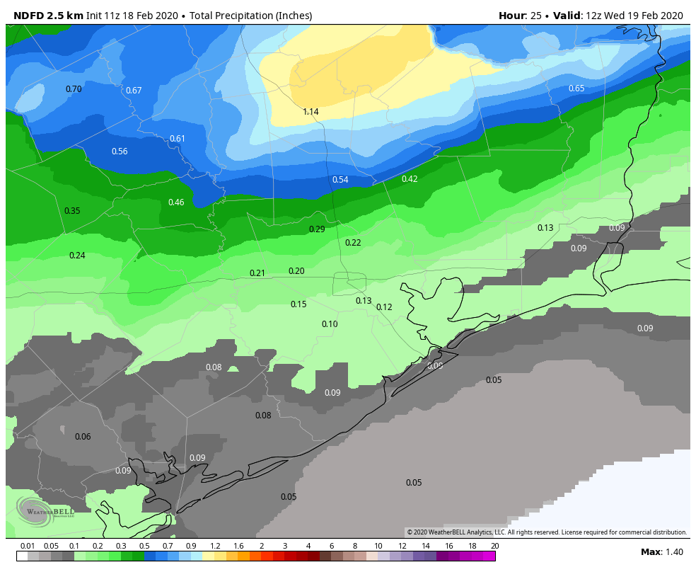
Total rainfall through Wednesday morning will be highest along Highway 105, lowest near the coast. (Weather Bell)

Rain totals will be highest today and tonight to the north of Houston. It is possible that some folks from I-10 southward may not even see a drop of rain. I would expect a range of 0.10 to 0.25 inches of rain on average along and south of I-10 through Wednesday morning, increasing to 1 to 2 inches or so north of Conroe. A couple spots up from Conroe or Huntsville over to Lake Livingston could see as much as 3 inches or so if we see slower moving, better organized thunderstorms later today and this evening.

Temperatures aren’t going to plummet behind this front, but they will drop about 10 degrees in its wake, from the 60s into the 50s this evening. By daybreak Wednesday, we should be in the low-50s or upper 40s from Houston north and mid- to upper-50s south.

Wednesday

Despite the front being offshore, Wednesday will be a cloudy day. Showers or light rain will be ongoing in parts of the area. The most sustained rainfall on Wednesday should again be along or north of Highway 105, so we’re talking Aggieland through Conroe. We could see upwards of another inch or so in those parts. Rain may fall steadier than today a bit farther south tomorrow, closer to Tomball or The Woodlands. But in the Houston area and points south, expect only occasional light rain, drizzle, or showers.

Temperatures are not really going anywhere tomorrow. We will probably finish the day within a couple degrees of where we start the day. So, dress for generally middle 50s, perhaps a bit milder south or colder north.

See full post

It’s going to be a gray and rainy week for Houston

Houston will remain in a gray, humid funk until Tuesday night when a cold front pushes through the area. However, this front is not going to scour moisture from all levels of the atmosphere, so we’re going to see very good rain chances on Wednesday and Thursday before another front clears us out. Don’t expect to see much sunshine until Friday, at the earliest.

Monday

Patchy fog should clear out by mid-morning, leaving behind a mostly cloudy and warm day with highs in the mid- to upper-70s. Some very light showers will be possible later today, but mostly skies should just be gray. Winds will be out of the south, gusting up to 20 mph and really pumping moisture in the region. Look for low temperatures only to fall into into the upper 60s tonight.

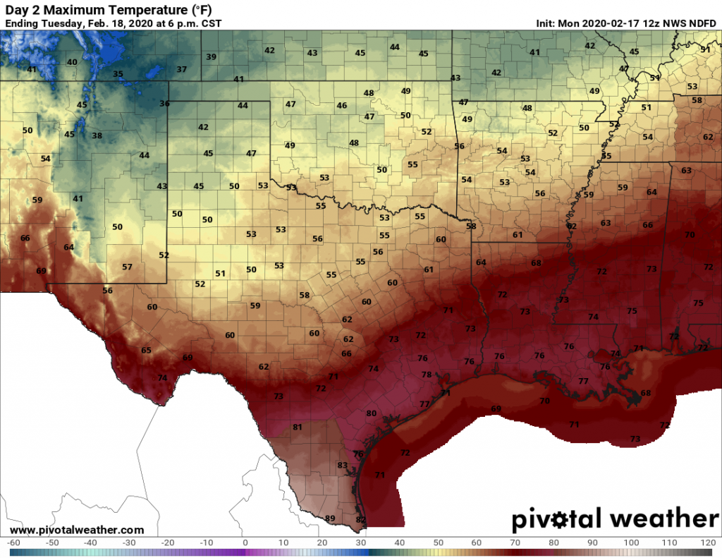
Tuesday’s high temperature forecast shows where the front will reach, and where it won’t. (Pivotal Weather)

Tuesday

This day will be similar to Monday in terms of fog and temperatures. The only difference is that a cold front will approach the area from the north, and bring an increased chance of rain. This will be especially true for northern areas, such as Montgomery County, which may see as much 0.5 inch of rain whereas the coast sees little to none. The front itself pushes into the area on Tuesday night for the northwest half of Houston, and likely sometime Wednesday morning for coastal areas.

See full post

Nice Friday, warmer weekend, but back to winter by later next week

Happy Valentine’s Day, an important day in southeast Texas weather history! We have at least a couple more nice days ahead before some pretty significant changes slowly evolve next week.

Today

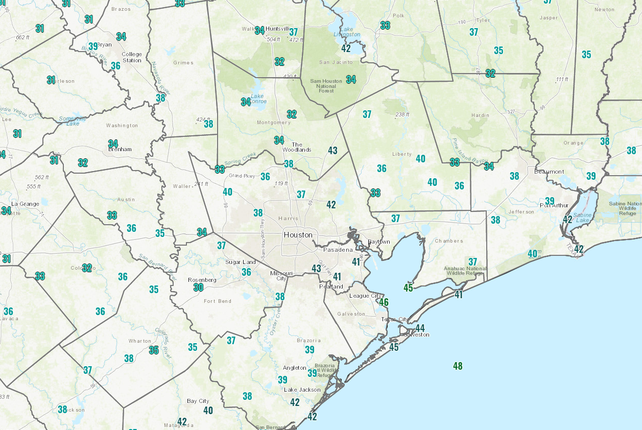
It’s a bit cold this morning. Temperatures are in the upper 30s to low 40s on average. A few isolated spots north of The Woodlands or out by Rosenberg in Fort Bend County are near or below freezing this morning.

Temperatures as of 5:30 AM Friday are in the 30s and 40s, with a few locations near freezing on the edge of the Houston metro area. (NOAA)

The chilly temps are partially because skies are clear, which means gorgeous weather is expected today. Sunshine should dominate with mostly light winds, though a bit breezy at times still on the Gulf and in the bays. High temperatures will warm up to near 60 degrees.

Saturday

Tonight will be cool, but temperatures will be a few degrees warmer than this morning’s lows. Look for 40s in general, followed by sunshine once again for Saturday. Clouds should become a bit more noticeable as the day goes along, and high temperatures will be a bit milder. We should top off in the 60s in most spots, perhaps near 70 if clouds are slower to arrive.

Sunday

Clouds thicken up Saturday night and Sunday. With the clouds could come a few showers, especially south and east of Houston. Additionally, some fog may develop by Sunday morning in spots. Otherwise, it will just be mostly cloudy and mild, with highs reaching into the 70s after morning lows in the 50s.

See full post

Winter returns for a bit, and the weekend outlook improves

What a difference a day makes. With clearing skies and dry air, lows this morning have fallen into the 40s across the Houston area. Our forecast for the weekend continues to improve as well, now with at least some sunshine possibly breaking out over the area and diminishing rain chances. Looking a bit further ahead, a stronger front may bring a bit more of a prolonged period of cooler weather next week.

Thursday

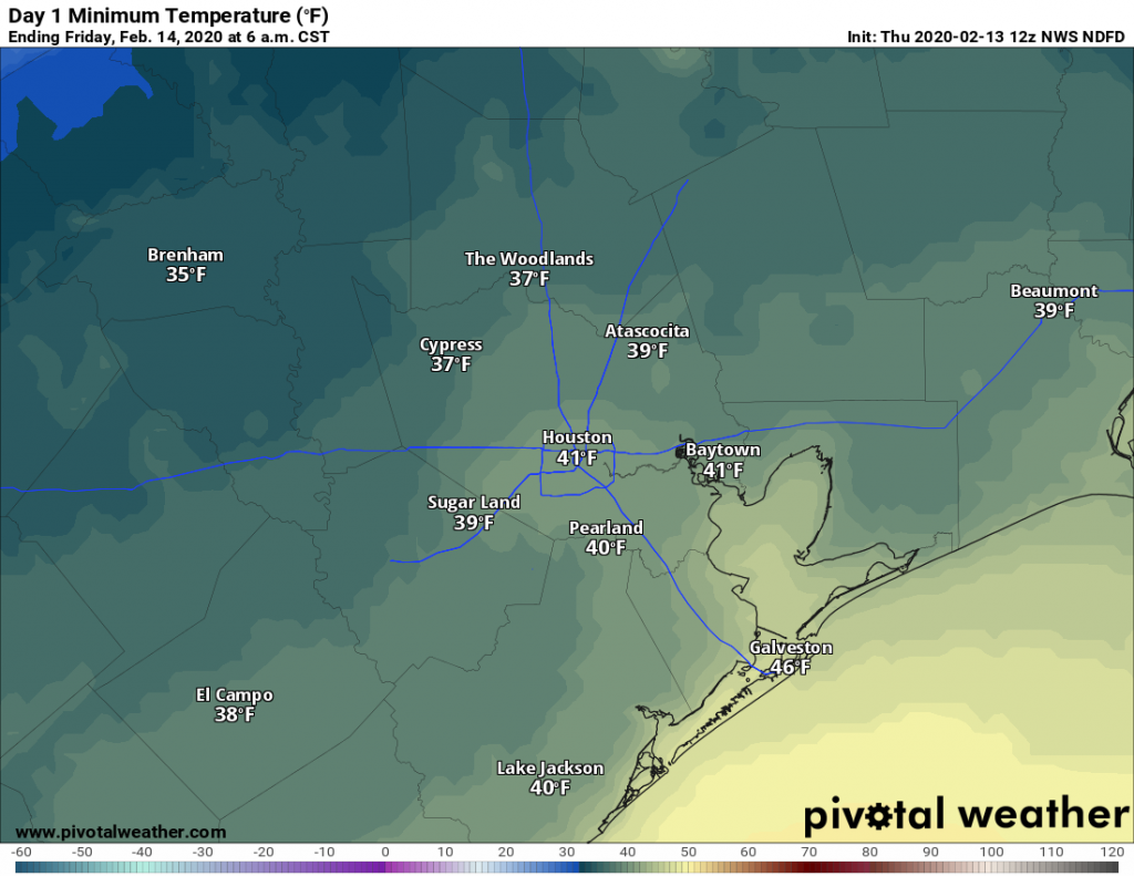
Sunshine will prevail for most of the day Thursday, with high temperatures likely holding in the upper 50s. Northerly winds will blow at about 10 mph, gusting perhaps a bit higher, which should be enough to keep a decent chill in the air. Clear skies and light winds will push overnight low temperatures down into the 30s for most inland areas of Houston—although the entirety of the metro area will probably remain above freezing.

Expect a cold night Thursday night across Houston. (Pivotal Weather)

Friday

Another pleasant winter day, with sunny skies and high temperatures near 60 degrees. Winds shifting to come from the east should allow for Friday night’s low temperatures to settle in about five degrees warmer than Thursday night.

See full post