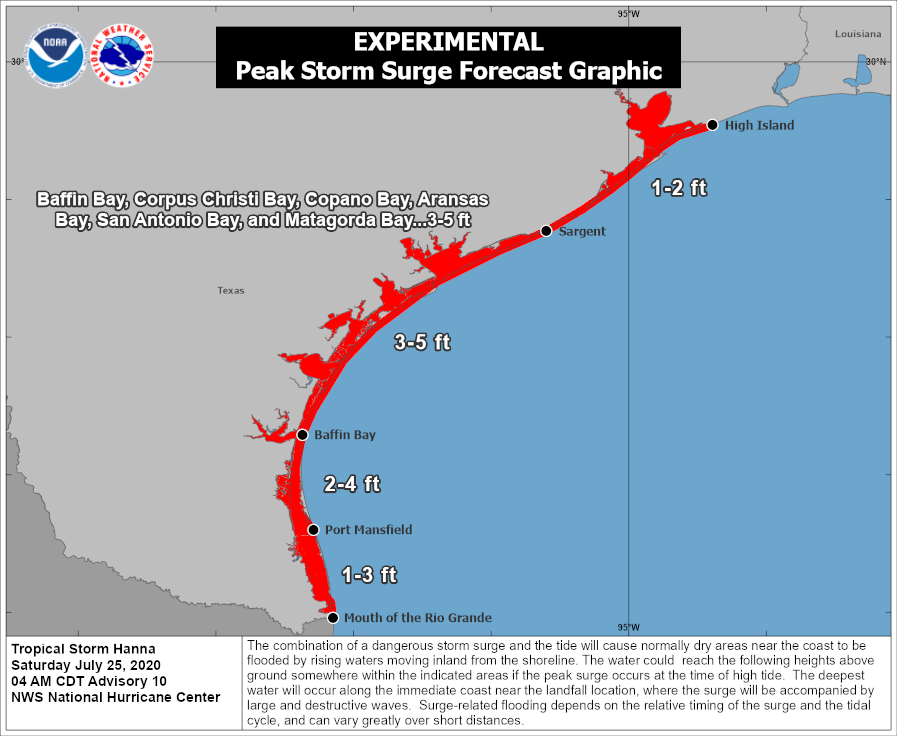
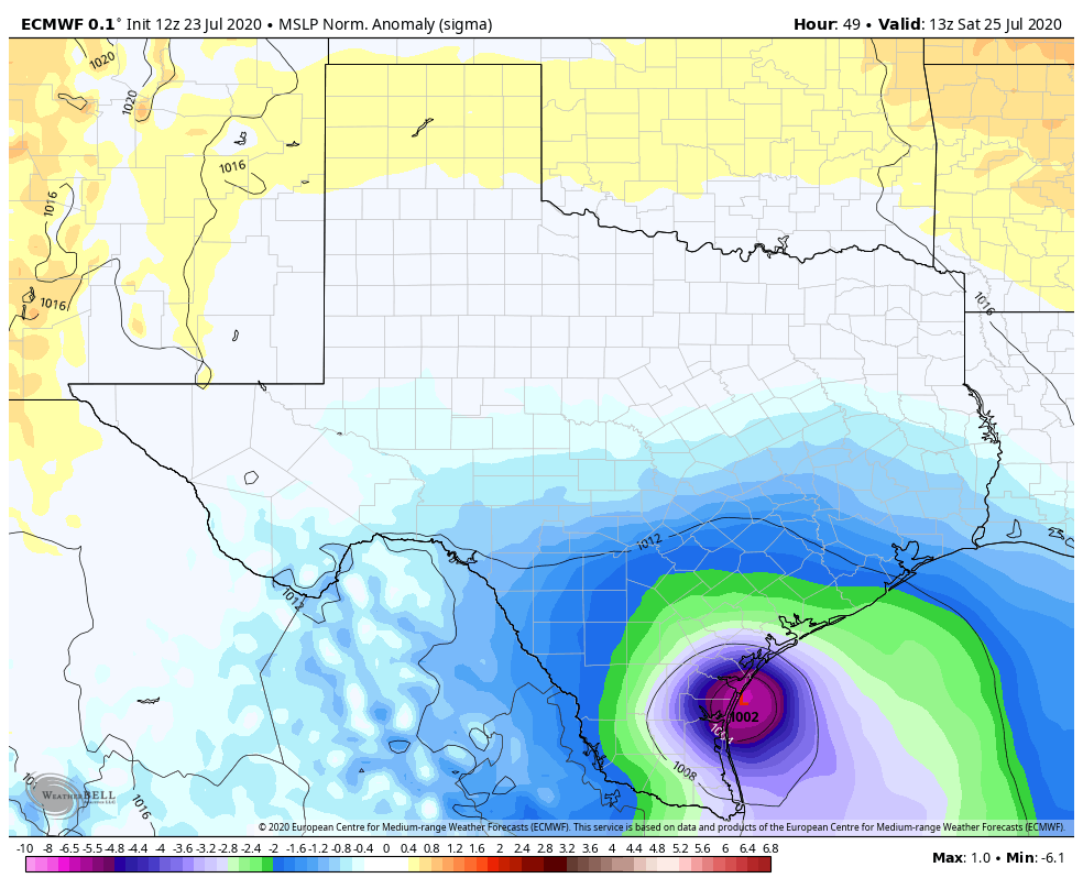
Good morning. As of 7am CT, the National Hurricane Center has just upgraded Hanna to hurricane status, with sustained winds of 75 mph. The storm should make landfall near or just north of Port Mansfield later today, and may strengthen further before doing so.
Storm surge projections for Hurricane Hanna. (National Hurricane Center)
For the greater Houston area, this ultimately will probably yield little change to our overall forecast for a rainy and breezy weekend. We are going to see elevated tides along the coast of 1 to 3 feet from Freeport to Galveston, and along other coastal areas. In addition, these regions near the water will see some stronger winds, with gusts likely above 30 mph, while inland areas see gusts of 25 mph or above.
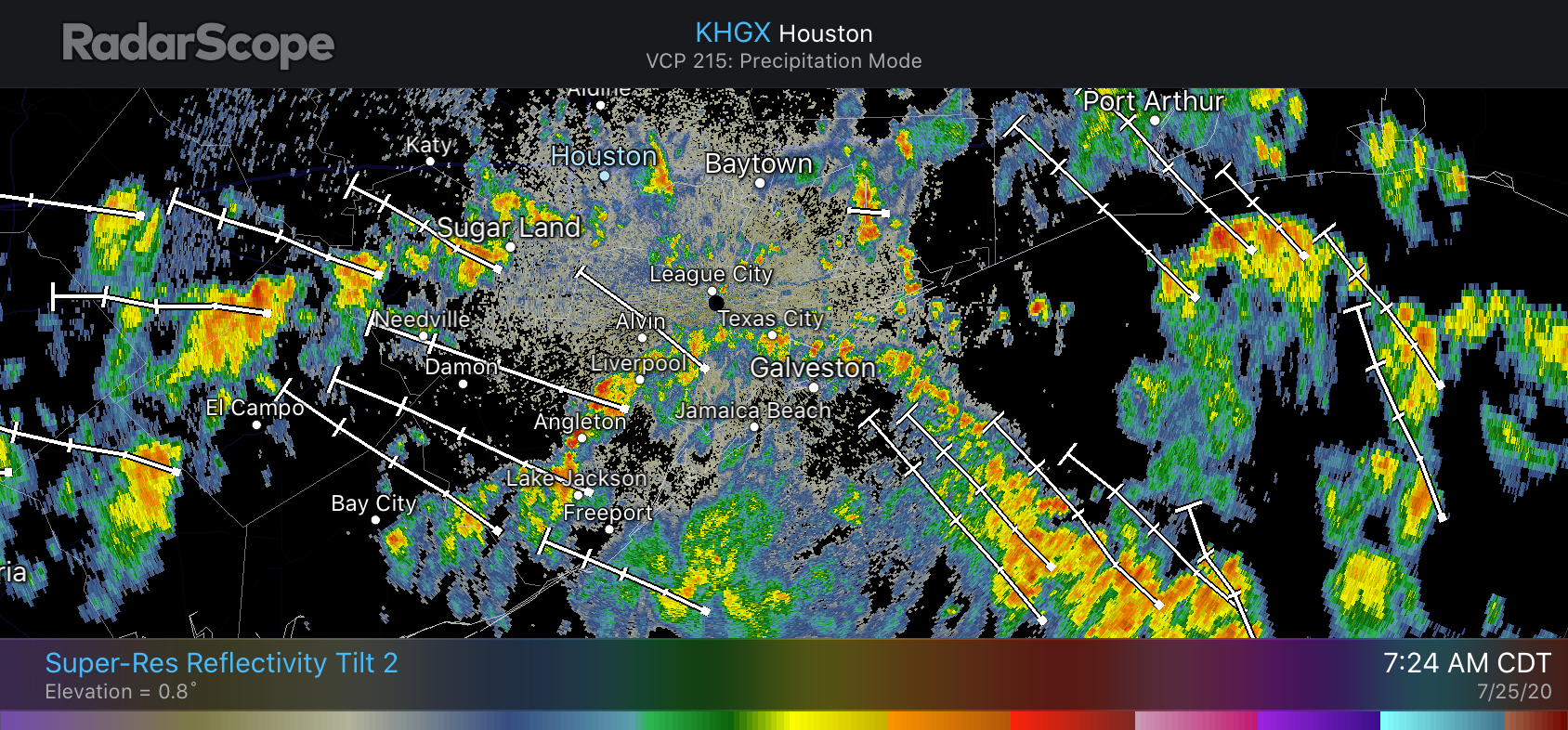
Houston radar at 7:24am CT on Saturday. (RadarScope)
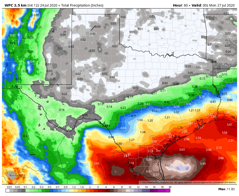
In terms of rainfall, we’re still expecting a wet weekend, with 2 to 4 inches of rainfall coming down across most of the area as Hanna’s outer rain bands traverse the area. Generally, these bands should be spread out, and keep moving—helping to limit accumulations. Some streets may briefly flood due to high rainfall rates, however. We can’t rule out some isolated accumulations of 6 or more inches over the southern part of the Houston region.
Healthy rain chances will continue through Monday or Tuesday before we finally return to somewhat more normal weather for summer, which is to say highs in the low 90s and scattered afternoon showers.
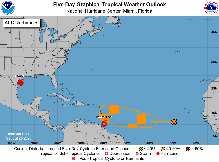
Hanna, Gonzalo, and a third tropical system. (National Hurricane Center)
After Hanna moves off, the tropics should remain active. While Gonzalo is expected to die in the southern Caribbean Sea there is another system behind it that will be spinning westward across the Atlantic Ocean toward the Caribbean. Most of the global guidance is bullish on this system eventually becoming a hurricane (it would be named Isaias), and it will probably be something for the islands, and eventually the United States to track. But it will be several days before we have any sense of where the storm may ultimately go.
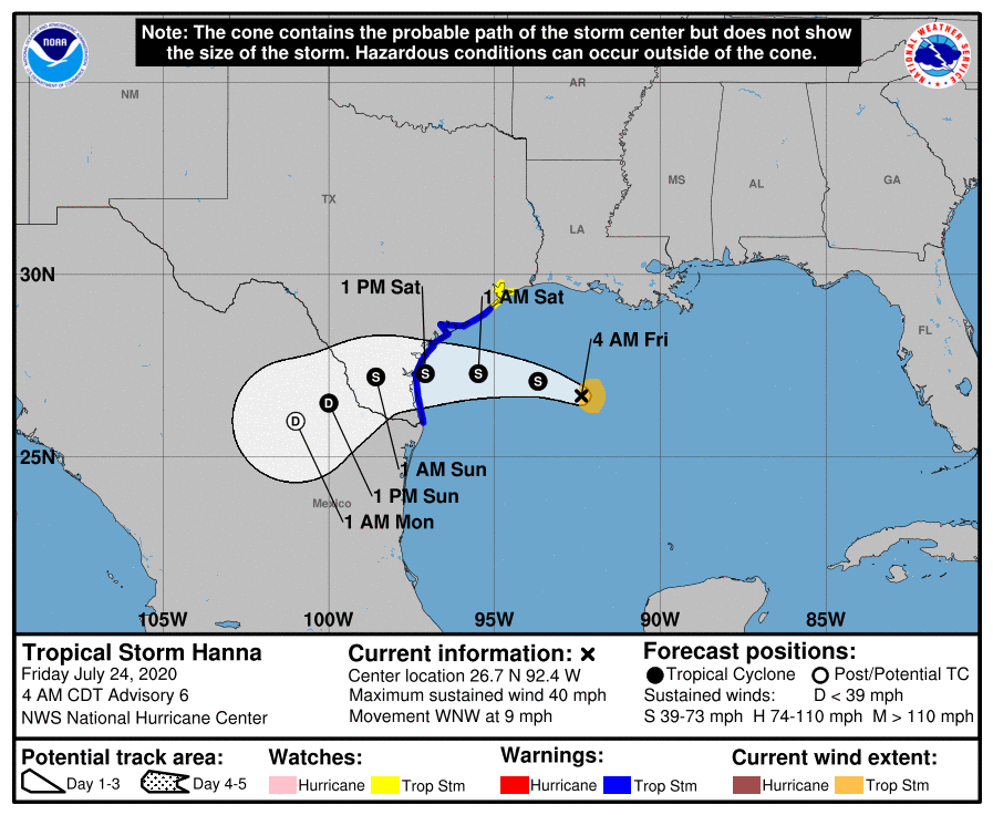
Good morning everyone. Tropical Storm Hanna formed last night, and it wasted no time gradually getting itself organized. As this has been happening, Hanna’s forecast track has continued to shift south, taking most of the significant impacts expected from the storm out of the Houston area. A lack of significant impacts doesn’t mean we’ll have zero impacts, however, so we’ll break down what to expect here and farther south in Texas as well.
Now
As of 5:30 this morning, Hanna was over the Gulf, about 300 miles east-southeast of Corpus Christi. Hanna was moving slowly but steadily just north of due west, around 10 mph or so. Maximum sustained winds were estimated to be 40 mph, but a reconnaissance aircraft from NOAA is headed into the storm to see if that hasn’t increased somewhat. Based on Hanna’s satellite presentation, we can assume it probably has strengthened a bit.
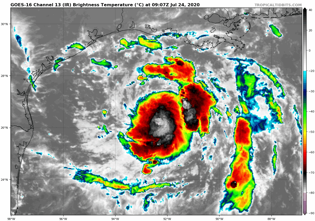
Tropical Storm Hanna on Friday morning had a lot of storms, though most of them were somewhat displaced to the south and east of the center as it tracks west toward South Texas. (Tropical Tidbits)
You can see a robust area of thunderstorms near the center of the storm. If you want to lodge a meteorological complaint about Hanna, it would be that the vast majority of thunderstorms are displaced to the south and east of the center of the storm. In other words, despite the pretty serious look on satellite, the storm does suffer a bit from a lack of symmetry that could indicate that while it’s strengthening, it may not be taking off like a rocket. It is likely still feeling a bit of wind shear, especially on its eastern fringe that is holding it back a little. Still, this is not an unhealthy storm and forecasts of strengthening up through landfall will likely come to pass.
The current National Hurricane Center forecast tracks Hanna toward the coast, arriving tomorrow midday somewhere between about Corpus Christi and South Padre Island, likely close to Baffin Bay.
The official NHC forecast continues to keep Hanna well south of Houston, with the most significant impacts in South Texas, while our area sees mostly nuisance-type impacts. (NOAA)
This will direct the most significant tropical impacts south of Matagorda Bay. Hanna keeps moving west and then southwest into Mexico, where it should dissipate on Sunday night or Monday.
Quick overview of what to expect for the Houston area
Here’s a quick “user’s guide” for what to expect in the Greater Houston area.
Rain: Isolated storms Friday, scattered storms Saturday, more numerous storms Sunday and maybe Monday. Rain totals of 1 to 2 inches on average, with higher amounts possible anywhere, but especially the farther south you go, possibly in excess of 3 or 4 inches in Matagorda. Lesser amounts possible north.
Flooding: Some street flooding is possible with any downpours, as is always the case in our area. Significant, widespread street or bayou flooding is not expected.
Wind: You should not expect winds to get much past 15 to 20 mph in the Houston area. Tropical storm conditions should be confined to the coast, with gusts up to 30 to 35 mph in Galveston and perhaps a bit stronger toward Freeport and the Matagorda Bay region.
Tidal & marine impacts: We expect tides to run about 1 to 3 feet higher than normal for Galveston and maybe a tinge higher toward Matagorda Bay. Minor overwash or tidal flooding is possible. Rip currents will be strong, so please use extreme caution. Waves are expect to be about 4 to 6 feet, maybe higher farther south.
Severe weather: Brief spin ups are possible in thunderstorms, especially as you get close to the coast, where a waterspout or two could occur.
Details for the Houston area
For today, we would anticipate isolated to perhaps scattered showers and storms. Expect a general trend of storms near the coast this morning, spreading inland this afternoon. Some locally heavy downpours are possible, but today should not be much worse than a typical summer day.
As Hanna approaches the south Texas coast tomorrow, expect the potential for steadier, heavier rain south of Houston. This would include Galveston, but we would especially include far southern Brazoria, Matagorda, and Jackson Counties. Tropical Storm Warnings are hoisted from San Luis Pass southward, so those areas are the ones most likely to also see tropical storm conditions. Showers and storms to the north of there will be mostly scattered on Saturday. In other words, some of us will see some heavy downpours, others may not see much of anything. The chance of heavier rain is obviously higher the farther south you go in the area.
The Houston area’s best chance at more numerous showers and storms and heavier rain will probably come Saturday night and Sunday as a surge of moisture comes in off the Gulf and out of Louisiana. That may continue off and on into Monday as well. By Tuesday and Wednesday, we should slowly return to a more typical summer pattern, with hotter weather.
When all is said and done, we expect probably 1 to 2 inches of rain on average in the Houston area, with a skew toward higher amounts south of the city and lower amounts to the north.
The current forecast of total rainfall is about 1 to 2 inches on average for the Houston area. The big ticket rainfall totals from Hanna will likely be south of Corpus Christi and in the Rio Grande Valley (Weather Bell)
However, depending on exactly how storms set up on Sunday, we could see as much as 2 to 4 inches of rain in spots, with the highest likelihood of this being south of I-10 and on the south and east sides of US-59/I-69.
Houston has about two more months to go, in terms of prime time, for the 2020 Atlantic Hurricane Season. As long time readers of this site will know, the odds of Texas being hit by a hurricane after September 24th, are quite low. By all appearances, the next two months in the tropics will be quite busy, with the Atlantic’s Main Development Region already starting to heat up. So we are going to have plenty of systems to monitor. To survive this period of anxiety, therefore, we should prioritize which tropical systems are worth worrying about.
And we’re here to tell you, Houston, Tropical Depression Eight does not have the look of something we think the greater Houston area should worry too much about. The usual disclaimers apply, of course. This is the tropics. Things change. But at this point we’re trending toward moderate to minimal effects.
(Space City Weather)
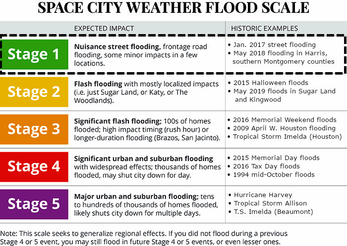
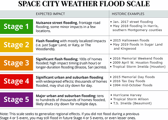
To that end we’re lowering the entire metro area to a Stage 1 flood alert on our flood scale, bringing the coastal areas (previously Stage 2) into alignment with the rest of the area. Generally, we think most of the Houston area will see 1 to 4 inches of rainfall this weekend. The coast may see some blips above 5 inches, but over the course of a couple of days this should be manageable.
The biggest area of concern, in terms of rainfall, now appears to be an area from Matagorda Bay south to Corpus Christi, or Port Mansfield. We think there may be some bullseyes of 10+ inches in these areas. The depression, which may be on the verge of becoming Tropical Storm Hanna, is simply moving westward fast enough that it will hopefully limit long periods of heavy rainfall. We anticipate a landfall on Saturday morning, somewhere between Corpus Christi and Brownsville. Most of the strongest winds will be to the north of the landfalling location.
The 12z European model shows a landfalling storm at around sunrise on Saturday. (Weather Bell)
We will of course continue to track this depression, and if our forecast thinking changes we will update post haste. For now, however, you can expect a gray and wet weekend, but likely one without widespread street flooding, or worse.
Good morning. This post will focus on Tropical Depression 8, because after today it will strongly influence our region’s weather through the weekend. Overall, our forecast for this tropical system has not changed a whole lot from yesterday: We are predicting a Stage 2 flood event for coastal counties (plus southeastern Harris County), and a Stage 1 event for inland areas of the Houston region. In short, for most, this probably will be a wet weekend, but not a wholly disruptive one. But as always with tropical weather we’re going to watch this one closely.
Space City Weather flood scale.
Thursday
After several wet days, with parts of the area such as Clear Lake and Pasadena picking up 5 to 7 inches of rainfall, today should bring partly sunny skies and some time to dry out swampy yards. Rain chances are probably below 20 percent for most, with warm afternoon sunshine helping to dry soils out and pushing highs into the mid-90s. This will be hottest day until at least early next week. Winds will be light, out of the east to northeast.
Friday
The forecast for Friday morning is similar, with low chances of rain through at least the morning hours and perhaps into the afternoon as well. However, starting around sunrise or shortly thereafter, we’re likely to see winds pick up out of the east to northeast at about 15 mph. Rain chances pick up during the evening and overnight hours as the outer bands of the tropical system reach our area. After that, our weather is largely dependent upon the tropical system’s track and the vagaries of its structure.