Today offers Houston’s last chance of rain for a long time

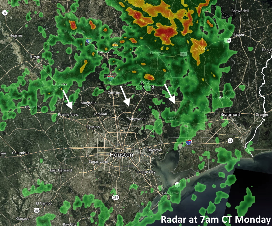
I feel like Houston is standing on the edge of the abyss this morning. We’ve got one more day of partly sunny weather with a moderate chance of rain before high pressure settles in. And by settle in, I mean builds over the region and dominates our weather in one of those classic summertime ridges that pushes up temperatures and drives away precipitation. Rain chances are not particularly great today, but they’re near zero for at least the next week after today.

Tuesday

Coastal areas should see some scattered showers this morning as higher levels of atmospheric moisture push inland, and some additional showers may push down from the north into areas such as Montgomery County and Harris County this afternoon. Still, overall chances are probably only 30 to 40 percent. Some clouds may help limit high temperatures into the low 90s. Winds will be light, out of the south at about 5 mph. With mostly cloudy skies tonight, lows probably will struggle to drop below 80 degrees for most.

Houston, thy future is hot. (Weather Bell)

Wednesday and Thursday

We’ll see building high pressure over the region, but temperatures won’t reach exceptional levels just yet. These days should be mostly sunny, with highs in the mid-90s, and south winds at 5 to 10 mph.

Friday, Saturday and Sunday

Hot and sunny. Highs will range from the upper 90s to 100 degrees. Lows will offer scant relief, falling into the low 80s along the coast, and upper 70s inland. Please take care outside during the warmest parts of the day.

Next week

This pattern appears unlikely to change before at least Tuesday or Wednesday of next week, and our next chance at any semblance of precipitation is unlikely to occur before around the July 16-18 time frame. Hot and sunny are your bywords for Houston’s weather now.


A brief reprieve before more heat returns to Houston

For the first time in more than a week, Houston’s radar is filling up with light to moderate rain showers this morning. The region will see a reasonable chance of rain today and Tuesday before decreasing chances by mid-week. After that the heat will return in force, with highs in the upper 90s to 100 degrees by the coming weekend. Houston has yet to hit the century mark in temperatures in 2020, but that could change by Saturday or Sunday.

Houston radar at 7am CT on Monday. (kktv.com)

Monday

A combination of an upper-level disturbance and moist atmosphere will allow clouds to form today, and support scattered shower development, with the better chances likely along and north of Interstate 10. We don’t anticipate anything too heavy falling today, but the additional clouds should help to modulate temperatures after highs in the mid- to upper-90s over the last week. Expect highs today in the low-90s. Humidity will still be quite high, and don’t expect overnight low temperatures to fall much below 80 degrees.

Tuesday

This day will probably offer our best chance of rain for this week—and perhaps beyond. I think most areas probably will see at least light rain, with an average of about one-quarter inch of rainfall for most. A few isolated areas may see 1 inch or more of rain. Mostly cloudy skies should help hold high temperatures to about 90 degrees, but it will definitely be a steamy 90 degrees.

See full post

2020 bringing its strongest heat so far for Houston

We topped off (officially) at 97° on Thursday, tying yesterday with June 9th for the hottest day of 2020 so far. Perhaps we could make a run today for….

No matter your age or favorite music, it’s almost always the 90s in Houston.

Maybe. If not, there is a valid chance we could do it Saturday or Sunday as well. Either way, expect a hot holiday weekend, and be sure to take it easy if you’re outdoors.

Today

Look for partly to mostly sunny conditions today. Saharan dust will again provide some haze. Air quality on Thursday did get to the “unhealthy for sensitive groups” level, and it may do so again today, so if you’ve been irritated by the recent dust events or have any respiratory ailments, today may bother you once again. High temperatures should aim for the mid- to upper-90s once more with plenty of humidity. Heat index values topped off around 105° yesterday. We should see similar to perhaps slightly lower peak heat index values today.

Heat index values should top off around 101° to 104° later this afternoon. (Weather Bell)

Rain chances aren’t zero, but they’re low for most of the area most of the day. We will watch some storms in Louisiana later this afternoon that will ride west into Texas this evening. If they can survive the trip, you may see a downpour or have a brief gusty thunderstorm east of I-45 after about 4 or 5 P.M. or so before the storms dissipate. This is a fairly low possibility.

Weekend

For the holiday weekend it will be hot. Both Saturday and Sunday should again see highs in the mid- to upper-90s and lows in the 70s. Humidity is going to creep upward this weekend, so look for peak heat index values around 105°, give or take a couple degrees on both days. Saharan dust may linger a bit, but it will slowly dissipate this weekend.

How about rain? Well, a trough and upper low look to setup shop over Mississippi and Alabama this weekend. Storms on the western periphery of that setup could graze eastern areas. This would be primarily a story for Liberty & Chambers Counties, if not mainly toward Beaumont. So a few heavy downpours are possible east of Houston. Areas to the north (Walker, Montgomery, and San Jacinto Counties) may also get grazed by some storms at times as well this weekend, particularly Sunday morning. For Houston and points south and west, your best shot at storms may be Sunday, and as it stands this morning, that’s a low probability. Either way, no significant issues are expected this weekend.

Next week

Look for scattered showers and thunderstorms on Monday and especially Tuesday. Not everyone will see rain, but it will be our area’s best shot at storms since last week, so hopefully we can participate. By Wednesday, high pressure begins to reload over Texas, building toward the weekend. We will likely be back to hot and mostly dry by the end of next week, with daytime highs back in the 95 to 97 degree range, if not hotter.

Enjoy the holiday weekend, and please stay safe.

For the July Fourth weekend: Fireworks in the skies, heat at the surface

Here comes the heat. With high pressure in the vicinity of Houston, we’re heading into a classic heat pattern for the region during summer. It can get hotter than this—I don’t think the region will see much 100-degree weather this time—but the combination of heat and humidity will be stultifying during the midday hours.

Thursday and Friday

These two days will be similar, so there’s no reason to separate them out. Both will see lots of sunshine by the late morning hours and throughout the day. Expect high temperatures to reach the mid- to upper-90s, with lows falling into the upper 70s for most areas except the coast. Light winds, out of the south at about 5 mph, will not provide much relief.

High temperatures on July 4th look hot! (Pivotal Weather)

Independence Day

Conditions won’t change much on July Fourth. We may see a few clouds, and there will be some slight rain chances to the east of Interstate 45. But for most of us, conditions will remain hot and sunny, with highs likely in the upper 90s.

Sunday through Tuesday

It looks like an upper-level low pressure system will now set up to the east of Houston, over the Gulf of Mexico, and so the best rain chances likely will set up for the eastern half of the metro area early next week. Confidence remains low—but if you live in a place like Katy I would not expect much rain, whereas if you’re in Baytown 0.5 to 1 inch may be in the cards. In any case, a few more clouds should take a bit of the edge off of temperatures for a few days.

After this, high pressure should again build over the region, and the second half of next week looks quite hot. Summer, y’all!