As Laura tracks east, Houston’s biggest issue tonight may be power outages

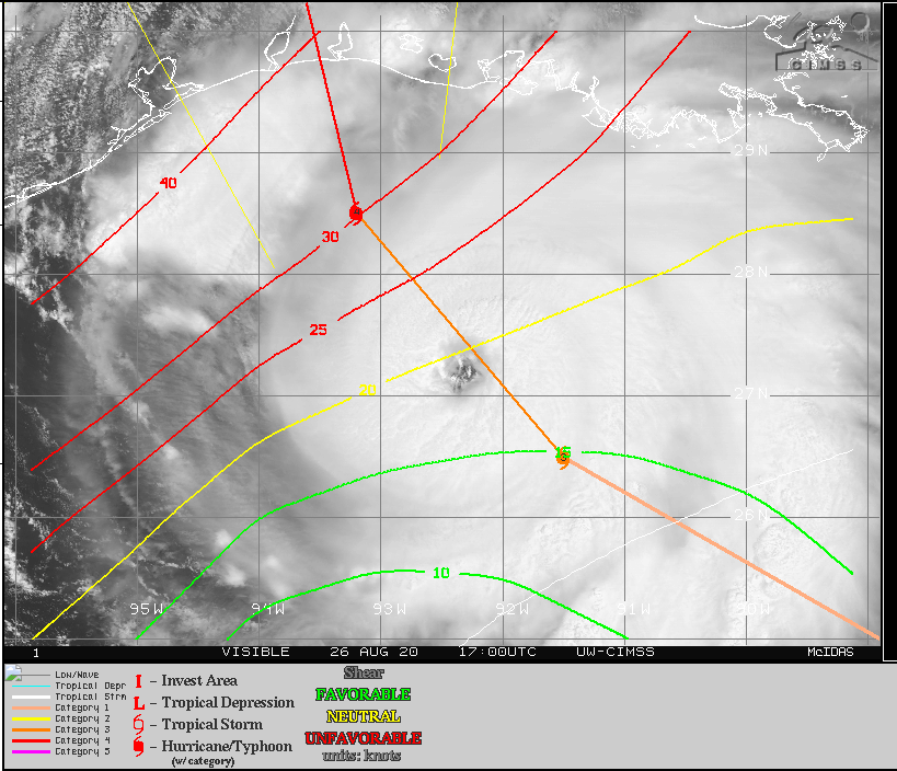
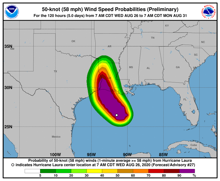
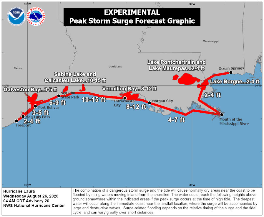
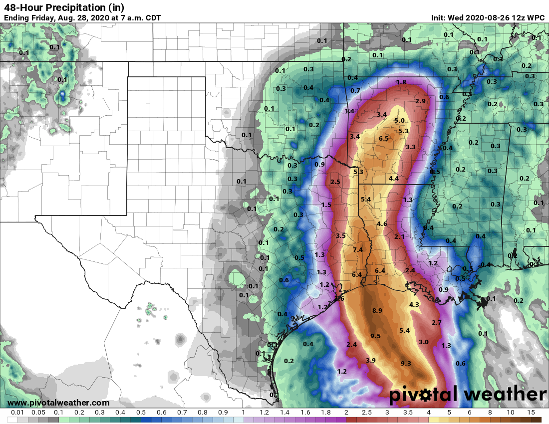
Hurricane Laura has rapidly intensified today, with 145-mph winds. Matt’s post from this afternoon has the storm’s effects pretty well covered for both Houston, Beaumont, and points east. This is an extremely dangerous storm and will prove especially punishing for western Louisiana.

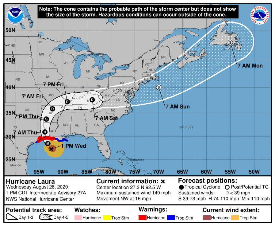
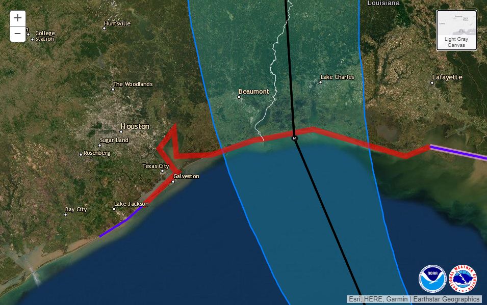
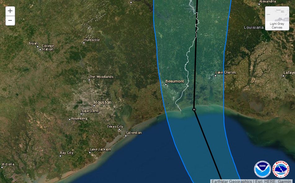
Below you’ll find the National Hurricane Center’s 4 pm CT track update. The track line remains the same, but the cone has moved further away from Houston as it has shrunk. There is high confidence in this forecast track. Laura is turning. It will continue to turn.

4pm CT Wednesday track for Hurricane Laura. (National Hurricane Center)

Power outages

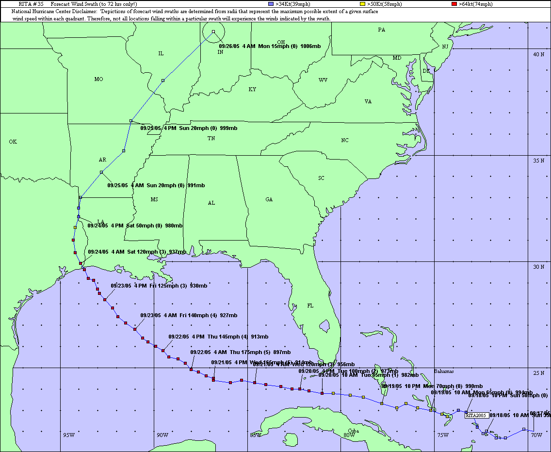
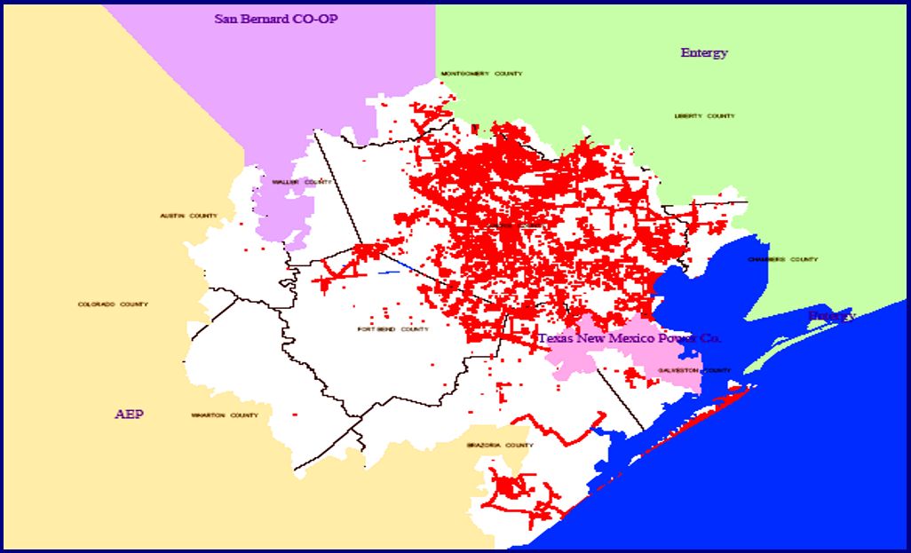
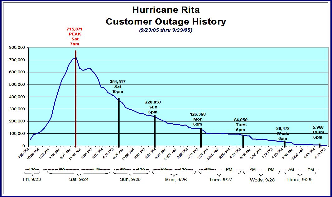
We continue to think the main issue tonight in the Houston area will be power outages due to localized, strong wind gusts that may reach 50 or even 60 mph. Sustained winds will be lower. Our best comparison for this event is Hurricane Rita. According to its financial documents, CenterPoint Energy had 1.9 million customers in 2005, at the time of Rita’s landfall. After Rita, the company reported that 715,000 customers lost power in its greater Houston service area, about 38 percent of customers. This map shows that most of those losses were on Galveston Island and clustered in the eastern half of its service area, as you would suspect.

CenterPoint service area outages immediately after Hurricane Rita. (CNP)

About half of those customers had service restored by 10pm that night, and more than 80 percent had service back by Monday evening, about 2.5 days after the storm’s passage. Nearly all customers had service back within five days.

CenterPoint restoration efforts after Rita. (CNP)

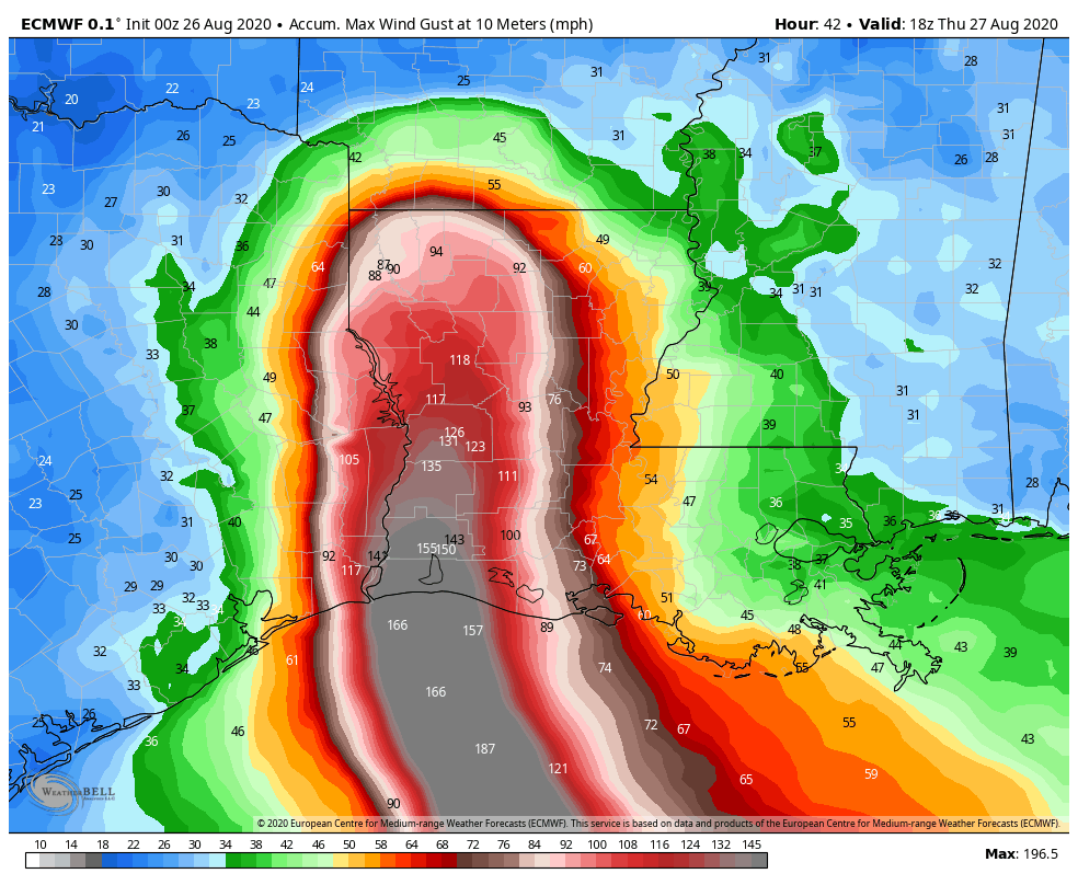
CenterPoint serves about 2.5 million customers in the region now. We don’t think outages will be as severe tonight for a couple of reasons. Although Laura is likely to be stronger than Rita at landfall, it should also be further east than that storm, and also has a smaller field of tropical storm force winds, about 175 miles compared to 205 miles for Rita. So we think there will be fewer gusts in the region, and the wind effects should be shorter lived as Laura continues to scoot along.

Additionally, after Hurricane Ike, CenterPoint began a program to “harden the system” within 35 miles of the Gulf Coast, and this involves changing wooden structures to concrete and steel. However, most of the electricity distribution system is still about 95 percent wood. In any case, it can’t hurt to charge your phone this evening, especially if you live east of Interstate 45, or close to the coast.

Our next post will come no later than 8:30 pm CT.

Laura, now a category 4 hurricane, will be a catastrophic storm for western Louisiana

POSTED AT 2 PM CT WEDNESDAY: Good afternoon. Hurricane Laura has continued strengthening in the Gulf of Mexico all day so far, showing no signs of slowing. It is now up to category 4 intensity, with maximum sustained winds of 140 mph.

Could Laura achieve category 5 status before landfall? It’s possible, as there are no signs of strengthening slowing down as of this writing (pressures keep falling). Laura is expected to come ashore below its peak intensity. It may feel the effects of some wind shear, shown in red on this map below.

Wind shear is expected to increase as Laura approaches the Gulf Coast, which may aid in slowing down the intensity a bit at landfall. (University of Wisconsin CIMSS)

That shear is moving with Laura to the north, so it may not help as much as you’d otherwise hope. More likely, Laura could experience what is known as an “eyewall replacement cycle” before landfall; basically a way for the storm to reorganize itself. When that happens, a drop in intensity usually occurs, sometimes substantial. We hope this happens right before landfall, which would allow Laura to come in on the decline, rather than at maximum intensity. Unfortunately, this aspect of the forecast is difficult to predict and we are really only relying on hope at this point. It’s possible Laura could just continue strengthening right up to landfall, similar to what Hurricane Michael did 2 years ago near Panama City, FL, though as a colleague of mine pointed out in a conversation earlier, the coastal topography of the Gulf here is much more shallow than off Florida. Shallow water can be more easily churned up and help to reduce the fuel available for hurricanes to feed off of. Whatever it is at landfall doesn’t much matter at this point, as it will still likely be bad.

Laura is moving northwest at 16 mph, which is blazing fast for this part of the Gulf. For folks in Houston, it’s important to know that Laura is doing what is expected, and “the turn” is underway. It’s not “if” or “when.” It “is” happening, and thankfully in the world of 21st century meteorology we can say that with authority. We will not be hit too hard here by this storm. Laura is expected to make landfall on the Cameron Parish side of the Texas/Louisiana border as a category 4 hurricane tonight perhaps around or just before midnight.

Laura will make landfall near or east of the Texas/Louisiana border tonight, likely as a category 4 hurricane. (NOAA)


Let’s walk you through the expected wind and surge impacts at this time.

Houston area: West of I-45 (The Woodlands, Katy, Cypress, Sugar Land, etc.)

Periods of showers and thunderstorms possible to likely tonight. Impacts peak between 9 PM and 3 AM with winds of 15 to 25 mph and gusts as high as 30 mph or so.

Houston area: East of I-45, north of I-10 (Kingwood, Humble, Crosby, etc.)
Impacts peak between 9 PM and 4 AM with winds of 15 to 25 mph. Gusts will peak around 35 mph or so.

Areas around or just inland from Galveston & Trinity Bays (Bay Area communities, Texas City, League City, Baytown, etc.)
Impacts peak between 8 PM and 4 AM with sustained winds of 25 to 35 mph and gusts of 40 to 50 mph, highest south, lowest north. Surge of 1 to 3 feet, though northerly/northwesterly winds may push water to the south toward Galveston

Galveston & Bolivar
Impacts peak between 8 PM and 4 AM with sustained winds of 30 to 40 mph and gusts of 50 to 60 mph, or a bit higher possible. Storm surge on Galveston Island is expected to be on the order of 1 to 4 feet, with the bay side experiencing surge as well. Storm surge on the Bolivar Peninsula may be as high as 4 to 5 feet.

Beaumont-Port Arthur-Orange area
Impacts peak between Midnight and 5 AM with sustained winds of 75 to 90 mph and gusts of 95 to 110 mph. Surge of 10 to 15 feet into Sabine Lake.

Lake Charles area
Impacts peak between midnight and 6 AM with sustained winds of 75 to 100 mph and gusts of 95 to 120 mph. Storm surge of 15 to 20 feet into Calcasieu Lake.

Rainfall
Just to further put you at ease, the total rainfall through tomorrow in the Houston area is expected to be 1 to 2 inches total. Many places will likely see less than this. A few to the south and east may see a bit more.

Laura’s passage will not be a flooding event in Houston. (Weather Bell)

But in this case, flooding, other than some nuisance street flooding is not expected. On Friday, we may see a slightly better chance of some heavier rain as modeling has been in agreement on a better signal for storm chances from a trailing band feeding into Laura’s remnants over the Mississippi Valley then. Something we’ll check into more closely tomorrow.

So again, just to summarize, Laura is moving northwest and will turn more north-northwest this evening, likely making landfall on the Louisiana coast, well east of Houston, as a major hurricane. Eric will have our next post no later than 5:30 PM CT.

Laura still intensifying, tracking toward southwestern Louisiana

POSTED AT 10:30 AM CT WEDNESDAY: Just a quick, mid-morning update to share the latest information from the National Hurricane Center, and drill down a little bit more into what you should expect tonight, and when, in the Houston area. The storm has unfortunately continued to intensify, now up to 125 mph, and the hurricane center predicts Laura will come ashore as an extremely powerful hurricane with 145 mph winds tonight just east of the Texas-Louisiana border. Forecasters had this sober message for coastal residents near the landfalling storm: “Unsurvivable storm surge with large and destructive waves will cause catastrophic damage from Sea Rim State Park, Texas, to Intracoastal City, Louisiana, including Calcasieu and Sabine Lakes. This surge could penetrate up to 30 miles inland.”

Updated cone and track forecast at 10am CT Wednesday. (National Hurricane Center)

Closer to home, right along the coast, the biggest impact will be storm surge. However, forecasters have backed off their expectations for the Galveston area, slightly, with 2 to 4 feet of surge now anticipated. We still expect low-lying areas on Galveston Island and Bolivar Peninsula to be inundated with water for several hours tonight. Storm surge will get incrementally worse up the Texas coast, and reach its peak east of Laura’s landfall, in Louisiana.

For everyone else, it’s going to be almost all about the wind. Some areas of town are already seeing breezy winds from the northeast, with recent gusts of about 20 mph reported at Hobby Airport. These winds will build this afternoon and evening and likely peak from about 9 pm through 3 am. I anticipate the potential for Tropical Storm-force wind gusts for at least the eastern half of the metro area, with the greatest risk right along the coast. (The National Hurricane Center estimates there is a 6 percent chance of hurricane-force winds in Galveston, and a 21 percent chance in High Island).

Probability of sustained winds of 58 mph or greater due to Laura. (National Hurricane Center)

This morning I mentioned the widespread outages during Hurricane Rita for the Houston metro area. I think that remains the biggest potential for disruption tonight, and you ought to be prepared for at least a short outage. But quite frankly, the storm is now tracking slightly east of where Hurricane Rita came ashore in 2005, and will be turning away from Houston. Yes, Laura is more powerful, but we are nonetheless getting further from its core of stronger winds. This eastward movement may also spare Beaumont and Port Arthur from the storm’s very worst effects, but it is still going to be most dicey. We hope to have better information on this later today.

In terms of rainfall we have no real concerns. There may be some briefly heavy downpours, but the region’s bayous are dry. Accumulations of less than 1 inch are likely west of Interstate 45, with 1 to 4 inches possible on the east side of town, increasing as one nears Beaumont.

Rains and winds from Laura should be rapidly moving away from the Houston area by Thursday morning. Rain chances will linger through the remainder of the week, but it really should be nothing to worry about.

Our next update will come no later than 2:30pm CT.


Confidence high in Laura landfall near Texas-Louisiana border tonight

POSTED AT 6:50 AM CT WEDNESDAY: Good morning. Hurricane Laura has really intensified overnight, and at sunrise this morning it is a Category 3 hurricane with 115 mph winds. It may peak at 130 mph later today before landfall tonight.

Houston now lies well out of the National Hurricane Center forecast cone (see map below) and it is now clear the Houston-Galveston metro area will escape the worst of what is a powerful Hurricane Laura. We are still going to monitor this storm closely, and we will definitely see some inclement weather in our region later today and tonight—but nothing like the Beaumont, Port Arthur, and Southwestern Louisiana areas will experience as Laura makes landfall near the border between Texas and Louisiana around midnight. This has been a very, very close call for Houston.

Here is a high-resolution view of the 4am forecast track and “cone” for Laura. (National Hurricane Center)

Hurricane Rita

It seems increasingly evident that Hurricane Rita will offer a useful guide for what to expect from Laura. Rita made landfall just east of the Texas-Louisiana border on September 24, 2005, as a Category 3 hurricane with 115-mph winds. This is near the expected landfall strength of Laura (present forecast is 120 or 130 mph). It looks like Laura may track slightly east of Rita’s path inland, but the 15-year-old storm provides a strikingly similar analog.

Track of Rita. Note its shocking intensity (175 mph) just two days before landfall. (NOAA)

So what were the effects of Rita in Houston? This National Weather Service report provides information on wind gusts and rainfall totals from across the region. Winds were the most striking effect. Peak gusts just above 60 mph were recorded at Bush Intercontinental Airport and Galveston Island, with sustained winds of 45 mph. Most of the region briefly saw gusts in the 50s. This was enough to knock out some power on Galveston Island. So I think for Houston, tonight, we should expect to see downed trees and sporadic to widespread power outages. Damages from Rita were estimated at $90 million in Harris County, most due to food losses during outages.

Conditions today and tonight

Now that we finally have a solid handle on Laura’s track and intensity, we can speak with some reasonable confidence about weather as the storm makes landfall around midnight tonight, or shortly thereafter.

Winds

Areas east of Interstate 45 in Houston have about a 50 percent chance of seeing tropical storm-force winds, likely beginning around sunset or a few hours afterward. Areas such as Galveston Bay, Chambers County, and Bolivar Peninsula will see higher gusts. This forecast map, from the European model, provides a reasonable estimate of “peak” wind gusts that can be expected tonight at a level of 30 feet off the ground. Winds at the surface will be about 10 percent less. Under this forecast, Beaumont and Port Arthur would likely miss the storm’s most catastrophic winds, but it’s still going to be nasty, and at this point it’s too close to call. A destructive wind path will continue well inland along Laura’s track.

European model forecast for peak wind gusts from Hurricane Laura. (Weather Bell)

Storm surge

Surge is another major concern as Laura grows larger and more powerful over the Northwest Gulf of Mexico. The following map from the National Hurricane Center estimates the level water could reach above normal levels at high tide.

Storm surge forecast for Hurricane Laura. (National Hurricane Center)

Rainfall

Scattered showers and thunderstorms will likely move into the area from the southeast this morning, and will then spread over the region later today and tonight. Here is the latest estimate for rainfall totals over the next 48 hours.

Rain accumulation forecast for between now and Friday morning. (Pivotal Weather)

Note to readers

We have received so many kind e-mails, comments here, on Facebook, on Twitter and elsewhere that Matt and I cannot reply to them all, at least not in the midst of a frenetic forecasting period like this. But know that we do deeply appreciate you, our readers. Thanks to word of mouth, almost exclusively, we have grown rapidly since starting Space City Weather in late 2015. On Wednesday, alone, we had 1.6 million page views and more than 520,000 visitors to the site. This is more than Matt and I could have hoped, and we are humbled by your appreciation. Really, we are just two nerds with a passion for weather. We’re glad to be able to share that with you, and help in times of crisis, with the support of Reliant. Our philosophy will never change—we’re just trying to make the best possible forecasts amidst the uncertainty. We love the Houston region, warts and all, and it is our pleasure to be able to give something back.

Our next post will come at 10:30am CT.