A tricky forecast for rain chances this weekend in Houston

Good morning. It was quite a wet afternoon and evening on Thursday, though outside of a few areas of localized flooding, the rain didn’t cause too much heartburn. Except in Deer Park, where it looks like a microburst (strong, straight-line winds) inflicted some damage in the area around the high school.

With continued chances at rain, we will continue to carry our Stage 1 Flood Alert into at least Saturday.

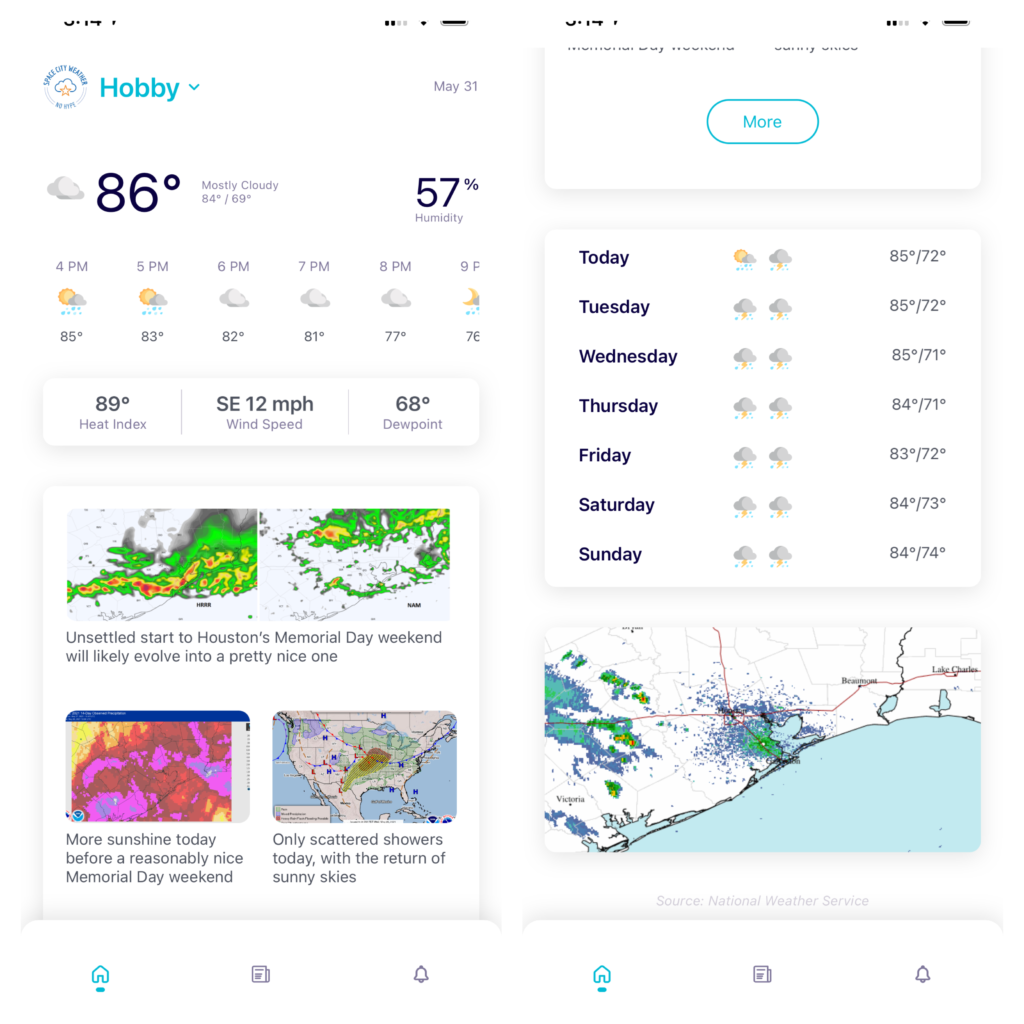
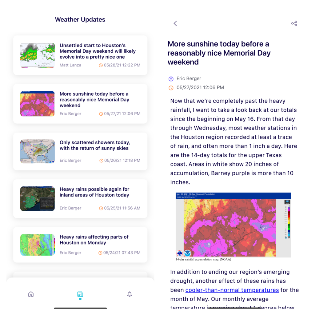
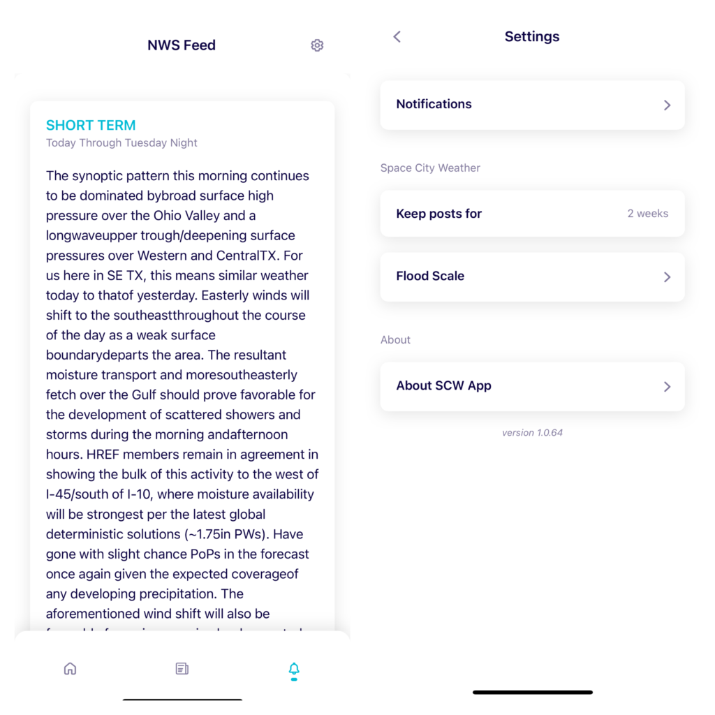
Before we jump into the forecast details, in case you missed it, Space City Weather now as an app available for both Android and Apple users! You can check out Dwight Silverman’s introductory post for more details. And please, if you notice any bugs or issues, shoot us an email at [email protected]. We’ve gotten lots of feedback so far, and we will do our best to address your reports in a timely manner! I just want to personally thank Dwight, Eric, and especially Hussain Abbasi for getting us here. It’s just a really good, clean, functional app, and I’m thrilled we can share it with you all.

Alright, let’s get into this somewhat tricky forecast.

Today

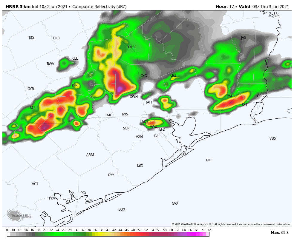
Radar this morning shows that most heavy rain has pushed offshore south and east of Houston. There are some scattered showers, including a few downpours in spots west of Houston.

Morning radar shows mostly nuisance showers west of the city with organized rains offshore. (RadarScope)

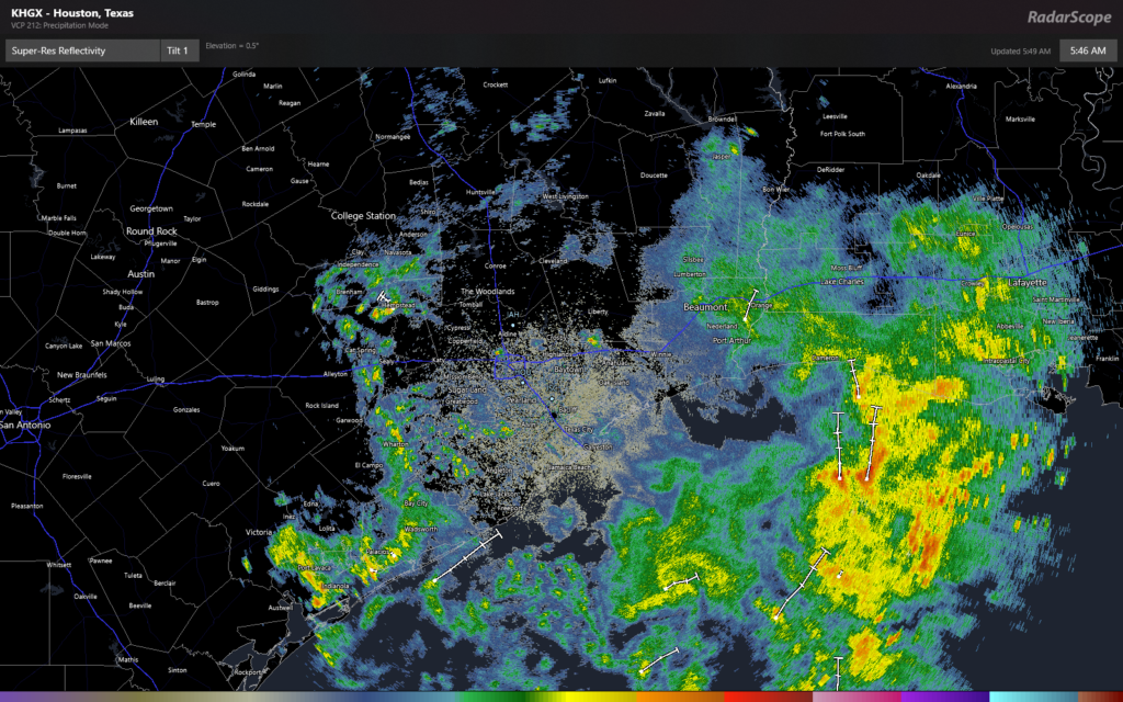
Storms should get going again along the sea breeze this afternoon, as it pushes inland from the Gulf. There’s a certain degree of randomness to these things. Yesterday’s rain began on the sea breeze and then transitioned to a widespread steady but lighter rain as a disturbance coming out of central Texas intercepted the sea breeze boundary. Today may be more hit and miss, but risk for areas of heavy rain will continue. Atmospheric moisture remains fully loaded, but instability, which we need to really get things popping, looks to be down a bit today. Expect at least some rain and some pockets of heavier rain, but at this time, we don’t expect widespread heavy rain today. We will let you know if that expectation changes.

Tonight through Sunday

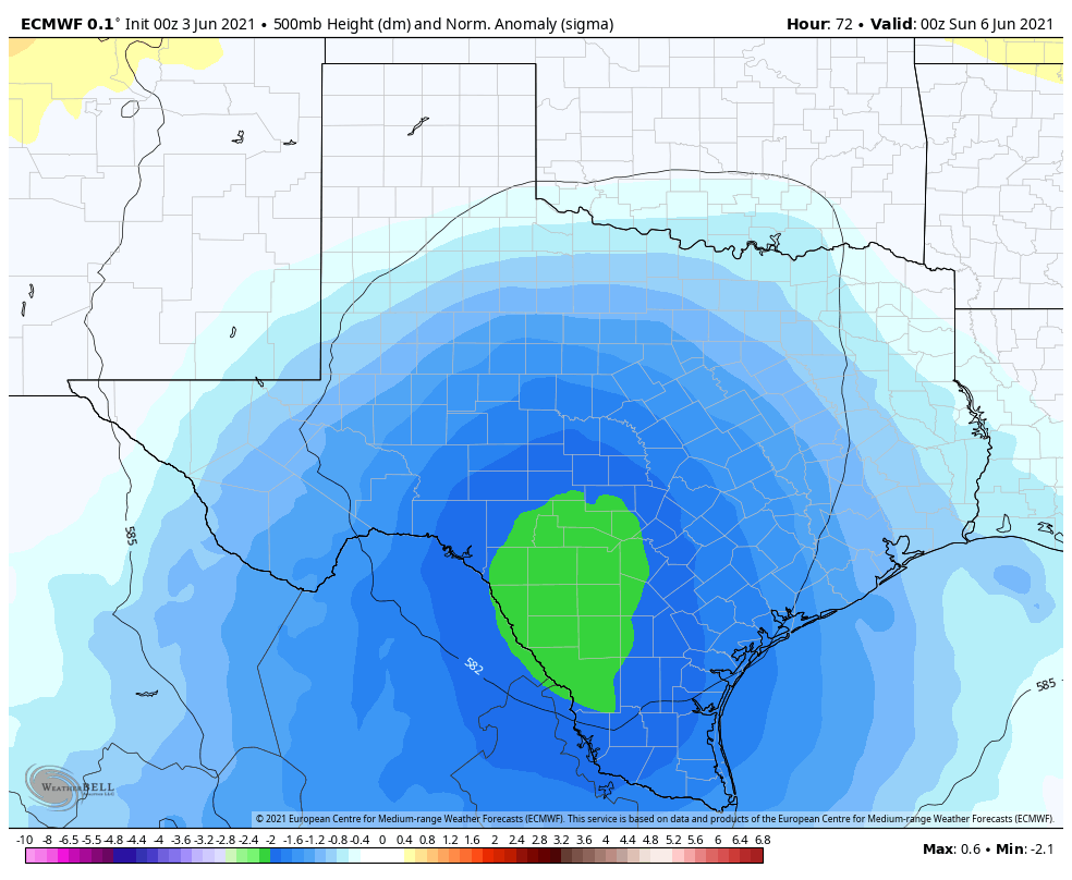
We supposedly enter the heart of this rainy period tonight and tomorrow as the upper low ejecting out of Central Texas meanders north and east past our area. As this happens, we may, for a time, maximize the ingredients necessary for periods of rain and storms, and this is where we will watch for more widespread heavy rainfall chances and more notable street flooding potentially. I say “supposedly,” because there’s been a shift in modeling today, which favors areas east of the Houston area, mostly in Louisiana for the heaviest rain risk. Upper lows are notoriously tough to forecast and little changes like this can lead to big expectation changes. We will keep you posted through the weekend.

So between tonight and Sunday, don’t expect it to rain the entire time, but there will be periods of showers, storms, and locally heavy rainfall. We think Saturday may have the highest chances for that to happen, with perhaps the worst of the action shifting out of our area by as early as Saturday afternoon and staying east of us Sunday. That doesn’t mean a dry weekend, but it does perhaps allow for more frequent breaks in the rain. Most outdoor plans this weekend will likely need to be either a true game time decision or postponed if you would rather not deal with the hassle.

Taking the glass half full approach (depending on your point of view, of course): We typically start to ramp up into summer heat around now, but there is absolutely no heat to be found thanks to the clouds and rain. Highs this weekend will generally be in the low-80s with lows in the 70s.

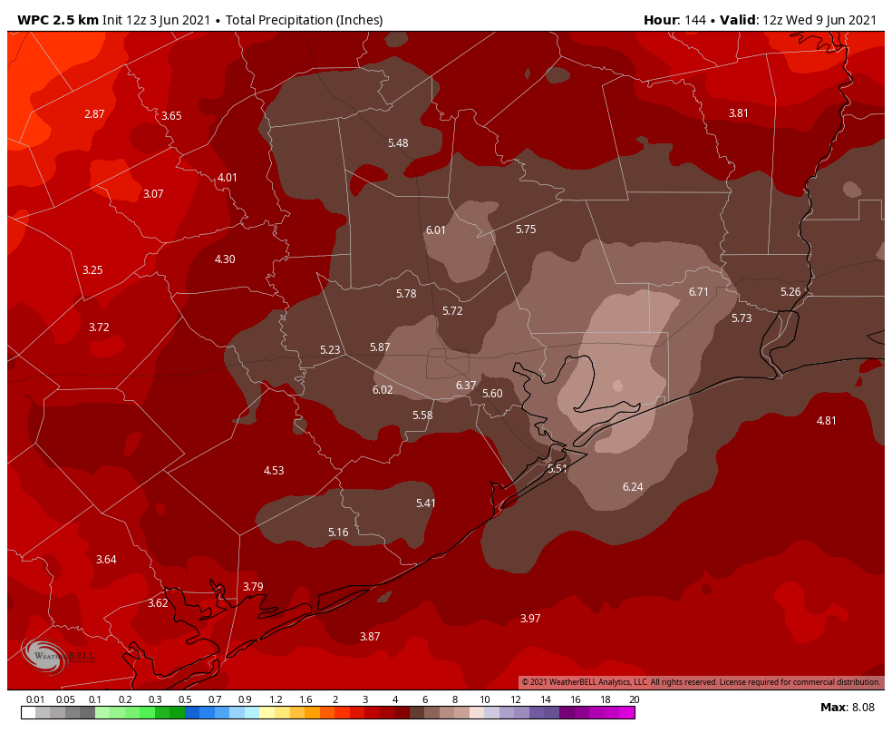
How much more rain? Between now and Sunday evening, we expect that most areas will see another inch or two on average.

Another inch or two of rain is likely on average between now and Sunday evening, though some areas will see more and others less. (Weather Bell)

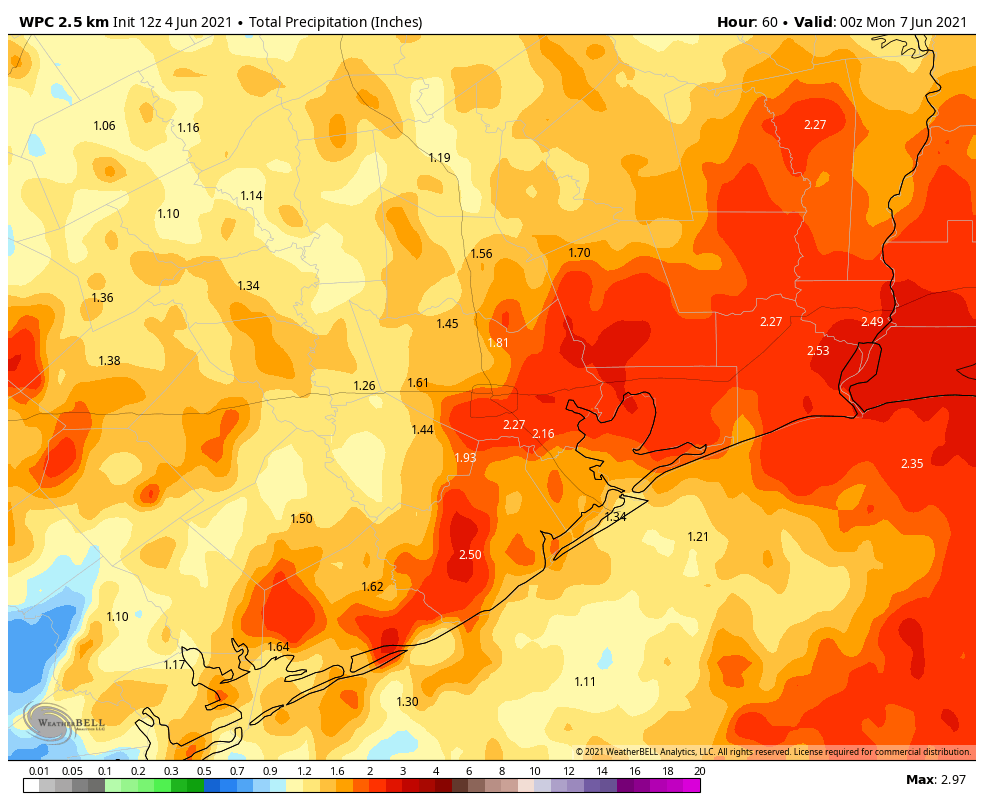
Some places will almost certainly see more, while some other locales may see a bit less. Again, the Stage 1 Flood alert we have posted is meant to cover for those handful of locations that see mostly nuisance street flooding like we saw yesterday.
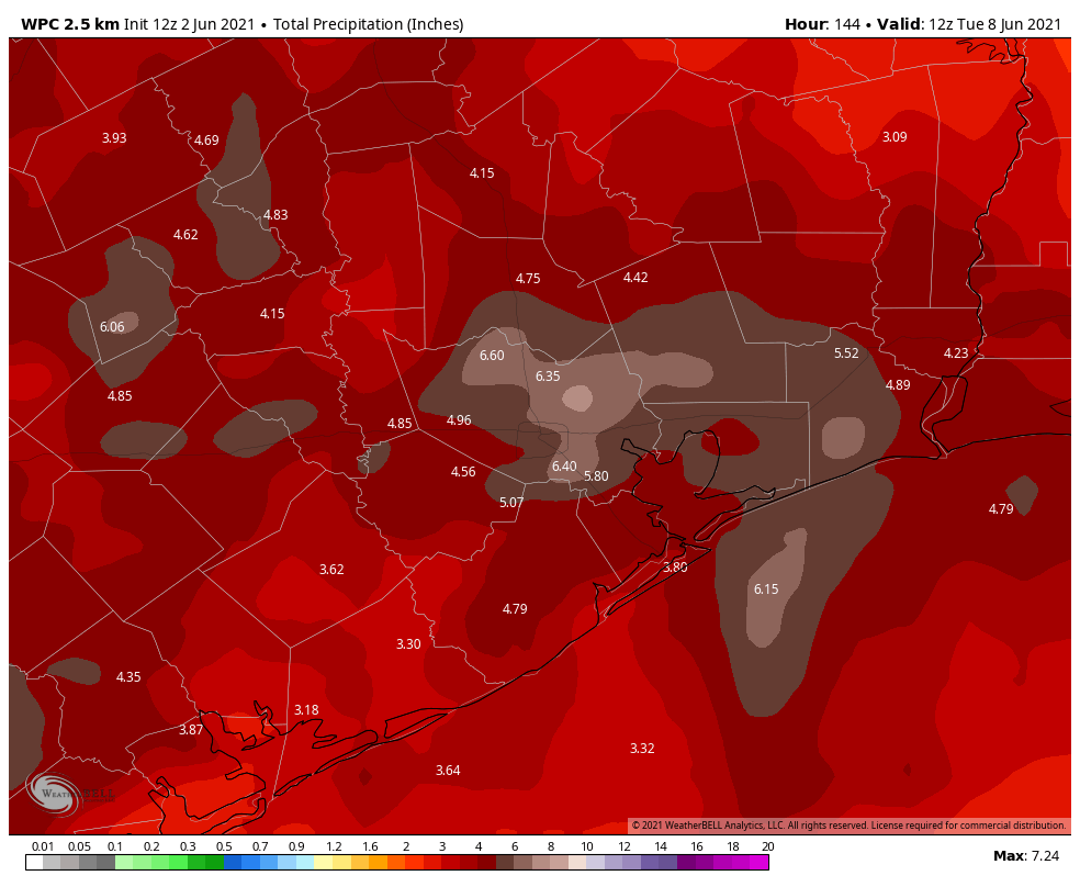
Next week

I fully expect more rounds of showers and thunderstorms to start next week. Monday and Tuesday look like they will have the highest odds of wet weather. But I don’t see a truly dry day area-wide before next Wednesday at the earliest.

It’s finally here! Introducing the Space City Weather app

I’m very excited to announce today that our brand new app is available for download immediately. Dwight Silverman, who wrote this introductory post, and the developer, Hussain Abbasi, worked through the entirety of Memorial Day weekend to complete this app for the beginning of the Atlantic hurricane season. We strived to deliver a product that is simple, powerful, and just a tad whimsical. I hope you like it. Here’s Dwight with more …

The Space City Weather app was designed to be easy to use and focus on the content available from the site, while quickly providing you with the weather information you need at a glance. It’s also intensely Houston-centric – which is why, for example, you’ll find humidity sharing equal billing with the current temperature atop the home screen.

Because if you live in Houston, it’s always about the humidity.

The app is divided into three simple screens. At the top of the initial screen are current conditions, the hourly forecast and the most-recent Space City Weather posts. As you scroll down, you’ll see a seven-day forecast and the current radar from the National Weather Service.

Because the metro Houston area is so vast, you can choose from one of five zones closest to you for forecasts and conditions. Just tap the city name at the top to switch between Houston (Bush Intercontinental Airport), Hobby Airport, Conroe, Galveston and Katy. You’ll have to do this manually, because we’re not tracking your location. (Hey, if you’re making your third trip to Shipley’s today, that’s your business, not ours.)

Tapping the middle icon at the bottom takes you to an index of the past week’s SCW posts. Tapping on any of those—including the posts featured on the first screen—will let you read them in their entirety in the app.

The third screen is for those who want easy access to weather discussions from the National Weather Service, which are written by forecasters at the agency’s office in League City. We think this provides a nice supplement to Space City Weather, and offers a slightly more technical analysis of the forecast. It updates several times a day. In this feed you’ll get the short and long form discussions, as well as specialty reports for marine and aviation interests. When the NWS issues weather alerts, those appear at the top of this screen, based on which zone you set on the home screen.

At the top right of the NWS screen is a gear icon that takes you to settings, including controls for which push notifications you’ll receive. Now, there’s no more need to check your email or Facebook to find out when we’ve updated during a storm. You can also control how many posts are retained, and learn more about the SCW Flood Scale.

Our app doesn’t try to replace detailed, general weather or radar apps you already may have on your mobile device. We’re not a huge business with resources for that. So the app brings you the weather you need to know specific to the Houston area, as well as Eric and Matt’s expert insights.

One other thing we want to emphasize: There are no ads, no in-app purchases, no tracking or hoovering of your personal information. We gather diagnostic data to make sure the app is working properly, and that’s it. We respect your privacy.

It’s available for both Android and iOS devices, and the two are functionally identical. We’d like to thank Hussain Abbasi, who developed the app for us with a grant from Arnold Ventures, and our ongoing sponsorship by Reliant. Thanks to their support, and your generous donations during our annual fundraiser, the app is free, and always will be.

This is version 1.0 of this app, and we welcome your suggestions for updates and improvements. As you make suggestions please think local and simple.

And if you spot any bugs (yes, we know there is one with the radar on iOS right now), please report them to [email protected]. We may not be able to respond to each report, but we’ll take a close look at them all.

As always, thanks for being part of the SCW community, and enjoy the app!

Heavy rains still expected this weekend, likely to affect roadways

Strong showers and thunderstorms developed on Wednesday evening, quickly dropping 2 to 3 inches of rain over parts of northeast Houston, near Humble. Other areas of the city also saw briefly strong storms with incredibly loud thunder. We still anticipate this heavy rainfall becoming more widespread this weekend, and due to the potential for street flooding we remain under a Stage 1 flood alert for the entire area.

Thursday

Today will be similar to Wednesday in that the daytime should see a mix of sunshine and clouds, allowing high temperatures to get into the upper 80s. As the temperature rises, we’ll see an increase in rain chances this afternoon. Rains will likely start somewhere near or just south of the Interstate 10 corridor, and then slowly lift north. I suspect a few areas will again see bullseyes of 2 to 3 inches of rain today, with most of the area seeing significantly less. Rain chances get lower after sunset.

Friday

At this point, it looks like conditions will favor more widespread rainfall on Friday, with 0.5 to 1.5 inches for much of the region, and higher isolated totals. Friday begins the period of biggest concern for us with these rains, and it will run through about Monday. As is typical with this kind of system, it can be difficult to predict exactly when and where the heaviest rains are going to fall even a few hours beforehand.

So what is this system? Essentially, a slow-moving upper-level low will move across the mountains of northern Mexico into southern Texas on Friday. Then it will meander across the state, with disturbances rotating counter-clockwise around its base. As it does so, the upper-level low and its associated disturbances will draw the Gulf of Mexico’s ample moisture into the coast, and this will set up a wet pattern that we won’t break out of for several days.

That green blob is the upper-level low on Saturday night, sort of wobbling over south Texas. (Weather Bell)

Saturday, Sunday, and Monday

This setup will generate periods of heavy rainfall along the Texas coast this weekend and into Monday. With access to the Gulf moisture, these storms will be capable of producing rainfall rates of 1 to 3 inches per hour, and this quickly backs up streets. It looks like the peak of activity will come from Saturday afternoon through Sunday morning, but again, confidence with predicting specificity this far out is low. Bottom line: prepare for heavy rain this weekend. We expect widespread accumulations of 4 to 6 inches, with higher localized accumulations. Matt and I will be watching all of this closely to keep you informed.

NOAA rainfall accumulation forecast for Houston through Tuesday. (Weather Bell)

Next week

So when does this mess move on? Rain chances will start to slacken by Tuesday or Wednesday, and we think building high pressure will shut the spigot off by later in the week. Probably. Hopefully.

Looking ahead to a wet weekend for the Houston metro area

Good morning. The radar is quiet across the region, and likely will remain so this morning. However, the overall pattern remains favorable for rainfall this week, likely culminating in widespread showers and heavy rainfall on Saturday and Sunday. For this reason, we have instituted a Stage 1 flood alert that will run through the weekend. This is the lowest alert on our flood scale, and means there is the potential for nuisance street flooding.

Wednesday

Skies should be partly sunny today, and this will allow temperatures to warm into the mid- or upper-80s later on. In terms of rain, we expect a cluster of storms to approach the region from the west this afternoon. The question is how long they hold together, and whether they migrate all the way to the coast where a capping inversion should be a bit stronger. Therefore areas west of Interstate 45 and north of I-10 have the best chance for rain this evening through about midnight, and there could be some briefly heavy showers dropping an inch or two of rain over parts of the area. Rain chances fall back late tonight.

HRRR model depiction for radar at 10 pm CT Wednesday. NOTE this is just single model forecast. (Weather Bell)

Thursday

This will be another day with the potential for showers and thunderstorms to develop, with briefly heavy rain across the metro area. About half of the area will probably see some rainfall. As skies will be mostly cloudy, temperatures should remain in the mid-80s on Thursday.

Friday, Saturday, and Sunday

As an upper-level low pressure system moves closer to our region this weekend, we’ll see increasingly favorable conditions for widespread rainfall beginning Friday. As usual, the details are difficult to pin down, but these kinds of atmospheric conditions typically produce heavy rains that can quickly back up streets. If you’re thinking about weekend plans, our best guess is that the period most likely to see showers and thunderstorms will run from mid-day Saturday through Sunday morning. But rain chances will be fairly high from Friday through Sunday, and most of the area will likely see accumulations of 3 to 6 inches. Otherwise, expect partly to mostly cloudy skies, with highs in the low 80s.

NOAA rain accumulation forecast for now through Monday night. (Weather Bell)

Next week

I’d love to tell you that by Monday we’ll see plenty of sunshine, but the reality is that we’ll probably see a continuation of healthy rain chances—in the 50 percent range—through the middle of next week. The overall pattern will then likely turn drier by the end of next week, with more sunshine and temperatures likely approaching the 90s. It is June, after all.