Another windy day for Houston, though not as bad as Thursday

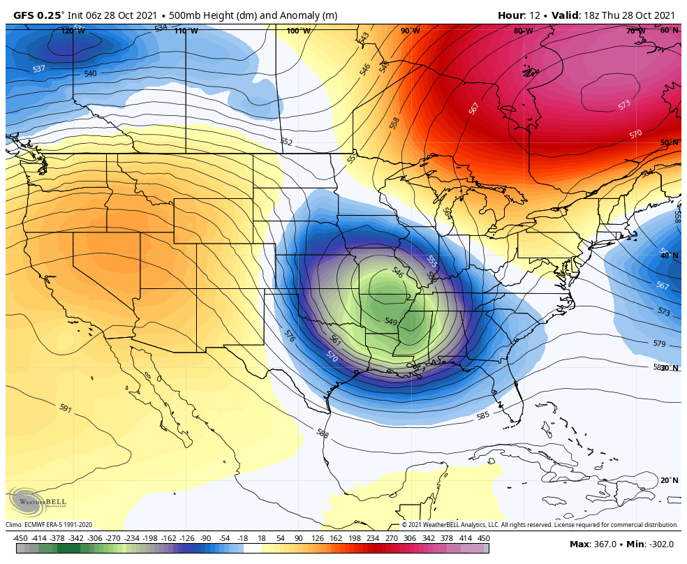
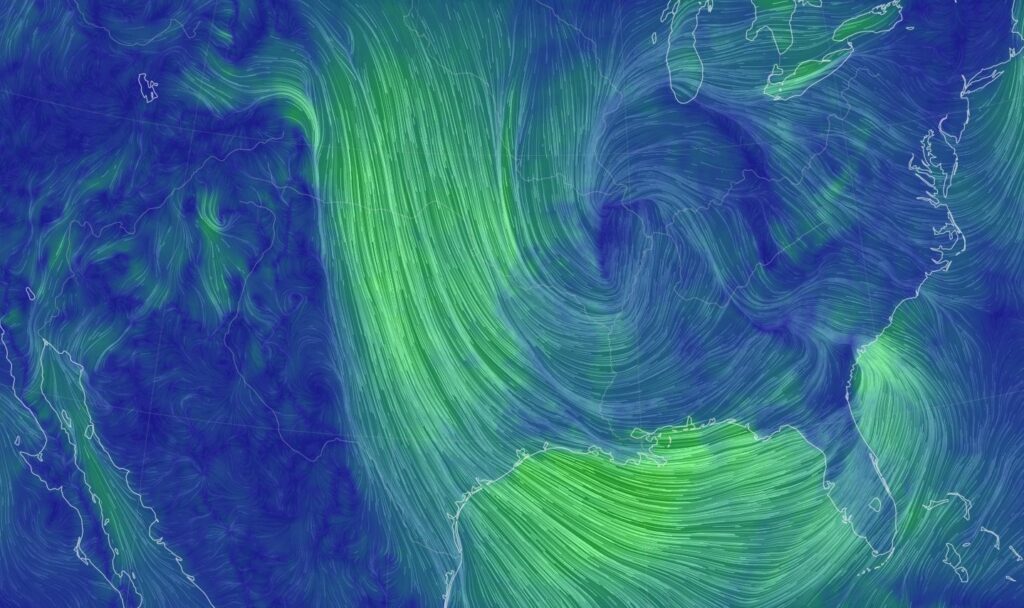
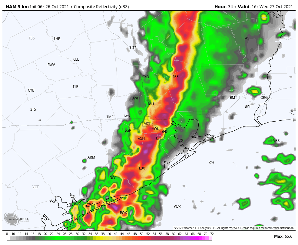
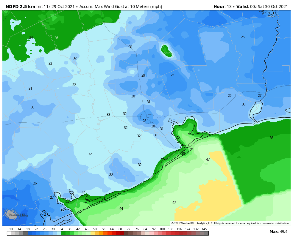
Yesterday was one of the strongest non-tropical wind events we’ve had around here in recent memory. It was both impressive and unsettling, as I can attest to nearly being taken out by a falling piece of iron on McKinney Street in downtown Houston. Winds gusted as high as 61 mph at Hobby Airport, 64 mph in Cypress, 52 mph in Pearland, and 49 mph in League City. Thousands lost power for a time due to the wind. We will continue to have windy weather today, but it should be less extreme than Thursday’s gusts. We then expect an absolutely sublime weekend of weather.

Today

If winds gusted 40 to 60 mph yesterday, they should gust more like 25 to 40 mph today. It will be something you certainly notice, but it will definitely be less than yesterday’s madness. Winds will kick up as the sun gets higher in the sky this morning, then they’ll actually begin to back off some as the afternoon wears on.

The forecast for maximum wind gusts today should be a good bit below what we experienced yesterday and be strongest along the coast. (Weather Bell)

Otherwise, expect sunshine. Highs will top off around 70 degrees or in the lower 70s. All this wind has kicked up a lot of allergens as well, so you may be sniffly or sneezy today into the weekend.
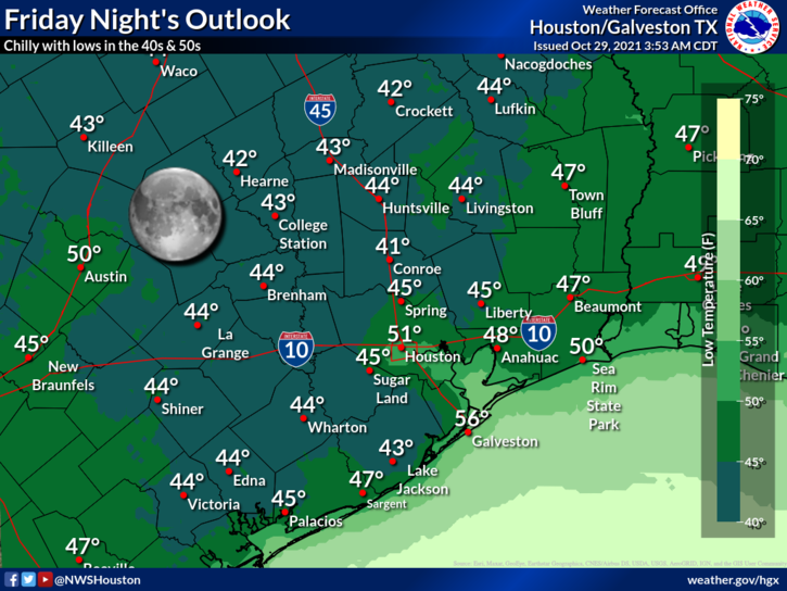
Friday night’s low temperatures may be the coolest of the season so far for many folks with widespread 40s and lower 50s. (NOAA)

Weekend

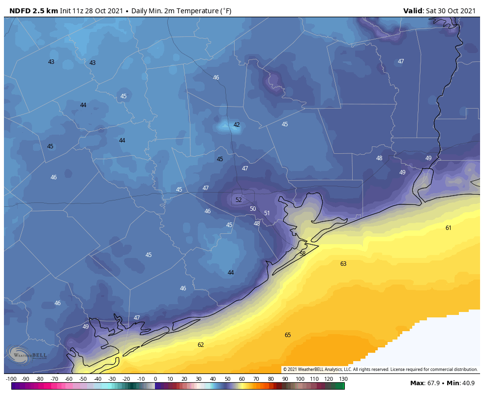
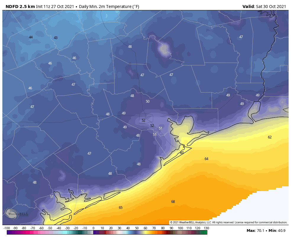
The weather this weekend looks just perfect with rampant sunshine. Winds will be light. Look for highs in the mid-70s on Saturday and upper-70s on Sunday. Morning lows will be in the 40s and 50s Saturday and Sunday, coolest inland, warmest in the city and near the coast. Officially, our coolest reading of the season was 50° back on October 17th, so we’ll see if we can match or beat that this weekend.

Trick or treating

Look for temperatures around 71° to 75° at 6 PM and 66° to 70° at 8 PM on Sunday evening. It should be clear and calm.

Astros in Atlanta

Obviously we have other important business to attend to this weekend with the Astros in Atlanta today, tomorrow, and Sunday. All 3 games should be playable. Showers will end around sunset in Atlanta this evening, with clouds and temperatures around 50° for most of the game. Winds will be out of the southeast (blowing in from right field) around 5 to 15 mph. Game 4 on Saturday should again see any showers ending. Temperatures will be in the mid-50s, with a light to moderate breeze from right to left field. Sunday looks fine, with gametime temperatures in the upper-50s, falling into the mid-50s and light northwest winds (blowing out to center field). Go ‘Stros!

Next week

Monday and Tuesday look to be very nice, though they will warm up and turn just slightly more humid. Look for highs near 80° and morning lows in the 50s and 60s. Our next front will attempt to make it here later next week.

Various models and ensemble members strongly agree on another front arriving later next week, but they disagree on both timing and how cool the air following the front will be. Much to sort out. (Weather Bell)

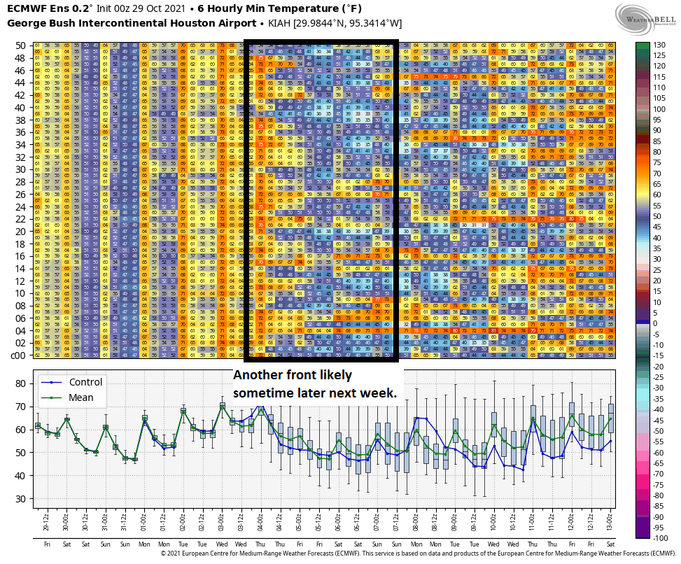
This one could come with even slightly cooler air than what we’ll see this weekend, but specific details on the exact timing and strength of the cool air remain a little fuzzy. Check back with us Monday for the latest.

Galaxy Frights, Presented by Reliant

Looking for some tricks and treats this weekend? Check out Galaxy Frights, Presented by Reliant, at Space Center Houston! You can hear from astronauts on the scariest parts of space exploration, become a mad scientist in the Pop-Up Science Labs, experience a great light display, navigate through a spooky maze and, of course, do some trick or treating! More here: https://spacecenter.org/galaxy-frights/

Here’s why the winds are going to be rather blowy on Thursday and Friday

Good morning. The cold front is through, and it’s starting to feel a lot more like fall. We’ll see a couple of breezy and cooler days before a truly sublime fall weekend. Temperatures warm a little next week before the probable arrival of another front by Wednesday or so.

Thursday

Temperatures will warm into the mid- to upper-70s today for much of the region, with sunny skies. But perhaps the bigger story will be a persistent northwesterly wind that may at times gust to 30 or 40 mph. What is driving this? Houston is caught between high pressure to our west, and the surface low—the front that crossed our region on Wednesday—off to our east. At the mid-levels of the atmosphere, the pattern looks like this:

500 mb height anomaly map. (Weather Bell)

If this map is a little confusing, simply remember that air wants to move from higher pressure to lower pressures. On Thursday, and to a lesser extent Friday, our region will be caught within a tight pressure gradient as air flows from high pressure to our west, toward lower pressure eastward. This is what the wind flow map will look like later this morning.

Wind flow map for late Thursday morning. (nullschool.net)

Winds will back off a little this evening, but the potential for gusts of about 20 mph will continue to mix air at the surface. As a result, low temperatures will likely only fall into the mid-50s for urban areas, with temperatures several degrees cooler for inland areas, and warmer along the coast.

Friday

Although the pressure gradient will ease somewhat on Friday, we’ll still see winds gusting to 20 to 30 mph during the daytime. This should be the coolest daytime, with highs perhaps reaching only the low 70s under mostly sunny skies. As winds begin to finally die down Friday evening, it will set the stage for ideal cooling conditions, and this should be the coldest night of the fall so far. Inland areas should see lows in the 40s, with the 50s everywhere else except possibly right on the coast.

Saturday morning’s low temperatures. (Weather Bell)

Saturday

This will very nearly be a perfect day, with sunny skies, highs in the mid- to upper-70s and light winds. Overnight lows should be a few degrees warmer than Friday night.

Sunday

By Sunday light winds should return from offshore, but our airmass will remain pretty dry overall. Look for highs in the upper 70s to near 80 degrees, with sunny skies. Trick-or-treating temperatures will be in the mid-70s, and it will be rather pleasant.

Next week

Dewpoints will climb into the low 60s next week, so our air will feel a little more humid as highs get back into the low 80s. But it won’t really feel summer-like. Some showers may return by mid-week ahead of what looks like our next front. This should reach the area by Wednesday or so, and although it probably won’t be as strong as the current front, it should still bring overnight lows back into the 50s. Probably.

Winter outlook

Last week, we published a winter outlook. Today, if you’re so inclined, Matt, Maria, and I will discuss this and answer some of your questions in a Facebook Live at 11:30 am CT. Hope to see you there!

Strong storms incoming as front nears Houston this morning

Good morning. A strong cold front will sweep across Houston this morning, bringing heavy rainfall and potentially damaging winds as it passes. In the front’s wake rains will quickly end, and with dropping dewpoints we’ll see drier air and cooler weather. Although Thursday and Friday remain somewhat breezy, our weather should be fair and fall-like through the weekend.

Radar reflectivity at 6:23am CT on Wednesday. (RadarScope)

Wednesday

As of 6:20 am the line of storms associated with the front is nearing College Station, and should reach the western edge of Harris County by around 7 to 8 am. It should push through the city of Houston itself from 9 to 10 am and be off the coast by about noon. Most areas will likely see 1 to 2 inches of rain as the front moves through, with a few areas seeing more where storms are strongest. The main hazard is damaging winds, with hail and perhaps a tornado as a lesser threat. These storms may be briefly nasty, so they’re best avoided if possible. Dewpoints will drop after the front moves through, and we should see highs this afternoon in the 70s with clearing skies. Winds will blow from the north-northwest at 10 to 20 mph. Overnight lows will drop into the upper 50s for most locations except the coast.

Thursday and Friday

These will be a pair of sunny and cooler days, with highs generally in the low to mid-70s. On both days, but especially Thursday, a tight gradient will lead to breezy conditions. Gusts on Thursday could reach about 30 mph or even slightly higher at some locations, with gusts still in the 20s possible on Friday. Overnight lows will reach their nadir on Friday night and Saturday morning, likely dropping into the upper 40s for areas outside the urban core of Houston, and away from the coast.

Low temperature forecast for Saturday morning. (Weather Bell)

Saturday and Sunday

The weekend looks amazing. Saturday should see sunny skies, highs in the mid-70s, and lighter winds. Overnight lows into Sunday will be a few degrees warmer as winds begin to return from offshore. Halloween looks quite nice as well, with more mostly sunny skies and highs near 80 degrees. Temperatures at the hour of trick-or-treating should be in the upper 70s for most locations, with enough dry air to keep things quite nice.

Next week

Some uncertainty remains, of course, but generally we should see a warming trend of temperatures back into the low 80s next week, although right now humidity levels won’t likely get oppressively high. Another front probably comes into the picture by Wednesday or Thursday, potentially setting the stage for another stellar weekend in early November. But that forecast is in pencil for now.

Strong storms possible Wednesday morning as a strong cold front barrels into Houston

Well, I almost made it with a recent prediction. But alas, Mother Nature is a cruel mistress. Careful readers may recall that, 11 days ago, I wrote:

Today’s the last hot day for awhile. High temperatures away from the coast should reach about 90 degrees, and this probably will be the last time this occurs in 2021. (Emphasis on probably). 

This was just before a nice front moved into Houston, and knocked highs down into the 70s. But then we warmed back up, more aggressively than I anticipated. Still, we managed to avoid 90 degrees for awhile. Over the last week Houston hit 88 degrees three times. I started to breathe easy. Then came Monday, which was realistically the last day I could be wrong with the 90-degree prediction. And wouldn’t you know it? We hit 91 degrees at Bush Intercontinental Airport.

What I will say now is this: There is a very, very slight chance our region hits 90 degrees today. But if we don’t Monday, October 25, was the last 90-degree day of 2021.

Tuesday

Due to very high dewpoints, we’re again seeing areas of dense fog across Houston this morning. After the fog clears away we’ll see mostly cloudy skies later today. This cloud cover should help to moderate temperatures a bit, keeping them in the upper 80s. Winds will be out of the southeast at around 10 mph. Some (very light) showers are possible later today, but we should just see clouds for the most part. Lows tonight will be sticky, in the low 70s.

NAM model forecast for 11 am CT showing radar reflectivity. This is for illustration purposes only! (Weather Bell)

Wednesday

A cold front remains on track for Wednesday, and there will be no doubt as this one blows through Houston. Confidence is increasing that a fairly strong line of storms will accompany the front as it moves from northwest to southeast across the region. Although it will be moving fairly quickly, the front could still drop 1 to 2 inches of rain as it passes, and produce briefly severe winds (now’s a good time to secure Halloween decorations). In terms of timing, the front should reach College Station by around sunrise, push into Houston by 9 or 10 am, and move off the coast by around noon or shortly thereafter. Winds will gust from the west at 20 to 25 mph after the front, with overnight temperatures dropping into the 50s.

Thursday and Friday

These will be a pair of breezy, sunny, and cool days. Highs Thursday and Friday should only reach the 70s, and winds may gust as high as 30 mph on Thursday, while remaining brisk on Friday. This will be helping to usher in cooler air, and it now looks like much of the region may drop into the 40s on Friday night, the coolest of the period.

Saturday morning’s low temperatures look chilly. (Weather Bell)

Saturday and Sunday

Saturday looks absolutely splendid, like perhaps the nicest day of fall so far. Winds should be light, with temperatures in the mid- to upper-70s, to go along with plenty of sunshine and dry air. Saturday night should be another cool one, in the 40s and 50s across Houston.

As for Halloween, this forecast is—to borrow a phrase—spooktacular. With sunny skies, highs will reach around 80 degrees. This will set the stage for a pleasant evening, likely in the upper 70s, with enough dry air to keep everyone happy. Rain chances are essentially zero. (This might be a forecast I get right! Almost a week ago, if you recall, I forecast temperatures in the upper-70s for trick-or-treating. You win some, you lose some, in this game).