In brief: Strong showers and thunderstorms are moving through Houston on Saturday afternoon, creating some flash flooding. The good news is that this mess should exit the area over the next couple of hours. Until then be weather aware.
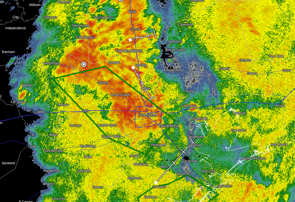
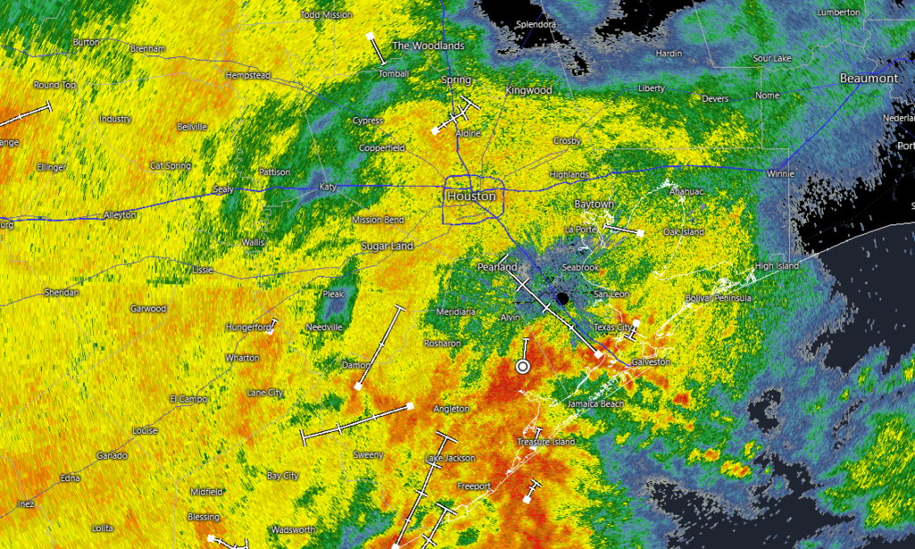
Hi everyone, just a quick update to note that the “afternoon” round of storms we advertised in this morning’s post is now moving through central Houston. This band of showers and thunderstorms is producing heavy rainfall, and we’re seeing some flash flooding consistent with the Stage 2 alert we have put into place for this weekend.
Houston radar snapshot at 4:32 pm CT on Saturday. (RadarScope)
The good news is that these storms are progressing fairly well to the east-northeast, and should gradually clear the entire metro area by around sunset if not before. Accordingly if you have dinner reservations or other plans later this evening you should feel free to go out. Once these storms end we anticipate a quiet evening and overnight period.
As for Sunday, we expect scattered showers and thunderstorms (probably better chances closer to the coast) but nothing as organized as what we experienced today. Memorial Day probably will have less coverage still, with more sunshine. We will break this all down for you in an update on Sunday morning.
In brief: Storms are rumbling through Houston during the pre-dawn hours on Saturday, and this is the first of a handful of disturbances we can expect this weekend. Rain chances are a bit lower on Sunday, and we are hopeful that by Memorial Day we’ll see a fair bit of sunshine.
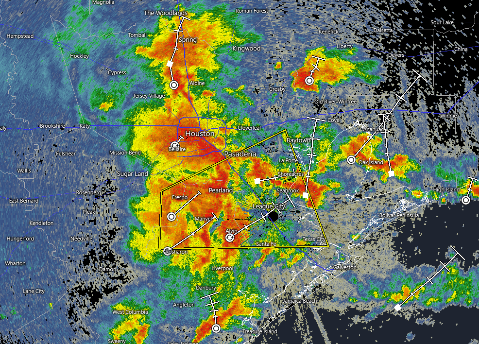
Good morning. Like some of you, I imagine, I was awoken before 5 am by storms rumbling into the Houston area from the west. This pre-sunrise activity is the first of a series of disturbances expected to propagate across the region over the next 24 to 36 hours. We still have some uncertainty about the timing for heaviest rainfall, but I am increasingly hopeful that we will see improving conditions by Memorial Day. Thus, if you were hoping to have a pool day, or a beach day, or otherwise celebrate the holiday outdoors in hopes of a little sunshine, all is not lost.
Houston radar image at 5:54 am CT on Saturday. (RadarScope)
But first, we have some storms to deal with.
The current area of showers and thunderstorms is producing fairly heavy rainfall, and there is also the threat of some severe weather, including small hail and damaging wind gusts. The period between now (5:45 am) and around 9 or 10 am this morning should be treated with caution due to the potential for severe weather as well as pockets of heavy rainfall (we’ve seen rainfall rates of 2 to 3 inches).
So what happens after this round of storms? I think we’ll see a break in activity from the mid-morning to the early afternoon hours. But then, as the atmosphere has time to recharge and we experience daytime heating, another disturbance will approach from the southwest. This will likely spread into Houston during the afternoon or evening hours. Whether it is intense as the storms this morning is not entirely clear—the atmosphere may still be a bit worked over. Some of our high resolution modeling indicates these storms will be strongest along and south of Interstate 10.
We are likely to see more disturbances on Sunday, although timing them is difficult, and it’s not clear how strong they will be. Anyway, expect a healthy rain chance in the vicinity of 60 or 70 percent. By later on Sunday we may be able to lift our Stage 2 flood alert, which is indicative of the waning potential for street flooding and flash flooding.
In contrast to the first part of the holiday weekend, we now think there’s a decent chance of partly sunny (maybe mostly sunny) skies on Memorial Day, with rain chances at or below 50 percent. In other words, most of the day should be fine to celebrate outdoors. Highs will likely be in the vicinity of the mid-80s on Monday, so fairly warm but not in any meaningful way will it be hot.
If the storms this evening look to become fairly strong, we’ll be back with a short update this afternoon. If not, we’ll see you on Sunday morning.
In brief: A round of storms moving into the region today should impact areas south of Houston, including southern Brazoria County which has already been hard-hit by rainfall. Storms should be more scattered in nature on Friday before the likelihood of widespread heavy rainfall ramps up over Memorial Day Weekend.
Rains recap
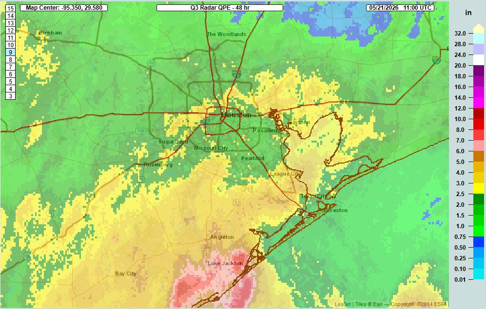
Since the beginning of these late May storms on Tuesday, most of the Houston area has picked up 1 to 3 inches of rainfall, which has been manageable. However areas south of Houston, particularly in southern Brazoria County near Angleton and Lake Jackson, have had a far wetter time of it. Some of these locations have already received 6 to 8 inches of rainfall. Unfortunately for these locations, it appears that rainfall on Thursday will be mostly concentrated over areas south of Interstate 10.
Rain accumulation map for Tuesday and Wednesday. Note the high totals around Lake Jackson. (NOAA)
Thursday
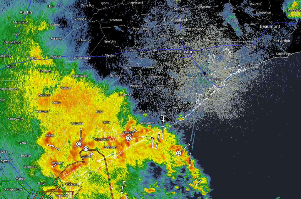
A check of the radar this morning shows a large mass of showers off to the southwest of Houston near Victoria Port Lavaca. These showers and thunderstorms should slowly move to the northeast, toward the metro area this morning. Our latest high-resolution guidance suggests these storms will largely remain confined to areas south of Interstate 10 as they move through during the morning hours, and likely exit to the east by early afternoon. Rain accumulations of 1 to 3 inches will be possible for coastal areas, but I’m hopeful that much of the heavier rain will fall just offshore.
Radar snapshot at 6:35 am CT on Thursday. (RadarScope)
For the rest of the Houston area rain showers and thunderstorms should be more scattered later this afternoon. Skies will be mostly cloudy with high temperatures in the upper 70s to lower 80s. (I have to say that afternoon temperatures on Wednesday afternoon were very comfortable for late May in Houston). Rain chances should be low overnight, with lows around 70 degrees.
Friday
This is looking like a day during which showers and thunderstorms are more scattered in nature rather than organized into a broader system; which is to say rain chances will be a bit lower than the weekend at about 50 percent. With mostly cloudy skies we can probably expect highs in the vicinity of 80 degrees.
Memorial Day Weekend
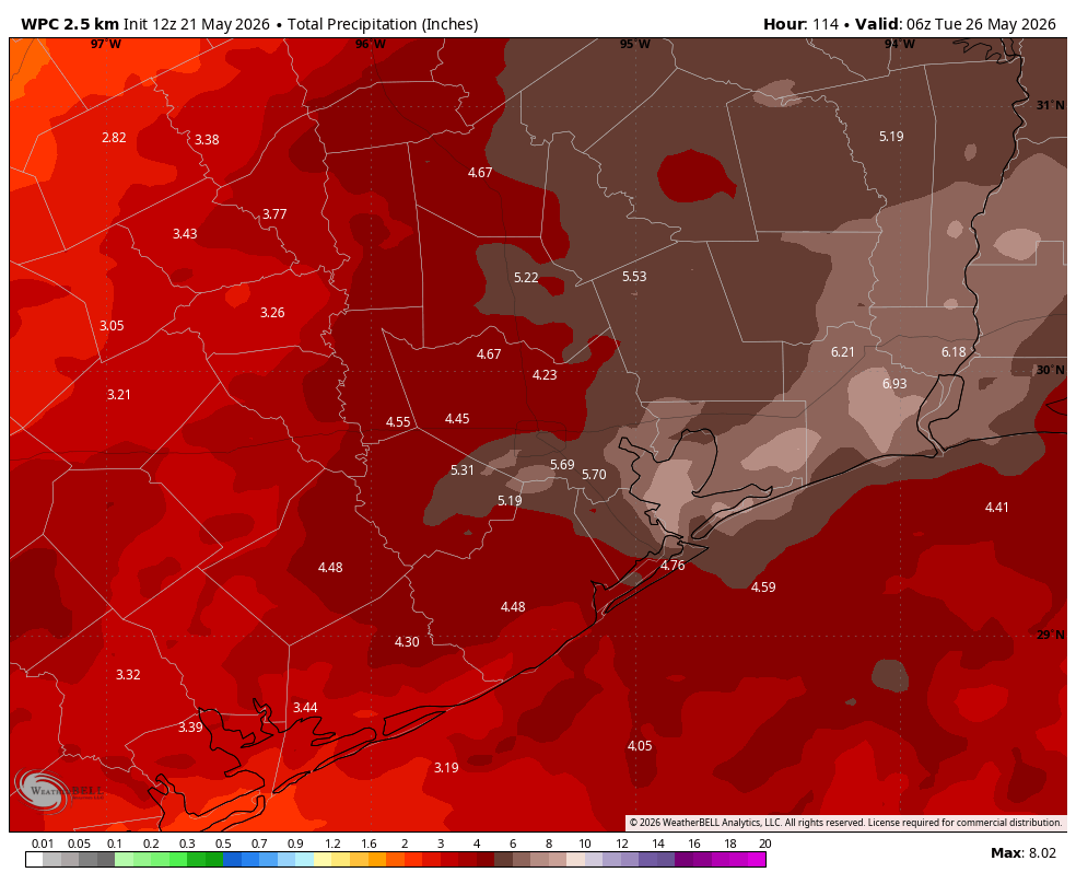
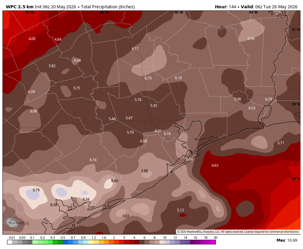
The upper-air pattern will become more amenable to supporting widespread showers and heavy rainfall this weekend as a low pressure system allows the passage of multiple disturbances over the region. Rain chances will be near 100 percent on Saturday and Sunday, and perhaps only a little bit lower on Monday. Most of the area is likely to pick up an additional 3 to 6 inches of rain this weekend, with higher isolated totals leading to at least street flooding, and possibly some flash flooding. For this reason we are maintaining our Stage 2 flood alert through the holiday weekend.
NOAA accumulation forecast for now through Memorial Day. (Weather Bell)
It’s still a little too early to have precise details about timing, but basically you should be prepared for some disruptions at any point this weekend. Certainly roads should be passable most of the time, but these are the conditions that support some impacts to mobility where rainfall is heaviest and/or prolonged. Basically we want you to be alert to the possibility of flooding, but not fear widespread mayhem.
High temperatures should remain in the low- to mid-80s this weekend with plenty of humidity, and nights not cooling down much. Saturday looks to be mostly cloudy, but we could see some breaks in the sky on Sunday and Monday when it’s not raining.
Next week
I don’t have great confidence in the forecast for next week. Daily rain chances continue to look healthy, perhaps in the vicinity of 50 percent or so, but at this point I think (and hope) amounts will be trending downward after Monday. Highs remain in the 80s, probably.
In brief: Tuesday night’s rains were mostly manageable, but they are just the first round of storms that our region will experience over the next week. We now believe the heaviest rain is likely to come this weekend, when flooding concerns will be greatest.
This is just the beginning, not the end
In recent years Houston has often experienced a pattern in which we will see one or two days of rain before a front moves through, or high pressure sets in, or something else happens to turn off the spigot. Then we’ll have a few weeks of sunny skies and no rain. Only rarely have we seen periods of several days of moderate to heavy rainfall as we are now experiencing.
The rain showers across Houston (radar snapshot at 6:35 am) this morning should wane before noon. (Radar Scope)
The ongoing rounds of storms that will rotate into Houston through Memorial Day weekend, and possibly beyond, is probably due to the early phases of an El Niño that appears to be developing in the equatorial Pacific Ocean. This generally promotes a wetter pattern across Texas. This El Niño is likely to peak later this fall or over the winter months, and based on recent model forecasts it could be a rather strong El Niño. So maybe we will see more prolonged periods of rain, and fewer prolonged periods of dry weather.
In any case, the rounds of showers and thunderstorms that passed through the Houston region overnight are likely to continue into early next week. It won’t rain all the time, but for most locations it probably will rain at some point each day. Saturday and Sunday look to have the best chance of precipitation, which will probably spoil a lot of Memorial Day weekend plans. So it goes here at Space City Weather where we don’t control the weather, we just get blamed for it. We’ll be here all weekend, alongside you.
Wednesday
The storms that rolled through over night brought between 0.5 and 3 inches of rain to most locations. As expected, all streams, creeks, and bayous are well within their banks this morning. Flooding will become more likely this weekend, as rain accumulations stack up, and for this reason we issued a Stage 2 flood alert on Tuesday, and plan to hold it in place through the holiday weekend.
Light to moderate rains are ongoing this morning, and the overall trend is one toward weakening rather than strengthening storms. Activity will shift southward over the next couple of hours, and I expect the rains to end entirely across the Houston metro area by or before noon. This afternoon we may briefly see some partly sunny skies, with high temperatures pushing into the mid-80s or so. Lows tonight will fall into the mid-70s. As for rains, I expect low-end chances through the evening hours, so if you have outdoor plans for later today I would be cautiously optimistic.
NOAA rain accumulation forecast for now through Monday. (Weather Bell)
Thursday and Friday
By early Thursday, with our atmosphere recharged, we are likely to see another rain-making disturbance moving into the region from the west. I don’t know whether these storms will be as widespread or active as what we experienced Tuesday night, but they definitely will have the potential to produce another 1 to 3 inches of rainfall. Another, similar, round of storms will be possible at some point on Friday. Highs on both days will be in the low- to mid-80s, with partly to mostly cloudy skies. Again, there are likely to be extended periods when it is not raining, so there will be some time to get outside and enjoy the moderate temperatures (for May).
Memorial Day Weekend
This weekend often kicks off summer in Houston, with sunny skies and our first temperatures in the low- to mid-90s. Well, not this year. A surge of moisture should lead to widespread showers and thunderstorms on both days, with some of these showers producing very heavy rainfall.
By this point we may see rain accumulations from storms this week pushing up to 4 to 8 inches for some locations, so we’ll be tracking creeks and bayous closely. Harris County has an excellent tool for you do to this for locations near you. The National Weather Service also has a good resource for tracking river flooding in our region. Rain chances by Monday may drop to 70 percent.
Highs will be in the low 80s, probably, and if we continue to get morning storms there may be some breaks in the clouds during the afternoon hours. Basically, you’ll need to continue to remain weather aware.
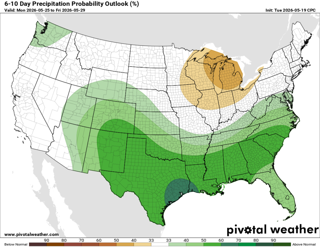
A wet pattern remains likely for next week. (Pivotal Weather)
Next week
After Memorial Day rain chances will probably fall back some next week, but we probably are still looking at something like at least 50 percent daily. This, as well as ongoing partly cloudy skies, should help keep temperatures in check for the remainder of the month—which is to say we might not see 90 degrees again until at least early June.