We’re not there yet, but we’re close. Houston faces four more days of summer-like weather before a strong cold front arrives. And then we should reach the time of the year when fronts arrive with some regularity. There will still be warm days, of course, and periods of humid nights. But 90 degree days? I think after Friday we’re done with those for 2021. There are no guarantees in weather, of course, but if you’re ready for the time of year when most days are in the 70s or low 80s, we’re almost there. It’s not summer. It’s not winter. It’s the in-between time in Houston, and it’s pretty darn glorious.
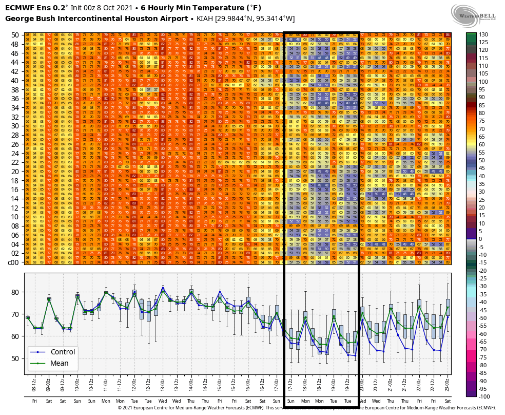
This European ensemble forecast for low temperatures for the next two weeks shows why our pattern is about to change after Friday. (Weather Bell)
Tuesday
Most of the region is seeing a sticky morning, and with a mix of sunshine and clouds later today highs should warm to near 90 degrees. The atmosphere will be just disturbed enough to allow for the development of isolated to scattered showers this afternoon, which would be short lived. Winds will be out of the south at about 10 mph. Tuesday night will be mostly cloudy, with lows in mid-70s.
In Chicago, weather for today’s make-up of Game 4 between the Astros and White Sox looks good, with partly sunny skies and a high of around 70 degrees. Time to close out the series!
Wednesday
A hot day, with mostly sunny skies and highs near 90 degrees. Winds will be out of the south, to go along with rain chances of around 10 percent or less.
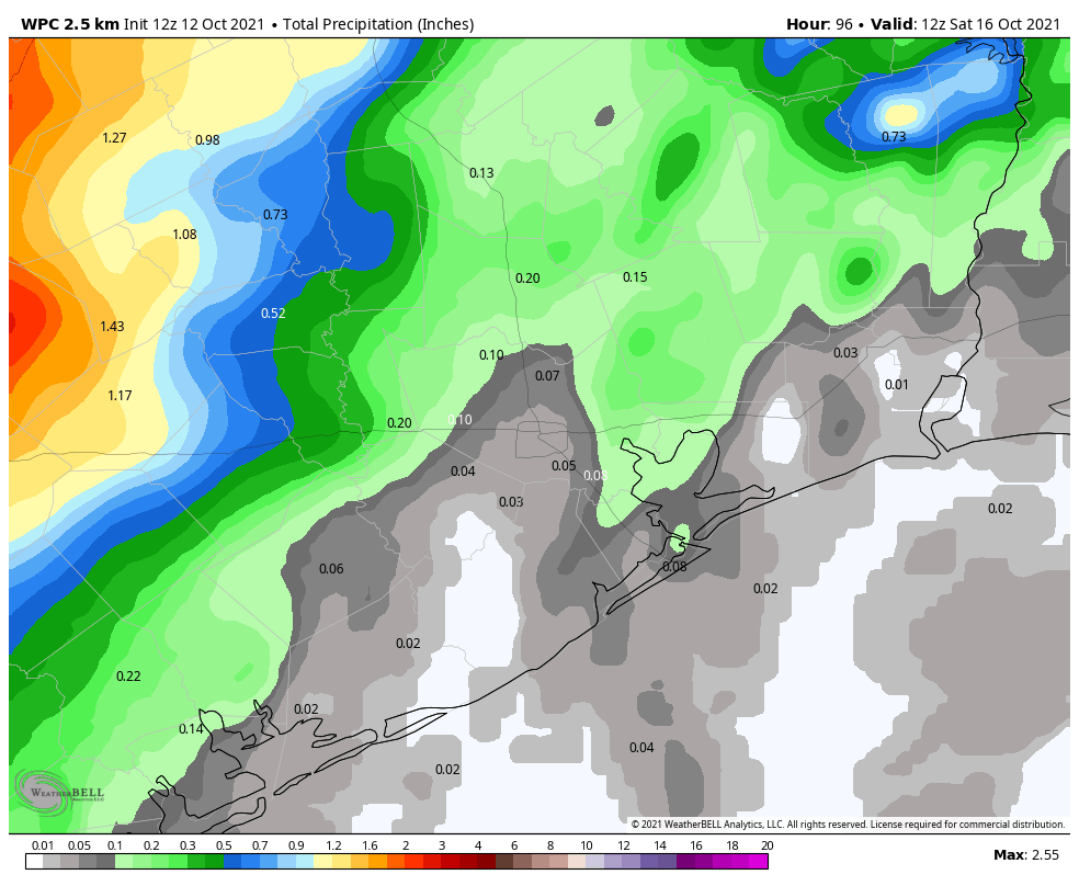
NOAA rain accumulation forecast for now through Friday. (Weather Bell)
Thursday and Friday
These will be muggy, warm days with highs of around 90 degrees. Skies will be partly to mostly sunny, with perhaps a 30 percent chance of rain each day. The aforementioned cold front is due to arrive on Friday evening-ish, likely pushing well off the coast by midnight, or early Saturday morning. At this point I do not expect an organized line of storms with the front.
Saturday, Sunday, and beyond
The weekend looks fabulous, with days in the 70s, nights in the 50s, and partly to mostly sunny skies. A slow warm-up trend begins by around next Tuesday or Wednesday, but we’re likely going back to the low 80s for highs, with lows in the 60s. After Friday, rain chances appear to be low to non-existent for awhile.
Good morning Houston. The storms that rumbled through this morning before sunrise heralded the arrival of a weak front that, unfortunately, won’t provide too much of a lasting impact on our heat and humidity. However, our confidence is high that another, more significant front will arrive on Friday to usher in fall-like weather. Next weekend looks superb.
Monday
In the wake of the weak front, inland areas should see clearing skies and somewhat drier air this afternoon and evening, with high temperatures reaching the mid- to upper-80s. Closer to the coast, clouds will linger as the front essentially passes through and expires. Winds, for the most part, will be out of the northwest today at 5 to 10 mph. Low temperatures tonight, except for far inland areas, will be in the 70s.
Astros weather, Game 4
The Astros face the White Sox in game four of the American League Division Series today. Game time is set for 2:37 pm CT, and the forecast is iffy. The Windy City will live up to its name today as a front passes through the region. Wind gusts will reach about 30 mph, and showers and thunderstorms are very possible from about 3 pm to 9 pm today. Play ball? Hopefully.
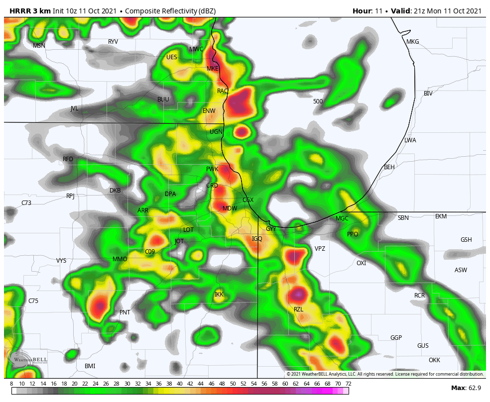
One model’s forecast for storms in the Chicago region at 4 pm CT on Monday. (Weather Bell)
Tuesday, Wednesday, and Thursday
Back in Houston, the region will see warm and muggy weather through the middle of the week. These days will see partly sunny skies, highs in the upper 80s to 90 degrees, to go along with low rain chances of about 20 to 30 percent daily. Overnight lows will be sticky, in the mid-70s.
Friday
Tropical Storm Pamela has now formed in the Pacific Ocean, off the coast of Mexico, and the system will affect our weather toward the end of this week as it curves back into Mexico and its remnants approach Texas. The tropical system may increase rain chances in Houston later on Thursday and Friday, and should also help drag a stronger front through the state and off the coast. As a result I think we’ll see some decent rain chances on Friday and Friday night as the front pushes through. Daytime highs will likely be in the upper 80s, with overnight lows falling to around 60 degrees.
Tropical Storm Pamela should influence Houston’s weather late this week. (NOAA)
Saturday and Sunday
In the wake fo the front, the weekend looks splendid. Look for highs in the 70s, with lots of sunshine, and lows in the 50s on Sunday and Monday mornings.
I hope everyone is enjoying our mostly sunny weekend. We should continue to see partly to mostly sunny skies today, with highs of about 90 degrees. There will be one noticeable difference, however—winds will pick up out of the south and become a little gusty this afternoon. This is a harbinger of atmospheric moisture levels rising across the area. Still, aside from the potential for a very few, very scattered showers, it should be a quiet day.
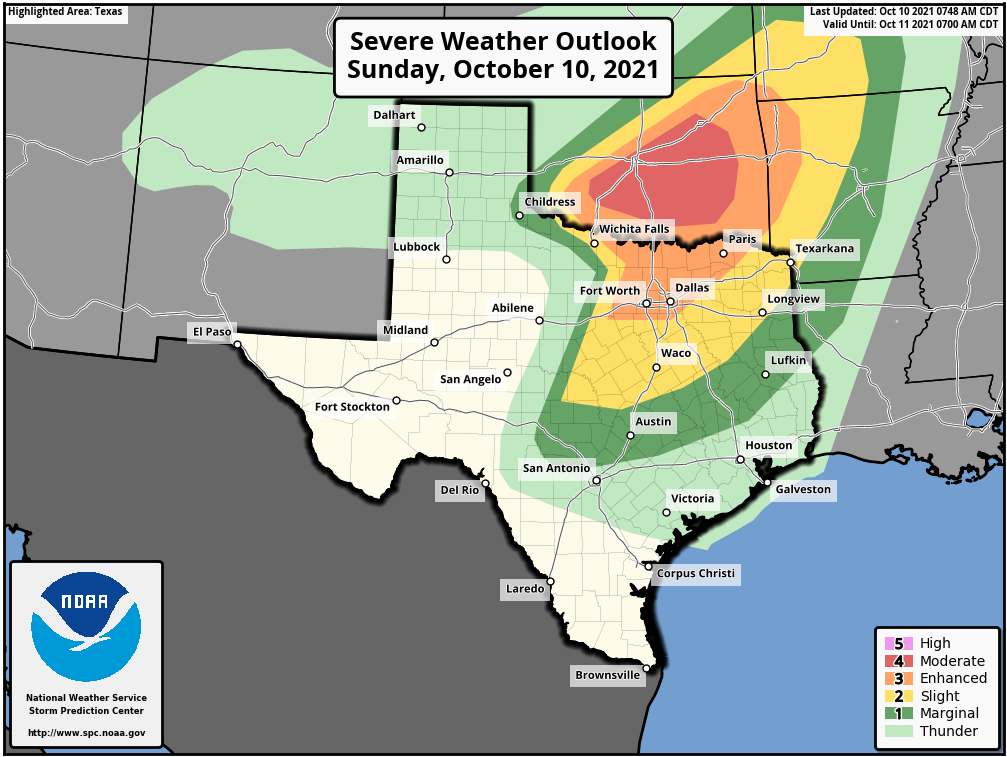
Conditions may change tonight as a line of storms associated with a cold front moves southeastward across the state of Texas. These storms could be especially severe in the Dallas-Fort Worth metro area on Sunday evening, likely from around 7 to 10 pm. This is something to consider if you’re traveling back to Houston from North Texas tonight.
Severe weather outlook for Sunday and Sunday night. (NOAA)
This line of storms will weaken some as it moves closer to the Houston metro area, pushing through College Station after midnight, and likely reaching the central Houston region by around sunrise or before. The main threat from these storms will be damaging winds and hail. My sense is that the storms will weaken enough to not provide too much disruption to Monday morning’s commute, but please do be aware of the possibility of showers and thunderstorms early on Monday. Things should clear out quickly, regardless.
The other question concerns whether this front pushes all the way through Houston and to the coast. Some modeling now suggests it briefly will move to the coast, giving the region a dash of notably drier air on Monday and Monday night, but it’s going to be close. We’ll know for sure by tomorrow morning’s post.
It’s tough to argue with the stretch of weather we’ve had this week. It’s been warm, certainly, but with pleasant mornings and evenings and generally low humidity, it’s been pretty outstanding. We will have changes beginning this weekend, and those will set the stage for our weather next week.
Today & Saturday
Both days should be sunny and warm. Look for highs near 90° today with generally low humidity. A similar story unfolds tomorrow with perhaps just a few more fair-weather clouds dotting the sky. Morning lows will be in the 60s or low 70s again. The dewpoint, or how much moisture is in the air will be a couple ticks higher tomorrow, so you may notice it feels a bit more humid, especially in the morning. Patchy fog is also possible in the morning.
Two other quick notes: Air quality has been atrocious this week. The combination is two-fold: An inversion (temperatures warming as you go up in the atmosphere) has trapped pollution and smog near the surface in the morning hours leading to an ugly haze. That should continue today and perhaps tomorrow. Secondly: The full sunshine has led to high levels of ozone each day in the area. This isn’t as visible to the eye, but it can trigger some respiratory ailments in people. On top of all this, if you’re a seasonal allergy sufferer (raises hand), you’ve felt it this week. Ragweed is a big problem, as are mold spores. But, I mean, aside from that, it’s been great!
Sunday
Our transition begins in earnest on Sunday. You’ll notice it a couple ways. First, expect sun and a few more clouds. Second, there could be a few light showers around, especially in the morning hours and especially southwest of Houston. The humidity will also be noticeably higher. In addition to all this, you’ll also notice the wind pick up Sunday. We’ve had a pretty lengthy stretch of light or calm winds this week, but onshore flow builds on Sunday with some 20 to 25 mph gusts possible, particularly near the coast. I don’t think this will be so much wind that it will impact Wings over Houston, but it’ll be a noticeable change.
While not particularly troublesome, wind gusts of 20 mph or so will be possible by Sunday afternoon, which is more wind than we’ve had all week. (Weather Bell)
Look for high temperatures on Sunday in the mid to upper-80s after morning lows in the 70s.
Monday
A cold front will take a swipe at the area on Monday, but it will likely come up short, fizzle, and/or quickly retreat back to the north. It will come close enough however to set off a few showers or storms Monday. We aren’t expecting anything too widespread, but some areas may see their first measurable rain in a good while. Look for warm and humid conditions with a continued onshore breeze. Expect mid to upper-80s after morning lows in the 70s.
Midweek
Tuesday through Thursday get a little more murky. The general expectation should be for warm, humid weather to continue. We’d likely see highs in the 80s and lows in the 70s. We would have at least a few showers in the area each day, but I am guessing the atmosphere will be fairly “capped” next week, meaning thunderstorm development would be tough to come by. That’s a typical Houston-area setup in autumn. Clouds and sun would take turns each day, aside from the isolated showers.
Late week
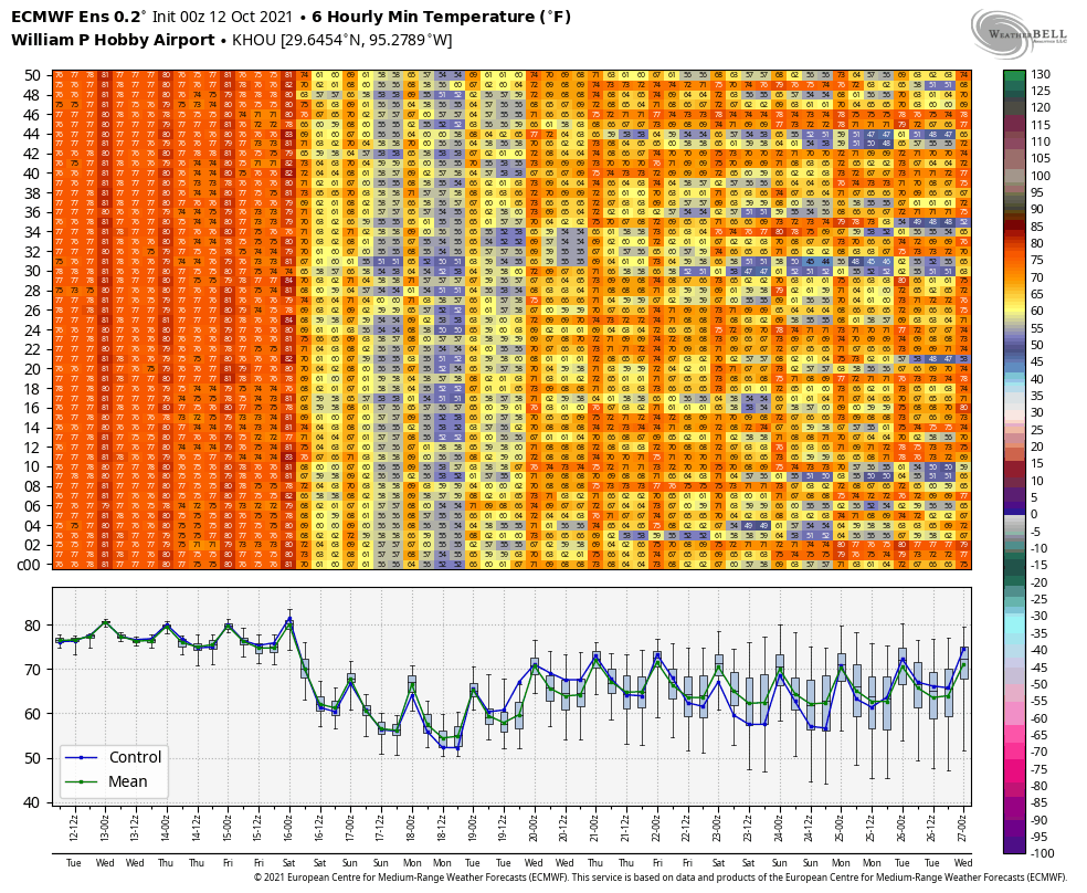
Here’s where the fun begins. When I wrote my post last Friday, I noted that there was no sign of a meaningful cold front for the foreseeable future. I cannot say that this week, however. Model support and evidence is building that a cold front, possibly a strong one, will push through the region sometime late next week or weekend. Over 90 percent of the Euro ensemble members (shown here) and over 50 percent of GFS ensemble members (not shown) have some sort of front pushing through next Saturday-ish.
Model support for a legitimate cold front is increasing for next weekend with lows in the 50s possible once again. (Weather Bell)
Of those Euro ensemble members, about 65% have lows in the mid-50s or cooler possible next Sunday or Monday the 18th. We will see if that can get us into our rhythm for the cool season here, which typically sees a front at least every week or so. Obviously, folks will be watching cold fronts with a little more urgency this year after February’s disaster. It’s still quite early, but we’ll be watching closely through the winter too.