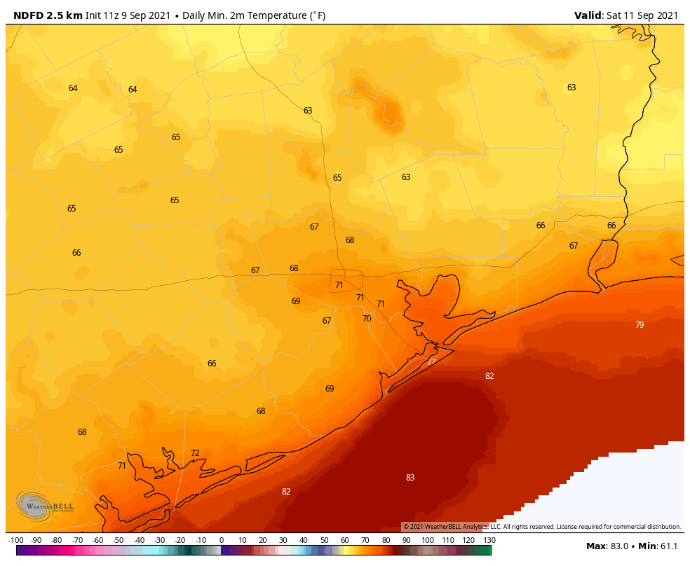
For some folks, today is the coolest morning in months! Crockett, for instance, is down into the 50s. IAH, at least as of 6 A.M. has not gotten under 70 just yet.
We will see if we can match our cool day of the week (69° on Wednesday) or even sneak just below it before the sun gets up. Either way, it’s comfortable out there today, and we’ll be closing the week on a very high note. Enjoy it, because things will begin to change in earnest later this weekend. We detail the situation below. Look for a post later today that will set our initial Flood Scale expectations for next week.
Today
No issues whatsoever. It’s beautiful. Enjoy it if you can. We will see highs peak in the 90s with abundant sunshine and rather comfortable humidity.
Saturday
While Saturday morning won’t start off quite as cool as we are this morning, it should still be a pleasant start to the day, with morning lows ranging from the 60s inland to 70s near the coast. There is even a chance that Galveston checks in cooler tomorrow than it did today. Look for more sunshine, highs in the 90s, and perhaps just a tinge higher humidity.
Sunday
The end of the weekend will bring the beginning of our transition into the wet period we’re expecting. I would expect at least a chance of thunderstorms in Houston and south of I-10 with increasing clouds elsewhere. Morning lows in the 70s will warm into the upper-80s or low-90s depending on how much sun you see. No serious problems are currently anticipated Sunday, but if you have outdoor plans, keep the rain chances in mind.
Next week
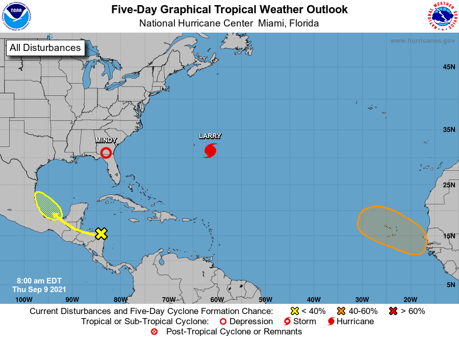
So let’s talk about next week. There are a number of factors that will go into exactly how next week plays out, some of which are rather low confidence still today. But in general, expect increasing rain chances Sunday through Wednesday, with locally heavy rainfall and potential for at least some flash flooding concerns, especially south and east of Houston and along the coast. Let’s walk through some of the players and how they will influence what happens next week.
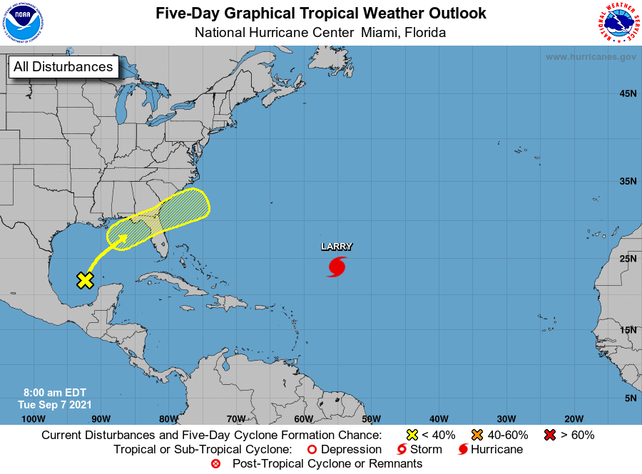
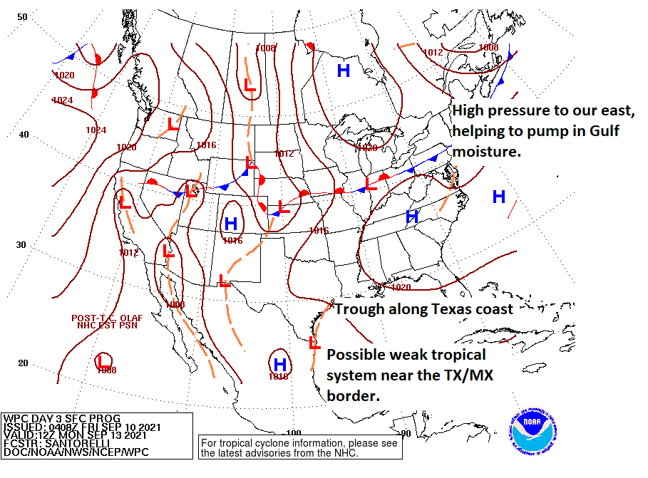
First, the primary reason next week looks wet: High pressure over us today will leave us to the east over the weekend, steering Gulf moisture back into the area. The remains of our cold front offshore transition to what we call a surface trough. And then you may add a tropical system to the mix in northern Mexico or far south Texas. You can see this all reflected on a forecast surface map below.
Confidence is relatively high that the high pressure area will move to our east and open the door to Gulf moisture. So that much we know. Where confidence drops is in relation to possible tropical development off the Mexico or Texas coast.
Odds have been increasing that whatever moves into the Bay of Campeche this weekend will develop into a tropical depression or weak tropical storm. That’s one thing we have moderate to high confidence in: That this system has a rather low ceiling in terms of intensity. It should track along the coast and north, probably making landfall in northern Mexico or far south Texas on Monday sometime.
This will matter some, however because the exact location of the track and how well organized this disturbance is will help dictate where the highest rain chances are located and how high the totals will be. These situations are not straightforward. Sometimes you’ll see the heaviest rain hug the coast or just inland and cause flash flooding problems. Other times the heaviest rain will fall offshore and end up mostly harmless for coastal communities. We just don’t know at this point exactly what it will look like.
Here’s what I think we can say right now, with some level of confidence:
- We will have periods of thunderstorms beginning later Sunday and continuing into Tuesday or Wednesday of next week.
- It won’t rain the entire time, and there may be some substantial breaks in the rain, especially north of I-10.
- Rain will likely be heavy at times however, especially along the coast and possibly south or east of Houston.
- Localized street or flash flooding is possible, especially south and east of Houston, but it is too soon to tell you exactly where and when that may occur.
- Rain totals of 2 to 6 inches on average for most of the area between Sunday and Wednesday, with the highest totals in smaller pockets south and east of Houston, perhaps up to 8 to 10 inches or even more.
- While tropical development is becoming increasingly likely, we do not expect this to be a wind or surge issue for us. Some rough seas, rip currents, and elevated tides will be possible, but development should remain weak enough and far enough to our south to avoid the wind & surge problem. This will be almost exclusively a heavy rain situation for us.
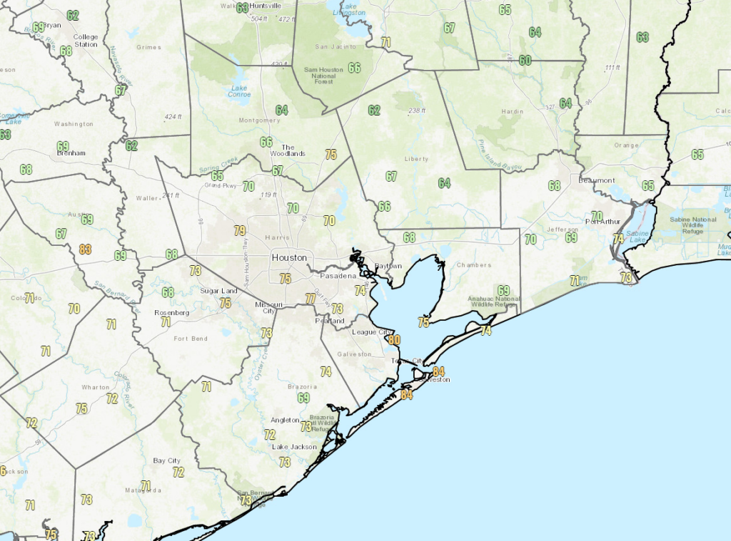
Here is the current NWS rainfall outlook into next week.
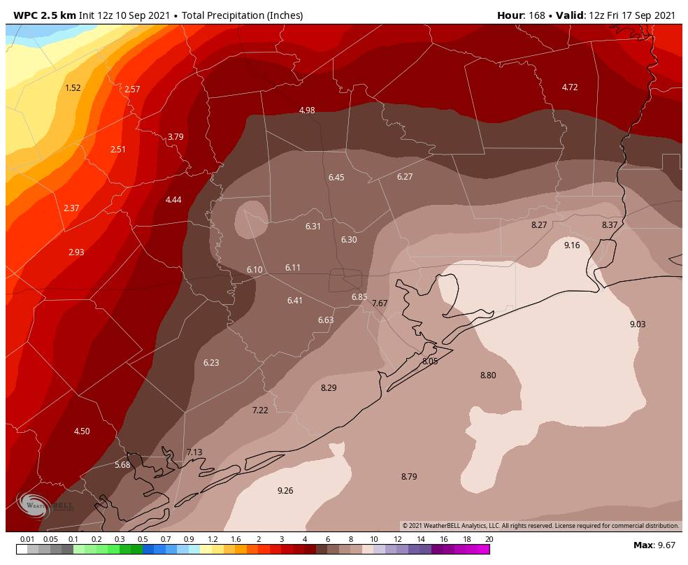
While some areas will probably see less rain than forecast above, their placement of the bullseye totals south and east of Houston is logical right now, and higher amounts are possible in those areas.
Drier air and lower rain chances should begin to build in after Wednesday.
After we digest the morning weather model data, look for a post from Eric later this afternoon that will initiate our Flood Scale outlook for this event. And we’ll keep you posted over the weekend.