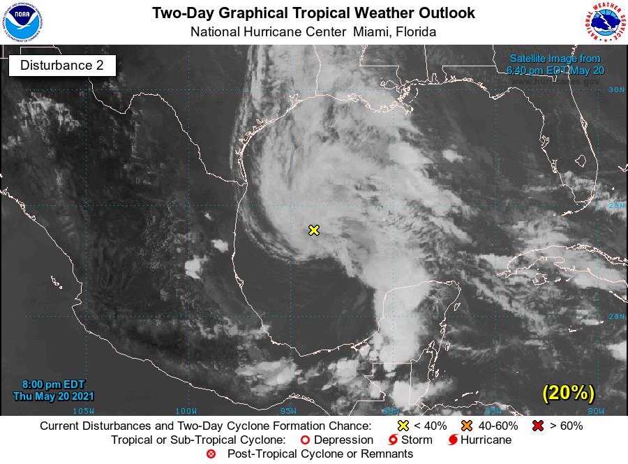
Throughout today the European forecast model has been advertising the potential for a tropical disturbance to develop in the Gulf of Mexico, and then move toward the Texas coast this weekend. This evening, in its 7pm CT update, the National Hurricane Center gave this system a 20 percent chance of developing into a tropical depression over the next two days.
(National Hurricane Center)
Here’s what we can tell you: this system very likely will not have much impact on our region’s weather. We have already forecast a healthy chance of rainfall on Friday and Saturday along the upper Texas coast, and that will not change. Our expectation is that most of the region from Houston to Beaumont will see an additional 1 to 2 inches of rain through Saturday night, with higher isolated totals. All of this should be manageable despite our recent rainfall.
This Gulf low pressure system, which remains poorly organized this evening, is forecast to track north, and then northwest, likely approaching the Texas coast late on Friday night or Saturday. Although there is the possibility it may organize somewhat, it will also be drawing in somewhat drier air that will limit this.
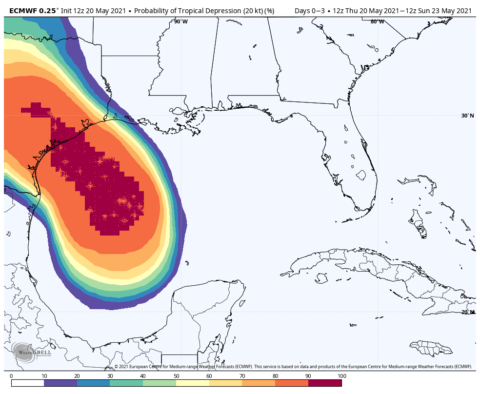
European model prediction for where a Tropical Depression may form. (Weather Bell)
The bottom line is that yes, we realize no one wants to see a tropical blob in the Gulf of Mexico. However, this one likely carries a minimal threat, and we expect the region to really begin to dry out on Sunday. We’ll have more in the morning.
Good morning. The Houston region should see a quiet day today, with scattered showers, before more widespread rain chances return on Friday and Saturday. Overall accumulations, however, should generally remain in the 1 to 4 inch total through Saturday. We therefore are dropping the use of our flood scale as the overall threat diminishes further. It is worth noting that a bit to our east, particularly the Beaumont and Port Arthur areas, could see a bit heavier rainfall this weekend. They were hit much harder earlier this week.
I also want to call attention to a special discussion this afternoon at 3 pm CT, which you can register for here. As part of an event produced by the South Main Alliance, Leroy “Shafe” Shafer, the longtime chief operating officer of the Houston Livestock Show and Rodeo, will interview me. We’ll talk about the origins of Space City Weather, the upcoming hurricane season, and the writing of my book on the early years of SpaceX, Liftoff. The event is free!
Thursday
Our radar is blessedly clear this morning, and we expect only isolated to scattered showers later today. It is possible that the sunshine may peek through for a bit this afternoon or early evening, but skies should remain mostly cloudy. Highs will climb into the low 80s this afternoon, with overnight lows in the low 70s.
Friday
Rainfall should become more widespread beginning early Friday morning, and we’ll see fairly high chances all day. However, these storms should be fairly fast moving, and most areas will likely see less than 1 inch of rain. Highs will be around 80 degrees with mostly cloudy skies. Rain chances will slacken a bit overnight.
Saturday
One final burst of moisture arrives on Saturday, and in the upcoming period this should be the day when our region has its best rain chances. Much of Houston could see around 0.5 to 1.5 inches of rain on Saturday, give or take, with mostly cloudy skies and highs around 80 degrees. This won’t be great for outdoor activities, but at least we do not anticipate any significant flooding from these rains.
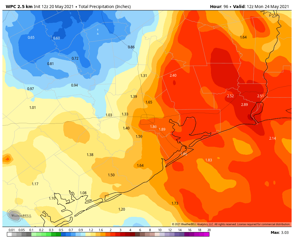
NOAA rain accumulation forecast for now through Sunday. (Weather Bell)
Sunday
Rain chances aren’t going to entirely go away on Sunday, but they should drop back quite a bit. We also expect to see at least a modest amount of sunshine during the afternoon hours, although I’m not sure it’s going to get full blown sunny on us. Highs will probably reach the low 80s.
Next week
Skies will turn partly, and then probably mostly sunny next week. This will allow high temperatures to climb into the mid-, or possibly upper-80s by the end of the week. Some slight rain chances will remain each day, but any showers that develop look to be fairly scattered in nature. It’s late May, so you should know better than to inquire about future cold fronts.
Good afternoon. The atmosphere has behaved itself so far today, with most of the area seeing one-half inch of rainfall, or less, since sunrise. We expect this trend to continue today and tonight. Yes, rain will be possible. No, it should not be extreme.
Overall, we think the threat of a big ticket rainfall event—which will lead to significant flooding—is diminishing this week. Therefore we are lowering out Space City Weather Flood Scale alert level to Stage 1. This means we can mostly expect nuisance street flooding over the next couple of days.
That’s not to say the rain is over.
Showers will continue to be possible along the coast this afternoon and tonight. On Thursday, we expect showers to be more scattered in nature, offering a nice reprieve. But beginning Thursday night we could see redevelopment of more widespread activity, and then the potential for moderate or even heavy briefly rainfall on Friday and into Saturday morning. Overall accumulations will likely be in the neighborhood of 1 to 3 inches of rainfall, with higher isolated amounts possible south of Interstate 10, closer to the coast, and east of Houston. Even though the region’s soils are saturated, we just don’t see a huge threat to the metro area. Obviously, we’ll be tracking things closely until the risk is over.
Unless there’s a change in our thinking, we’ll next update on Thursday morning.
I have to admit, I enjoyed Eric’s somewhat euphoric post at midnight. Though as the parent of a toddler and infant that slept — how can I say this? — poorly, for lack of a better word, it was a long night. I’m sure many of you with kids and pets can relate!
But seriously, although it was a wild evening, the city of Houston and most of the metro area are doing fine this morning.
Flood Scale remains Stage 2
That said, I am going to hold our flood alert at Stage 2 out of an abundance of caution. Based on model data, I think most areas north of I-10 are realistically down to Stage 1 concerns going forward, as most rain is projected to fall south of I-10 today. Given some heavier rains already this week south of Houston (and east of Houston), I just think we should hold at Stage 2 and watch the next cluster of storms later this morning and afternoon that may graze those areas, and just make sure tonight looks to avoid anything serious in Houston. Forecasting this has been and remains tricky, and as expected, the evolution of the storms has not gone quite as modeling suggested even 1 to 2 days ago.
The NWS intends to keep Flash Flood Watches going through midday Thursday for the entire area.
Water levels
A look at the Harris County Flood Control map of water levels as of 6 A.M. shows only a handful nearing bankfull or out of their banks.
With the exception of just a few locations, bayous remain in their banks this morning with minimal problems across the area. (Harris County Flood Control)
Expect just some minor lowland flooding in spots.
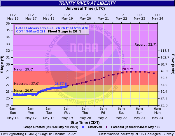
We will need to watch some primary river levels in the coming days, particularly southwest of Houston (though the Brazos looks to remain below flood stage in our area for now), as well as the Trinity River east of the city, which is currently forecast to approach major flood stage at Liberty by the weekend.
The Trinity River at Liberty is expected to approach major flood stage by the weekend. (NOAA)
This would yield significant lowland flooding and some house flooding potentially as well. We’ll keep you posted on this, as there could still be some changes to river forecasts as the future rainfall forecasts are revised.
Today
Rain continues in the Houston area this morning, but it’s falling at the rate of about a quarter-inch or less an hour. That is manageable and should not cause any additional serious trouble.
Our attention will focus to another cluster of storms developing over Mexico this morning. The good news is that this seems to be lined up to stay well south of virtually the entire Houston area. We’ll probably see rain or showers continue through mid-morning, and there will continue to be a chance of showers through the afternoon. But any organized, heavy rainfall likely stays well south of Houston.
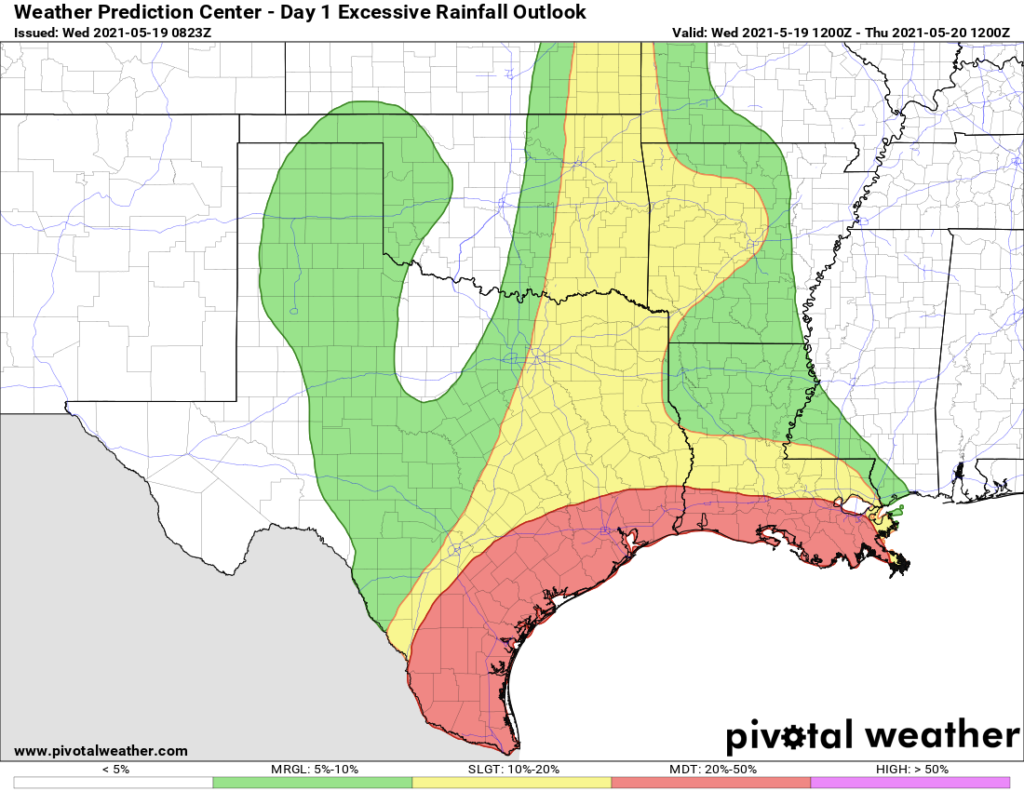
A moderate risk of excessive rainfall is noted today from I-10 south to the coast, but the highest risk of problematic rains appears to be from about Matagorda County southward. (Pivotal Weather)
The Weather Prediction Center arm of NOAA continues a moderate risk of excessive rainfall, essentially from I-10 south to the coast. And this may even be skewed a bit far north given trends on models this morning. The biggest problems will most likely be from Matagorda County south past Corpus Christi. But if current trends hold, even Matagorda County may not be too bad. But they have seen 3 to 4 inches of rain since midnight south of Bay City.
Tonight and Thursday
The good news is that it appears that models have tapped the brakes a bit on significant, widespread heavy rainfall in this timeframe. That doesn’t mean it won’t rain. It also doesn’t mean we’re entirely out of the woods with respect to flooding risk. But at this point, there seems to be a lack of model data arguing for serious rainfall tonight or tomorrow.
So, let’s call it a chance of showers and thunderstorms at virtually any time tonight or tomorrow. If a storm does develop it will be capable of producing heavy rainfall. But at this point we don’t expect significant, widespread rainfall. We’ll continue to monitor for any changes.
Friday
There are some indications on models that the atmosphere may recharge a good bit by Friday, with more available atmospheric moisture. This could lead to another round of heavy rain and storms, but details are fuzzy. This might be a period to keep an eye on though. Improving conditions will arrive this weekend.