Good morning. Houston’s summertime pattern will continue for the rest of this week, with hot days and a decent chance of afternoon showers and thunderstorms. These storms will be hit or miss—a few locations in the Houston region saw one-half inch of rain on Tuesday afternoon and evening, while most people saw no rain at all.
Wednesday
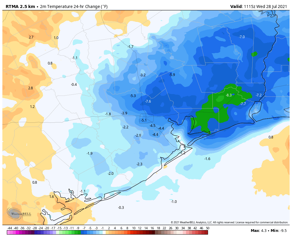
If the air feels a tiny bit drier this morning you can thank some thunderstorms that developed on the east side of Houston on Tuesday evening. These ushered some slightly cooler air into the region. This may slow development of showers today, but we still expect at least scattered activity later this afternoon and evening. Probably about one third of the area will see at least some brief showers, with a few locations seeing downpours. Highs should get into the mid-90s with light easterly winds. Lows tonight may briefly drop below 80 degrees.
Temperatures are slightly cooler this morning due to storms east of Houston overnight. (Weather Bell)
Thursday and Friday
Quite honestly the setup does not change much. Skies will still be partly to mostly sunny, with highs in the mid-90s, and a chance of afternoon and evening showers.
Saturday and Sunday
As high pressure becomes a little bit more dominant this weekend I think rain chances will lower a bit, but not go away entirely. Mostly, we’re going to see sunshine and hot weather, with highs likely in the upper 90s. August begins on Sunday and yeah, it will feel like it.
Temperatures may cool slightly next week due to increased shower activity. (Weather Bell)
Monday and beyond
Monday looks hot and sunny again, but thereafter a dying front approaching Houston from the northeast may act to raise rain chances and slightly lower temperatures. We may be talking highs in the low 90s and rain chances of 50 percent or higher, but at this point it’s difficult to have too much confidence in such a forecast.
The last time we had a tropics post was back on July 13th, and since then zero storms have formed. By July 30, 2020 Isaias had formed. We’re still stuck on Elsa this year, and I hope no one is complaining. It would seem that the next week or two, broadly, will continue on this quiet trajectory. Today, we will look into perhaps why things have been so different this month compared to a year ago.
Tropical outlook in a sentence
While one can never rule out a rogue “homegrown” system this time of year from a disturbance over the Gulf or off the Southeast coast, there is no sign of any organized activity in the Atlantic over at least the next 7 to 10 days.
2021 vs. 2020
So the obvious question here is “what gives?” Why has 2021 behaved so differently from last season? Well, for one 2020 was not “the norm.” At all.
The 2020 Atlantic hurricane season
We had 30 named storms last year. The defeatist in me really did expect this season to also be very busy by now, even if it lagged 2020 by a bit. That has not yet happened thankfully, and ultimately I think it mostly comes down to a law of averages in some sense. Of course, that doesn’t explain things scientifically. Let’s look at a couple things.
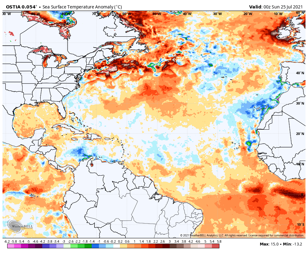
First, sea surface temperature. How warm is the Atlantic Basin right now? Well, if we look at a snapshot of recent water temperature anomalies, you’ll be able to see that we’re still a bit above normal in most of the Atlantic.
Water temperatures in the Atlantic Basin are running a little warmer than normal, especially in the Gulf and at higher latitudes. (Weather Bell)
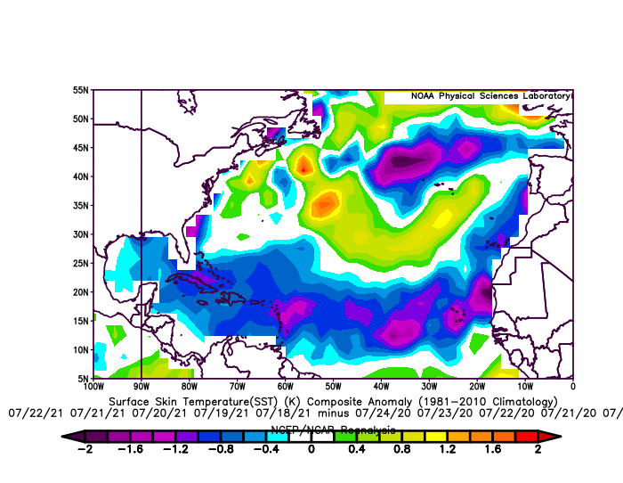
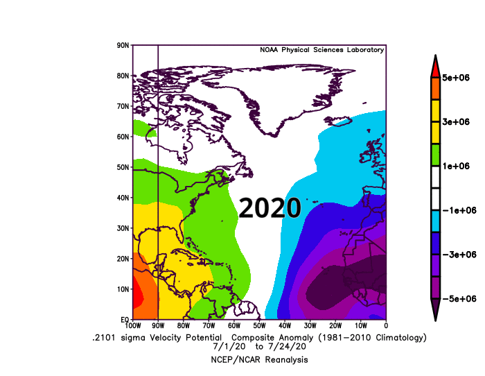
Now, granted, the water temps off the Southeast coast and in the eastern Caribbean and central Atlantic aren’t impressive. And indeed, this is notable, particularly when you look at how late July compares in 2021 versus last year. The map below shows water temperatures for the week of July 18th through July 24, 2021 minus the same week in 2020.
Water temperatures are notably cooler in the tropical latitudes of the entire Atlantic basin in 2021 versus a year ago for the week of July 18-24. They are warmer in the subtropics and at higher latitudes. (NOAA)
In some cases, we’re running 1 to 2 degrees cooler than a year ago, at least for late July. So that may be one reason why this year has lacked some of last year’s firepower to date.
Let’s go into the meteorological weeds a bit. If we look at a metric called “velocity potential,” or “VP,” we can see a very interesting year over year difference in the Atlantic basin. Without getting too deep into things, think of negative velocity potential values as being favorable for tropical development and positive ones as being unfavorable. This is especially true if those values are over the eastern half of the Atlantic basin. Negative VP will promote more rising air & thunderstorm activity in the background, while positive VP will promote more sinking air and fewer robust tropical waves. It’s much more complex than this, but at a very high level, that explains some of the basics.
In July of 2020, a favorable background environment dominated the eastern half of the Atlantic basin, allowing waves to frequently form and track across the basin. In 2021, things have been much less favorable for that to occur. (NOAA)
In a nutshell, the deep purples on the map above indicated a lot of smoke on the water in 2020, which ultimately meant a number of tropical systems. Edouard, Fay, Gonzalo, Hannah, Isaias, and a bonus tropical depression all formed in July of 2020. This July is likely to finish with just one storm, Elsa. Looking at the map labeled 2021 above, you can see the reds and oranges in western two-thirds of the Atlantic basin, Caribbean, and Gulf, along with much less blue and purple over Africa and the eastern basin. Thus, the background state this July has been less favorable than it was a year ago and subsequently, it’s been a fairly quiet month.
The obvious question is whether that will change. In general, based on most modeling I’ve seen, this is expected to change a bit in August to a pattern not as robust as 2020 but at least something more like it perhaps. So in addition to climatology favoring our typical ramp in tropical activity in August and September, we may get a subtle addition from the overall background state too. My gut feeling is that August will start quiet, but as the month wears on, we will have systems to watch closely, as we typically would in any hurricane season. I don’t think it will be quite at the frenetic levels of 2020 or even 2017, but to be sure, it won’t stay this quiet forever. My advice? Enjoy what we have left of the quieter conditions, and make sure you’ve got your plans and kits together for the August and September gauntlet.
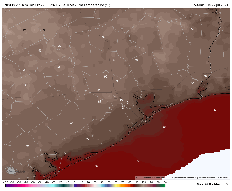
Congratulations, Houston. We’ve made it to the hottest time of year, and Mother Nature has responded right on cue. The high temperature reached 99 degrees at Bush Intercontinental Airport on Monday, tying our hottest day of the year, when the mercury also hit 99 on June 13. We’ll see plenty of more days in the mid- to upper-90s this week. Fortunately, there will also be at least some scattered showers that may break the heat now and then.
Tuesday
For much of the metro area, temperatures have not fallen below 80 degrees this morning. This is due, in part, to mostly cloudy skies and very light winds. Later today we’ll see a mix of sunshine and clouds, with highs likely topping out a couple of degrees cooler than on Monday. Some showers have developed in response to low pressure south of Louisiana, and some rain from this system may eventually work its way into Galveston County later this morning.
The better rain chances—probably about one-in-three for the greater Houston area—will come this afternoon along with daytime heating. This rainfall will probably take the form of a downpour for one area, and nada a mile or two away. The best chances for accumulation are probably inside the Sam Houston Tollway, but rain could really fall anywhere. Storms should continue this evening, before dying off after sunset. Lows tonight may drop into the upper 70s.
Highs Tuesday should be a couple of degrees cooler than on Monday. (Weather Bell)
Wednesday and Thursday
Expect more of the same with partly to mostly sunny days, highs in the mid- to upper-90s, and about a one-in-three chance of rain at your location. These showers, again, will likely fire up during the afternoon hours and die down as the sun sets.
Friday and Saturday
It looks like high pressure may slide a little bit closer to our region by this weekend, and that could reduce rain chances to “isolated” instead of “scattered.” Basically it means the same thing—it probably won’t rain at your house, but it might. And if it does, rains could briefly be heavy. Highs will remain in the mid- to upper-90s with partly to mostly sunny skies.
Sunday
The second half of the weekend may be a little warmer, with sunny skies and low rain chances. Some locations may come close to 100 degrees.
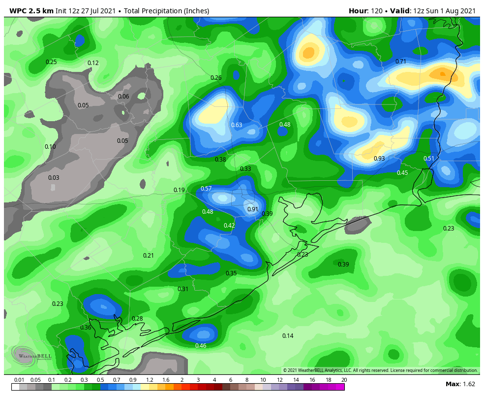
NOAA rainfall accumulation map for now through Saturday. (Weather Bell)
Next week
I don’t have too much confidence in weather next week, the first full week of August. I will say that right now it does not appear as though we’ll be fully in the grasp of high pressure, which means there’s at least a puncher’s chance of rain most days. But with that said, it will be August. And let’s be honest, August is pretty miserable in the 713.
Tropics
Matt will have a full rundown for you later this morning. Things still look pretty good but we’re just now approaching the time when activity starts to kick in, typically.
The dead of summer is nigh. If you look at the climate “normals” for Houston, the span from July 27 to August 20 is the historically warmest time of year when the average high is 95 degrees, and the average low 75 degrees. This period, a little more than three weeks, is when Houston often sees the hottest weather of the year. And after a somewhat cooler start to July, we’ll definitely experience this in the days ahead.
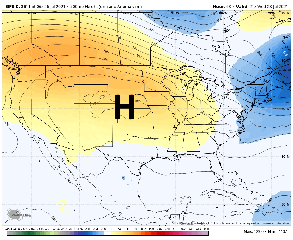
The overall pattern this week is fairly straight forward. The high pressure ridge that made for a hot and sunny weekend will shift slightly north this week, allowing for some scattered afternoon showers, before shifting southward again in time for next weekend.
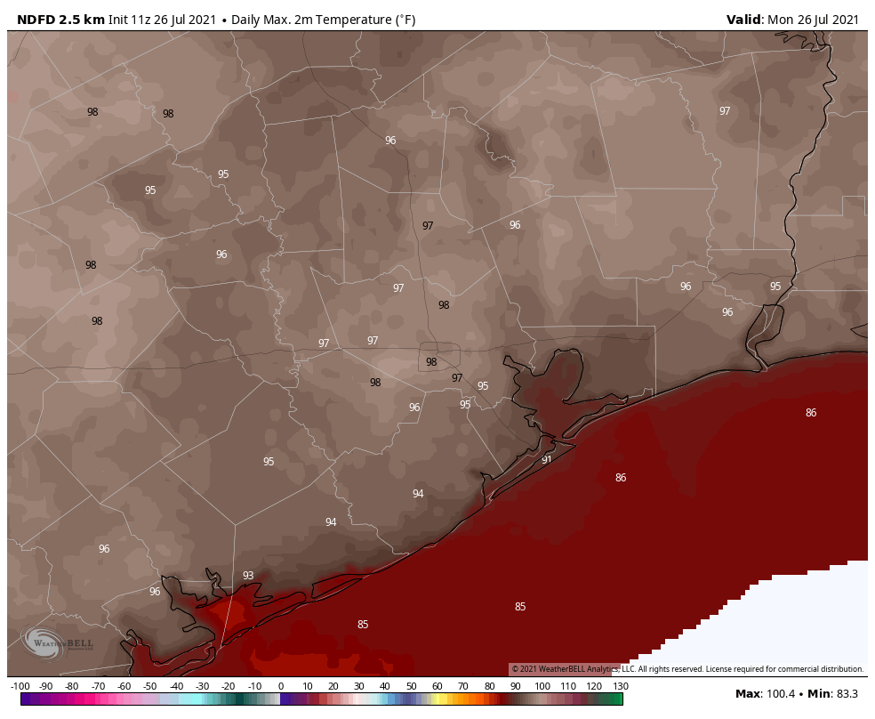
Monday will be a hot one, y’all. (Weather Bell)
Monday
Before the high pressure eases northward, Houston will see a hot and sunny day today a lot like this past weekend. We can expect highs in the upper 90s with only very light west or southwesterly winds. Lows tonight will only fall into the upper 70s.
Tuesday, Wednesday, Thursday, and Friday
Here’s what we know about the mid-week weather for the upper Texas coast. The atmosphere will be a little bit more amenable to rain showers, but rains should still be more “miss” than “hit,” and shower activity will be virtually nil during the overnight and morning hours. So basically these will be mostly sunny days except when they’re not, your daily chance of rain is probably about one-in-three, and highs will likely reach into the mid-90s. Nights should be mostly clear and sultry.
High pressure shifts to the north this week. (Weather Bell)
Saturday and Sunday
For now we expect high pressure to build more directly over the region this weekend, which should reduce rain chances. For now, therefore, our expectation is highs in the upper 90s with mostly sunny skies. Since Sunday is the first day of August, that seems appropriate.
Tropics
Overall, the Atlantic tropics remain quiet. A system near the coast of Georgia is increasingly less likely to develop, and across the rest of the Atlantic basin the chance of something else forming this week is low. Matt will have more in a tropics overview tomorrow, but the news for now is favorable. We have about two more months in which we need to watch things closely.