Although the tropics pose no specific threats to Texas, in the interests of readers of this site all along the Gulf Coast Matt and I will provide updates today and Sunday on the threat posed by Tropical Depression 19.
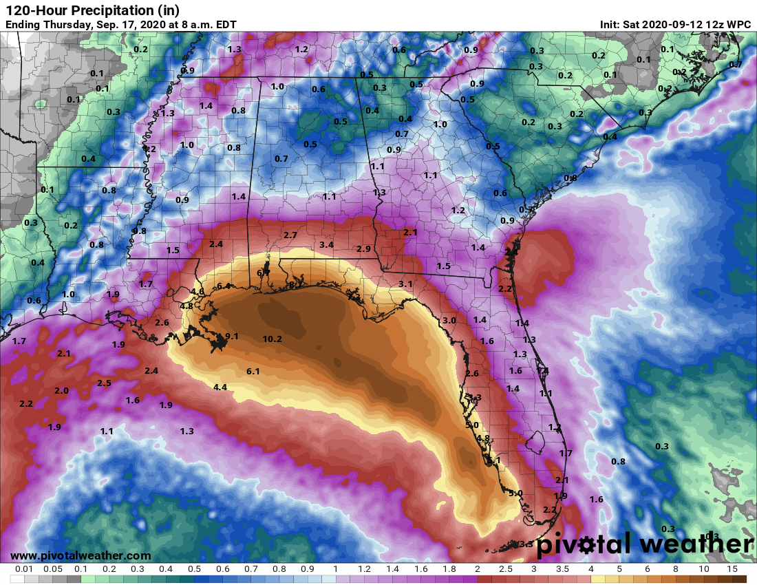
The system is passing near the southern tip of the Florida peninsula this morning, and will move into the eastern Gulf of Mexico later today. Some time today it probably will become Tropical Storm Sally. One big question is how much wind shear the storm will have to grapple with over the coming days. If shear remains low, the storm will find ideal conditions to strengthen into a Category 1 or Category 2 hurricane over the warm Gulf. Otherwise, it will remain a tropical storm. Regardless, the primary threat is probably heavy rainfall, extending from Southeastern Louisiana along much of the western coast of Florida. For the northern Gulf Coast these heavy rains would likely come some time between Monday night and Wednesday morning.
NOAA rainfall accumulation forecast for now through Wednesday. (Pivotal Weather)
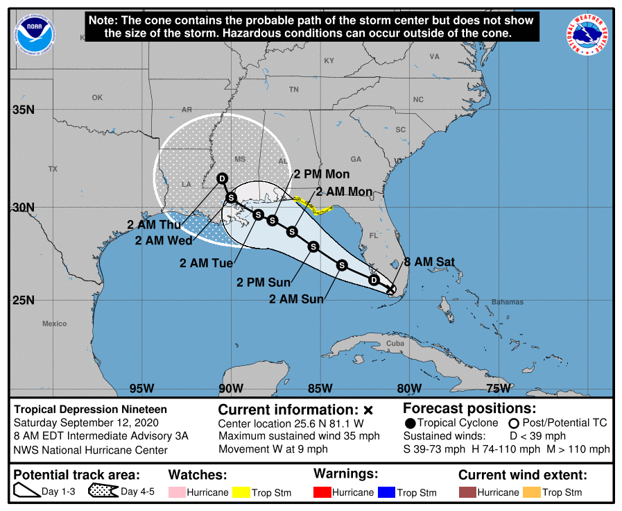
In terms of track, confidence is fairly high that the storm will make landfall somewhere between southeastern Louisiana and the Florida Panhandle—probably on Tuesday. The storm will move mostly westward or northwest until falling under the influence of a trough of low pressure over the continental United States that pulls it northward. Where precisely this happens will determine what part of the northern Gulf coast the storm strikes.
Forecast track map for TD 19 at 4am CT Saturday. (National Hurricane Center)
After this storm, over the open Atlantic Ocean, there are several other tropical waves that are candidates to develop into tropical storms or hurricanes. “Teddy” may therefore soon follow Sally. But at this time we see no specific threats to the Gulf of Mexico. In terms of the tropics, Texas seems to be in a pretty good place at this point.
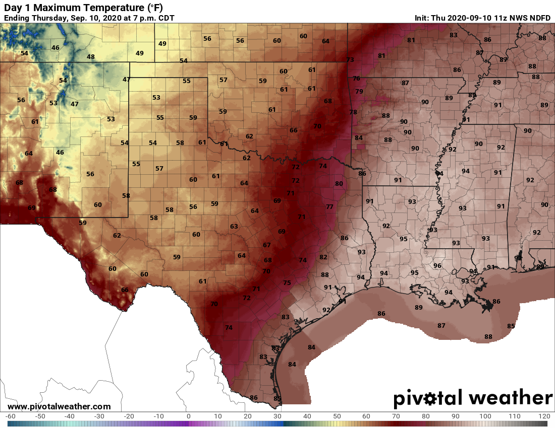
Yesterday was a really interesting day across the broader version of southeast Texas. College Station maxed out at 73° on Thursday, which breaks the record of 77° from 1948 as the coolest maximum temperature recorded there on September 10th. Much of the western half of the Houston metro area saw dewpoints drop into the 60s with cooler temps much of Thursday morning. Hobby Airport never dropped below 79° until late Thursday evening. Galveston saw heat index values approach 110°. Many of us saw some rain, with a narrow strip from about the Texas Medical Center north and east past Mount Houston into Atascocita seeing multiple rounds of storms and anywhere from 1 to 4 inches of rain.
So overall, yesterday was a glorious day for some, a frustrating day for others, and something in between that for others still. We all kind of get back on the same page today and tomorrow.
Today
The cold front is essentially dead at this point. But! The air mass over us is notably drier, yes, and you will probably notice that the humidity today isn’t as oppressive as, say, Wednesday (or even yesterday for folks south and east of Houston that largely missed any tangible impact of the front on Thursday). But it will still feel like late summer in many spots. Those of you that experienced an autumn preview yesterday will probably see upper-80s to around 90° today. Most of the rest of the Houston area will see lower-90s. But again, with humidity down it may not feel super terrible.
In terms of rain chances, look for a few showers or storms this afternoon, especially south and due east of Houston with slowly diminishing chances as you go north and west.
Tropics & weekend
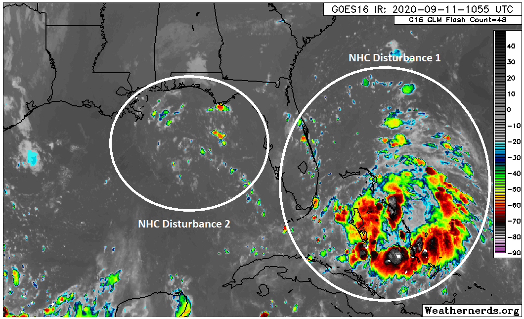
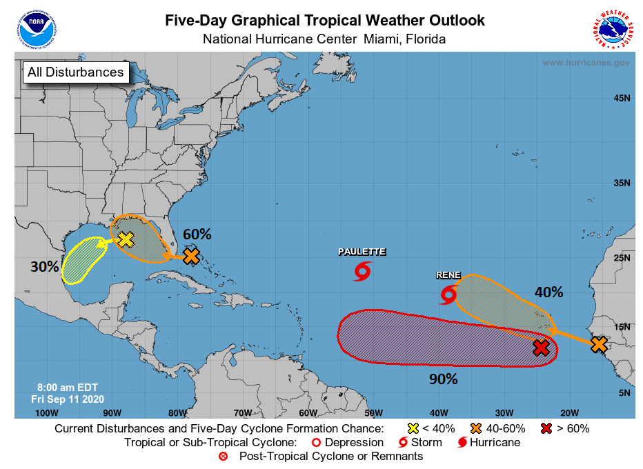
I wasn’t quite sure how to go about breaking up sections today, but given the complexity, I feel just hitting it all at once would be best. We’re watching two disturbances today, one in the Gulf and one over the Bahamas.
There are two tropical disturbances to watch, a weaker one in the eastern Gulf and a more robust one in the Bahamas (Weathernerds.org)
Clearly, one looks healthier than the other. The Bahamas one is now dubbed Invest 96L, and the National Hurricane Center is giving it a 60 percent chance of development over the next five days (40% over the next two days).
The NHC is giving the first Gulf disturbance a 30% chance of organizing over the next 5 days and the second disturbance a 60% chance over the next 5 days. (NOAA)
But we have to get through the lead disturbance first. This one has odds of 30 percent to develop over the next five days, but it seems that if it were to form, it likely wouldn’t happen until it gets south of our area toward Mexico. So why are we watching that lead disturbance? Well, it’s close enough to the coast that it will likely send a surge of moisture this way beginning tomorrow. This should be enough to generate numerous showers and storms offshore, along the coast and/or just inland on both Saturday and especially Sunday. If storms do blow up offshore significantly, it is possible that coastal areas may only see a little rain. Areas north and west of Houston may not see much rain at all this weekend.
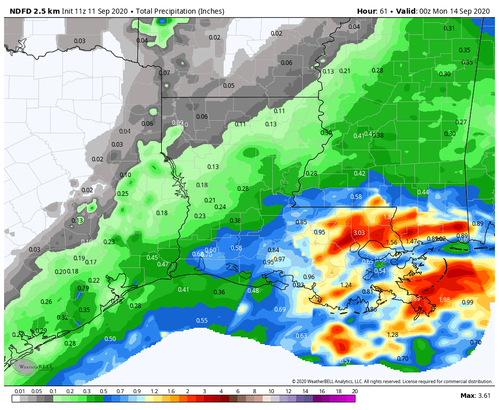
Averaging together rain chances through Sunday gives the highest totals along the coast, with lesser amounts inland. (Weather Bell)
Total rainfall from Friday into this weekend will probably average under a quarter inch north and west of Houston and closer to a half-inch near the coast. Some areas will likely see higher amounts up over an inch, and others may see no rain at all. Flooding, other than the typical ponding or minor street flooding we see in heavy downpours is not expected this weekend.
After a morning low in the 70s Saturday, we’ll see humidity inch up all day, and with highs in the 90s, expect heat index values to surpass 100° once more. Back to late summer we go. On Sunday we’ll see similar temperatures or a little cooler weather due to more cloud cover. Humidity will remain high. Watch for some choppy conditions over the bays and in the Gulf with slightly increased winds (~15 mph) with onshore flow.
Tropics & next week
The second system will not impact us, if it does at all, until at least Wednesday or Thursday. So to start the week on Monday, look for scattered to numerous showers and storms, perhaps chances push a bit farther inland than the weekend. This pattern may continue Tuesday. By Wednesday, we could see a brief break before that second system gets involved Thursday.
Simple discussion: The next tropical wave is going to slowly work west across Florida and through the Gulf the next few days, possibly developing as it does so but likely coming ashore to our east. Regardless of any of that, it will increase our rain chances by Thursday or Friday.
More technical stuff: There’s a really high degree of uncertainty at the moment with respect to that Bahamas system. One the one hand, I looked at a bunch of weather models, even the speculative ones we constantly tell people not to bother looking at for tropical systems (I need a shower now), and I don’t see a single one developing it much past where it is now; maybe one or two get to depression level. But when you look at satellite above, it looks a lot better than I would have expected today. Additionally, it’s going to be over the Gulf for a time, and it will be in a low shear environment. Realistically, this has a better shot at development than any model gives it credit for right now. The only thing I can come up with to explain why the models don’t particularly care for it, is that a good chunk of its low-level vorticity or the most “spin” associated with the system ends up along the immediate Gulf Coast or, as the European model suggests, just inland. So the models likely sense this is too close to the coast to develop. Given how far south it appears to be right now, I think the Euro may be a bit off-kilter here, and although we’d still expect a general track toward southeast Louisiana, it’s worth continuing to watch.
What does it mean for us? Right now, we’ll just call for an increase in rain chances later next week and perhaps some choppy conditions offshore with some slightly gustier winds. At this time, we do not expect significant impacts to our area (or to Hurricane Laura damaged areas) beyond increasing rain chances and slightly higher tides. But again, given the disturbance’s location and the time of year, it would be foolish to write it off completely, so we’ll keep watching.
We will also watch for maybe, possibly a new chance to see cold front by next weekend. That’s literally all I’m going to say about that for now, and if it’s still there Monday, we’ll tell you about it.
Good morning, Houston. As we watch the region’s first front approach our area, peter out, and die, I wanted to remind you one final time of Reliant’s sweepstakes to win a free AC System. We’ve already had one winner, but there’s still a second chance to win if you enter by next Tuesday. You can find an entry form, and details of the giveaway right here. It’s an entire, brand-new system—quite a deal.
Thursday
The aforementioned front has made it through College Station, and is pushing into areas such as Katy. It may make it all the way to northern parts of the I-45 corridor this morning, but it is quickly weakening. As the front stalls we should see showers develop over central and eastern parts of the area later this morning and during the afternoon. It will be the same drill as recent days, with hit-or-miss thunderstorms. High temperatures will vary widely today, from upper 70s far west of Houston to low 90s along the coast. As drier air filters in to the region, lows on Friday morning may be a few degrees cooler than normal for most of the metro region.
There will be a tremendous gradient in high temperatures on Thursday. (Pivotal Weather)
Friday and Saturday
Any semblance of the front will be gone by Friday, as summer returns in full force. Both of these days should see partly to mostly sunny skies with highs in the mid- to upper 90s. Rain chances will be lower, likely with only a few isolated to scattered showers developing during the afternoon.
Sunday through Wednesday
An upper level low pressure system will combine with a surge of tropical moisture during the first half of next week to bring better rain chances across the entire region, probably beginning later on Sunday. Right now we’re not looking at anything extreme, but I think most of Houston can probably expect to see 0.5 to 2 inches of rain between Sunday and Wednesday or so. Increased cloud cover should also help to keep highs by Sunday or Monday in the low 90s. Overall, warm, humid, summer-like weather will continue at least into next weekend.
National Hurricane Center 5-day outlook for Thursday morning.
Tropics
There are a couple of yellow blobs on the National Hurricane Center’s outlook for the next five days near the Gulf of Mexico, with 20 and 30 percent chances to develop into tropical depressions or storms over the next five days. Right now we don’t anticipate either developing into strong tropical systems, but these will be helping to drive the rain chances we mentioned earlier, beginning perhaps on Sunday.
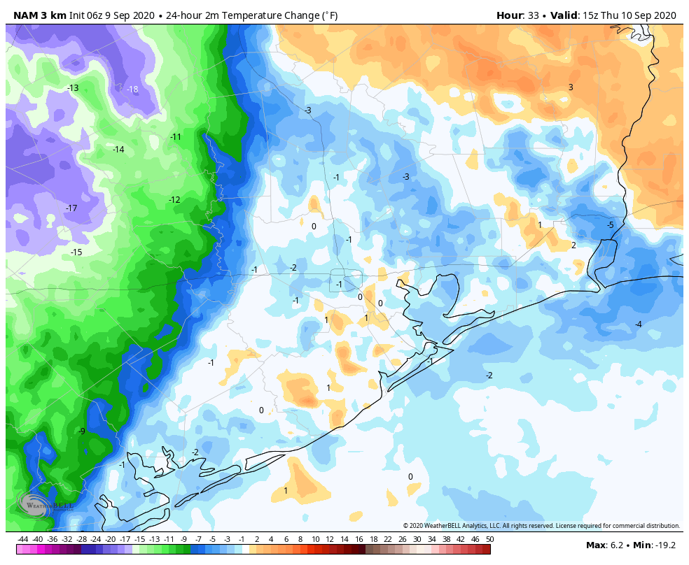
Today is such a disappointing day, my friends. As we look off to the west, we’re going to see an approaching front that, by all appearances, is going to die on our doorstep. The map below shows the likely extent of the front’s cooling by Thursday morning at 10 am CT. If the front makes it any further eastward—which is possible, although not particularly likely, we’ll consider ourselves lucky. The crushing part of all this is that our next chance for a real front probably will not come for another 10 to 12 days.
24-hour apparent change in temperatures shows the front’s extent by Thursday morning. (Weather Bell)
Wednesday
Today will be a day much like Tuesday, which is to say partly sunny skies with a decent chance of rain showers. However the heaviest rains will remain west of our region, over Central Texas, along the approaching front. The additional clouds should help to moderate temperatures a bit locally, with highs perhaps only reaching the low 90s. The front itself will likely bring a wind shift overnight, as winds blow from the northeast. But alas, this is likely to bring little sensible change in the weather in Houston.
Thursday
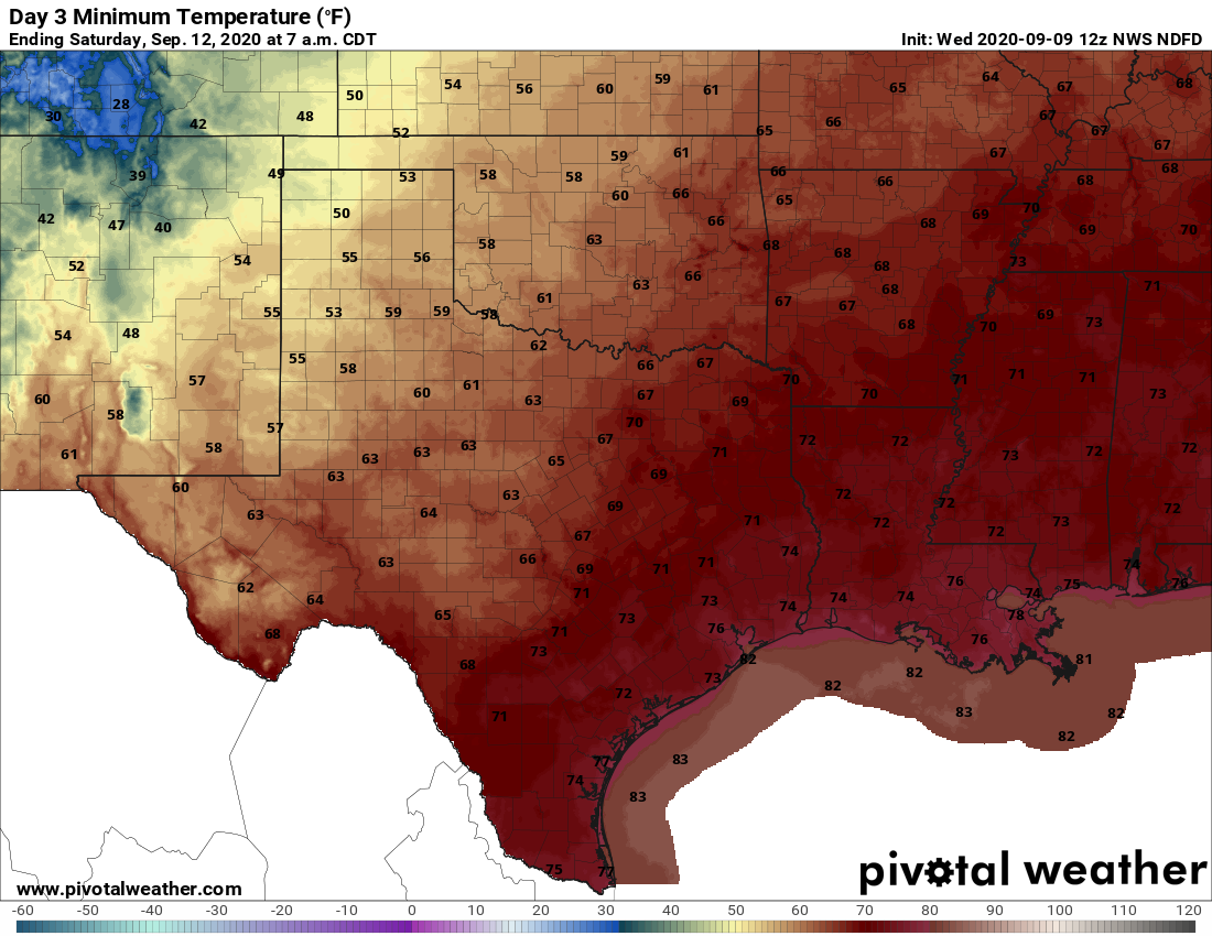
If you live north or west of Houston you may have some slight hope of a drier and cooler day, but for the rest of us Thursday will likely be a hot and sunny day with highs in the mid-90s. Rain chances will be in the 40 percent range. Thursday night may see some moderate regional cooling overnight, which is to say low- to mid-70s rather than upper 70s. And that will be the probable extent of the front’s influence on our weather—enjoy!
Friday morning’s low temperatures across the region. (Pivotal Weather)
Friday and Saturday
Summer continues, with a pair of sunny days, highs in the mid-90s, and relatively low rain chances.
Sunday and beyond
An upper-level low pressure system may combine with increased moisture at the surface to drive more widespread showers from the Sunday through Tuesday period next week, although our overall confidence in the details is low. My yard could use a few inches of rain so I’m hoping this particular forecast verifies.
Tropics
There has been no real change since Matt’s excellent overview posted on Tuesday. We still see no immediate threats to the Gulf but we’re remaining watchful as we reach the peak of the 2020 season.