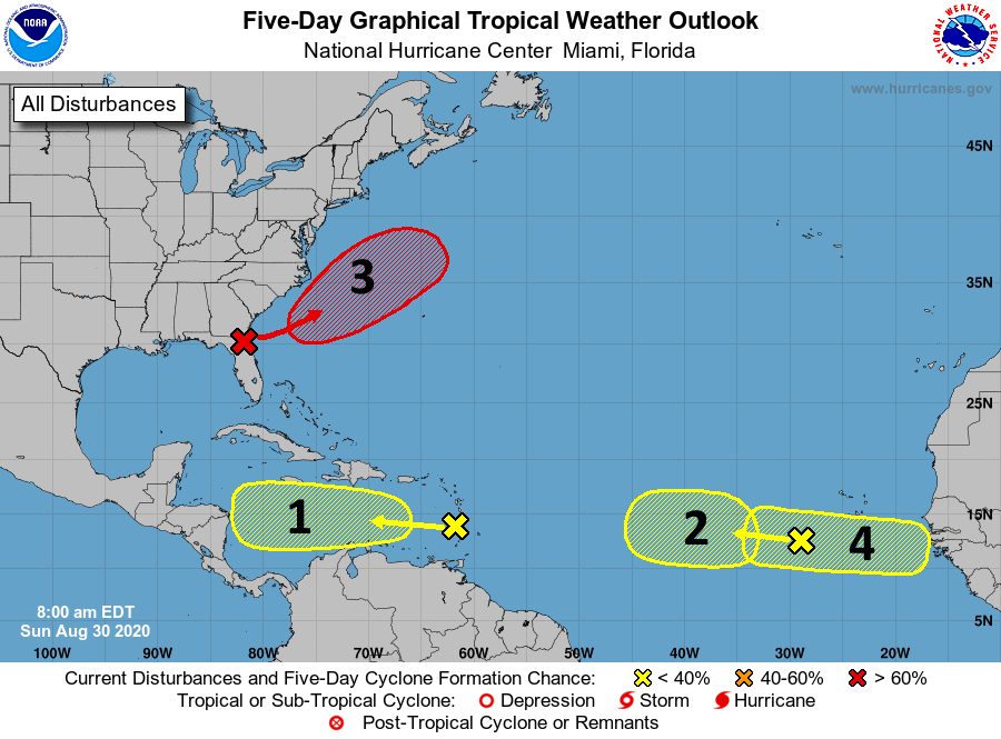
Just a quick update on Sunday morning to note the Christmas-tree like appearance of the National Hurricane Center’s Five-day tropical outlook. In the wake of Hurricane Laura this map may cause some anxiety, but the message we want to leave with you is that none of these systems—for the time being at least—really appear to be a big threat to the Texas coast.
The National Hurricane Center tropical outlook for Sunday, 7am CT.
Let’s quickly run through them.
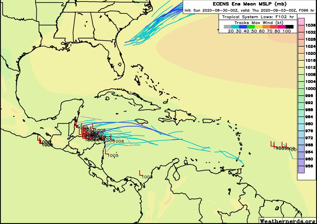
System One: On the face of it, this tropical wave moving through the Caribbean Sea would appear to be the biggest threat as it is closest, and we often see these systems turn pole-ward as they approach Central America. However for this tropical system we’re not convinced it will develop at all, and even if it does it most likely will continue plowing westward into Belize or Honduras. Here is the European ensemble forecast for the track of this system:
European model ensemble forecast for now through Wednesday night. (Weathernerds.org)
System Two: It is difficult to say whether this wave will develop, although its certainly possible. None of the forecast models are overly excited about this one, however.
System Three: This low-pressure system originated in the northwest Gulf of Mexico late last week, and is now crossing Florida. It probably will become a named storm (Nana is the next name) in the Atlantic, moving away from the United States. It will not threaten any major landmasses.
System Four: The forecast models are more bullish on this becoming a pretty well defined tropical system in about a week or so over the open Atlantic. It’s difficult to say where it would go after that, but most of the available evidence suggests it probably will not move toward the Gulf of Mexico. But as always, confidence in forecasts drops off after about 7 days.
Other threats: The peak of the Atlantic hurricane season comes in about 10 days from now, and we are seeing indications that several more potent tropical waves will move off of Africa into the Atlantic Ocean over the next couple of weeks. All of these will have to be watched. There is also the potential for something to develop in the Bay of Campeche (southern Gulf of Mexico) around 8 to 10 days from now that is worth watching. However any mischief there moving north is far from guaranteed—in fact a greater likelihood at this time is that our first fall front may be moving toward the region at that time. Cross your fingers!
So please: Be watchful of the tropics, and be wary. But at this time you should not be overly worried.
Howdy, folks—my name is Lee, and I’m the SCW server admin. I don’t post often (or really ever!), but with Eric and Matt off for the day to recover from their marathon forecasting job, I wanted to take the opportunity to talk to y’all a bit about how Space City Weather works, and how the site deals with the deluge of traffic that we get during significant weather events. This isn’t a forecasting type of post—I’m just an old angry IT guy, and I leave weather to the experts!—but a ton of folks have asked about the topic in feedback and in comments, so if you’re curious about what makes SCW tick, this post is for you.
On the other hand, if the idea of reading a post on servers sounds boring, then fear not—SCW will be back to regular forecasts on Monday!
(I’m going to keep this high-level and accessible, so if there are any hard-core geeks reading here who are jonesing for a deep-dive on how SCW is hosted, please see my Ars Technica article on the subject from a couple of years ago. The SCW hosting setup is still more or less identical to what it was when I wrote that piece just after Hurricane Harvey.)
Good afternoon. Hurricane Laura has rolled on into Arkansas this afternoon and weakened to a tropical storm. However it has left a trail of destruction in its wake. This post will be very image heavy, with a number of pictures of damage that caught my eye through the day in Louisiana that I’d like to share. A quick forecast update will follow.
Let’s start with the Doppler Radar. The Lake Charles Doppler, sited at the airport south of the city (which reported over a 130 mph wind gust) saw its radome blown to pieces.
The scenes in Lake Charles really do look like a giant tornado just ripped through the city. The one large skyscraper in downtown Lake Charles, Capital One Tower sustained severe damage. This building also took a severe hit during Hurricane Rita in 2005.
First light allows us to see the scope of the damage in Lake Charles this morning. Needless to say, its not good. pic.twitter.com/cJVI3y9Y3n
The KPLC-TV tower crumpled and fell onto or adjacent to parts of the TV station building. This one had apparently survived Audrey, Rita, and Ike, but finally succumbed to Laura.
There had been some speculation that the I-10 bridge in Lake Charles (which, if you’ve ever driven, you just know, trust me) might sustain difficulties under a record storm surge. Well, it’s still standing, although it has a casino boat stuck underneath today.
Lake Charles did not receive the expected record surge thanks to a landfall basically right at Calcasieu Pass (had it hit land even just five miles west, the story today would be much different), but they did receive a pretty serious surge in that area.
That surge was notable, however, it can be seen from space.
The effects of #Laura’s storm surge in SW Louisiana is visible on satellite. The top image is Tuesday and the bottom image is now. Note the temporary regression of the coastline. This water will gradually retreat into the Gulf, but this shows how big of an impact surge can have. pic.twitter.com/OVShOy2KcD
You can see especially east of Calcasieu Lake (the 2nd larger inland lake from the left) how much land mass ended up underwater. There is a reason that part of coastal Louisiana is not heavily populated.
Back in the Lake Charles area, in addition to everything, a large fire broke out (not at oil refineries as the tweet says) at the KIK Custom Products Biolab in Westlake, just off to the west of the city. The fire prompted a shelter in place order for the area.
Moving even farther south to the coast, Holly Beach is a mess, though it does not look as bad as feared. They came in just west of the eye and avoided the absolute worst of Laura.
However, for a sobering view, here’s helicopter footage from Cameron, where Laura came ashore. Note the occasional slabs where structures used to stand.
Anyway, the purpose of showing you these photos and videos, aside from informational value is to understand that Lake Charles is about 30 miles from the coastline. If a northwest moving storm of Laura’s size and intensity came ashore at, say, San Luis Pass (an Alicia track but with a larger & stronger storm), the result would be a very large chunk of the Houston area resembling what we see in Lake Charles. It would be devastating. And if you think it couldn’t happen here, think again. It could easily happen, and I’m fairly confident we are not even remotely prepared for what that would look like. Instead of viewing Laura as another Houston near-miss, it would be wise for all of us to view this as an informational session on what could happen here and think about what we will do in the days before it does.
Houston weather
I just want to make a quick note about the weather here in Houston tomorrow. We’ve seen signs on the models that sort of a trailing band of moisture feeding Laura’s remnants will set up over southeast Texas and Louisiana. At this point, we’d just expect scattered thunderstorms across the area on Friday. However, it’s feasible that a slower moving band of heavier rain sets up somewhere near or east of Houston tomorrow and dumps some heavy rainfall.
The Weather Prediction Center has the eastern part of the Houston metro area in a borderline marginal/slight risk of excessive rainfall tomorrow, meaning heavy rain is possible. (NOAA)
The Weather Prediction Center of NOAA has the eastern fringe of the metro area not far from a “slight” risk (Level 2/4) of excessive rainfall Friday. While this is more likely to be directed into Louisiana, it’s entirely possible this sets up closer to Houston. So, we just want you to be aware of the risk of some locally heavy rainfall tomorrow. Thankfully, we didn’t see much of anything during Laura’s passage, so we have a good amount of room to absorb any rains.
As of right now, Eric and I are intending to take tomorrow off as a necessary recovery day. However, if it appears the rain risk will become more significant, we’ll chime in with an update. In the meantime, have yourselves a good evening.
Well, it’s over for the coast. After making landfall early Thursday morning at Cameron, Louisiana, Hurricane Laura has continued to move northward at a fast clip, about 15 mph. At 7 am CT the center was located near Fort Polk, Louisiana, with maximum sustained winds of 100 mph. Sometime later today or this evening Matt will be along to provide a roundup of its many, many damages. Some of the first-light images this morning show about what you would expect.
Now, for a change, we’ll actually do a forecast for Houston rather than focusing exclusively on the tropics. If you’re new to the site, most of the time, we provide a once-a-day forecast on weekday mornings. (Because, hey, sometimes there’s only so much you can write about Houston’s weather when it’s hot, sunny, and humid). As ever, if inclement weather threatens, we’re here 24/7. Since that is no longer the case, we’ll return to our regular programming.
Thursday
As Laura pulls away from the Gulf coast Houston is seeing a dry, northwesterly flow. This has made dewpoints a few degrees lower this morning across the region, at the surface. We’re going to see some clouds today, but despite this, thanks to the drier flow, it’s still going to get plenty hot. Look for low to mid-90s near the coast, and upper 90s inland. For coastal areas, after astronomical high tides occur this morning, we expect any residual high water to recede. Rain chances will remain near zero until late this afternoon or the overnight hours, but even then will remain quite low.
Friday
This day offers the best chance of rain, as Laura pulls away and the onshore flow resumes. The following map of precipitable water shows the center of Laura on Friday shortly afternoon, and the trailing remnants of moisture that may produce some showers and thunderstorms over Houston. I’d rate rain chances at 40 to 50 percent, better to the east than west, and accumulations don’t look overly impressive.
Precipitable water forecast for 1pm CT Friday. (Weather Bell)
Skies will be partly to mostly sunny, on Friday but the increased moisture should help limit temperatures into the mid-90s.
Saturday and Sunday
Our weekend forecast calls for mostly sunny skies, with highs in the mid-90s. We think there will be enough residual moisture along the coast to generate at least some scattered showers. But I don’t think we’re going to get the kinds of widespread showers the region sort of needs after a mostly quite dry August. (In this sense, while Laura’s more eastward track saved Houston from any significant winds, it also kept a decent shot of rainfall away). In any case, most outdoor activities should be fine, just have a plan to deal with a passing shower.
Next week and beyond
The first week of September looks fairly hot and sunny—standard fare for this part of the year. As for rain, there will be some, but probably not much. Some of the models are starting to flirt with a cool front reaching Houston by around September 10, but there are so many “mirage” fronts at this time of year I’m not buying it for now.
Tropics
Beyond Laura we’re seeing the potential for more activity, but there are no imminent threats to the Gulf or Caribbean so let’s just all breathe a sigh of relief. We’ve got another four or five weeks to get through and then we’re really into fall.