Welcome to Eye on the Tropics, Powered by Reliant.
With the formation of Fay last week, we’re off to the fastest start on record in the Atlantic basin if you used named storms as your benchmark. Thankfully, we are setup right now for a bit of a quiet period, possibly through the end of July.
Tropical outlook in a sentence
We do not expect any tropical activity of note for the 7 days and probably longer.
Fast start should slow again
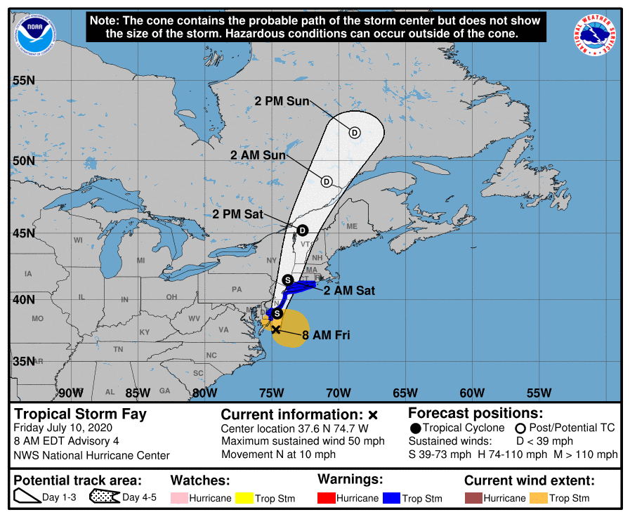
Two weeks ago, we had Edouard to discuss. Last week, we hinted at the risk that Fay could form. That happened, and now things are once again quiet in the tropics. We don’t see any sneaky system risk for the next 5 to 7 days, and nothing of note seems to be showing up beyond that. So we can exhale for the time being, and let us revisit 2020’s frenetic pace.
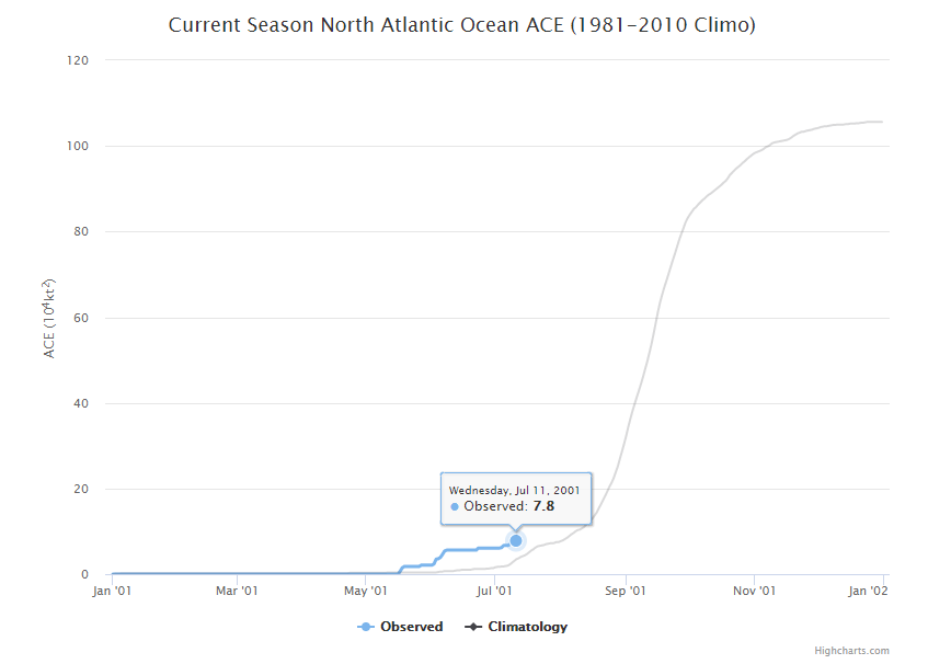
Fay was the fastest we’ve gotten to the “F” storm, or 6th named storm on record in the tropics, with the usual caveat that we easily could have missed a storm or two in previous years before weather satellites. Still, that is what the record books will say. Typically, we don’t get to the letter F until about September 8th. Of course, as we know, all of this year’s tropical storms have been fairly pedestrian in nature. The accumulated cyclone energy (or the sum of wind speed every 6 hours for every storm) is a mere 7.8, or what is typical for August 2nd.
The earliest “G” storm is 2005’s Gert on July 24th. It seems unlikely that this domino will fall right now. So far at least, this year is about quantity, not quality. That isn’t a bad thing.
What is next?
The obvious question everyone will have is: If things are going to quiet down, when will we see the next wave of activity? The answer is that we don’t know. Now, I will say that the risk of activity over the next 5 to 7 days seems close to zero. However, once we go beyond that period, there is always a chance something rogue could develop local to the Gulf that is absent from all models at present. We don’t see any evidence of that being a risk right now, but folks should understand the time horizon we can reasonably forecast for is limited when it comes to these things. But at a large scale, things look to remain quiet for probably the next two weeks.
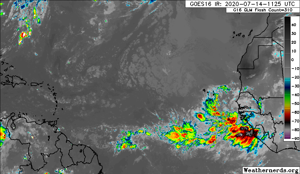
Dust is still pretty widespread, and even though we should begin to see beefier waves emerge off Africa, the odds of any one developing is fairly low. Looking at some meteorological data, it would seem to me that early to mid-August may provide our next chance to begin to get some development going on any meaningful scale. By then, dust and dry air should begin to become a little less dense, and we may see some background level support for more activity. One issue plaguing the Atlantic right now, despite a lot of other background signals being supportive of a very busy season is that vertical instability is rather low.
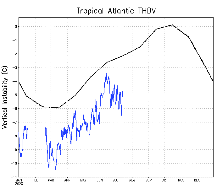
We can use this as sort of a rough gauge as to what kind of state the Atlantic is in, and right now it happens to be in a pretty suppressed one, which does not support storm formation. Instability breeds thunderstorms, which can breed tropical storms. This doesn’t need to be rocking for the season to be active, but if you were seeking development of a meaningful nature, you would want to see this change. That being said, we’ve had six storms with really depressed basin-wide instability. If this does turn a corner, it’s likely that we’re going to be off to the races.
Hurricane season is a marathon, and there are numerous signals and hints you can focus in on or get distracted by. While this is a rather significant signal right now, and it’s likely helping us to keep quiet for the time being, it does not mean it will last forever. We will maintain vigilance. More for you next week!