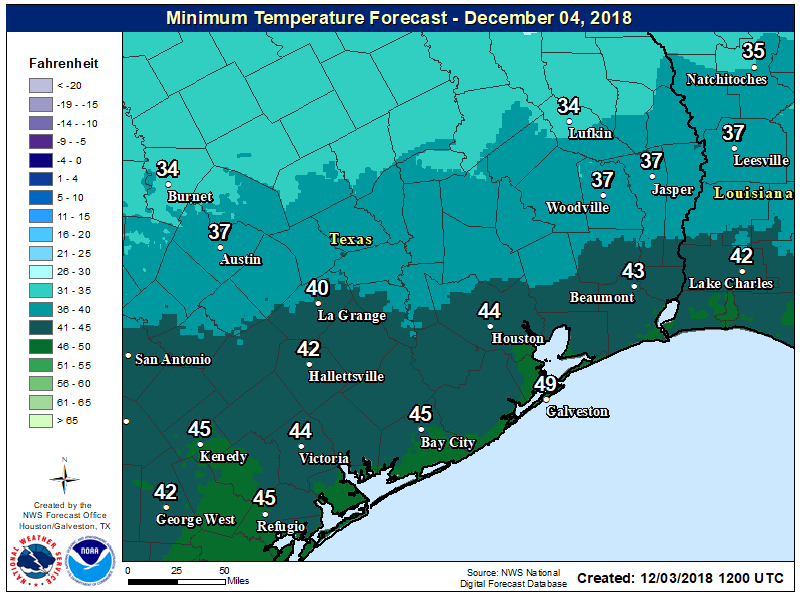
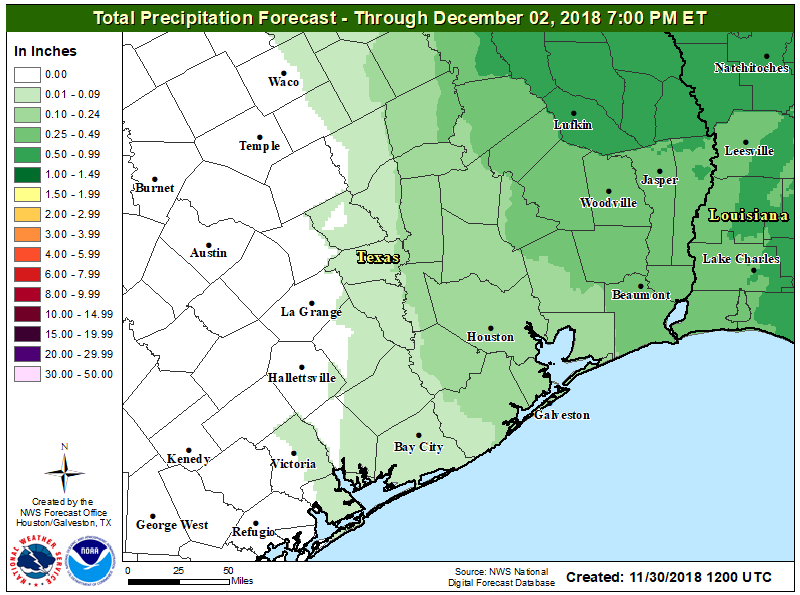
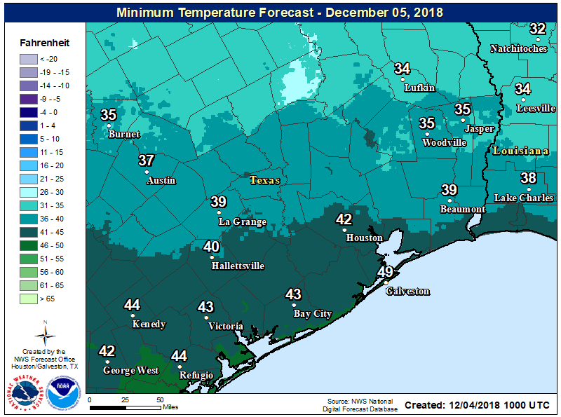
Summer lite returns to Houston, and it will remain awhile

Nine years ago today, Hurricane Ike made landfall along the northern end of Galveston Island. Of a hurricane’s three major threats—damaging winds, storm surge, and inland flooding—Ike’s greatest damage came from its surge along the coast. In the nearly decade since then, we’ve done nothing to mitigate the problem of surge. It would be a great shame if we make the same mistake with regard to inland flooding after Hurricane Harvey.

An aerial photo of damage in Gilchrist, Texas, after Ike. (FEMA)

Now, onto the forecast.

Wednesday through Friday

Southerly winds are back, and with it comes increased humidity and warmer nights. Overnight lows this morning are nearly 10 degrees warmer than just 24 hours ago. We won’t see too much of a difference in high temperatures over the next several days, with the mercury climbing to about 90 degrees or so. But it will feel warmer, given the increased moisture and humidity. This is more typical weather for September.

See full post

End of Texas tropics season may be near as Houston warms back up

Well, it has been a busy few weeks in the tropics with hurricanes Harvey, Irma, Katia, and now Jose meandering around the Atlantic Ocean. (Speaking of Jose and its track forecast, while the 75-mph storm may move back toward the US East Coast this weekend or early next week, as of right now it most likely will stay offshore). Perhaps not surprisingly, the Atlantic season reached its “peak” of activity on Sunday. As you can see, however, a good bit of activity historically continues into early November.

Graphic showing frequency of hurricane activity in the Atlantic Ocean. (National Hurricane Center)

But for Texas it’s a different story. I am not ready to declare an end to the Texas hurricane season, but long-time readers will recall that after Sept. 24th the chance of a hurricane hitting the state are historically quite low. Moreover, forecast models show little to no tropical activity in the Gulf of Mexico for at least the next week or 10 days. So we’re getting close to that date, and after Hurricane Harvey we’ve certainly had enough of the tropics for awhile. I’ll post later this month when I think we’re all clear on the tropics front.

Now let’s take a look at our forecast for the next week.

See full post

Do you miss the rain yet, Houston?

For Houston, Hurricane Harvey’s rainfall ended on Tuesday, August, 29. A few parts of the region have seen some light showers since then, but essentially it has been bone dry for the last 12 days. This has been exactly what the doctor ordered in terms of recovery from what likely will be the costliest natural disaster in US history. And the low humidity has been nice too. Yet already, our soils are starting to dry out. So when is the rain going to return? The short answer is not soon.

Houston got a lot of rainfall during Harvey, and then it has stopped. (National Weather Service)

Today

For most area school districts, this morning represents a second “back to school” day, and we will have fine weather, with lows this morning in the 60s, and highs today in the mid- to upper-80s.

Tuesday

We’re going to have one more really nice fall-like day on Tuesday, with lows generally in the low 60s across the area and some really nice, dry air blowing in from the northwest. Highs will be in the upper 80s. Savor the mornings, because change is coming.

See full post

Hurricane Irma reaches Keys, will bring disaster to Florida

When it comes to measuring the intensity of hurricanes, the most widely understood metric is sustained wind speed, and this morning Irma has regained some strength, to 130 mph. However for scientists, the more accurate determinant of intensity is central pressure—the extent to which a storm’s center is lower than the Earth’s normal sea-level pressure of 1013.25 millibars. This morning, Irma’s central pressure has been hovering just below 930 millibars. Although far from a record, only six US hurricanes have made landfall with pressures below this—The Indianola storm, the 1919 Florida Keys hurricane, the 1935 Labor Day storm, Camille, Andrew, and Katrina. All are legendary storms. This provides some sense of what is now crossing the Florida keys and moving toward the Florida peninsula.

Intensity and Track

Irma finally turned to the north-northwest on Saturday night. While the delayed turn was a surprise to some, we have been discussing the possibility of Cuba-then-southeastern Gulf of Mexico scenario since last Tuesday. The Cuba interaction weakened Irma substantially, from 160mph down to 120mph, but since moving back into the Florida Straits on Saturday afternoon, the storm has begun to regain some strength, to 130mph as of 7am CT Sunday.

Irma will now move through much higher wind shear than it has seen for days. (CIMSS/Space City Weather)

Fortunately, the window for restrengthening is short. Later today Irma’s center will begin to interact with the southwestern part of Florida, and this will disrupt the storm’s organization. Another critical factor is wind shear, the varying direction of wind speeds at different levels of the atmosphere. Irma has had a very smooth go of it for days (less than 20 knots). But it has now reached an area of higher shear (shown above), and this should help to weaken the storm considerably over the next day. Here’s the official forecast for winds over the next three days as Irma moves inland.

Forecast maximum sustained winds for Irma. (National Hurricane Center/Space City Weather)

See full post