Houston’s temperature hit 100 degrees for the first time in a year on Sunday, reaching 100 exactly at Bush Intercontinental Airport. However, of more note have been the “low” temperatures overnight, which on the last four nights have only fallen to 80 degrees. This has set or tied a “high minimum temperature” record for each of the last four days. This only adds additional stress to the region’s ecosystem—not to mention people who live without air conditioning—on top of the already high daytime temperatures. Fortunately we only have one more extremely hot day before the heat breaks slightly.
Daily temperatures in August at Bush Intercontinental Airport. (National Weather Service)
Monday
A heat advisory remains in effect for today, until 9pm, as high pressure will lead again to mostly sunny skies and high temperatures of about 100 degrees across the region. By now, you know the drill, as today will be a lot like Saturday and Sunday. Areas to the northwest of Houston, including the Bryan-College Station region, are under an “excessive heat warning” because high temperatures could reach into 105-degree range for some areas.
Thursday was the hottest day yet in this heat wave that is scorching much of Texas. It was also Houston’s hottest day since June 5th. We hit 98° officially at Bush Airport (96° at Hobby).
Across Texas, it was quite a day. Here’s a rundown of the noteworthy temperatures and records set:
Energy demand across Texas was the strongest it has ever been, with the Electric Reliability Council of Texas, or ERCOTestablishing another record, breaking the previous one just set on Wednesday.
Houston‘s low of 80° tied a record warm minimum temperature for July 19th.
College Station hit 100° yesterday for the first time in 2018.
Dallas, Waco, and San Angelo set record high temperatures for July 19th of 108° on Thursday, breaking records from 1925, 1951, and 2011 respectively.
Incredibly, Lubbock, TX didn’t drop below 81° yesterday for the first time on record, their warmest low temperature for any date by two degrees. Records in Lubbock date to 1911.
Midland, El Paso, and Amarillo each hit 105° for a high yesterday, tying records for Midland and El Paso for the date and setting a new record for Amarillo, which had been 102° last set in 1936.
Austin hit 104° and San Antonio hit 99°, neither of which were records.
Across the border, Shreveport, LA hit 104° yesterday, tying a record for Thursday last set way back in 1875.
The heat hasn’t even peaked yet, certainly not for Houston, so expect more impressive numbers and records to come. Let’s run through the forecast.
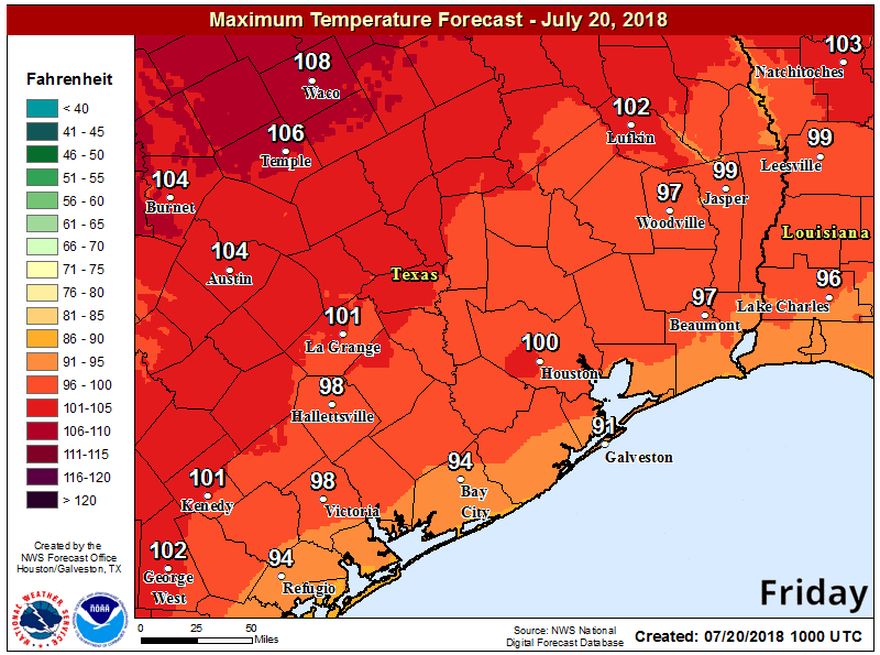
Friday & weekend
All three days look similar from a pure weather standpoint: It will be sunny and hot into Sunday. Please use caution if outdoors. Yes, we’re used to hot weather, but what’s coming this weekend is the next level of heat for our area that we see maybe once or twice per summer.
Some heat safety tips. Limit your time outdoors, don’t forget to check the backseat of your car, and please don’t forget about pets. (NWS)
In terms of just how hot, I would say we hit 98-100° officially today, followed by about 99-101° Saturday, and 101-103° Sunday. While Houston has been on the periphery of the strong upper level ridge of high pressure that has caused this heat, it will advance toward us in a big way this weekend, giving us a taste of what North Texas has been experiencing. How generous.
Official NWS forecast high temperatures over the next few days have lots of 100s showing up. (NWS)
We get very little relief at night during this kind of heat, so expect low temperatures to get just below 80° in most places and not much better than that.
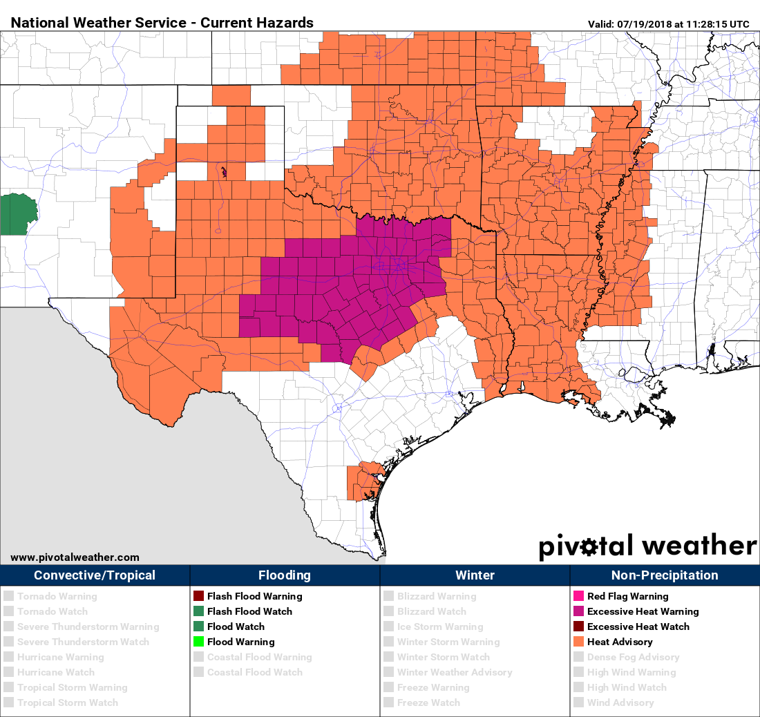
We’ve been talking about the heat this week, and upcoming weekend, for quite a while and unfortunately it will be as bad or worse than expected. The heat is especially extreme in the northern half of Texas, where high temperatures may reach 110 degrees, and areas such as Dallas and Fort Worth will see some of the worst heat since 2011. Heat advisories have been issued for the northern half of Texas, as well as some more extreme heat warnings for DFW and surrounding areas.
Heat advisory (orange) and warning (purple) map for Thursday. (Pivotal Weather)
Additionally, the Electric Reliability Council of Texas, or ERCOT, reported on Wednesday that it set a new, all-time systemwide peak demand record during the afternoon, reaching 72,192 MW between 4 and 5 p.m. Electricity usage will only get higher this weekend as it gets slightly hotter than now, and you can help by conserving electricity (see how at the end of this post).
Thursday
Houston, with its proximity to the Gulf of Mexico, won’t bake quite as much as northern Texas due to high pressures. But it will still be hot and sunny. Expect highs in the upper 90s with lows tonight near 80 degrees.
The forecast remains virtually the same, day by day, for the next week as high pressure dominates our weather. So this post will also take a look at expectations for the rest of the Atlantic hurricane season, which began about seven weeks ago.
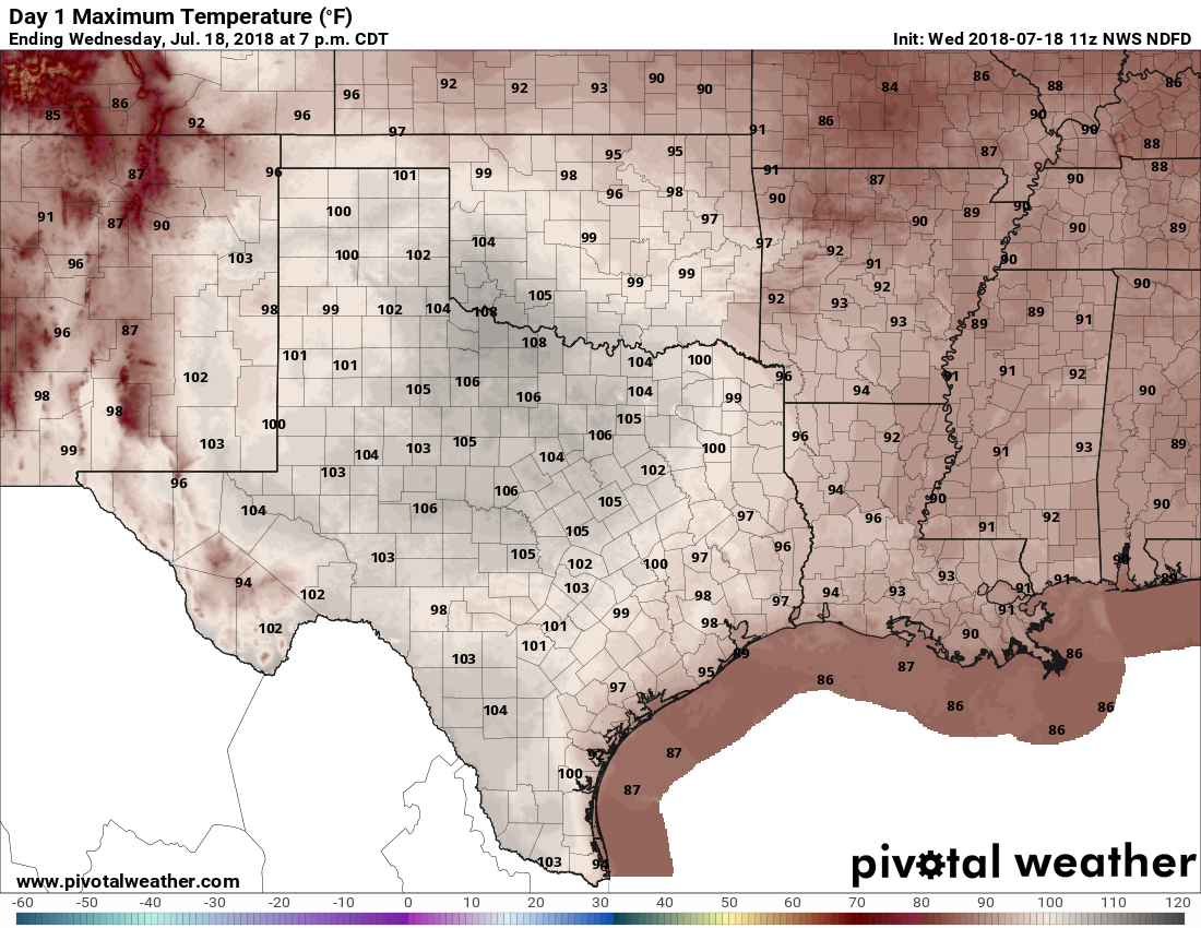
Wednesday
Hot, mostly sunny, with highs in the upper 90s. Afternoon heat index values will be 105 degrees or higher, so please take care outside.
Texas will be mighty hot today. (Pivotal Weather)
Thursday, Friday, Saturday, and Sunday
More of the same. I expect high temperatures at one point this weekend will reach 100 degrees. Forecast conditions just won’t change much day by day: Heat, sunshine, no rain, high humidity. This is the Houston we know and love. Right?
Next week
The high heat continues for the first half of next week, but there is a chance the high pressure system will break down during the Wednesday through Friday period, allowing for some decent rain chances to return, and for temperatures to fall back into a slightly more reasonable range. It’s something to hope for.